
Mori Atlas logo
Nature reserveSteinbrinker-Ströhener Masch

Discover the geographic boundaries, meadow bird habitats, and moorland buffer terrain of this Lower Saxony nature reserve.

Steinbrinker-Ströhener Masch Nature Reserve: Mapping Protected Wetland and Fen Peat Landscapes in Germany

(Naturschutzgebiet Steinbrinker-Ströhener Masch)

Steinbrinker-Ströhener Masch serves as a significant nature reserve within the Diepholzer Moorniederung complex of Lower Saxony. This protected area safeguards extensive fen peat grasslands, utilizing ditch management to sustain vital wet meadows for species such as curlew, lapwing, and snipe. Positioned at the junction of regional moorland systems and transitioning into the Naturpark Dümmer, the landscape provides essential ecological buffers across low-lying terrain.

nature reservewet grasslandfen peatlandmeadow birdsmoorland bufferlowland habitats
Vector illustration of a green meadow with tall grass in the foreground, forests on either side, and a wind turbine in the distance against a pink and blue sky with a sun.

Steinbrinker-Ströhener Masch

Nature reserve

Park overview

Structured park overview, official facts, and landscape profile for Steinbrinker-Ströhener Masch

Steinbrinker-Ströhener Masch park facts, protected area profile, and essential visitor context

Review the core facts for Steinbrinker-Ströhener Masch, including designation, size, terrain, visitor scale, habitats, and operating context in one park-focused overview.

About Steinbrinker-Ströhener Masch

Steinbrinker-Ströhener Masch is a nature reserve in the rural northwestern lowlands of Lower Saxony, focused on protecting seminatural wet grassland on low-lying peat soils. It sits in a transitional landscape between the open Diepholzer Moorniederung to the north and east and cultivated farmland further south, occupying a strategic position where drained farmland meets relict peatland systems.

The protected area's identity is shaped by its integration into the larger Diepholzer Moorniederung, an extensive wetland landscape recognized under the EU Birds Directive. This places the reserve within a framework of international conservation interest, even though it is a relatively modest local site. Its western and northern edges touch the Naturpark Dümmer, linking it to a broader mosaic of moorland, lake, and grassland protected areas in the region.

Functionally, the reserve is defined less by dramatic scenery than by careful hydrological management. Ditches are partially dammed so that parts of the grassland are periodically waterlogged, recreating conditions that benefited many of the bird species once common across the northwest German lowlands. This combination of re-wetting and extensive land use forms the core of the reserve's conservation strategy.

Because the area lies at the margins of larger raised bogs, it also serves as a buffer zone. Forest patches and shrub habitats within the reserve host woodland birds such as golden oriole, red-backed shrike, and hobby, while temporary meadow pools occasionally fill in spring, providing breeding habitat for amphibians.

Quick facts and research context for Steinbrinker-Ströhener Masch

Steinbrinker-Ströhener Masch is a state-designated nature reserve (Naturschutzgebiet) in Lower Saxony, classified as IUCN Category IV (Habitat/Species Management Area). It carries the official identifier NSG HA 153 and World Database on Protected Areas entry 165683.

The reserve lies in the Diepholz Moor lowlands and spans parts of the Diepenau municipality in Nienburg district and Wagenfeld in Diepholz district. It is wholly contained within the EU Birds Directive site "Diepholzer Moorniederung."

Established on 14 November 1991 and expanded in summer 2017, the area is administered by the NLWKN (Niedersächsischer Landesbetrieb für Wasserwirtschaft, Küsten- und Naturschutz) in cooperation with the lower nature conservation authorities of the two involved districts.

Protection and recognition

Examine terrestrial protected area parameters and documented recognition sources for Steinbrinker-Ströhener Masch.

Steinbrinker-Ströhener Masch Protection Status and Official Designation Record

Terrestrial protection metrics and administrative recognition records define the conservation framework surrounding Steinbrinker-Ströhener Masch. Official database references provide verified parameters for exploring the designated landscape geography without supplementary assumptions.

Protection details

Protection scope
Terrestrial
Transboundary protection
No
WDPA ID
165683
Park context

Deeper park guide and search-rich context for Steinbrinker-Ströhener Masch

Steinbrinker-Ströhener Masch history, landscape, wildlife, and travel context

Explore Steinbrinker-Ströhener Masch through its history, landscape character, ecosystems, wildlife, conservation priorities, cultural context, and seasonal travel timing in a structured park guide built for atlas discovery and search intent.

Why Steinbrinker-Ströhener Masch stands out

The reserve is best known for its populations of meadow-breeding waders and grassland birds associated with fen peat meadows. Snipe, lapwing, redshank, and the large Eurasian curlew are characteristic species, with quail and skylark occurring on cultivated parts of the site and meadow pipit and stonechat in the wetter fringes. It is also recognized for its buffer role between intensively used peatland edge habitats and high-moor areas of the Diepholzer Moorniederung. By maintaining damp, extensively managed grassland next to raised bog, the reserve supports both breeding meadow birds and foraging habitat for species that range across the surrounding moors.
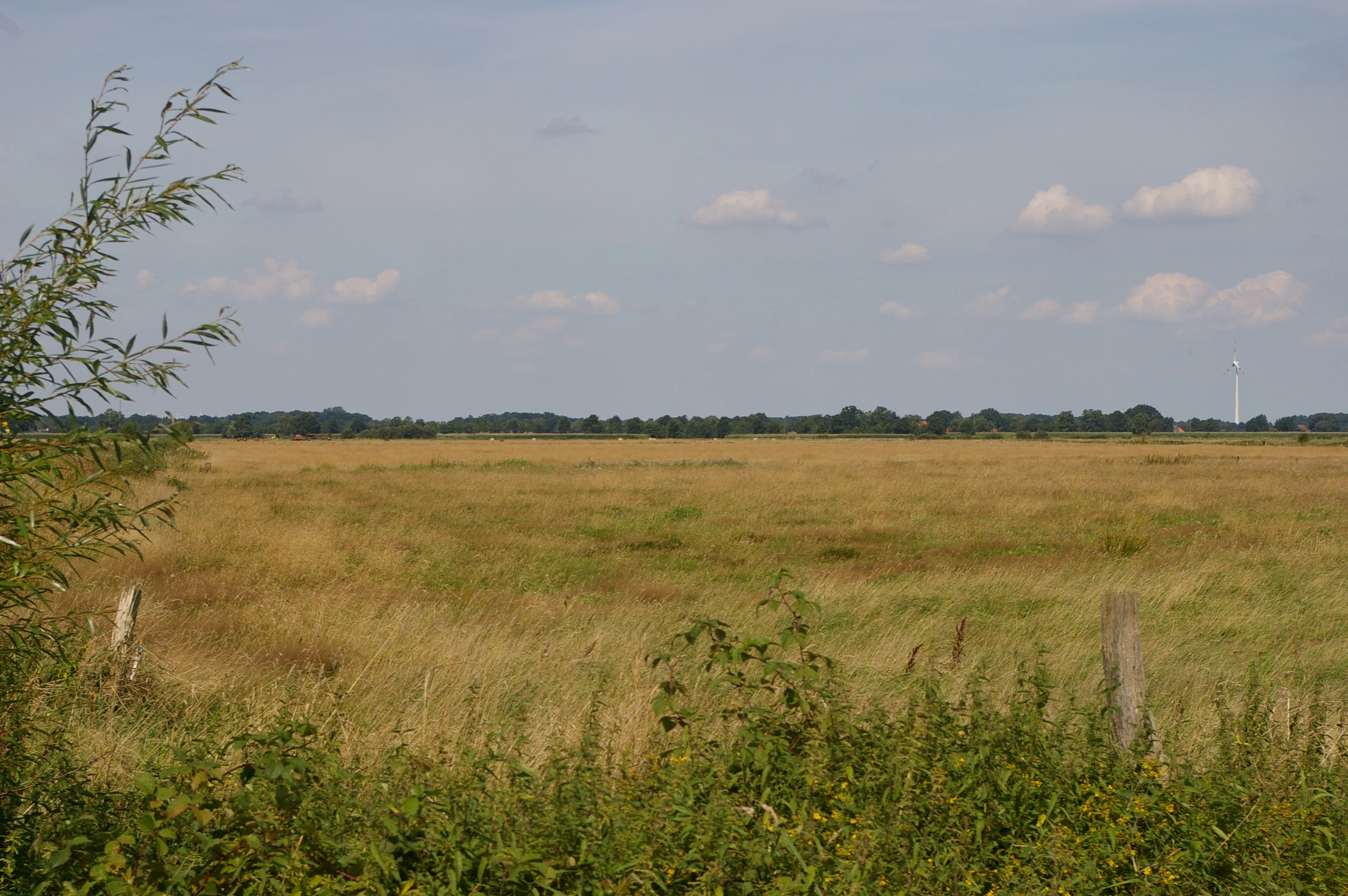
A wide, flat grassy meadow under a blue sky with scattered clouds, bordered by a line of trees in the distance and green bushes in the foreground.
Landscape view of the Steinbrinker-Ströhener Masch nature reserve.

Steinbrinker-Ströhener Masch history and protected-area timeline

The Steinbrinker-Ströhener Masch was officially designated as a nature reserve on 14 November 1991, with an initial area of around 255 hectares. The protection was established to safeguard fen peat grassland and the meadow bird populations these habitats support, within a region already recognized for its importance to wetland birds under the EU Birds Directive.

In summer 2017, the reserve was expanded to its present size of about 325 hectares. The enlargement brought additional areas into protection along the western edge of the site, incorporating land that was already part of the surrounding EU Bird Directive site and strengthening the connection between the reserve and adjacent moorland habitats.

Since its designation, the reserve has been managed under the authority of the NLWKN in coordination with the lower nature conservation authorities of the districts of Nienburg and Diepholz, which together cover the two municipalities in which the site lies.

Steinbrinker-Ströhener Masch landscape and geographic character

The landscape of Steinbrinker-Ströhener Masch is a flat, low-lying terrain typical of the northwestern German peatland region. Elevations range only from about 35 to 38 meters above sea level, and the surface mirrors the gentle topography of the surrounding Diepholz Moor lowlands. There are no dramatic landforms; instead the scene is shaped by small-scale variation between damp meadows, ditches, scattered woodland, and arable parcels.

The reserve sits between the larger peatland systems of the region, especially the Uchter Moor to the east and the Nordeler Bruch to the south. Near the moors, the reserve functions visually and ecologically as a buffer, with the wet meadows grading into more enclosed bog-edge habitats. To the west, the landscape transitions toward the broader recreational landscape of the Naturpark Dümmer.

Hydrology is a defining feature. Dams within drainage ditches periodically raise water levels across parts of the grassland, producing seasonally saturated fields. Combined with the flat terrain, this gives the area a characteristic open, marshy feel during the wetter parts of the year, while drier summer conditions can give way to more conventional meadow and arable appearances.

Steinbrinker-Ströhener Masch ecosystems, habitats, and plant life

The reserve's ecological identity centers on lowland fen grassland, a habitat now rare and heavily fragmented in northwestern Germany. The soils are low-lying peat (Niedermoor), and the grassland depends on careful water management to maintain its typical vegetation and breeding bird community.

Vast parts of the reserve are managed as extensive grassland, with light grazing or mowing regimes that preserve the structural diversity needed by meadow birds. Smaller portions are used for arable farming, and even these cultivated fields contribute to habitat diversity, hosting ground-nesting species adapted to open farmland.

Hedgerows, shrub patches, and small woodland stands break up the open ground and provide habitat for woodland and edge species, complementing the open grassland fauna. Temporarily water-filled depressions in the meadows add a further habitat layer and periodically support amphibian breeding.

Steinbrinker-Ströhener Masch wildlife and species highlights

Steinbrinker-Ströhener Masch is especially significant for breeding waders and other open-land birds typical of northwest European wet grasslands. Characteristic species include snipe, lapwing, redshank, and the large Eurasian curlew, all of which rely on the damp, lightly used meadows within the reserve.

On the arable portions of the site, ground-nesting farmland birds such as quail and skylark find breeding habitat, while the more varied meadow and edge zones support meadow pipit and stonechat. Forest patches and shrub areas host a different bird community, including golden oriole, red-backed shrike, and hobby, which use the wooded margins of the reserve.

The reserve also functions as a feeding area for bird species associated with the surrounding raised bogs, reinforcing its role in regional bird conservation. In wet seasons, temporary meadow pools provide breeding habitat for amphibians, adding a herpetological dimension to the site's fauna.

Steinbrinker-Ströhener Masch conservation status and protection priorities

From a conservation perspective, Steinbrinker-Ströhener Masch is significant as one of the grassland refuges within the larger Diepholzer Moorniederung, an area recognized at the European level under the EU Birds Directive. The reserve is fully contained within this bird protection zone, which gives the site an international context beyond its status as a state-level nature reserve.

The core conservation strategy is the maintenance of wet, extensively used grassland on fen peat soils. Periodic re-wetting through ditch dams is used to recreate the moist conditions that meadow birds depend on, while land use is kept at low intensity to avoid disturbance during the breeding season.

The reserve also serves as a buffer between raised bog ecosystems and surrounding agricultural land, where it can absorb some of the edge effects of more intensive land use. The 2017 expansion strengthened this role by extending protection into western areas that were already part of the EU birds protection site, reinforcing landscape-scale connectivity across the moor lowlands.

Steinbrinker-Ströhener Masch cultural meaning and human context

The reserve lies in a traditionally agricultural lowland landscape where farming and peatland have long coexisted. Low-intensity grassland management, including grazing and mowing, is part of the regional cultural landscape, and the conservation approach in the reserve largely continues this land use rather than excluding it.

The surrounding area carries the broader cultural memory of the Diepholzer Moorniederung as a historically difficult wetland region, where settlements, farms, and small communities have long been shaped by the interplay of moor, meadow, and water. The reserve reflects that heritage by maintaining traditional, extensive grassland practices as a tool for both ecological and cultural continuity.

Top sights and standout views in Steinbrinker-Ströhener Masch

The strongest features of Steinbrinker-Ströhener Masch are its breeding meadow bird populations on fen peat grassland and its integration into the larger EU-recognized Diepholzer Moorniederung. The reserve provides habitat for snipe, lapwing, redshank, and curlew in a setting that has become rare across the wider northwest German lowlands.

Its buffer role between raised bogs and farmland, the use of ditch dams to re-wet meadow areas, and the 2017 expansion that strengthened the link to the Naturpark Dümmer area collectively give the reserve a clear conservation identity. Woodland margins and temporary meadow pools contribute additional layers of biodiversity, making the site a small but ecologically meaningful component of the regional moorland and grassland network.

Best time to visit Steinbrinker-Ströhener Masch

Late spring and early summer are broadly the most meaningful period for observing the reserve's defining wildlife, when meadow birds are actively breeding on the wet grassland and the open landscape is most alive with bird activity.

Late spring is also typically when temporary meadow pools fill and draw amphibian activity. Autumn and winter bring quieter conditions; in cooler months the underlying wetland character becomes more visible in the saturated grassland, though bird diversity drops as breeding species depart and the landscape returns to a more muted, agricultural backdrop.


Monthly climate preview

Trace long-term representative temperature ranges and daily precipitation patterns

Steinbrinker-Ströhener Masch Climate Normals and Annual Temperature Rhythm

Representative coordinates record measured monthly averages spanning low winter minima and warm summer highs alongside steady precipitation rates. Detailed twelve-month climate normals provide a complete comparative baseline for this protected area.
Annual mean9 °C
1 °C18 °C
Jan
Feb
Mar
Apr
May13°
Jun16°
Jul18°
Aug18°
Sep14°
Oct10°
Nov
Dec
Warmest month
July

18.5 °C

Coolest month
January

0.9 °C

Wettest month
July

2.3 mm/day

Driest month
April

1.4 mm/day

Park location guide

Geography guide, regional context, and park location map for Steinbrinker-Ströhener Masch

Steinbrinker-Ströhener Masch park geography, regions, and map view in Germany

Understand where Steinbrinker-Ströhener Masch sits in Germany through a broader geographic reading of the surrounding landscape, nearby location context, and its mapped position within the national park landscape.

How Steinbrinker-Ströhener Masch fits into Germany

Germany is a federal republic in Western and Central Europe with a population of over 83 million across sixteen constituent states. It is Europe's largest economy by nominal GDP and a major global exporter and importer. The capital is Berlin, and the country borders Denmark, Poland, Czech Republic, Austria, Switzerland, France, Luxembourg, Belgium, and the Netherlands.

Wider geography shaping Steinbrinker-Ströhener Masch in Germany

Germany is located in Western and Central Europe, spanning 357,022 km². It borders Denmark to the north, Poland and the Czech Republic to the east, Austria and Switzerland to the south, and France, Luxembourg, Belgium, and the Netherlands to the west. The country has coastlines on the Baltic Sea and North Sea to the north, with the Alps located in the southern region.

Map view of Steinbrinker-Ströhener Masch

Use this park location map to pinpoint Steinbrinker-Ströhener Masch in Germany, understand its exact geographic position, and read its mapped placement within the surrounding landscape more clearly.

Pigeon | © OpenStreetMap contributors

Visual exploration of wet grassland habitats and peatland terrain

Steinbrinker-Ströhener Masch Landscape and Scenery Photography

Examine detailed photographs capturing the flat topography, seasonal waterlogging, and open fen peat meadows of Steinbrinker-Ströhener Masch. These field images reveal the distinctive protected-area environment and regional moorland character that define the nature reserve.

A wide, flat grassy meadow under a blue sky with scattered clouds, bordered by a line of trees in the distance and green bushes in the foreground.

Park atlas

Compare nearby wetland reserves and regional moorland habitats across Lower Saxony

Other Parks Near Steinbrinker-Ströhener Masch and Surrounding Protected Landscapes

Explore protected areas adjacent to Steinbrinker-Ströhener Masch to examine similar wet grassland ecosystems and regional peatland networks. Comparing nearby reserves reveals the broader ecological connectivity of lowland habitats and specialized bird conservation zones.
Nature reserveNorth Rhine-Westphalia
About 13 km away#1 closest

South

Mindenerwald Protected Nature Reserve: Geography, Boundaries, and Forest Terrain

A vital deciduous woodland complex in northern North Rhine-Westphalia.

The Mindenerwald nature reserve represents a substantial forest tract characterized by sandy-soil oak woodlands and diverse ash-alder wetlands. This protected landscape serves as a critical node for habitat connectivity, hosting a complex mosaic of spring-fed marshes and mature trees that support important bird and bat species within the broader Minden-Lübbecke district.

Area
8 km²
Relief
Lowland
Scope
Terrestrial
Water
Minor water
A horizontal watercolor painting depicting a soft, impressionistic forest landscape with green trees, subtle hints of pink and purple, and a light background.
Nature reserveNorth Rhine-Westphalia
About 20 km away#2 closest

Southeast

Heisterholz: Protected Oak Forests and Wetland Mosaics in North Rhine-Westphalia

Geographic overview of a key nature reserve and forest belt

Explore the structured geography of Heisterholz, a state-protected lowland forest in the Rahden-Diepenauer Geest. This site details the composition of its oak-dominated woodlands, spring zones, and stream valleys, illustrating its critical function within the interconnected forest chain of northern Germany.

Area
8.8 km²
Relief
Lowland
Climate
Temperate
Scope
Terrestrial
Nature reserveNordrhein-Westfalen
About 21 km away#3 closest

Southeast

Weseraue Nature Reserve and Weser River Floodplain Geographic Overview

Protected wetland landscapes in North Rhine-Westphalia

The Weseraue landscape encompasses 25 kilometers of the Weser river corridor, characterized by its diverse mix of dammed sections, natural flow channels, and seasonal wet grasslands. As a cornerstone of the Natura 2000 network, it provides essential habitat for breeding and migratory species, serving as a primary refuge within the North Rhine-Westphalia floodplain geography.

Area
27.438 km²
Established
1983
Relief
Lowland
Scope
Terrestrial
Watercolor illustration of a peaceful lakeside scene at Lahder Marsch, featuring birch trees, marshy vegetation, and a calm water surface.
Nature reserveKreis Minden-Lübbecke
About 24 km away#4 closest

Southeast

Lahder Marsch Nature Reserve: Protected Wetland Mosaic in Kreis Minden-Lübbecke

A mapped sanctuary for migratory birds within the Weser floodplain.

Lahder Marsch is a designated nature reserve located in the Weser river valley, forming a chain of flooded gravel pits that sustain diverse avian populations. This protected landscape, characterized by open water, islands, and dense reed fringes, serves as a crucial habitat within the larger Weseraue Natura 2000 network, illustrating the geographic importance of restored extraction sites in lowland Germany.

Area
0.19 km²
Water
Major water bodies
Nature reserveNienburg/Weser
About 25 km away#5 closest

East

Wellier Schleife/Staustufe Landesbergen: A Protected River Oxbow and Floodplain Geography

Mapping protected habitats in the Middle Weser valley of Germany.

This nature reserve protects the Wellier Schleife, a significant oxbow arm created by the Landesbergen weir. The 278-hectare area encompasses former gravel pits, wetland fringes, and agricultural floodplains. It stands as a vital component of the Wesertalaue bei Landesbergen bird protection network, reflecting the interplay between river engineering and conservation efforts.

Area
2.78 km²
Established
1996
IUCN
IV
Relief
Lowland
A horizontal watercolor illustration featuring a stylized forest with shades of green and yellow trees against a backdrop of soft, faint hills.
Nature reserveNorth Rhine-Westphalia
About 26 km away#6 closest

South

Sonnenwinkel Nature Reserve: Protected Landscape and Forest Ecology in North Rhine-Westphalia

Calcareous beech forest and seasonal woodland habitats

Sonnenwinkel is a dedicated nature reserve near Lübbecke, North Rhine-Westphalia, providing a critical refugium for calcareous beech forest. The site exhibits distinct ecological boundaries defined by the Wiehengebirge foothills and remains a significant example of protected lowland forest habitat in Germany.

Area
0.047 km²
Relief
Mountain
Climate
Temperate
Access
Easy access
Nature reserveLower Saxony
About 27 km away#7 closest

East

Steinhuder Meer mit Randbereichen: Protected Nature Reserve and Wetland Geography

Lowland lake, fen meadows, and bog ecosystems in Lower Saxony

Steinhuder Meer mit Randbereichen stands as a primary conservation site in northwestern Germany. The protected landscape combines a vast, shallow lowland lake with extensive reed belts and peatland remnants, creating a complex wetland gradient that defines the regional geography of the Weser-Aller lowlands.

Area
53.71 km²
Established
2004
Nature reserveNiedersachsen
About 28 km away#8 closest

West

Westliche Dümmerniederung Nature Reserve: Regional Geography and Wetland Atlas

Protected marshlands and peatland landscapes in Niedersachsen

Spanning roughly 996 hectares within the districts of Vechta and Diepholz, Westliche Dümmerniederung represents a significant wetland complex in northwestern Germany. The reserve consists of wet pastures, hay meadows, and alder carr forests, forming a coherent part of the Dümmer basin protected landscape. This atlas record provides context on the physical boundaries and ecological composition of this vital lowland terrain.

Area
9.96 km²
Established
1952
IUCN
IV

Common questions about visiting, size, designation, and location context for Steinbrinker-Ströhener Masch

Steinbrinker-Ströhener Masch FAQs for park facts, access, geography, and protected area context

Find quick answers about Steinbrinker-Ströhener Masch, including protected-area facts, park geography, trail and visitor context, and how the park fits into its surrounding country and regional landscape.
MoriAtlas Explorer

Continue Your Protected Areas Search Across the Global Atlas

Deepen your exploration by continuing the structured search for national parks and protected areas worldwide. Utilize the comprehensive filtering capabilities to compare different conservation landscapes and refine your understanding of global park geography. Discover more about the distribution and characteristics of protected natural areas.

Global natural geography