
Mori Atlas logo
Nature reserveSteinbruch Baddeckenstedt

Exploring the ecological transition from industrial extraction to a protected calcareous habitat in Lower Saxony

Steinbruch Baddeckenstedt Nature Reserve: A Protected Limestone Quarry and Geological Site in Wolfenbuettel

(Naturschutzgebiet Steinbruch Baddeckenstedt)

Steinbruch Baddeckenstedt is a small but ecologically significant nature reserve in the Wolfenbuettel district of Germany, where a former limestone and marl quarry has evolved into a protected refuge. This site preserves dramatic near-vertical rock faces, dry grassland, and rubble slopes that sustain a diverse array of plants, birds, and insects. Beyond its ecological role, the area serves as an important fossil-rich exposure of Cretaceous marine sediments, documenting millions of years of geological history within the local landscape.

former quarrylimestone quarrycalcareous grasslanddry grasslandruderal vegetationrocky habitat
A flat vector-style illustration of a rocky canyon with a waterfall flowing into a river, surrounded by stylized trees and grassy hills.

Steinbruch Baddeckenstedt

Nature reserve

Park overview

Structured park overview, official facts, and landscape profile for Steinbruch Baddeckenstedt

Steinbruch Baddeckenstedt park facts, protected area profile, and essential visitor context

Review the core facts for Steinbruch Baddeckenstedt, including designation, size, terrain, visitor scale, habitats, and operating context in one park-focused overview.

About Steinbruch Baddeckenstedt

Steinbruch Baddeckenstedt is one of many small nature reserves in Lower Saxony that emerged from former industrial land use. Although the original quarry was exploited for limestone and marl until roughly 1990, the abandonment of the site was not a conservation loss but a long-term ecological gain. Without active extraction, the exposed rock faces, scree, and dry quarry floors were gradually colonised by specialist plant and animal communities adapted to open, calcareous, sun-exposed terrain.

Today, the reserve covers about 6.3 hectares of mosaic landscape. Near-vertical quarry walls up to roughly forty metres high remain largely free of vegetation, while the surrounding rubble slopes have developed a patchwork of dry grassland and ruderal communities interspersed with early pioneer shrubs. A standing water body within the quarry adds an amphibian habitat in an otherwise dry setting. Together these features create an unusually rich ecological mosaic for what is, in areal terms, a very compact site.

Designated in 2009 by the Untere Naturschutzbehörde of the Wolfenbüttel district and managed within the broader framework of NLWKN responsibilities, the reserve has the explicit aim of preserving, managing, and developing the quarry as a habitat for a diverse and partly threatened plant and animal community. Its significance extends beyond the ecological: the exposed Cretaceous sediments contain frequent fossil remains, giving the site a secondary role in regional geo-scientific interest.

Quick facts and research context for Steinbruch Baddeckenstedt

Steinbruch Baddeckenstedt is a nature reserve (Naturschutzgebiet) of about 6.3 hectares in the Wolfenbüttel district of Lower Saxony, lying within the Samtgemeinde Baddeckenstedt. It was officially protected on 19 June 2009 and carries the identifier NSG BR 142, with its administration handled by NLWKN, the Lower Saxony agency for water management, coastal protection, and nature conservation.

The site sits roughly between 110 and 145 metres above sea level and exposes Cretaceous limestone and marl deposits, rich in fossils roughly 100 million years old. Its combination of sheer quarry walls, calcareous rubble slopes, dry grassland, and an in-quarry pond creates a compact mosaic of habitats that supports a notable diversity of rare plants, insects, owls, bats, and amphibians.

Protection and recognition

Terrestrial conservation metrics and documented international recognition frameworks

Steinbruch Baddeckenstedt Protection Status and Mapped Designation Records

Steinbruch Baddeckenstedt maintains a documented terrestrial protection scope with structured administrative records and official database identifiers. Conservation analysts utilize these verified designation metrics to review management parameters and international recognition frameworks.

Protection details

Protection scope
Terrestrial
Transboundary protection
No
WDPA ID
389978
Park context

Deeper park guide and search-rich context for Steinbruch Baddeckenstedt

Steinbruch Baddeckenstedt history, landscape, wildlife, and travel context

Explore Steinbruch Baddeckenstedt through its history, landscape character, ecosystems, wildlife, conservation priorities, cultural context, and seasonal travel timing in a structured park guide built for atlas discovery and search intent.

Why Steinbruch Baddeckenstedt stands out

Steinbruch Baddeckenstedt is best known for turning a disused limestone quarry into a compact refuge for calcareous-landscape specialists. Its steep, largely bare rock faces contrast with dry grasslands, ruderal pioneer vegetation, and a small pond, together supporting threatened plants such as viper's bugloss, blue lettuce, fringed gentian, and large speedwell, along with eagle owls, unusual insects, and breeding amphibians. The reserve is also valued as a fossil-rich exposure of Cretaceous marine sediments around 100 million years old, combining ecological significance with a degree of geo-scientific interest that goes beyond the small size of the protected area.
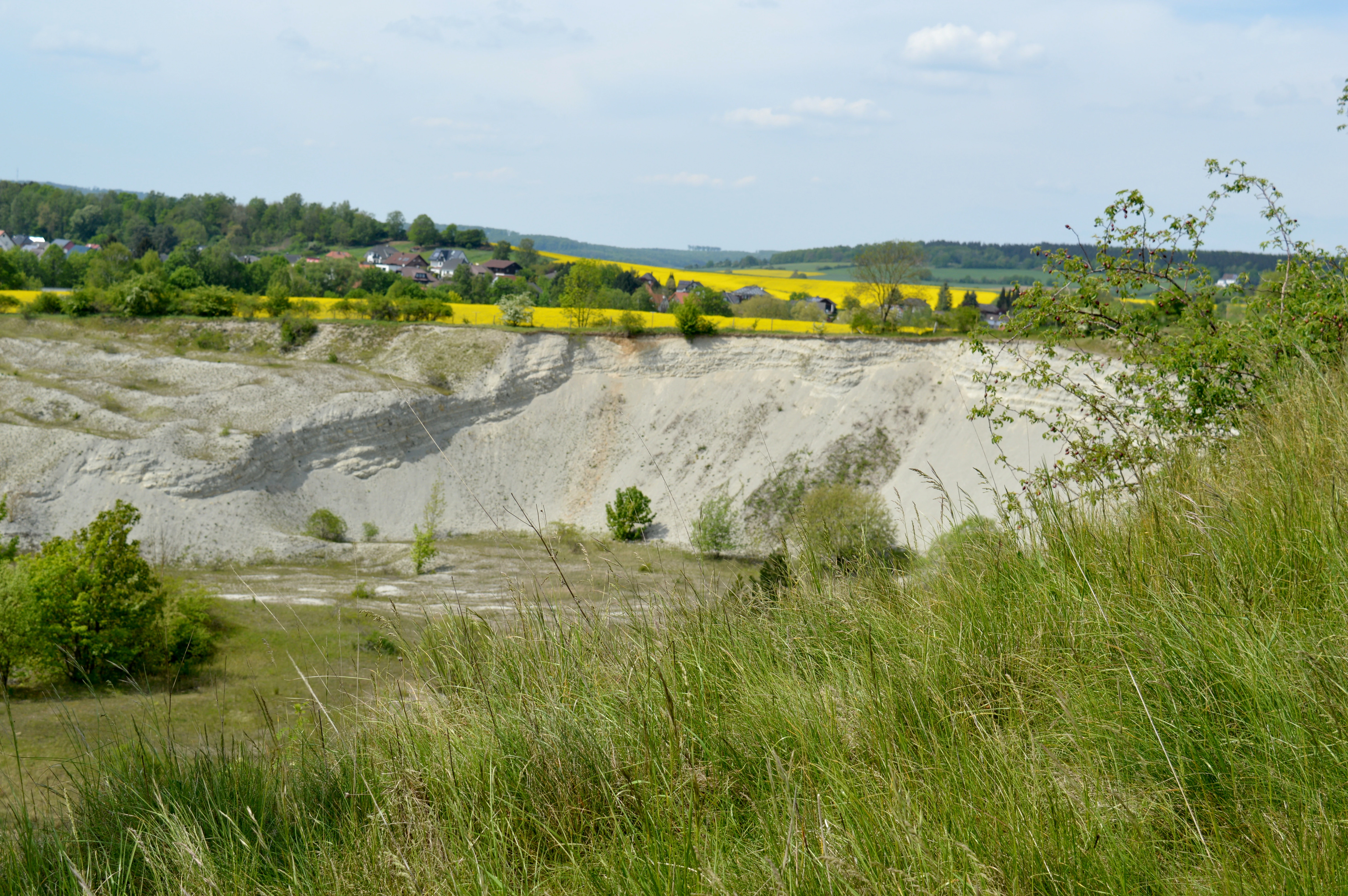
A wide shot of a limestone quarry with light-colored exposed rock faces, grassy foreground, and a field of yellow flowers in the distance.
A view of the limestone quarry landscape at Steinbruch Baddeckenstedt nature reserve.

Steinbruch Baddeckenstedt history and protected-area timeline

The origins of Steinbruch Baddeckenstedt are industrial rather than natural. Roughly until about 1990, the site was actively quarried for limestone and marl, leaving behind steep rock faces, scree slopes, and a deeper excavation that would later fill partially with water. The exact period of earliest extraction is not documented in the source material, but the quarry's working life clearly shaped the topographic character that now defines the reserve.

With extraction ceasing around 1990, the disused quarry entered a long period of passive rewilding. Calcareous rubble accumulated, dry grasslands and ruderal pioneer vegetation began to colonise the warmer microclimates of the south-facing slopes, and a small standing water body developed at the quarry floor. By the early 2000s, these post-industrial habitats had matured enough to support rare plants, notable insects, eagle owls, bats, and amphibians, prompting conservation action.

The site was formally protected on 19 June 2009 by the Untere Naturschutzbehörde of the Wolfenbüttel district, with the designation 'NSG BR 142'. The protection order framed the reserve's purpose explicitly around the preservation, care, and near-natural development of the quarry as habitat for threatened species, institutionalising the ecological recovery that had been underway for nearly two decades.

Steinbruch Baddeckenstedt landscape and geographic character

The landscape of Steinbruch Baddeckenstedt is dominated by the artificial but ecologically compelling topography of a former limestone quarry. The central feature is a roughly forty-metre-high near-vertical rock face, north-east facing in the visible parts and largely stripped of vegetation due to its steepness and exposure. Above and around it, broader quarry floors and benches hold a different kind of terrain: open calcareous rubble slopes where pioneer plants and dry grassland species have taken hold.

Between 110 and 145 metres above sea level, the reserve lies in a gently undulating part of the Innerste-Salzgitter hill country. The quarry sits within the Gemarkung Oelber am weißen Wege, and to the north-east it borders the larger landscape protection area 'Lichtenberg, Oelber Tal, Elberberg-Höhenzug', integrating the small reserve into a wider network of protected landscapes.

The most distinctive visual character of the reserve is the contrast between the bare quarry cliffs and the surrounding shrubby, flower-rich calcareous slopes. This juxtaposition of rock, rubble, and warm, open vegetation gives the small site a strong sense of place despite its limited size.

Steinbruch Baddeckenstedt ecosystems, habitats, and plant life

Ecologically, Steinbruch Baddeckenstedt is defined by its calcareous, sun-exposed substrates and its unusual combination of open rock, dry grassland, pioneer shrubland, and standing water. These features support vegetation types that are generally rare in the intensively farmed and forested landscapes of Lower Saxony, including Magerrasen calcareous dry grasslands and ruderal pioneer communities.

The limestone and marl geology is more than a backdrop: by providing calcareous weathering products, the substrate supports plant communities tied to base-rich soils, while the warm microclimate of south-facing rubble slopes extends the range of species that can thrive here. The site's mosaic of habitats, sometimes spanning only metres, allows dry-site specialists and moisture-dependent amphibians to exist in close proximity.

This juxtaposition, dry cliffs and rubble next to a small pond, is uncommon in the wider region. As a result, the reserve functions as a kind of miniature refugium, where habitat diversity compensates for limited area and supports species that would otherwise struggle in the surrounding agricultural countryside.

Steinbruch Baddeckenstedt wildlife and species highlights

Wildlife at Steinbruch Baddeckenstedt reflects the site's mix of rocky terrain, warm slopes, and standing water. The quarry walls, cliffs, and adjacent cliff-edge vegetation host eagle owls, one of the reserve's most charismatic species, taking advantage of the steep faces and quiet surroundings for breeding and roosting.

A rich insect fauna has been documented here, likely supported by warm microclimates and abundant wildflowers. Among the notable records are the streifenwanze bug and the Jakobskrautbär moth, both highlighted as uncommon insect species in the source material. This insect richness, in turn, is the foundation for bat populations feeding over the quarry and its surroundings.

A separate wildlife axis is provided by the in-quarry pond, which serves as a valuable amphibian breeding habitat. Within a reserve of only a few hectares, the combination of cliff-nesting birds, strong insect communities, foraging bats, and breeding amphibians gives the site a notably high ecological return for its size.

Steinbruch Baddeckenstedt conservation status and protection priorities

The conservation case for Steinbruch Baddeckenstedt rests on the idea of preserving a small but ecologically dense mosaic of calcareous habitats that have developed on former quarry land. By protecting roughly 6.3 hectares of bare rock, dry calcareous grassland, ruderal vegetation, and an in-quarry pond, the reserve safeguards plant and animal communities that are otherwise rare or threatened at regional scale.

Protection was formalised under the Lower Saxony nature conservation framework, with NLWKN oversight providing long-term institutional support. The 2009 protection order explicitly emphasises the preservation, care, and near-natural development of the quarry as habitat for threatened species, highlighting the site's role in the regional network of small but ecologically valuable protected areas.

Beyond strictly ecological considerations, the reserve also has geo-scientific value: the eroded Cretaceous limestone contains frequent fossils around 100 million years old, linking biodiversity conservation with documentation of deep-time geological heritage in a single small site.

Steinbruch Baddeckenstedt cultural meaning and human context

The reserve has limited traditional or indigenous cultural context in the usual sense, but it sits within a region of long-established villages and small administrative units, with the Gemarkung Oelber am weißen Wege providing the local historical framing. The quarry itself is an artefact of twentieth-century industrial activity, and its transformation into a nature reserve reflects a broader shift in regional land-use priorities from resource extraction toward ecological recovery.

Top sights and standout views in Steinbruch Baddeckenstedt

Although the reserve is small in area, its highlights are unusually concentrated. Steep, largely vegetation-free quarry walls rise beside rubble slopes rich in dry grassland and ruderal vegetation, supporting rare plants such as viper's bugloss, fringed gentian, blue lettuce, clasping whitlowgrass, meadow and field gageas, and large speedwell.

Eagle owls breed among the cliffs, an unusually dense insect fauna includes the streifenwanze bug and the Jakobskrautbär moth, bats forage above the quarry, and amphibians use the in-quarry pond. Beneath all of this, the exposed Cretaceous limestone preserves a fossil record dating back around 100 million years.

Best time to visit Steinbruch Baddeckenstedt

Because the reserve is centred on calcareous dry grassland and rocky habitats, late spring and early summer tend to be the most rewarding periods for visiting. Wildflower diversity peaks as dry grassland species such as viper's bugloss, fringed gentian, and blue lettuce come into bloom, and insect activity over the warm rubble slopes is at its highest, supporting both bats and breeding birds.

For those interested in amphibians, mild spring weather is likely to be the most useful time to observe activity around the in-quarry pond. Winter visits, by contrast, emphasise the stark visual character of the bare quarry cliffs, but the biological highlights of the site are largely dormant during the colder months.

Monthly climate preview

Long-term temperature ranges and monthly precipitation averages recorded at reference coordinates

Steinbruch Baddeckenstedt Climate Normals and Annual Weather Patterns

Historical data records monthly temperature variations and precipitation rates across a representative coordinate within Steinbruch Baddeckenstedt from 1991 to 2020. Examining the full twelve-month profile reveals detailed baseline climate trends and long-term environmental averages for the protected area.
Annual mean9 °C
0 °C18 °C
Jan
Feb
Mar
Apr
May13°
Jun16°
Jul18°
Aug18°
Sep14°
Oct
Nov
Dec
Warmest month
July

18.4 °C

Coolest month
January

-0.1 °C

Wettest month
July

2.6 mm/day

Driest month
April

1.4 mm/day

Park location guide

Geography guide, regional context, and park location map for Steinbruch Baddeckenstedt

Steinbruch Baddeckenstedt park geography, regions, and map view in Germany

Understand where Steinbruch Baddeckenstedt sits in Germany through a broader geographic reading of the surrounding landscape, nearby location context, and its mapped position within the national park landscape.

How Steinbruch Baddeckenstedt fits into Germany

Germany is a federal republic in Western and Central Europe with a population of over 83 million across sixteen constituent states. It is Europe's largest economy by nominal GDP and a major global exporter and importer. The capital is Berlin, and the country borders Denmark, Poland, Czech Republic, Austria, Switzerland, France, Luxembourg, Belgium, and the Netherlands.

Wider geography shaping Steinbruch Baddeckenstedt in Germany

Germany is located in Western and Central Europe, spanning 357,022 km². It borders Denmark to the north, Poland and the Czech Republic to the east, Austria and Switzerland to the south, and France, Luxembourg, Belgium, and the Netherlands to the west. The country has coastlines on the Baltic Sea and North Sea to the north, with the Alps located in the southern region.

Map view of Steinbruch Baddeckenstedt

Use this park location map to pinpoint Steinbruch Baddeckenstedt in Germany, understand its exact geographic position, and read its mapped placement within the surrounding landscape more clearly.

Pigeon | © OpenStreetMap contributors

Location context for Steinbruch Baddeckenstedt

Lower SaxonyWolfenbuettel

Visualizing the limestone cliffs, dry grasslands, and protected habitat of the former quarry

Steinbruch Baddeckenstedt Photos and Landscape Scenery

Visual documentation reveals the striking topography of Steinbruch Baddeckenstedt through steep limestone faces and open rubble slopes. Detailed imagery showcases the sparse pioneer vegetation and unique geological character defining this protected natural reserve.

A wide shot of a limestone quarry with light-colored exposed rock faces, grassy foreground, and a field of yellow flowers in the distance.

A green grassy field leads to a red and white limestone quarry cliff face, with a small flowering bush in the foreground.

Park atlas

Compare regional nature reserves and connected conservation terrain in Lower Saxony

Explore Parks Near Steinbruch Baddeckenstedt and Surrounding Protected Landscapes

Browse other parks near Steinbruch Baddeckenstedt to examine similar calcareous habitats and rocky terrain across the surrounding region. Extending the geographic comparison reveals broader patterns in regional park distribution and protected landscape networks.
Nature reserveSalzgitter
About 6.4 km away#1 closest

East

Tagebau Haverlahwiese Nature Reserve: Geography and Protected Area Mapping in Salzgitter

Mapping restored post-industrial landscapes and habitat mosaics.

This protected area in Salzgitter showcases the natural recovery of former ironstone mining lands. Users can examine the spatial arrangement of the 15-hectare mining lake, extensive reedbeds, and dry calcareous grassland slopes. The site remains a vital example of landscape conservation, illustrating how engineered topography provides new niches for amphibians and salt-tolerant plant communities across the Lichtenberge ridge.

Area
2.06 km²
Established
2016
Relief
Upland
Climate
Temperate
Nature reserveLower Saxony
About 14 km away#2 closest

West

Steinberg bei Wesseln Nature Reserve: A Protected Limestone Slope in Lower Saxony

Geographic focus on calcareous grassland and ridge topography

Explore the geography of Steinberg bei Wesseln, a nature reserve in the Hildesheim district of Lower Saxony. This protected area features a steep, south-facing Muschelkalk ridge that supports a rich mosaic of semi-dry grassland and scrub. Its unique microclimate makes it a significant site for understanding habitat conservation within the broader landscape of the German hill country.

Area
0.16 km²
Established
2007
IUCN
IV
A minimalist watercolor painting featuring soft green, yellow, and purple tones depicting a rolling hill landscape with trees and distant hills.
Nature reserveNiedersachsen
About 23 km away#3 closest

West

Haseder Busch, Giesener Berge, Gallberg, Finkenberg Protected Landscape and Map Data

A diverse hill and floodplain ecosystem in Niedersachsen, Germany.

Trace the ecological boundaries and terrain of this expansive nature reserve. The site features a rare convergence of Triassic sedimentary landscapes, including the northernmost calcareous semi-dry grasslands and beech forests in the region, alongside historic floodplain meadows shaped by the Innerste river.

Area
7.42 km²
Established
2019
Nature reserveHildesheim District
About 26 km away#4 closest

Northwest

Wätzumer Tonkuhle Nature Reserve: Geography and Protected Boundaries in Hildesheim District

A restored wetland refuge in the Lower Saxony agricultural landscape

Wätzumer Tonkuhle offers a rare glimpse into secondary wetland succession within the Hildesheim District. This nature reserve features two primary ponds and an extensive fallow corridor along the Alpebach, serving as a critical sanctuary amidst the surrounding intensive farmland of Northern Germany.

Area
0.105 km²
Established
1986
IUCN
IV
Protected landscapeLower Saxony
About 29 km away#5 closest

South

Naturpark Harz (Niedersachsen): Mapped Protected Landscapes and Regional Terrain

Regional geography and protected area boundaries in Lower Saxony

Spanning roughly 790 square kilometers, Naturpark Harz (Niedersachsen) serves as a vital protected area along the western Harz mountains. The park landscape showcases a transition from high-elevation summits like the Wurmberg down to lowland foothills, integrated with a historic system of reservoirs and river valleys that define the regional geography.

Area
790 km²
Established
1960
Water
Major water bodies
Nature reserveLower Saxony
About 29 km away#6 closest

North

Wendesser Moor Nature Reserve: Mapped Wetland Geography and Protected Landscape Context in Lower Saxony

Exploring the peatland mosaic and marsh bird habitats of the Peine district

Wendesser Moor is a significant 63-hectare nature reserve in Lower Saxony, defined by its rare concentration of fen habitats, alder carr, and open peat pools. As a core component of a wider landscape protection zone, it provides essential refuge for threatened bird species. The reserve functions as a critical node in the local watershed, illustrating how small-scale protected peatlands maintain biodiversity in agricultural lowlands.

Area
0.632 km²
Established
1973
IUCN
IV
Relief
Lowland
A soft watercolor illustration of a river winding through a green floodplain with rolling hills in the background.
Nature reserveRegion Hannover
About 32 km away#7 closest

Northwest

Leineaue zwischen Hannover und Ruthe: Protected Floodplain and River Geography

Nature reserve geography and alluvial habitat mapping.

Examine the topographic and hydrological features of the Leineaue zwischen Hannover und Ruthe nature reserve. This atlas entry provides insights into the site's dual-channel river structure, calcareous tufa springs, and fragmented alluvial woodlands that define this significant conservation area near Hannover.

Area
9.678 km²
Established
2007
Relief
Lowland
Scope
Terrestrial
Watercolor illustration of a mountainous landscape with forests and a winding path
National parkLower Saxony
About 33 km away#8 closest

Southeast

Harz National Park: A Mapped Protected Landscape in Lower Saxony's Mountains

Explore geographic boundaries and regional terrain.

Harz National Park is a protected area defined by its unique mountain landscape and extensive forests in Lower Saxony, Germany. This MoriAtlas entry details its geographic scope, allowing for exploration of its mapped boundaries and its place within the regional geography. Understand the terrain, from its highest peaks to its alpine bogs, offering a structured view of this significant protected landscape for atlas-based discovery.

Area
247 km²
Established
2006
IUCN
II
Visitors
4M annual

Common questions about visiting, size, designation, and location context for Steinbruch Baddeckenstedt

Steinbruch Baddeckenstedt FAQs for park facts, access, geography, and protected area context

Find quick answers about Steinbruch Baddeckenstedt, including protected-area facts, park geography, trail and visitor context, and how the park fits into its surrounding country and regional landscape.
MoriAtlas Explorer

Continue Your Protected Areas Search Across the Global Atlas

Deepen your exploration by continuing the structured search for national parks and protected areas worldwide. Utilize the comprehensive filtering capabilities to compare different conservation landscapes and refine your understanding of global park geography. Discover more about the distribution and characteristics of protected natural areas.

Global natural geography