
Mori Atlas logo
Nature reserveStobbertal

A comprehensive look at the riparian corridors, oak-hornbeam woodlands, and wetland mosaics within this unique eastern German landscape

Stobbertal Nature Reserve: Mapping the Protected River Valley Landscapes of Brandenburg, Germany

(Naturschutzgebiet Stobbertal)

Stobbertal encompasses a diverse mosaic of near-natural habitats defined by the 13-kilometer course of the Stöbber river in Brandenburg. This protected area bridges the transition between wet valley floors, alder-ash floodplain forests, and dry calcareous sandy grasslands. By analyzing the intersection of these terrain types and local hydrologic features, this resource provides an essential look at the ecological architecture of the Märkische Schweiz region and its role within European conservation networks.

river valleynature reservedeciduous forestoak-hornbeam woodlandfloodplain forestwetland
A flat-style digital illustration of a mountain valley featuring a winding river, a waterfall cascading down a steep rock face, and pine forests in the foreground and midground.

Stobbertal

Nature reserve

Park overview

Structured park overview, official facts, and landscape profile for Stobbertal

Stobbertal park facts, protected area profile, and essential visitor context

Review the core facts for Stobbertal, including designation, size, terrain, visitor scale, habitats, and operating context in one park-focused overview.

About Stobbertal

Stobbertal is one of the ecologically important nature reserves in the Märkische Schweiz region of Brandenburg. Covering 884 hectares, it traces the valley of the northeastern branch of the Stöbber river from its source area in the Rotes Luch through to the eastern edge of the Märkisch-Oderland district. The reserve sits within the broader Naturpark Märkische Schweiz and is closely connected to the surrounding protected landscape of eastern Brandenburg.

The reserve protects a striking concentration of habitats. Oak-hornbeam woodland dominates much of the valley, complemented by surviving fragments of alder-ash floodplain forest where the river still behaves naturally. Wet tall-herb vegetation thrives in damp sections, while dry, calcareous sandy grassland occupies drier slopes and terraces, demonstrating the contrast between wet and dry environments that characterizes the area.

Water is central to the identity of Stobbertal. The Stöbber river, referred to locally as 'Stobberow' on some East German tourist maps, runs through the valley as a near-natural flowing watercourse. Small settlements such as the Eichendorfer Mühle and Pritzhagener Mühle are the only inhabited places in the protected area, marking a long history of low-intensity human presence within an otherwise wild landscape.

Because of its habitat diversity and its position within the Naturpark Märkische Schweiz, Stobbertal is also recognized under European nature law. It qualifies as a Fauna-Flora-Habitat site under the EU Habitats Directive and lies within the European Bird Protection Area of Märkische Schweiz.

Quick facts and research context for Stobbertal

Stobbertal is an 884-hectare nature reserve in Brandenburg, Germany. It lies within the Landkreis Märkisch-Oderland and forms part of the larger Naturpark Märkische Schweiz. The reserve stretches roughly 13 kilometers from Buckow in the west to the B167 federal road near Altfriedland in the east. It was designated on 12 September 1990 and is protected under the EU Habitats Directive and as part of the EU Birds Directive area Märkische Schweiz.

Protection and recognition

Examining documented designation records and Natura 2000 framework details for Stobbertal.

Stobbertal Protection Status and International Recognition Sources

Stobbertal features recorded protection status alongside imported Natura 2000 recognition framework entries for conservation analysis. Designated source data outlines official administrative designations and verified international database records.
Park context

Deeper park guide and search-rich context for Stobbertal

Stobbertal history, landscape, wildlife, and travel context

Explore Stobbertal through its history, landscape character, ecosystems, wildlife, conservation priorities, cultural context, and seasonal travel timing in a structured park guide built for atlas discovery and search intent.

Why Stobbertal stands out

The reserve is best known for preserving a richly varied mosaic of old forest and wetland habitats along the Stöbber river. It contains near-natural oak-hornbeam woodland, remnant floodplain forest, wet tall-herb vegetation, calcareous sandy grassland, and a near-natural flowing stream system, all in a relatively compact valley landscape. Stobbertal is also notable for its range of protected and rare species, including the Eurasian beaver, European otter, middle spotted woodpecker, common crane, and Eurasian kingfisher, as well as aquatic species such as the freshwater pearl mussel and the European pond turtle.
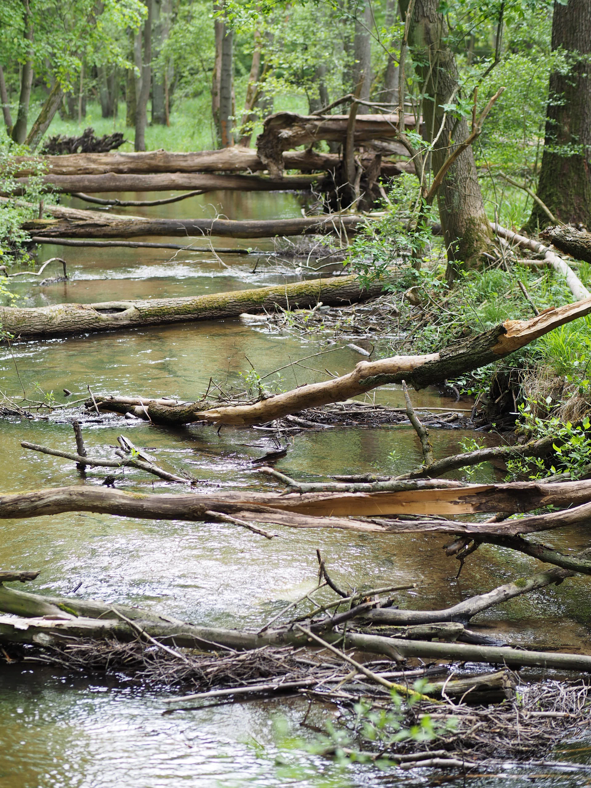
A calm, shallow river flowing through a lush green forest with multiple fallen trees and branches partially submerged in the water.
The Stöbber river flowing through the dense forest of the Stobbertal nature reserve.

Stobbertal history and protected-area timeline

Stobbertal was formally designated as a nature reserve on 12 September 1990, just before German reunification, through a decree issued by the Ministerrat (Council of Ministers) of the German Democratic Republic. The decree simultaneously established the protected areas and a central landscape protection area that together make up the Naturpark Märkische Schweiz.

The valley takes its name from the Stöbber river, which has been spelled 'Stöbber' on most official maps since the late 19th and early 20th century, although East German tourist maps occasionally rendered the name as 'Stobberow'. This variation helps explain the slight vowel difference between the river's modern name and the valley's older name.

Following the administrative changes in Germany after 1990, Stobbertal became part of the Brandenburg state system of protected areas. It was later incorporated into the EU Natura 2000 network as a Fauna-Flora-Habitat site and as part of the European Bird Protection Area Märkische Schweiz. The conservation foundation Euronatur has been supporting the management of 174 hectares within the reserve.

Stobbertal landscape and geographic character

The landscape of Stobbertal is shaped by the meandering course of the Stöbber river, which rises in the Rotes Luch wetland to the south and flows northeastward through a narrow valley. The valley floor is interrupted by small cascades, mill ponds, and characteristic natural features such as the large kettle pond known as the Großer Barschpfuhl, which in spring is edged by blooming cottongrass.

Forests cling to the slopes and terraces of the valley, with mature oak-hornbeam woodland predominating on the mesic soils. Along the river itself, small relict patches of alder-ash floodplain forest survive where the water regime has remained intact. Higher and drier parts of the landscape open into patches of dry, calcareous sandy grassland, marking a sharp transition from wet valley to drier upland habitats.

The reserve stretches approximately 13 kilometers from Buckow in the west to the area around the Karlsdorfer Teiche and the B167 federal road near Altfriedland in the east. Small historical mill settlements, the Eichendorfer Mühle and the Pritzhagener Mühle, anchor the valley's quiet rural character.

Stobbertal ecosystems, habitats, and plant life

Stobbertal preserves a distinctive mix of forest, wetland, and open grassland habitats in a single valley system. The dominant habitat is oak-hornbeam woodland, a classic Central European forest community that thrives on moderately moist soils and typically supports a rich understory of spring ephemerals and shade-tolerant herbs.

Fragmentary alder-ash floodplain forest remains along the Stöbber river where seasonal flooding continues to shape the vegetation. Wet tall-herb communities occupy damp clearings and river margins, producing dense, flower-rich vegetation in summer. On drier, lime-rich sandy soils, calcareous sandy grassland hosts specialized flora.

The Stöbber itself functions as a near-natural flowing watercourse, an increasingly rare habitat type in central Europe. The combination of mature deciduous woodland, floodplain remnants, wet tall-herb vegetation, dry sandy grassland, and a clean running stream gives Stobbertal unusually high ecological diversity within a relatively compact area. Euronatur supports management on 174 hectares of the reserve, helping to maintain these habitats.

Stobbertal wildlife and species highlights

The wildlife of Stobbertal reflects the diversity of its habitats. Mammals include the Eurasian beaver and the European otter, both of which depend on clean watercourses and intact riparian habitat. Bats such as the Brandt's bat and the barbastelle also occur in the reserve, along with the water shrew, a small mammal tied closely to freshwater environments.

The birdlife is particularly notable. The reserve supports species such as the common snipe, the common crane, the Eurasian kingfisher, the grey wagtail, the common goldeneye, and the middle spotted woodpecker, a woodpecker associated with old deciduous woodland. Because Stobbertal lies within the European Bird Protection Area Märkische Schweiz, it contributes to the conservation of these species at a continental scale.

The river and ponds host a diverse aquatic fauna, including the freshwater pearl mussel, the bitterling, the common dace, the gudgeon, the European fire-bellied toad, the weather loach, and the spined loach, as well as the European pond turtle. Among insects, the dragonfly species known as the common clubtail is considered especially worthy of protection and has been incorporated into the logo of the Naturpark Märkische Schweiz.

Rare spring-flowering plants such as liverleaf, wood anemone, lungwort, and yellow wood anemone also occur, contributing to the valley's rich botanical character.

Stobbertal conservation status and protection priorities

Stobbertal carries multiple layers of conservation protection. It was first designated as a nature reserve on 12 September 1990 under the GDR's central decree establishing the Naturpark Märkische Schweiz, and it was retained as a formal nature reserve under Brandenburg state law after reunification.

At the European level, the reserve is protected as a Fauna-Flora-Habitat site under Directive 92/43/EEC, the EU Habitats Directive, and forms part of the EU Birds Directive area Märkische Schweiz. These designations reflect the valley's importance for habitat types such as oak-hornbeam woodland, calcareous sandy grassland, and near-natural flowing water, as well as for species such as the beaver, otter, and middle spotted woodpecker.

Conservation management is supported by the international foundation Euronatur, which contributes to the stewardship of 174 hectares of the reserve. This combination of national and European protection and active third-sector involvement underscores Stobbertal's role as a key component of the Märkische Schweiz conservation landscape.

Top sights and standout views in Stobbertal

Stobbertal stands out as a compact valley that compresses an unusually full range of habitats into a single, easily understood landscape: oak-hornbeam woodland, alder-ash floodplain remnants, wet tall-herb vegetation, calcareous sandy grassland, and a near-natural river course. The presence of two historic mill settlements within the reserve highlights the area's long, low-intensity agricultural history.

The reserve also functions as a strong node within a larger European ecological network. Its status under both the EU Habitats Directive and the EU Birds Directive, and its inclusion in the Naturpark Märkische Schweiz, give it significance that extends well beyond its local footprint.

Monthly climate preview

Long-term temperature and precipitation averages recorded at benchmark coordinates in Brandenburg

Stobbertal Climate Normals and Representative Monthly Temperature Rhythms

Representative coordinate measurements reveal consistent monthly variations in temperature and precipitation across Stobbertal from 1991 to 2020. Examining the complete twelve-month record clarifies long-term regional climate normals and multi-year meteorological patterns.
Annual mean9 °C
-1 °C20 °C
Jan-1°
Feb
Mar
Apr
May14°
Jun18°
Jul20°
Aug20°
Sep15°
Oct
Nov
Dec
Warmest month
July

20.3 °C

Coolest month
January

-1.1 °C

Wettest month
July

2.5 mm/day

Driest month
April

1.1 mm/day

Park location guide

Geography guide, regional context, and park location map for Stobbertal

Stobbertal park geography, regions, and map view in Germany

Understand where Stobbertal sits in Germany through a broader geographic reading of the surrounding landscape, nearby location context, and its mapped position within the national park landscape.

How Stobbertal fits into Germany

Germany is a federal republic in Western and Central Europe with a population of over 83 million across sixteen constituent states. It is Europe's largest economy by nominal GDP and a major global exporter and importer. The capital is Berlin, and the country borders Denmark, Poland, Czech Republic, Austria, Switzerland, France, Luxembourg, Belgium, and the Netherlands.

Wider geography shaping Stobbertal in Germany

Germany is located in Western and Central Europe, spanning 357,022 km². It borders Denmark to the north, Poland and the Czech Republic to the east, Austria and Switzerland to the south, and France, Luxembourg, Belgium, and the Netherlands to the west. The country has coastlines on the Baltic Sea and North Sea to the north, with the Alps located in the southern region.

Map view of Stobbertal

Use this park location map to pinpoint Stobbertal in Germany, understand its exact geographic position, and read its mapped placement within the surrounding landscape more clearly.

Pigeon | © OpenStreetMap contributors

Location context for Stobbertal

Brandenburg

Explore detailed imagery of oak-hornbeam woodland, wetlands, and meandering valley waters.

Stobbertal Landscape Photos and Scenery: Visualizing the Protected River Valley

Visual documentation captures the varied terrain, native habitats, and protected ecosystems defining the Stobbertal river valley. Examining these field photographs reveals the close interplay between mature deciduous forests, wetland patches, and natural watercourses across the Brandenburg landscape.

A calm, shallow river flowing through a lush green forest with multiple fallen trees and branches partially submerged in the water.

A forest scene in Stobbertal featuring numerous slender, light-barked trees and a ground layer densely covered with white-flowering cotton grass and green moss.

Park atlas

Compare regional valley reserves and connected woodland ecosystems

Explore Protected Areas and Parks Near Stobbertal in Brandenburg

Browse other protected areas and nature reserves located near Stobbertal across the Brandenburg region. Continuing the geographic comparison reveals broader ecological patterns across neighboring river valleys and forest habitats.
A horizontal watercolor painting showing layers of soft-toned hills in green and purple, with tall blades of grass in the foreground.
Nature reserveBrandenburg
Park boundaries overlap#1 closest

Southwest

Klobichsee Nature Reserve: Protected Landscape and Glacial Lake Geography in Brandenburg

Mapping aquatic ecosystems and protected boundaries in eastern Germany

Klobichsee Nature Reserve covers roughly 5.59 square kilometers, centering on the Großer Klobichsee and Kleiner Klobichsee glacial lakes. This protected area in Brandenburg preserves essential forest and wetland habitats, maintaining the ecological character of the region situated between Buckow and Münchehofe.

Area
5.59 km²
Established
1990
IUCN
IV
Climate
Temperate
A soft watercolor painting of a pastoral landscape featuring green rolling hills, distant trees, and a foreground with grassy vegetation and pinkish marsh-like reflections.
Protected landscapeBrandenburg
About 0 km away#2 closest

West

Naturpark Märkische Schweiz: A Protected Landscape Discovery in Brandenburg

Glacial terrain, kettle lakes, and river basin geography.

Situated near Berlin, this protected landscape features a textbook glacial relief shaped by retreating ice sheets. The area encompasses the Schermützelsee, deep kettle ponds known as Sölle, and the narrow valleys of the Stobber river. Learn about the park's layered conservation framework, which combines European habitat protection with rich fieldstone architecture and cultural history.

Area
205 km²
Established
1990
Relief
Upland
Climate
Temperate
Watercolor painting of a tranquil, flat wetland landscape with pale green, pink, and yellow hues representing water, vegetation, and a soft sky.
Nature reserveBrandenburg
About 0.9 km away#3 closest

Northeast

Europäisches Vogelschutzgebiet Altfriedländer Teich- und Seengebiet: Protected Area Geography

Nature reserve wetland network in eastern Brandenburg

Discover the geographic structure of this extensive pond and lake complex in Märkisch-Oderland. This protected area features shallow open water, sprawling reedbeds, and remnants of lowland peat that support dense populations of migratory waterfowl and rare breeding waterbirds within a working cultural landscape.

Area
7 km²
Relief
Lowland
Climate
Temperate
Scope
Terrestrial
Protected landscapePoland
17 km away#4 closest

Northeast

Park Krajobrazowy Ujście Warty: Protected Landscape and River Valley Atlas

Mapping wetland ecosystems and floodplain geography in western Poland

Park Krajobrazowy Ujście Warty preserves a significant lowland river valley landscape characterized by vast open pastures, marshes, and rare riparian oak forests. Located primarily within the Lubuskie region, this protected area offers a clear view into the floodplain processes of the Warta river basin, providing a distinct geographic context for wetland conservation and waterbird habitat mapping in Poland.

Area
194.96 km²
Established
1996
Relief
Lowland
Climate
Temperate
A horizontal watercolor painting showing a soft-focus landscape of light green trees, yellow fields, and pale blue rolling hills in the background.
Nature reserveBrandenburg
About 18 km away#5 closest

West

Lange Dammwiesen und Unteres Annatal: Glacial Ridges and Nature Reserve Geography

A mapped protected area in the state of Brandenburg, Germany

Lange Dammwiesen und Unteres Annatal represents a compact but ecologically rich nature reserve featuring signature osar ridges and varied meadow habitats. This site provides valuable insight into the glacial landscape of the North German Plain, illustrating the effectiveness of conservation grazing in maintaining diverse ecosystems within the Brandenburg region.

Area
0.013 km²
Established
1990
IUCN
IV
Relief
Lowland
Protected landscapeWest Pomeranian Voivodeship
18 km away#6 closest

North

Cedynia Landscape Park: Mapped Protected Landscapes and Regional Geography in Poland

Protected mosaic of sandy forests and river valleys

Spanning 308 square kilometers, Cedynia Landscape Park protects a complex transition zone in Poland. The area features the expansive Puszcza Piaskowa pine forests, the hilly moraine relief of the Cedynia Carpathians, and the biodiverse wetlands of the lower Oder River. This protected landscape represents an essential study in lowland ecological gradients and postglacial terrain development within the West Pomeranian Voivodeship.

Area
308.5 km²
Established
1993
Relief
Upland
Climate
Temperate
A horizontal watercolor illustration showing soft, pastel-colored rolling hills and a calm lake or pond in the foreground, surrounded by grassy banks.
Nature reserveBrandenburg
About 22 km away#7 closest

South

Beerenbusch Nature Reserve: Geographic Profile and Protected Woodland Landscapes of Brandenburg

Mapping forest boundaries in the German lowlands

Located in the Oder-Spree district, Beerenbusch protects rare oak-hornbeam and alder swamp forest ecosystems. This profile details the reserve landscape, cultural landmarks like the Königskiefer, and its importance as a surviving woodland refuge within the Brandenburg forest belt.

Area
0.7 km²
Established
1967
IUCN
IV
Relief
Lowland
Nature reserveBrandenburg
25 km away#8 closest

North

Tongruben Neuenhagen Nature Reserve: Protected Wetland Geography in Brandenburg, Germany

Examining post-industrial clay-pit habitats and protected wetland boundaries

Tongruben Neuenhagen is a designated nature reserve located in Brandenburg, Germany, established to protect biological communities that have developed within former clay extraction pits. The area features a complex mosaic of open water, wetland margins, and transitional scrub habitats. This reserve provides a notable example of how historical industrial land use can be repurposed into valuable habitat for protected species, serving as a key element of the local conservation network in the Märkisch-Oderland region.

Area
1.196 km²
Established
1990
IUCN
IV
Relief
Lowland

Common questions about visiting, size, designation, and location context for Stobbertal

Stobbertal FAQs for park facts, access, geography, and protected area context

Find quick answers about Stobbertal, including protected-area facts, park geography, trail and visitor context, and how the park fits into its surrounding country and regional landscape.
MoriAtlas Explorer

Continue Your Protected Areas Search Across the Global Atlas

Deepen your exploration by continuing the structured search for national parks and protected areas worldwide. Utilize the comprehensive filtering capabilities to compare different conservation landscapes and refine your understanding of global park geography. Discover more about the distribution and characteristics of protected natural areas.

Global natural geography