
Mori Atlas logo
Nature reserveStubbe Sø

Examining the ecological mosaic of lakes, mire systems, and coniferous forest margins.

Stubbe Sø Nature Reserve: A Detailed Atlas of Protected Landscapes in Region Midtjylland

(Natura 2000-område nr. 48 Stubbe Sø)

Stubbe Sø represents a significant protected area within Region Midtjylland, functioning as the largest lake on the Djursland peninsula. This nature reserve preserves a distinctive landscape characterized by shallow nutrient-rich waters, surrounding mire systems, and dense coniferous forests. Through structured geographic observation, visitors can trace the boundaries of this vital wetland habitat that serves as a staging ground for extensive waterbird populations.

lakewetlandbird sanctuaryNatura 2000national parkconiferous forest
A flat-style digital illustration of a calm lake surrounded by rolling hills and grassy banks under a soft, golden sun.

Stubbe Sø

Nature reserve

Park overview

Structured park overview, official facts, and landscape profile for Stubbe Sø

Stubbe Sø park facts, protected area profile, and essential visitor context

Review the core facts for Stubbe Sø, including designation, size, terrain, visitor scale, habitats, and operating context in one park-focused overview.

About Stubbe Sø

Stubbe Sø occupies a central place in the wetland and lake landscape of Djursland, the peninsula that juts eastward into the Kattegat in central Denmark. With a surface area of around 376 hectares, it is the largest lake on Djursland and the third largest in Jutland. The lake itself accounts for roughly half of the 778-hectare Natura 2000 site that bears its name, the remainder being a surrounding belt of mire, freshwater meadow, heath, stream, and forest.

The lake is shallow and nutrient-rich, conditions that make it productive for aquatic life and attractive to large numbers of waterbirds. Geologically and historically, Stubbe Sø is a relict of a former fjord that once extended from the Kattegat coast near Dråby Strand inland across what is now low-lying terrain. Over time the fjord was cut off from the sea, leaving the present lake, which still drains eastward into the Kattegat via the Havmølle Å stream.

The character of the surrounding landscape has been substantially altered by human activity. Originally the lake was a heath lake, set among open heather-covered hills. Subsequent afforestation converted most of the visible landscape into dark stands of conifer, while a narrower, lighter fringe of alder and birch persists along the lakeshore. Despite these changes, the lake and its associated wetland habitats remain among the most important freshwater bird sites in the region, attracting breeding birds, staging migrants, and wintering flocks.

From a governance and conservation perspective, Stubbe Sø is part of Nationalpark Mols Bjerge and is protected through multiple layers of European and Danish law. It is formally registered as an EU Natura 2000 habitat area and, together with the uplands of Mols Bjerge to the southwest, contributes to one of the most significant protected landscape complexes in central Denmark.

Quick facts and research context for Stubbe Sø

Stubbe Sø is the largest lake on the Djursland peninsula and the third largest in Jutland, with the open water covering roughly 376 hectares. The broader protected area covers 778 hectares in Syddjurs Kommune, within Region Midtjylland in central eastern Denmark.

The site is an EU Natura 2000 habitat area (no. 48) and is part of Nationalpark Mols Bjerge. About 440 hectares of the total area fall under section 3 of the Danish Nature Protection Act, including lake, mire, freshwater meadow, heath, and 3.5 km of watercourse, while the remaining forest is dominated by conifers planted over former heathland.

Protection and recognition

Terrestrial conservation scope and documented Natura 2000 recognition details

Stubbe Sø Protection Status and Official International Recognition Data

Stubbe Sø holds documented terrestrial protection status supported by formal Natura 2000 recognition sources. Terrestrial conservation records outline official designation boundaries without assuming management effectiveness.

International recognition

Protection details

Protection scope
Terrestrial
Transboundary protection
No
Park context

Deeper park guide and search-rich context for Stubbe Sø

Stubbe Sø history, landscape, wildlife, and travel context

Explore Stubbe Sø through its history, landscape character, ecosystems, wildlife, conservation priorities, cultural context, and seasonal travel timing in a structured park guide built for atlas discovery and search intent.

Why Stubbe Sø stands out

Stubbe Sø is best known as a major waterbird site on Djursland, particularly valued as a staging and resting area for large flocks of geese, ducks, grebes, and mergansers that concentrate on its shallow, nutrient-rich waters. It is also recognized for its setting as a former fjord lake now embedded in a mosaic of coniferous plantations, mire, and alder-birch shoreline woodland, all within the broader landscape of Nationalpark Mols Bjerge.
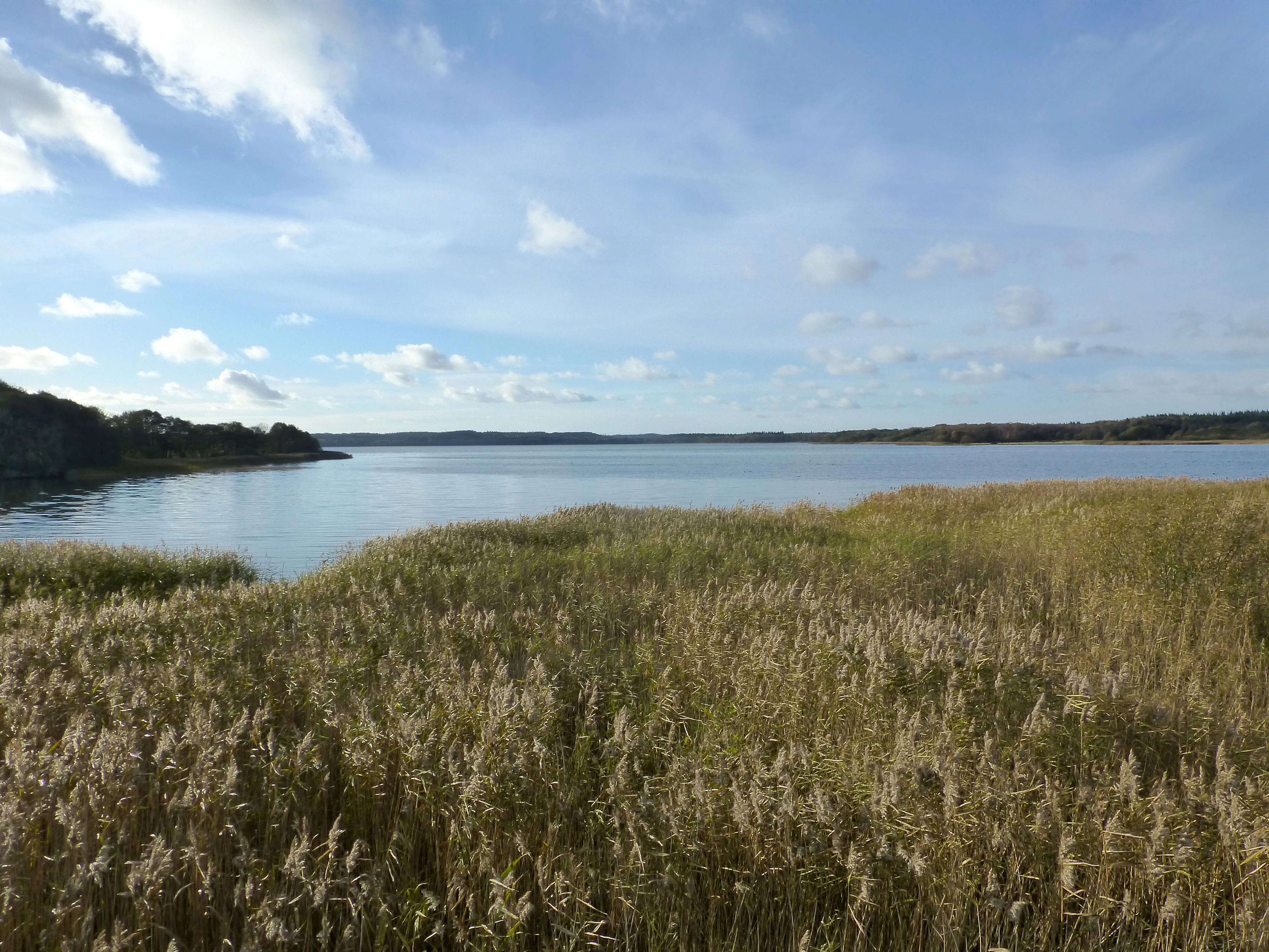
A wide, eye-level landscape view of a calm lake surrounded by reeds and distant trees under a partly cloudy sky.
A view across the calm waters of Stubbe Sø, the largest lake on the Djursland peninsula in Denmark.

Stubbe Sø history and protected-area timeline

Human shaping of the Stubbe Sø landscape goes back at least to the closure of the original fjord system and the gradual transformation of the surrounding heath into farmland and forest, but the modern protective history of the area begins in the twentieth century. In 1963, Stubbe Sø and surrounding lands totaling 381 hectares were placed under a nature conservation order to protect their landscape values.

The Danish nature conservation organization Fugleværnsfonden acquired a 23-hectare bird reserve on the northeastern side of the lake, which remains publicly accessible and continues to play a role in managing disturbance around important waterbird habitat. The reserve sits within a broader pattern of formal protection that has accumulated over the following decades.

In 2011, the first Natura 2000 plan for the site was adopted, requiring Syddjurs Kommune and Naturstyrelsen to draw up binding action plans for its implementation. The plan was coordinated with the water plan for the Djursland catchment and has since been extended and refined in subsequent planning periods. The inclusion of Stubbe Sø within Nationalpark Mols Bjerge has further integrated the lake into a larger framework of landscape-scale protection and management in central Djursland.

Stubbe Sø landscape and geographic character

Stubbe Sø sits in a gentle, low-lying terrain of lakes and mires northeast of the more pronounced uplands of Mols Bjerge. This part of Djursland consists of broad, shallow valleys and basins shaped by glacial processes and historically influenced by the sea, which once penetrated inland through a fjord that has since become the present lake.

The lake itself is large and shallow, with an open expanse of water that reflects the surrounding forest and sky. Along its margins, a narrow, lighter zone of alder and birch gives way abruptly to the darker stands of coniferous forest that now cover most of the visible landscape. This contrast between the open, light-fringed shoreline and the dense, dark plantations is one of the defining visual character traits of the area.

Around and beyond the forest, the landscape includes mires, freshwater meadows, and patches of dry heath on the older sandy and gravelly soils left by glacial activity. Together with the lake, these features create the varied wetland-mire-edge mosaic typical of this part of eastern Jutland.

Stubbe Sø ecosystems, habitats, and plant life

The ecological character of Stubbe Sø is defined by the combination of a shallow, nutrient-rich lake with mires, freshwater meadows, stream corridors, and extensive surrounding forest. The lake supports aquatic vegetation typical of nutrient-rich Danish lowland lakes, and it is bordered by alder-birch swamp woodland in the wettest shoreline zones.

The Natura 2000 designation for the site lists a range of natural habitat types that the management plan aims to maintain in favorable condition. These include hard-water charophyte lake habitat, nutrient-rich lake habitat, watercourses, dry acidic grassland, periodically inundated meadows, and rich fens. Forest habitats of particular concern include beech forest on mor soils, oak mixed woodland, pedunculate oak scrub, and alder-ash swamp forest.

Mire and bog habitats are a special focus of the conservation strategy for the area, with the stated objective of safeguarding existing raised bogs, achieving a high state of conservation for them, and expanding them where natural conditions allow. The mosaic of open water, marshy fringes, and forested slopes creates a diverse habitat gradient that supports a wide range of breeding, staging, and wintering species.

Stubbe Sø wildlife and species highlights

Stubbe Sø is primarily significant for its waterbirds. The lake is an important breeding site and, more importantly, a major staging and resting area for large flocks of geese, ducks, grebes, and mergansers that use its shallow, productive waters. The combination of open water and sheltered shoreline makes it attractive to a wide variety of species throughout much of the year.

Raptors are regularly observed around the lake, with white-tailed eagles and ospreys among the more notable visitors that take advantage of the fish-rich waters and the open sightlines over the surrounding landscape. The mix of open water, marsh, and forest edge provides a range of hunting opportunities for different predator species.

Among mammals, otter has been recorded around the outflow of the lake into Havmølle Å, reflecting the connectivity of the lake and stream system and the importance of intact shoreline habitats for this species. The combination of protected aquatic habitat and adjacent mire and forest contributes to the broader fauna of the Nationalpark Mols Bjerge landscape.

Stubbe Sø conservation status and protection priorities

Stubbe Sø is protected at multiple levels. Nationally, the lake and surrounding land were placed under a nature conservation order in 1963 to protect their landscape values. A 23-hectare bird reserve on the northeastern shore, owned by Fugleværnsfonden, provides additional protection and manages public access in sensitive areas.

At the European level, the area is designated as EU Natura 2000 habitat area number 48, with a collection of priority and non-priority habitat types listed in its formal designation. A Natura 2000 plan adopted in 2011 set binding actions for Syddjurs Kommune and Naturstyrelsen, with particular emphasis on securing raised bogs in good condition and expanding them where natural conditions allow.

The site also lies within Nationalpark Mols Bjerge, integrating Stubbe Sø into one of the most significant landscape-scale conservation frameworks in Denmark. Together these instruments aim to preserve the lake's value for waterbirds, maintain the mire, meadow, and forest habitats in favorable condition, and coordinate land and water management across the broader Djursland catchment.

Stubbe Sø cultural meaning and human context

Stubbe Sø is fundamentally a natural rather than cultural site, but it sits within a landscape that has been shaped over centuries by rural land use. The original heath environment around the lake was historically used for grazing and other low-intensity activity, and the later conversion of much of the heath to coniferous plantation reflects broader twentieth-century patterns of Danish afforestation.

The lake and its conservation history are also part of the identity of Djursland and of the broader Mols Bjerge region, where long-standing local interest in landscape and wildlife protection contributed to the establishment of both the 1963 conservation order and the later national park. Public access to the bird reserve and the surrounding protected landscape reflects an established Danish tradition of using such areas for quiet recreation and birdwatching.

Top sights and standout views in Stubbe Sø

Stubbe Sø stands out as the largest lake on Djursland and one of the most important freshwater bird sites in central eastern Denmark, with a particular reputation for large gatherings of geese, ducks, grebes, and mergansers.

Its setting within Nationalpark Mols Bjerge and its dual status as a long-protected landscape and an EU Natura 2000 habitat area give it both a strong conservation identity and a wider role in the protection of the surrounding heath, mire, and forest landscapes.

Best time to visit Stubbe Sø

The character of a visit to Stubbe Sø varies with the seasons. Late autumn, winter, and early spring are typically the most rewarding periods for waterbird viewing, when large numbers of geese, ducks, grebes, and mergansers use the lake as a staging or wintering area, and raptors such as white-tailed eagles and ospreys may be encountered more frequently around the open water.

Spring and early summer bring breeding activity on the lake and in the surrounding wetlands, as well as fresh green growth in the alder-birch shoreline fringe, contrasting with the darker coniferous forest that dominates the wider landscape. Midsummer tends to be quieter for large flocks but offers the most pleasant conditions for exploring the surrounding woodland and mire edges.


Monthly climate preview

Examine long term weather by month variations across representative regional coordinates

Stubbe Sø Climate Normals: Measured Annual Temperature and Precipitation Rhythm

Long term temperature and precipitation measurements illustrate the recorded annual climate rhythm across representative coordinates within Stubbe Sø. Reviewing the complete twelve month profile provides deeper analytical context for monthly weather patterns and historical averages.
Annual mean9 °C
1 °C17 °C
Jan
Feb
Mar
Apr
May11°
Jun15°
Jul17°
Aug17°
Sep14°
Oct10°
Nov
Dec
Warmest month
August

17.1 °C

Coolest month
February

1.2 °C

Wettest month
October

2.7 mm/day

Driest month
April

1.5 mm/day

Park location guide

Geography guide, regional context, and park location map for Stubbe Sø

Stubbe Sø park geography, regions, and map view in Denmark

Understand where Stubbe Sø sits in Denmark through a broader geographic reading of the surrounding landscape, nearby location context, and its mapped position within the national park landscape.

How Stubbe Sø fits into Denmark

Denmark is a constitutional monarchy and Nordic country in Northern Europe. It is the southernmost of the Scandinavian countries, bordering Germany to the south, Norway to the north, and Sweden to the southwest. The country consists of the Jutland peninsula and an archipelago of islands, with Copenhagen as its capital and largest city. Denmark has a population of over 6 million and is characterized by flat, arable land, sandy coasts, and a temperate climate.

Wider geography shaping Stubbe Sø in Denmark

Denmark occupies the Jutland peninsula and roughly 406 islands in Northern Europe. It is situated between the North Sea to the west and the Baltic Sea to the east. The country borders Germany to the south and is connected to Sweden via the Øresund Bridge. Denmark is predominantly flat terrain with low elevation, the highest point being Møllehøj at 170.86 meters.

Map view of Stubbe Sø

Use this park location map to pinpoint Stubbe Sø in Denmark, understand its exact geographic position, and read its mapped placement within the surrounding landscape more clearly.

Pigeon | © OpenStreetMap contributors

Location context for Stubbe Sø

Region Midtjylland
Recorded earthquake history

Examine Historical Earthquake Records and Seismic Data for Stubbe Sø

Investigate the historical catalogue of seismic events recorded in the vicinity of Stubbe Sø. MoriAtlas provides a clear, data-driven perspective on past activity to support a deeper geographic understanding of this Djursland protected landscape.

Stubbe Sø Earthquake History

Catalogued events

3 events

Strongest magnitude

Magnitude 3.2

Most recent event

Feb 3, 2005

This history includes earthquakes recorded inside the park or within 50 km of its borders

Explore protected area views, lake scenery, and forest terrain across Djursland

Stubbe Sø Photos and Landscapes: Visualizing the Protected Habitats

Visual records capture the open waters, shoreline wetlands, and surrounding coniferous forest that define Stubbe Sø. Examining protected area imagery provides clear insight into the complex terrain and vital bird habitats preserved within Nationalpark Mols Bjerge.

A wide, eye-level landscape view of a calm lake surrounded by reeds and distant trees under a partly cloudy sky.

Park atlas

Compare regional wetlands, forests, and protected areas across eastern Jutland

Explore Parks Near Stubbe Sø and Connected Protected Landscapes

Browsing parks near Stubbe Sø reveals connected wetland habitats, shallow lakes, and forested lowland terrain across the Djursland peninsula. Extending geographic comparison helps trace broader protected-area patterns and regional conservation landscapes throughout eastern Denmark.
Watercolor illustration showing rolling hills, a lake, pink flowering trees, and distant mountains
National parkDenmark
Park boundaries overlap#1 closest

Southwest

Mols Bjerge National Park: Glacial Geography and Protected Terrain in Central Jutland

Mapping the coastal cliffs and rolling heathland of Denmark

Mols Bjerge National Park protects a sweeping mosaic of glacial hills, woodlands, and coastal zones on the Djursland peninsula. With a landscape shaped by ancient ice sheets, the park offers a detailed view into Denmark's geological history, preserved ancient barrows, and rich botanical diversity along the Kattegat sea.

Area
180 km²
Established
2009
IUCN
II
Relief
Upland
Watercolor painting of a panoramic landscape featuring green rolling hills, light foliage, and patches of pink wildflowers in the foreground.
National parkCentral Jutland
About 8.7 km away#2 closest

West

Nationalpark Mols Bjerge: A Geographic Overview of Central Jutland's Glacial Landscape

Mapped terrain, dead-ice hills, and prehistoric monuments

Nationalpark Mols Bjerge offers a deep look into the glacial heritage of Central Jutland. The area features steep, sun-exposed slopes, heathland, and coastal fringes that provide a unique perspective on the Danish landscape. By examining the park's mapped boundaries, one can identify the convergence of geological landforms and ancient cultural history preserved within this protected environment.

Relief
Mountain
Access
Easy access
Water
Major water bodies
A horizontal watercolor illustration showing a calm coastal bay with grassy banks, winding water channels, and rolling hills in the background under a soft yellow sky.
Protected areaRegion Midtjylland
About 14 km away#3 closest

Southwest

Natura 2000-område nr. 51 Begtrup Vig og kystområder ved Helgenæs Geography and Maps

Coastal grasslands and marine habitats in Region Midtjylland

Examine the complex terrain of Natura 2000-område nr. 51 Begtrup Vig og kystområder ved Helgenæs, an expansive protected area characterized by its diverse coastal cliff systems and large calcareous grasslands. This site documents the evolution of the Kattegat shoreline through its unique recurved spits and lifted seabed formations, providing a window into the natural landscape history of the Helgenæs peninsula.

Area
17.71 km²
Established
2011
Relief
Lowland
Climate
Temperate
Nature reserveRegion Midtjylland
14 km away#4 closest

West

Tved Kær Nature Reserve: Protected Coastal Habitat Geography in Region Midtjylland

Exploring lime-rich fens and coastal cliff terrain.

Tved Kær represents a compact but ecologically dense protected area in Denmark, known for its rare calcareous fen and seepage vegetation. Situated near the village of Tved, this nature reserve integrates coastal cliffs and raised seabed to form a distinct habitat mosaic within the Mols peninsula, serving as a vital site for rare orchid species and lime-rich soil preservation.

Area
0.06 km²
Established
1981
Relief
Lowland
Climate
Temperate
Watercolor painting of a calm coastal bay with soft, layered green hills in the distance and a pale shoreline in the foreground.
Protected areaDenmark
About 15 km away#5 closest

Southwest

Begtrup Vig Protected Area: Glacial Terrain and Coastal Geography in Denmark

Coastal landscape and regional protected area mapping

Begtrup Vig is a distinct coastal bay defined by its glacial history, stretching across the southern Djursland peninsula in Denmark. Within the broader Mols Bjerge national park framework, the area features varied topography including stony shores, sandy coves, and pastoral meadows. This record provides a focused look at the environmental boundaries and geographic significance of this protected habitat, bridging natural terrain with the regional landscape context.

Relief
Upland
Scope
Mixed
Water
Water-dominated
Season
Year-round
A soft watercolor painting showing a panoramic view of trees, water, and marshy land, rendered in a muted color palette.
Nature reserveRegion Midtjylland
23 km away#6 closest

Northwest

Eldrup Skov og søer og moser i Løvenholm Skov: Geographic Map and Protected Landscape

An ecologically layered nature reserve in Region Midtjylland

This protected area unit unites five distinct parcels, including Gjesing Mose and Løvenholm Langsø, to preserve a rare slice of Danish forest and peatland. Use this mapping resource to understand the transition from dense broadleaf woodland to open raised bog habitats. The area represents a primary example of habitat restoration and conservation, showcasing how small, fragmented ecosystems retain their ecological integrity within a larger forest complex.

Area
1.55 km²
Established
2011
Relief
Lowland
Climate
Temperate
Watercolor painting depicting a gentle, rolling green landscape leading to a distant blue sea under a pale sky.
Protected areaRegion Midtjylland
28 km away#7 closest

South

Nordby Bakker Protected Area: Glacial Moraine and Grasslands in Region Midtjylland

Coastal cliffs, dunes, and rare calcareous ecosystems

Nordby Bakker preserves one of the largest continuous dry grassland complexes in Denmark, set upon a prominent glacial terminal moraine. Located at the northern tip of Samsø, this protected area features a unique synthesis of coastal dunes, beach ridges, and inland lakes that support a distinct array of rare plant and insect species within the central Kattegat region.

Area
6.28 km²
Relief
Upland
Climate
Temperate
Scope
Mixed
A minimalist watercolor painting showing a horizontal landscape of green islands and shoreline against a white background.
Protected areaDenmark
28 km away#8 closest

South

Stavns Fjord Protected Area: An Atlas of Danish Coastal Landscapes

Mapping the islands and tidal flats of Samsø

Stavns Fjord offers a rare glimpse into a sheltered coastal landscape set entirely within the island of Samsø. Characterized by its calm waters, shallow tidal flats, and the curving spit of Besser Rev, this protected site is a critical Ramsar wetland habitat for coastal bird populations. Explore the unique geography and layered history, from Viking canals to medieval fortifications, that define this essential Danish protected area.

Area
20 km²
Established
1926
Relief
Lowland
Access
Moderate access

Common questions about visiting, size, designation, and location context for Stubbe Sø

Stubbe Sø FAQs for park facts, access, geography, and protected area context

Find quick answers about Stubbe Sø, including protected-area facts, park geography, trail and visitor context, and how the park fits into its surrounding country and regional landscape.
MoriAtlas Explorer

Continue Your Protected Areas Search Across the Global Atlas

Deepen your exploration by continuing the structured search for national parks and protected areas worldwide. Utilize the comprehensive filtering capabilities to compare different conservation landscapes and refine your understanding of global park geography. Discover more about the distribution and characteristics of protected natural areas.

Global natural geography