Mori Atlas logo
Nature reserveSüdliches Hagener Königsmoor

A vital refuge of raised bog vegetation and peatland terrain in the Cuxhaven district

Südliches Hagener Königsmoor Nature Reserve: Exploring the Geography of a Protected Bog Landscape

Südliches Hagener Königsmoor stands as a significant nature reserve in the Cuxhaven district of Lower Saxony, Germany. The area serves as a critical protected landscape, offering a window into the original peatland character of the North German Plain. Through its complex mosaic of raised bog, bog woodland, and historical peat cuttings, the reserve illustrates the ongoing intersection between natural bog dynamics and local land use history.

raised bogpeatlandbog woodlandpeat cuttingsNaturschutzgebietmoorland

Südliches Hagener Königsmoor

Nature reserve

Park overview

Structured park overview, official facts, and landscape profile for Südliches Hagener Königsmoor

Südliches Hagener Königsmoor park facts, protected area profile, and essential visitor context

Review the core facts for Südliches Hagener Königsmoor, including designation, size, terrain, visitor scale, habitats, and operating context in one park-focused overview.

About Südliches Hagener Königsmoor

Südliches Hagener Königsmoor is a compact nature reserve in the rural community of Hagen im Bremischen, situated in the Cuxhaven district of northwestern Lower Saxony. Positioned southwest of the village center, it lies within the historically peat-rich lowlands between Bremen and the North Sea coast, a region where centuries of drainage and agricultural conversion have left only scattered fragments of the original moor landscape intact.

The reserve was formally designated on 1 March 1981 under the code NSG LÜ 075 and covers approximately 85 hectares, making it a relatively small but ecologically targeted protected area. Its IUCN category IV status indicates that it is managed primarily for the conservation of specific habitats and species, rather than as a strict wilderness area. Administratively, it falls under the responsibility of the Landkreis Cuxhaven, with broader oversight provided by the Niedersächsischer Landesbetrieb für Wasserwirtschaft, Küsten- und Naturschutz (NLWKN).

In ecological terms, the reserve represents a surviving section of the larger Hagener Königsmoor, much of which has been drained and converted to farmland over the centuries. The protected area consists of a habitat mosaic shaped by this history. In the predominantly drained outer zones, bog woodland (Bruchwald/Moorwald) has developed, while the central area preserves a more intact raised bog environment, characterised by peat cuttings, traditional drainage ditches, and characteristic bog vegetation. To the north and southwest, larger water-filled peat cuttings form important open water features within the reserve.

The significance of Südliches Hagener Königsmoor lies in its role as a refuge for bog-dependent flora and in its contribution to the broader conservation framework for peatlands in the Cuxhaven district. Although small in extent, it serves as a representative example of what remains of Lower Saxony's once-expansive lowland moors, and it illustrates both the challenges and the potential of managing these degraded but ecologically valuable landscapes within an intensively used agricultural setting.

Quick facts and research context for Südliches Hagener Königsmoor

Südliches Hagener Königsmoor is a designated nature reserve (Naturschutzgebiet) located southwest of Hagen im Bremischen in the Cuxhaven district of Lower Saxony, northern Germany. Established on 1 March 1981 under the designation NSG LÜ 075, it covers approximately 85 hectares of low-lying terrain at elevations of roughly 5 to 10 metres above sea level.

The reserve protects a remnant of the historic Hagener Königsmoor, with bog woodland in the drained outer areas and a relatively intact raised bog core featuring peat cuttings and traditional drainage ditches. Its IUCN management category is IV, reflecting its focus on habitat and species management rather than strict wilderness protection. It is administered by the Landkreis Cuxhaven as the responsible lower nature conservation authority, with oversight from the Lower Saxony State Agency for Water Management, Coastal Defence and Nature Conservation (NLWKN).

Protection and recognition

Documented conservation status and international recognition data

Südliches Hagener Königsmoor Protection Status and Designated Area Record

Examination of Südliches Hagener Königsmoor reveals structured protection parameters alongside official database identifiers. Conservation records compile recorded management criteria and international recognition metrics for the protected landscape.

Protection details

WDPA ID
82668
Park context

Deeper park guide and search-rich context for Südliches Hagener Königsmoor

Südliches Hagener Königsmoor history, landscape, wildlife, and travel context

Explore Südliches Hagener Königsmoor through its history, landscape character, ecosystems, wildlife, conservation priorities, cultural context, and seasonal travel timing in a structured park guide built for atlas discovery and search intent.

Why Südliches Hagener Königsmoor stands out

Südliches Hagener Königsmoor is best known for preserving a small but ecologically meaningful core of raised bog (Hochmoor) vegetation within an otherwise heavily drained lowland moor landscape. The reserve's central area retains near-natural peat cuttings, drainage ditches, and characteristic bog plant communities such as cottongrass, common heather, and cross-leaved heath that are increasingly rare in the intensively used agricultural surroundings. It is also notable as a representative example of the partial rewetting and conservation management efforts applied to Lower Saxony's surviving peatlands. The combination of bog woodland on the drier outer sections, relict raised bog flora in the wetter centre, and water-filled peat pits in the north and southwest gives the reserve a distinctive habitat mosaic that reflects both natural bog dynamics and centuries of human peat-cutting history.
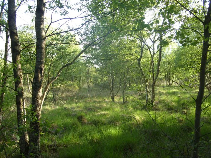
Sunlight filters through trees in a marshy woodland setting with green grass on the forest floor.
A view of the moorland forest landscape in Südliches Hagener Königsmoor.

Südliches Hagener Königsmoor history and protected-area timeline

The historical context of Südliches Hagener Königsmoor is closely tied to the long-term drainage and exploitation of the larger Hagener Königsmoor landscape in the Cuxhaven district of Lower Saxony. Like many lowland peatlands in northwestern Germany, the original moor was progressively drained over centuries, with peat cutting and the creation of an extensive network of drainage ditches reshaping the hydrology of the area.

As most of the surrounding moor was converted to agricultural land, only fragments of the natural bog environment remained. The recognition of one such ecologically valuable remnant led to the formal designation of the area as a nature reserve (Naturschutzgebiet) on 1 March 1981, under the official code NSG LÜ 075. This designation marked an important step in the regional effort to preserve what remained of the district's peatland heritage.

Since its establishment, the reserve has been managed with a focus on protecting its surviving bog flora and hydrological features. The presence of peat cuttings, drainage channels, and partially rewetted neighbouring moorland reflects ongoing efforts to balance the conservation of bog habitats with the realities of a historically drained landscape. Although there is no record of large-scale restoration projects specific to this reserve, it forms part of a wider pattern of peatland protection and partial rewetting in the Landkreis Cuxhaven.

Südliches Hagener Königsmoor landscape and geographic character

Südliches Hagener Königsmoor occupies a low-lying section of the North German Plain, southwest of Hagen im Bremischen, with elevations ranging only from about 5 to 10 metres above sea level. The flat terrain reflects the broader geomorphology of the region, where former glacial and post-glacial processes created extensive lowland moor landscapes that have since been heavily modified by human activity.

The physical character of the reserve is defined by a mosaic of micro-topographic features shaped by centuries of peat exploitation. Shallow peat cuttings, ranging from small excavated hollows to larger water-filled pits in the north and southwest, interrupt the otherwise flat surface. A network of drainage ditches, some of which remain functional, continues to channel water out of the reserve, ultimately feeding into the nearby Drepte stream.

At the edges of the reserve, the landscape transitions into surrounding agricultural land, while to the northeast the reserve borders additional moor areas that have been partially rewetted. This juxtaposition of intensively used farmland, partially restored peatland, and the protected bog remnant highlights the narrow ecological buffer that Südliches Hagener Königsmoor represents within the regional landscape.

Südliches Hagener Königsmoor ecosystems, habitats, and plant life

The nature of Südliches Hagener Königsmoor is shaped by the interplay between its remaining bog habitats and the long history of drainage in the surrounding landscape. Although most of the larger Hagener Königsmoor has been drained and converted, the reserve contains a distinctive mix of vegetation types that together sustain its ecological value.

In the predominantly drained outer areas of the reserve, bog woodland (Bruchwald/Moorwald) has established, with trees adapted to the waterlogged, nutrient-poor conditions of the peat substrate. This wooded fringe forms a transitional zone between the bog habitats and the surrounding agricultural landscape.

The central area of the reserve represents the most ecologically intact section, where peat cuttings and drainage ditches have preserved fragments of raised bog (Hochmoor) vegetation. Here, characteristic bog plants such as cottongrass (Scheidenwollgras), common heather (Besenheide), and cross-leaved heath (Glockenheide) form the core flora, alongside peat moss communities. The edges of the reserve feature additional habitat types, including Molinia grass swards (Pfeifengrasrasen) and peat moss-dominated successional stages in the peat cuttings, contributing further to the habitat diversity of the small protected area.

Südliches Hagener Königsmoor wildlife and species highlights

Given its small size and predominantly bog-forest and raised bog vegetation, Südliches Hagener Königsmoor supports wildlife typical of wetland and peatland habitats in northwestern Germany. The mosaic of bog woodland, relict raised bog, and open water-filled peat cuttings provides habitats for bog-adapted invertebrates, amphibians, and bird species associated with moist woodland and open water.

The water-filled peat cuttings in the north and southwest of the reserve are likely to attract amphibians and aquatic invertebrates, while the bog woodland fringe offers nesting and shelter for typical lowland forest bird species. Although the source material does not list specific species, the reserve's character aligns with regional peatland sites that support dragonflies, damselflies, and bog-specialist insects.

Its broader wildlife value arises less from individual rare species and more from its function as a small refuge within an agricultural matrix. By maintaining a continuous area of bog vegetation and open water amid drained farmland, the reserve contributes to local habitat connectivity and offers refuge for species that have declined across the wider Cuxhaven lowlands.

Südliches Hagener Königsmoor conservation status and protection priorities

Südliches Hagener Königsmoor is significant from a conservation perspective as one of the surviving fragments of the historically much larger Hagener Königsmoor, most of which has been lost to drainage and agricultural conversion. Its designation as a Naturschutzgebiet on 1 March 1981 under the code NSG LÜ 075 reflects formal recognition of its importance for preserving relict raised bog habitats in an otherwise heavily modified landscape.

The reserve falls under IUCN Category IV, designating it as a Habitat/Species Management Area. This classification emphasizes active management to maintain and, where possible, restore the specific habitat features that underpin its ecological value, rather than leaving the area to develop without intervention. The retention of traditional peat cuttings, drainage ditches, and bog woodland within the reserve preserves a record of the landscape's cultural and ecological history.

The partial rewetting of neighbouring moorland to the northeast of the reserve indicates a broader regional approach to peatland conservation, in which small protected areas such as Südliches Hagener Königsmoor serve as core refuges within a wider restoration network. Although modest in scale, the reserve contributes meaningfully to Lower Saxony's wider effort to safeguard peatland biodiversity and relict bog ecosystems in the North German Plain.

Südliches Hagener Königsmoor cultural meaning and human context

The cultural context of Südliches Hagener Königsmoor is rooted in the long history of peat cutting and land reclamation that shaped the lowland landscapes of northwestern Germany. The peat cuttings and drainage ditches preserved within the reserve are remnants of centuries of human interaction with the moor, when local communities extracted peat for fuel and progressively drained the land to expand agricultural use.

In this sense, the reserve is not purely a natural landscape but a palimpsest of human modification, preserving evidence of how generations of rural inhabitants transformed the North German moors. The very features that now support biodiversity, including open peat pits and wet ditches, are partly the result of past economic activity.

Today's management, including the partial rewetting of neighbouring areas, reflects a broader shift in regional land use philosophy, where former peat extraction landscapes are increasingly valued for their ecological and climate-relevant functions. While the reserve itself is not associated with any specific indigenous or ethnic cultural traditions, it embodies the cultural-economic history of the Bremervörde and Cuxhaven rural region, where peatland and farming have long been intertwined.

Top sights and standout views in Südliches Hagener Königsmoor

Südliches Hagener Königsmoor's standout feature is its well-preserved raised bog core, an increasingly rare reminder of the original Hagener Königsmoor landscape amid centuries of drainage. The combination of bog woodland on the outer edges, intact peat cutting hollows, and traditional drainage ditches gives the reserve a layered habitat structure that reflects both natural bog processes and historical human land use.

The presence of larger water-filled peat cuttings in the north and southwest adds a distinctive open-water dimension to what would otherwise be a closed bog woodland habitat. Bordered largely by agricultural land and partially restored peatland, the reserve serves as a small but ecologically meaningful anchor within a wider patchwork of lowland moor conservation efforts in the Cuxhaven district.

Best time to visit Südliches Hagener Königsmoor

Südliches Hagener Königsmoor can be appreciated most meaningfully during the warmer months of late spring through early autumn, when the surrounding lowland moor landscape is most biologically active and accessible. Late spring and early summer bring out the flowering display of bog plants such as cottongrass and heather, which are central to the reserve's character and give the bog woodland and open cuttings their most vivid appearance.

Summer offers the best conditions for observing wetland wildlife around the water-filled peat cuttings, including dragonflies, damselflies, and amphibians. Autumn adds a different dimension, with ripening heather, soft autumnal light over the low-lying terrain, and increased activity of wetland-associated bird species, though visitors should be prepared for cool, damp weather typical of the North German Plain. Winter visits are not generally recommended, as heavy rain, low cloud, and waterlogged ground make the flat, low-elevation bog landscape difficult to access and observe.


Monthly climate preview

Long-term temperature and precipitation patterns recorded across representative coordinates

Südliches Hagener Königsmoor Climate Normals and Annual Weather Rhythm

Recorded multi-year measurements outline the standard temperature ranges and precipitation rates shaping the terrain at Südliches Hagener Königsmoor throughout the year. Reviewing the complete monthly profile provides deeper insight into long-term climate normals and seasonal meteorological variations.
Annual mean9 °C
1 °C18 °C
Jan
Feb
Mar
Apr
May12°
Jun16°
Jul18°
Aug18°
Sep14°
Oct10°
Nov
Dec
Warmest month
July

17.9 °C

Coolest month
January

1.2 °C

Wettest month
July

2.6 mm/day

Driest month
April

1.4 mm/day

Park location guide

Geography guide, regional context, and park location map for Südliches Hagener Königsmoor

Südliches Hagener Königsmoor park geography, regions, and map view in Germany

Understand where Südliches Hagener Königsmoor sits in Germany through a broader geographic reading of the surrounding landscape, nearby location context, and its mapped position within the national park landscape.

How Südliches Hagener Königsmoor fits into Germany

Germany is a federal republic in Western and Central Europe with a population of over 83 million across sixteen constituent states. It is Europe's largest economy by nominal GDP and a major global exporter and importer. The capital is Berlin, and the country borders Denmark, Poland, Czech Republic, Austria, Switzerland, France, Luxembourg, Belgium, and the Netherlands.

Wider geography shaping Südliches Hagener Königsmoor in Germany

Germany is located in Western and Central Europe, spanning 357,022 km². It borders Denmark to the north, Poland and the Czech Republic to the east, Austria and Switzerland to the south, and France, Luxembourg, Belgium, and the Netherlands to the west. The country has coastlines on the Baltic Sea and North Sea to the north, with the Alps located in the southern region.

Map view of Südliches Hagener Königsmoor

Use this park location map to pinpoint Südliches Hagener Königsmoor in Germany, understand its exact geographic position, and read its mapped placement within the surrounding landscape more clearly.

Pigeon | © OpenStreetMap contributors

Location context for Südliches Hagener Königsmoor

Lower Saxony

Photographic reference for raised bog habitats, peat cuttings, and lowland terrain

Visual Exploration of Südliches Hagener Königsmoor Landscapes and Scenery

Visual documentation captures the rare raised bog vegetation, bog woodland fringes, and water filled peat cuttings defining Südliches Hagener Königsmoor. Photographic records reveal the protected terrain, micro topographic features, and lowland moor characteristics preserved within the agricultural surroundings.

Sunlight filters through trees in a marshy woodland setting with green grass on the forest floor.

Park atlas

Discover connected lowland moor landscapes and neighboring peatland reserves in Lower Saxony

Explore Parks Near Südliches Hagener Königsmoor and Regional Protected Areas

Compare Südliches Hagener Königsmoor with other protected lowland moor habitats across the Cuxhaven district. Examining adjacent reserves reveals the broader conservation patterns shaping Northwest Germany's threatened peatland heritage.
Nature reserveLandkreis Cuxhaven
About 9.1 km away#1 closest

Northwest

Teichfledermausgewässer Nature Reserve: Mapped Geography of the Lower Weser Lowland Waters

Protected riverine habitats and lowland water mosaic in Germany

Teichfledermausgewässer functions as a vital nature reserve within the Landkreis Cuxhaven region. This protected landscape encompasses a rich mosaic of oxbow stretches, lowland rivers, and former clay extraction pits that support rare wildlife. Through its integrated water bodies, the reserve forms a continuous conservation corridor that preserves the ecological integrity of the Lower Weser estuary and its unique floodplain ecosystems.

Area
6.33 km²
Established
2018
Protected landscapeNiedersachsen
About 12 km away#2 closest

West

Dornebbe, Braker Sieltief und Colmarer Tief: Mapped Protected Landscape in Niedersachsen

Geographic atlas of tidal lowland waterways and coastal habitats

Dornebbe, Braker Sieltief und Colmarer Tief comprises a chain of slow-flowing streams and bank habitats essential to the coastal marshland geography of Niedersachsen. The area provides a structured look at multi-layered habitat protection, featuring dense reedbeds and aquatic corridors vital for regional biodiversity in the German tidal zone.

Area
0.33 km²
Established
2018
Nature reserveLower Saxony
About 13 km away#3 closest

Northwest

Strohauser Vorländer und Plate Nature Reserve: Geography and Protected Area Atlas

Tidal wetlands and freshwater habitats in Lower Saxony

The Strohauser Vorländer und Plate nature reserve protects a expansive tidal floodplain characterized by its river island geography, slow-moving side arms, and seasonal inundation patterns. As a focal point for meadow-bird monitoring, this site offers a clear view into the ecological dynamics of the Lower Weser river landscape, showcasing a rare combination of summer-dike-protected meadows and open freshwater tidal flats.

Area
11.52 km²
Established
2007
IUCN
IV
Nature reserveBremen
About 15 km away#4 closest

South

Hammersbecker Wiesen: Protected Nature Reserve and Meadow Landscape in Bremen

Ecological mosaic of wet meadows and stream valley terrain

Hammersbecker Wiesen encompasses 25.8 hectares of ecologically significant wet grassland and hedgerow habitats in Bremen. This nature reserve provides an essential refuge for diverse plant species and local amphibians within an urban-adjacent setting, illustrating the preserved character of traditional northern German meadow systems.

Area
0.258 km²
Established
1986
A horizontal watercolor painting depicting a soft-focus landscape with a pond in the foreground, pink and green heath vegetation, and distant tree lines under a pale sky.
Nature reserveBremen
About 15 km away#5 closest

South

Eispohl, Sandwehen und Heideweiher: Protected Landscape and Geest Geography

Nature reserve featuring historic dunes and heath pond networks

This nature reserve in Bremen protects a remnant of the Rekumer Geest, featuring a complex of inland dunes, wet heath, and small heath ponds. Through its combination of extensively grazed grasslands and mixed forests, the area serves as a vital habitat corridor, maintaining the traditional Geest landscape patterns that once dominated the region between Bremen and the lower Weser.

Area
0.036 km²
Established
1988
Relief
Lowland
Climate
Temperate
Nature reserveBremen
About 17 km away#6 closest

South

Ruschdahlmoor Nature Reserve: Deep Peatlands and Protected Wetland Geography in Bremen

Geological subsidence sinkhole and urban protected landscape

Ruschdahlmoor stands as a unique nature reserve in Bremen, Germany, distinguished by a peat-forming wetland developed inside a sinkhole over the Lesum salt dome. This protected area supports tall herb meadows, reed-fringed ponds, and rare peat-depth records, offering a dense, ecologically rich landscape context that remains a vital part of the city's natural geography.

Area
0.048 km²
Established
1991
IUCN
IV
Relief
Lowland
A soft, light-toned watercolor painting of a wetland landscape featuring green fields, a small path, a line of trees, and a distant low hill.
Nature reserveBremen
About 18 km away#7 closest

North

Luneplate Nature Reserve: A Detailed Geographic Atlas of Bremen's Coastal Wetland Landscapes

Protected estuarine habitats and tidal geography in the Weser river basin

Luneplate Nature Reserve offers a rich study of coastal wetland geography. Spanning the interface between the Weser river and the North Sea, the reserve features extensive mudflats, saltmarshes, and reedbeds. This protected landscape serves as an essential migratory hub, providing habitat for diverse waterbird populations within the maritime environment of Bremerhaven.

Area
14.38 km²
Established
2015
IUCN
IV
Nature reserveBremen
About 19 km away#8 closest

Southeast

Untere Wümme Nature Reserve: Riverine Biodiversity and Protected Tidal Landscapes in Bremen

Protected floodplain geography and tidal river habitats.

This nature reserve protects the meandering lower course of the Wümme river, showcasing one of northern Germany's few freshwater tidal systems. Spanning reedbeds, willow forests, and open mudflats, the reserve forms a vital corridor for migratory fish and waterfowl, reflecting a complex mosaic of protected riverine ecosystems and historic meadow landscapes.

Area
1.485 km²
Established
1991
Relief
Lowland
Climate
Temperate

Common questions about visiting, size, designation, and location context for Südliches Hagener Königsmoor

Südliches Hagener Königsmoor FAQs for park facts, access, geography, and protected area context

Find quick answers about Südliches Hagener Königsmoor, including protected-area facts, park geography, trail and visitor context, and how the park fits into its surrounding country and regional landscape.
MoriAtlas Explorer

Continue Your Protected Areas Search Across the Global Atlas

Deepen your exploration by continuing the structured search for national parks and protected areas worldwide. Utilize the comprehensive filtering capabilities to compare different conservation landscapes and refine your understanding of global park geography. Discover more about the distribution and characteristics of protected natural areas.

Global natural geography