Mori Atlas logo
National parkSumaco Napo-Galeras National Park

Discover the mapped geography and unique ecosystems of this Andean-Amazon transition zone.

Sumaco Napo-Galeras National Park: Ecuador's Volcanic Protected Landscape & Biodiversity Hotspot

(Parque Nacional Sumaco Napo-Galeras)

Sumaco Napo-Galeras National Park in Ecuador represents a critical protected area at the convergence of the Andes and the Amazon basin. This national park is defined by the imposing Sumaco volcano, creating dramatic elevation gradients from cloud forest to tropical rainforest. Its diverse terrains and volcanic origins foster exceptional biodiversity, including endemic species and a rich array of birdlife, making it a key site for atlas-driven landscape exploration.

volcanic landscapesAmazon rainforestcloud forestsendemic speciesbirdwatchingtropical biodiversity

Sumaco Napo-Galeras National Park

National park

Park overview

Structured park overview, official facts, and landscape profile for Sumaco Napo-Galeras National Park

Sumaco Napo-Galeras National Park park facts, protected area profile, and essential visitor context

Review the core facts for Sumaco Napo-Galeras National Park, including designation, size, terrain, visitor scale, habitats, and operating context in one park-focused overview.

About Sumaco Napo-Galeras National Park

Sumaco Napo-Galeras National Park represents one of Ecuador's most important protected areas for biodiversity conservation in the Amazon region. The park's central feature, Sumaco volcano, is an active stratovolcano that has shaped both the geological and ecological character of the surrounding landscape over millions of years. The volcanic activity has produced fertile soils and created diverse microhabitats that support an extraordinary range of plant and animal species.

The park occupies a critical position in Ecuador's protected area network, connecting the Amazon lowlands with the Andean highlands. This transitional position means the park contains elements of both ecosystems, creating unique ecological communities that cannot be found elsewhere. The steep terrain and remote location have historically limited human development in the area, allowing natural processes to continue largely unimpeded.

From a conservation perspective, the park addresses several important ecological priorities. It protects watersheds that feed into the Napo River system, a major tributary of the Amazon. The forest cover helps regulate water cycles and prevents soil erosion on the volcanic slopes. The diverse elevations provide climate change resilience, as species can potentially migrate upslope as temperatures warm. The protected area also supports connectivity with other parks in the region, creating a larger conservation landscape that allows wildlife to move across larger territories.

Quick facts and research context for Sumaco Napo-Galeras National Park

Sumaco Napo-Galeras National Park covers approximately 206,749 hectares in northeastern Ecuador. The park was established on March 2, 1994, and is classified as an IUCN Category II protected area. The park spans three provinces: Napo, Orellana, and Sucumbíos, with its highest point being Sumaco volcano at 3,732 meters above sea level. The elevation range from 600 to 3,732 meters creates diverse ecological zones within the park's boundaries.

Protection and recognition

Atlas data on the official terrestrial management scope and conservation status

Sumaco Napo-Galeras National Park Protection Status and Designation

National park database records present the documented terrestrial protection status and established management framework for Sumaco Napo-Galeras National Park. Accessing official conservation boundaries assists researchers in mapping out the environmental designation context within the wider global registry of protected areas.

Protection details

Protection scope
Terrestrial
Park context

Deeper park guide and search-rich context for Sumaco Napo-Galeras National Park

Sumaco Napo-Galeras National Park history, landscape, wildlife, and travel context

Explore Sumaco Napo-Galeras National Park through its history, landscape character, ecosystems, wildlife, conservation priorities, cultural context, and seasonal travel timing in a structured park guide built for atlas discovery and search intent.

Why Sumaco Napo-Galeras National Park stands out

Sumaco Napo-Galeras is best known for its dramatic volcanic mountain landscape, which serves as a biodiversity hotspot in the Amazon region. The park protects the distinctive Sumaco volcano, a conical stratovolcano that is one of the most prominent peaks in this part of Ecuador. The area is renowned for its exceptional bird diversity, with approximately 280 documented species and many more believed to exist in the unexplored regions. The park is particularly famous for several endemic amphibian species that are found only on the slopes and summit of Sumaco, including the toad Osornophryne sumacoensis and the frog Pristimantis ernesti. Additionally, the park protects important populations of large mammals including the jaguar, spectacled bear, mountain tapir, and puma.

Sumaco Napo-Galeras National Park history and protected-area timeline

Sumaco Napo-Galeras National Park was established on March 2, 1994, making it one of the more recent additions to Ecuador's national park system. The creation of the park responded to growing recognition of the region's exceptional biodiversity and the need to protect the unique ecosystems found on Sumaco volcano and in the surrounding Amazon foothills. Prior to national park designation, the area had limited formal protection though its remote location and difficult terrain naturally limited significant development pressures.

The establishment of the park reflected Ecuador's broader commitment to biodiversity conservation during the 1990s, a period when the country was expanding its protected area network. The park was designated under Ecuador's legal framework for protected areas and classified as an IUCN Category II protected area, reflecting its primary purpose of protecting natural ecosystems while allowing for limited sustainable use. The boundaries were drawn to encompass the entire Sumaco volcano and its surrounding slopes, ensuring the volcanic ecosystem and its associated biodiversity would be preserved as a unified conservation unit.

Sumaco Napo-Galeras National Park landscape and geographic character

The landscape of Sumaco Napo-Galeras is dominated by the imposing form of Sumaco volcano, a symmetrical stratovolcano that rises dramatically from the surrounding terrain. The mountain's steep slopes are carved by numerous ravines and waterways that descend from the upper elevations down to the Amazon basin. The elevation range of nearly 3,200 meters creates dramatic changes in vegetation and scenery across the park's extent.

At higher elevations, the terrain features cloud forest with steep, often nearly vertical sections. The upper slopes are frequently shrouded in mist and clouds, creating an atmospheric landscape quite different from the lowland Amazon. As elevation decreases, the forest becomes progressively more tropical in character, with larger trees, more dense undergrowth, and the emergence of typical Amazonian species. The transition between these zones is gradual rather than abrupt, creating a complex mosaic of habitats.

The lower elevations of the park feature rolling terrain typical of the Amazon foothills, with valleys carved by rivers flowing toward the Napo system. These lower areas are characterized by humid tropical forest, wetlands, and areas of secondary growth where natural disturbance has opened the canopy. The contrast between the volcanic peak and the surrounding foothills creates a visually striking landscape that defines the park's character.

Sumaco Napo-Galeras National Park ecosystems, habitats, and plant life

The ecological character of Sumaco Napo-Galeras reflects its position at the intersection of multiple biogeographic zones. The park spans the transition from Andean cloud forest at higher elevations to Amazonian tropical rainforest in the lower zones, creating a complex mosaic of habitats. This environmental diversity supports an extraordinary range of plant and animal species, many of which are found only in this specific region.

The vegetation patterns follow the elevation gradient, with distinct forest types occurring at different altitudes. The cloud forest zone features epiphytes, mosses, and ferns that thrive in the perpetually moist conditions. The mid-elevation forests are characterized by dense canopy trees and diverse understory plants. The lower zones contain classic Amazonian forest with large emergent trees, extensive buttress roots, and diverse lianas. These different forest types each support distinctive ecological communities.

The park's biodiversity remains incompletely documented, with scientists continuing to discover new species in the relatively unexplored areas. The combination of habitat diversity, geographic isolation created by the volcanic peak, and the transitional location has produced what appears to be a significant center of endemism. Several species are known only from the Sumaco area, indicating the region's unique evolutionary character.

Sumaco Napo-Galeras National Park wildlife and species highlights

The wildlife of Sumaco Napo-Galeras is exceptionally diverse, with particular significance for birds, mammals, and amphibians. Approximately 280 bird species have been documented within the park, though the true total is believed to be substantially higher given the limited scientific exploration. Notable bird species include the western tyrannulet, spot-winged parrotlet, military macaw, and the colorful puffbird known as the glossy-backed puffbird. Many of these species are associated with the forest interior and are sensitive to disturbance.

The mammal fauna includes important large predators and flagship species. Jaguars roam the forest, while pumas occupy similar ecological niches at slightly different elevations. The spectacled bear, South America's only bear species, is found in the higher forest zones. Mountain tapirs, giant anteaters, and other large mammals complete the mammalian community. The bat survey at 2,500 meters documented at least eight species, indicating the importance of these often-overlooked mammals in the park's ecosystem.

The amphibian fauna is of particular conservation significance. Several species are known only from the Sumaco area, including the toad Osornophryne sumacoensis found only on the eastern slopes and the frog Pristimantis ernesti known only from the summit region. These narrow endemics make the park globally important for amphibian conservation. The combination of humid conditions, elevation gradients, and relatively limited human disturbance has allowed these unique species to persist.

Sumaco Napo-Galeras National Park conservation status and protection priorities

Sumaco Napo-Galeras plays a critical role in Ecuador's conservation strategy for Amazon biodiversity. The park protects a volcanic mountain ecosystem that is unique within the country, preserving both the geological heritage of Sumaco and the biological communities it supports. The protected area connects with the broader network of Amazonian parks, forming part of a larger landscape that allows wildlife populations to maintain genetic connectivity.

The park addresses several conservation priorities simultaneously. It protects watersheds that feed major river systems, ensuring clean water for downstream communities. It preserves forest cover that stores significant amounts of carbon, contributing to climate mitigation. It protects habitats for species of conservation concern, including jaguars, spectacled bears, and mountain tapirs. The endemic amphibians represent a particularly important conservation focus, as these species cannot be found anywhere else on Earth.

The protection of Sumaco also provides ecological insurance against climate change. The elevational gradient allows species to potentially migrate upward as temperatures warm, maintaining suitable habitats within the protected boundaries. The diverse topography creates multiple microclimates, increasing the likelihood that some suitable habitats will persist under changing conditions.

Sumaco Napo-Galeras National Park cultural meaning and human context

Sumaco Napo-Galeras is situated in a region that has been inhabited by indigenous peoples for millennia. The area falls within the territory of various Amazonian indigenous groups who have traditional relationships with the forest and its resources. While the park itself is managed as a strictly protected area, the surrounding landscapes contain communities whose cultural practices and traditional knowledge are connected to the broader Amazonian environment.

The park's name reflects the local geography, with Sumaco referring to the volcano and Napo-Galeras referencing the broader region. This naming convention connects the protected area to local place-based identities and helps maintain the link between the landscape and the communities who have long inhabited this part of the Amazon. The cultural context of the region adds depth to the park's significance beyond its biological values.

Top sights and standout views in Sumaco Napo-Galeras National Park

Sumaco Napo-Galeras stands out as a conservation jewel in the Ecuadorian Amazon, protecting the iconic Sumaco volcano and the extraordinary biodiversity that surrounds it. The park's elevation gradient from 600 to 3,732 meters creates a complete transition from Amazonian lowland forest to cloud forest, supporting remarkable species diversity. The presence of endemic amphibians known nowhere else on Earth, including the Sumaco toad and summit frog, makes this park globally significant for biodiversity. The documented 280 bird species and populations of jaguars, spectacled bears, and mountain tapirs reinforce the park's importance as a wildlife refuge. The relatively unexplored nature of the park means that new discoveries likely await scientists who venture into its remote forests.

Best time to visit Sumaco Napo-Galeras National Park

The climate in Sumaco Napo-Galeras follows typical Amazon patterns, with a wet season from roughly December through May and a drier period from June to November. The wet season brings heavier rainfall, particularly to the lower elevations, while the higher elevations may experience persistent mist and cloud. The drier months typically offer more comfortable conditions for exploration, though rain can occur at any time given the humid environment. Visitors should expect warm temperatures in the lowlands and cooler conditions at higher elevations. The best time for wildlife viewing often coincides with the drier months when animals may concentrate around water sources, though the wet season offers its own rewards in terms of forest productivity and water feature activity.
Monthly climate preview

Long-term temperature averages and monthly precipitation records at 1168 meters elevation

Sumaco Napo-Galeras National Park Climate and Monthly Weather Normals

Long term climate measurements from 1991 through 2020 show that the park territory around 1168 meters elevation experiences steady monthly mean temperatures between 18.98 and 20.70 degrees Celsius with rainfall throughout the year. Examining the complete weather by month dataset provides critical context on seasonal cycles and daily precipitation averages across different periods.
Annual mean20 °C
19 °C21 °C
Jan20°
Feb21°
Mar20°
Apr20°
May20°
Jun19°
Jul19°
Aug20°
Sep21°
Oct21°
Nov20°
Dec20°
Warmest month
September

20.7 °C

Coolest month
July

19 °C

Wettest month
April

6.1 mm/day

Driest month
August

3.1 mm/day

Park location guide

Geography guide, regional context, and park location map for Sumaco Napo-Galeras National Park

Sumaco Napo-Galeras National Park park geography, regions, and map view in Ecuador

Understand where Sumaco Napo-Galeras National Park sits in Ecuador through a broader geographic reading of the surrounding landscape, nearby location context, and its mapped position within the national park landscape.

How Sumaco Napo-Galeras National Park fits into Ecuador

Ecuador is a presidential republic located in northwestern South America, with Quito as its capital and Guayaquil as its largest city. The country spans 283,561 km² and encompasses the Galápagos Islands, a volcanic archipelago famous for unique wildlife that helped shape Darwin's theory of evolution. Ecuador is a plurinational state with Spanish as the official language, though Kichwa and Shuar are recognized for indigenous peoples.

Wider geography shaping Sumaco Napo-Galeras National Park in Ecuador

Ecuador is located in northwestern South America along the Pacific coast. It shares borders with Colombia to the north and Peru to the east and south. The country includes the Galápagos Islands, a volcanic archipelago in the Pacific Ocean approximately 1,000 km west of the mainland. The territory encompasses diverse terrain including the Amazon rainforest in the east, the Andean highlands in the center, and coastal plains along the Pacific.

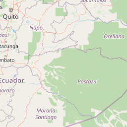
Map view of Sumaco Napo-Galeras National Park

Use this park location map to pinpoint Sumaco Napo-Galeras National Park in Ecuador, understand its exact geographic position, and read its mapped placement within the surrounding landscape more clearly.

Pigeon | © OpenStreetMap contributors

Location context for Sumaco Napo-Galeras National Park

Napo ProvinceOrellana ProvinceSucumbíos Province
Natural feature types

View the Complete Natural Feature Atlas for Sumaco Napo-Galeras National Park

Navigate the full collection of named landforms and natural landmarks identified within Sumaco Napo-Galeras National Park. MoriAtlas provides a clear geographic context for the volcanic peaks, forests, and hydrological systems that shape this critical protected corridor in the Ecuadorian Amazon.
Recorded earthquake history

Explore Historical Earthquake Records for Sumaco Napo-Galeras National Park

View the documented history of seismic events associated with the geography of Sumaco Napo-Galeras National Park. This MoriAtlas catalogue provides structured access to event parameters for those interested in the regional seismic record of this protected Andean-Amazon zone.

Sumaco Napo-Galeras Earthquake History

Catalogued events

117 events

Strongest magnitude

Magnitude 7.2

Most recent event

Mar 15, 2026

This history includes earthquakes recorded inside the park or within 50 km of its borders

Park atlas

Compare additional protected areas and map the broader park geography of Ecuador's Andean-Amazon transition zone beyond Sumaco Napo-Galeras National Park.

Find Related Protected Areas Near Sumaco Napo-Galeras National Park in Ecuador

After exploring Sumaco Napo-Galeras National Park, browse other protected areas in the Ecuadorian Amazon and Andean foothills. Expand your understanding of regional conservation landscapes, comparing similar ecosystems and volcanic terrain across Ecuador's park geography.
National parkNapo
Park boundaries overlap#1 closest

West

Parque nacional Antisana: Volcanic Terrain and Andean Protected Area Geography

High-altitude ecosystems spanning Napo and the Andean corridor

Spanning the rugged Cordillera Real, Parque nacional Antisana protects a vast sweep of volcanic terrain dominated by its central stratovolcano. From glacial fields to the water-retention capacity of its páramo wetlands, the area represents a crucial node in Ecuador's conservation network, providing a sanctuary for Andean condors and diverse montane species.

Area
1,205.81 km²
Established
1993
IUCN
Ia
Relief
Mountain
Nature reserveSucumbíos
30 km away#2 closest

North

Reserva Ecológica Cofán-Bermejo: Mapping Amazonian and Andean Biodiversity Landscapes

Indigenous-led conservation in the Sucumbíos river headwaters.

Reserva Ecológica Cofán-Bermejo encompasses a remarkable altitudinal range from 400 to 2,200 meters, protecting intact river basins and transitional ecosystems. This nature reserve offers deep insight into the convergence of Amazonian and Andean flora, functioning as a vital refuge for threatened megafauna and rare bird populations within an indigenous-managed territory.

Area
549.47 km²
Established
2002
IUCN
Ia
Relief
Mountain
National parkEcuador
About 36 km away#3 closest

Northwest

Parque nacional Cayambe-Coca: Regional Geography and Protected Landscape Analysis

Equatorial volcanic peaks and Amazonian slope geography

Examine the physical geography of Parque nacional Cayambe-Coca, a protected area in Ecuador known for its extreme elevation shifts. The mapped terrain transitions from the glaciated summit of Volcán Cayambe through extensive páramo wetlands and montane cloud forests into the Amazonian foothills, providing a comprehensive case study of Andean environmental gradients.

Area
4,031.03 km²
Established
1970
IUCN
II
Relief
Mountain
Biosphere reserveNapo
About 40 km away#4 closest

Southwest

Reserva Biológica Colonso-Chalupas: Protected Landscapes of the Upper Napo Basin

A critical vertical corridor of the Ecuadorian Andes and Amazon.

Reserva Biológica Colonso-Chalupas represents a unique bioclimatic transition, stretching nearly 4,000 meters in elevation. This biosphere reserve serves as a functional corridor connecting high-altitude páramo and cloud forests to warm, humid Amazonian lowlands, forming a key structural element of the eastern Andean conservation landscape.

Area
931.63 km²
Established
2014
Relief
Mountain
Climate
Alpine
National parkEcuador
42 km away#5 closest

Southwest

Llanganates National Park: Detailed Atlas Entry for Ecuador's Protected Landscape

Explore the mapped geography and regional context of this Ecuadorian national park.

Llanganates National Park is a designated national park offering rich opportunities for geographic and landscape exploration. As a significant protected area in Ecuador, it provides crucial context for understanding the country's natural terrain and the distribution of its conservation landscapes. This entry is designed to facilitate an atlas-style discovery of the park's location, boundaries, and its role within the broader geography of the region.

Area
2,197.07 km²
Established
1996
IUCN
II
Relief
Mountain
National parkCotopaxi Province
62 km away#6 closest

West

Cotopaxi National Park: Ecuador's Mapped Protected Landscape and Regional Geography

Explore the geographic context of this national park.

Cotopaxi National Park represents a key protected landscape within Ecuador, located in Cotopaxi Province. This page facilitates detailed exploration of the park's mapped boundaries and its contribution to the regional geography. Understand the specific characteristics of this national park as part of a broader atlas of protected areas and natural terrains.

Area
333.93 km²
Established
1975
IUCN
II
Relief
Mountain
Wildlife reserveSucumbíos
71 km away#7 closest

East

Reserva Biológica Limoncocha: Geography, Wetland Ecosystems, and Protected Boundaries

A vital Amazonian wildlife reserve in the Sucumbíos province.

Reserva Biológica Limoncocha is a distinctive wetland reserve defined by its intricate system of lagoons, rivers, and seasonal floodplains. Its geography provides a rare look at Amazonian biodiversity, ranging from elevated forest plateaus to permanently inundated palm swamps and vital black caiman habitats.

Area
46.13 km²
Established
1985
IUCN
VI
Relief
Lowland
Wildlife reserveSucumbíos
75 km away#8 closest

East

Reserva de Producción de Fauna Cuyabeno: Geography of an Amazonian Wildlife Reserve

Explore protected boundaries and flooded landscape patterns in Sucumbíos

Reserva de Producción de Fauna Cuyabeno serves as a benchmark for Amazonian conservation, characterized by its extraordinary hydrological dynamics. The landscape comprises a network of blackwater rivers and semi-permanent lagoons that sustain an immense variety of species. As a protected area within Sucumbíos, it showcases the intricate relationship between seasonally submerged forests, terra firme terrain, and the vital river arteries that define this region.

Area
5,901.12 km²
Established
1979
IUCN
VI
Visitors
12K annual

Common questions about visiting, size, designation, and location context for Sumaco Napo-Galeras National Park

Sumaco Napo-Galeras National Park FAQs for park facts, access, geography, and protected area context

Find quick answers about Sumaco Napo-Galeras National Park, including protected-area facts, park geography, trail and visitor context, and how the park fits into its surrounding country and regional landscape.
MoriAtlas Explorer

Continue Your Protected Areas Search Across the Global Atlas

Deepen your exploration by continuing the structured search for national parks and protected areas worldwide. Utilize the comprehensive filtering capabilities to compare different conservation landscapes and refine your understanding of global park geography. Discover more about the distribution and characteristics of protected natural areas.

Global natural geography