
Mori Atlas logo
Nature reservePulai River

A critical Ramsar wetland protecting the largest seagrass bed and mangrove forests in Malaysia.

Pulai River Nature Reserve: Mapping the Coastal Mangrove and Estuarine Landscapes of Johor

Pulai River Nature Reserve represents a vital coastal landscape where forest headwaters from Mount Pulai transition into an expansive tidal estuary along the Tebrau Straits. This protected area stands as a central feature of Johor geography, defined by its extensive mangrove fringes and an internationally significant seagrass meadow extending toward Pulau Merambong. As a designated Ramsar wetland, the region provides essential habitat for coastal biodiversity within the southern Malay Peninsula.

mangrove forestestuaryRamsar wetlandseagrass bedcoastal ecosystemriver
A graphic illustration showing a river winding through a valley towards a waterfall flowing down a rocky mountain side, surrounded by trees.

Pulai River

Nature reserve

Park overview

Structured park overview, official facts, and landscape profile for Pulai River

Pulai River park facts, protected area profile, and essential visitor context

Review the core facts for Pulai River, including designation, size, terrain, visitor scale, habitats, and operating context in one park-focused overview.

About Pulai River

Pulai River flows through part of southern Johor, originating on the slopes of Mount Pulai in the Kulai District and traveling roughly 22 kilometers before emptying into the Tebrau Straits near Tanjung Pelepas. The lower river and its tidal estuary occupy a transitional zone where freshwater from the catchment meets the saline waters of the strait, creating the conditions necessary for one of Malaysia's most distinctive coastal wetland complexes.

The defining feature of Pulai River is its mangrove forest reserve, which lines the tidal reaches of the waterway and extends across the broader estuarine landscape. These mangroves form a dense, productive fringe that stabilizes sediments, filters nutrients, and provides shelter for a wide range of marine life. Conjoined with this is a vast seagrass bed at the river's mouth, covering an area that stretches outward to the nearby Pulau Merambong. Seagrass meadows such as this one support fish spawning, juvenile habitat, feeding dugongs and sea turtles, and an immense diversity of invertebrates.

Pulai River's environmental significance has earned it international recognition. Designated in 2003, the site is part of the global Ramsar network of wetlands of international importance, joining a select group of Malaysian sites that meet strict criteria for ecological value. Beyond the formal designation, the site functions as a living laboratory for mangrove and seagrass research. Universities including University of Technology Malaysia and the National University of Malaysia have contributed to studies of the ecosystem, building the knowledge base needed for sustainable management under an Integrated Management Plan focused on the long-term health of Johor's mangroves.

Quick facts and research context for Pulai River

Pulai River is a Johor-based river in southern Peninsular Malaysia, with its headwaters in Mount Pulai and its mouth at the Tebrau Straits near Tanjung Pelepas. It is designated as a Ramsar site under the official name Sungai Pulai, with reference number 1288 and a designation date of 31 January 2003. The river's estuary protects a mangrove forest reserve and the largest seagrass bed in Malaysia, extending to Pulau Merambong. Conservation planning is coordinated through the Johor National Parks Corporation and supported by research partnerships with Malaysian universities.

Protection and recognition

Documented management scope and international recognition records

Pulai River Protection Status and Formal Conservation Designations

Pulai River features a mixed protection scope governed by established conservation frameworks and administrative boundaries. Official records document the designated status and international recognition details associated with the protected area.

Protection details

Protection scope
Mixed
Transboundary protection
No
Park context

Deeper park guide and search-rich context for Pulai River

Pulai River history, landscape, wildlife, and travel context

Explore Pulai River through its history, landscape character, ecosystems, wildlife, conservation priorities, cultural context, and seasonal travel timing in a structured park guide built for atlas discovery and search intent.

Why Pulai River stands out

Pulai River is best known for the extraordinary estuarine ecosystem at its mouth, where a substantial mangrove forest reserve meets the single largest seagrass bed in Malaysia. This combination of mangrove and submerged seagrass habitat makes the site one of the most important coastal wetlands in the country. The estuary's Ramsar designation reflects its status as a wetland of international importance, recognizing both its biodiversity and its role as habitat for migratory bird populations along the Johor coastline.
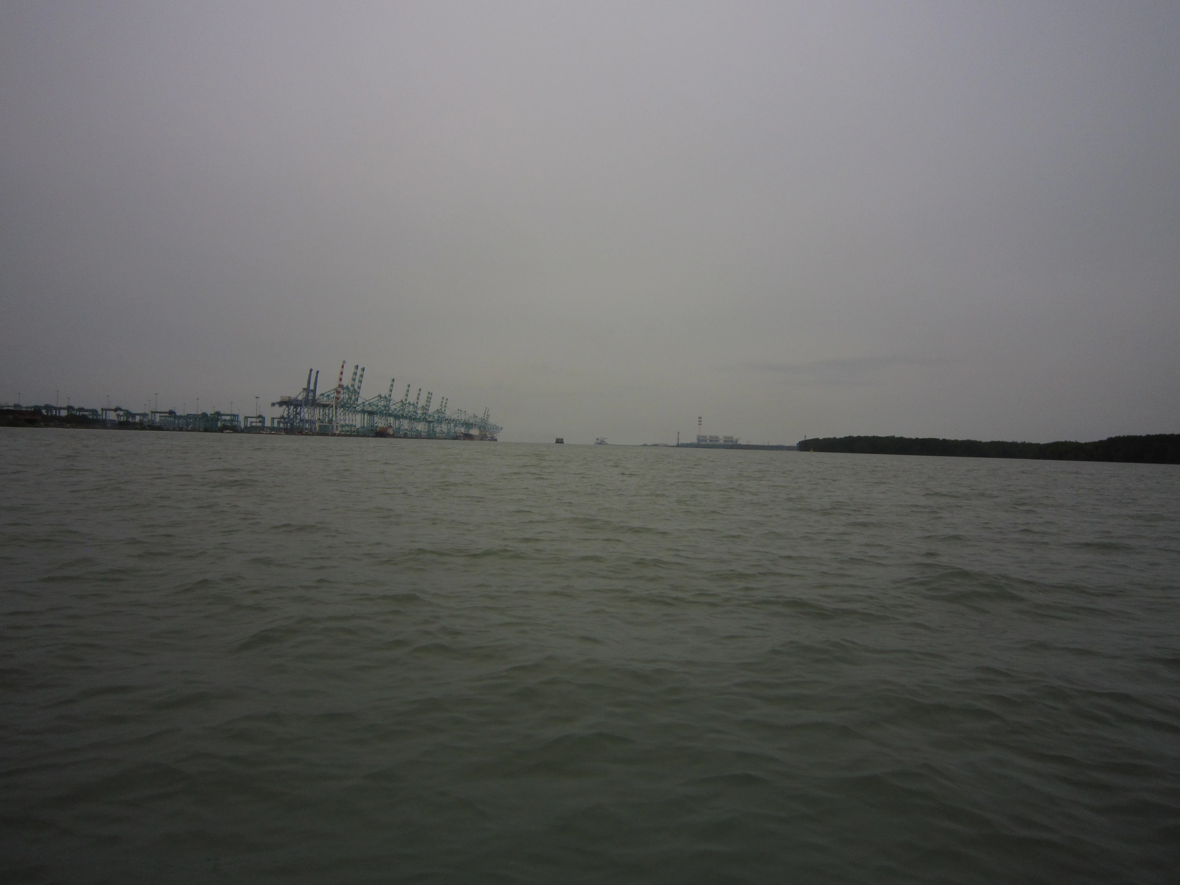
A wide view of the Pulai River mouth under an overcast sky, with dense mangrove forest on the right bank and industrial shipping cranes visible on the left bank.
The mouth of the Pulai River, showcasing the intersection of the natural mangrove estuary and industrial port infrastructure.

Pulai River history and protected-area timeline

Pulai River was designated as a Ramsar wetland on 31 January 2003, formally recognizing the ecological value of its mangrove estuary and adjacent seagrass bed. The designation placed the site within the global Ramsar network under the official name Sungai Pulai, with reference number 1288.

Following the Ramsar listing, the Johor state government, through the Johor National Parks Corporation, worked to develop Sungai Pulai as a recognized bird and wetland area under the Ramsar framework. The site has since become a focus of academic and applied research, with university partners contributing to ecological surveys, seagrass mapping, and management planning aimed at balancing conservation with sustainable use of the mangrove ecosystem.

Pulai River landscape and geographic character

The landscape of Pulai River is shaped by the meeting of forested highlands and a wide tidal estuary. In its upper reaches, the river descends from the slopes of Mount Pulai, traveling through a relatively short catchment of about 22 kilometers before reaching the lowlands.

In its lower course, the river broadens into an expansive estuarine system opening onto the Tebrau Straits. Dense mangrove forests line much of the tidal shoreline, forming a continuous green fringe that softens the transition from land to sea. At the mouth, the submerged environment opens into a flat seagrass meadow that extends offshore toward Pulau Merambong, creating a distinctive interface between mangrove, seagrass, and open strait.

Pulai River ecosystems, habitats, and plant life

The ecological character of Pulai River is dominated by its mangrove forest reserve and tidal estuary. The mangroves form the core of the site's vegetation, creating a structurally complex habitat of rooted trees, pneumatophores, and sheltered tidal channels. This habitat supports nutrient cycling, sediment stabilization, and serves as nursery ground for many commercially and ecologically important fish and crustacean species.

At the seaward edge of the estuary lies the largest seagrass bed in Malaysia, a submerged flowering plant community that extends out toward Pulau Merambong. Seagrass meadows of this scale are vital for coastal productivity, providing feeding grounds for marine life and contributing significantly to the overall health of the Tebrau Straits ecosystem. The combination of mangrove and seagrass habitats creates a layered coastal wetland with rich biodiversity and strong ecological connectivity between fresh, brackish, and marine environments.

Pulai River wildlife and species highlights

The Pulai River estuary supports a diverse community of coastal and wetland-associated wildlife. The mangrove forest and adjacent seagrass bed together provide shelter, feeding, and breeding habitat for fish, crustaceans, mollusks, and a variety of marine invertebrates. The site has been developed as a designated bird area, reflecting its importance for waterbirds and shorebirds that depend on the mangrove-fringed tidal flats.

Beyond the birdlife, the seagrass meadow's productivity underpins a wider marine food web, supporting species that range from small reef and benthic organisms to larger marine fauna that seasonally use the estuary. The combination of freshwater inflow, mangrove structure, and seagrass cover makes the lower river a particularly productive habitat within the Johor coastline.

Pulai River conservation status and protection priorities

Conservation significance is central to Pulai River's identity. Designated as a Ramsar wetland in 2003, the site is officially recognized as a wetland of international importance, referenced under number 1288. The designation underscores the global value of its mangrove forest reserve and the country's largest seagrass bed, both of which play critical roles in sustaining coastal biodiversity and water quality along the Tebrau Straits.

Management of the site has been strengthened through academic partnerships. Research from University of Technology Malaysia and the National University of Malaysia has contributed to ecological understanding of the mangrove and seagrass ecosystems, supporting the Integrated Management Plan for the sustainable use of mangroves in Johor. The Johor National Parks Corporation oversees the site as part of the state's protected-area framework, working to maintain habitat integrity while accommodating ongoing scientific study.

Pulai River cultural meaning and human context

Pulai River occupies a small but notable place in Johor's regional identity, particularly through its connection to the state-managed protected-area framework under the Johor National Parks Corporation. The river also shares its name with nearby settlements and the broader Pulai region, including Kulai District on the inland side and the Mukim Pulai area closer to the coast, reflecting how the waterway has historically helped define local geography and community association in southwestern Johor.

Top sights and standout views in Pulai River

The standout features of Pulai River converge at its estuary, where one of Malaysia's most impressive mangrove forest reserves meets the country's largest seagrass bed. The tidal environment supports rich marine and birdlife, anchored by its 2003 Ramsar designation and ongoing university-led research.

Best time to visit Pulai River

As a tidal mangrove and seagrass estuary, Pulai River is shaped by the rhythms of the coast rather than by dramatic seasonal swings. The mangrove forest and surrounding tidal flats remain ecologically active throughout the year, and conditions are generally influenced more by tidal cycles than by the broader monsoon-driven weather patterns of the region. Visitors focused on birdwatching, ecological study, or quiet appreciation of the estuary landscape will find the area compelling across much of the year, while researchers and conservationists typically work with the site on an ongoing, season-independent basis.

Monthly climate preview

Long term temperature and precipitation patterns across Johor

Pulai River Climate Normals and Annual Weather by Month

Historical climate records for Pulai River reveal steady thermal ranges alongside marked variations in monthly precipitation levels. Detailed weather by month breakdowns provide complete long term averages for ongoing geographical analysis.
Annual mean27 °C
26 °C28 °C
Jan26°
Feb26°
Mar27°
Apr28°
May28°
Jun28°
Jul27°
Aug27°
Sep27°
Oct27°
Nov27°
Dec26°
Warmest month
May

28 °C

Coolest month
January

25.9 °C

Wettest month
December

9.8 mm/day

Driest month
February

3.6 mm/day

Park location guide

Geography guide, regional context, and park location map for Pulai River

Pulai River park geography, regions, and map view in Malaysia

Understand where Pulai River sits in Malaysia through a broader geographic reading of the surrounding landscape, nearby location context, and its mapped position within the national park landscape.

How Pulai River fits into Malaysia

Malaysia is a federal constitutional monarchy located in Southeast Asia. The country consists of 13 states and three federal territories, divided by the South China Sea into Peninsular Malaysia on the Indochinese Peninsula and East Malaysia on the island of Borneo. With a population of over 34 million, it achieved independence from Britain in 1957 and became a modern federation in 1963. The country is recognized for its multicultural population, tropical climate, and significant economic role in the region.

Wider geography shaping Pulai River in Malaysia

Malaysia occupies a strategic position in Southeast Asia, split by the South China Sea into two distinct regions. Peninsular Malaysia lies on the Indochinese Peninsula, sharing a land border with Thailand to the north and maritime borders with Singapore, Vietnam, and Indonesia. East Malaysia occupies the northern portion of Borneo, sharing land borders with Brunei and Indonesia, and maritime borders with the Philippines and Vietnam. The country's terrain includes coastal plains, mountain ranges such as the Titiwangsa in the peninsula, and extensive tropical rainforests.

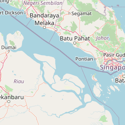
Map view of Pulai River

Use this park location map to pinpoint Pulai River in Malaysia, understand its exact geographic position, and read its mapped placement within the surrounding landscape more clearly.

Pigeon | © OpenStreetMap contributors

Location context for Pulai River

Johor

Visualizing the mangrove forests, tidal estuaries, and coastal wetland habitats of Pulai River

Pulai River Photos and Protected Landscape Scenery

Visual records reveal the diverse terrain and estuarine habitats that define the Pulai River protected area. Photographic documentation allows researchers and explorers to examine the coastal ecosystems and mangrove shorelines more closely.

A wide view of the Pulai River mouth under an overcast sky, with dense mangrove forest on the right bank and industrial shipping cranes visible on the left bank.

A wide, eye level view of a grey, overcast river mouth with mangroves on the right bank and industrial shipping cranes visible on the distant left horizon.

Park atlas

Compare regional protected areas and connected coastal ecosystems next.

Exploring Other Parks Near Pulai River and Surrounding Protected Landscapes

Browse nearby national parks and protected areas sharing similar estuarine geography, mangrove reserves, and tidal habitats. Continuing from Pulai River provides broader context for regional conservation corridors and coastal wetlands.
Nature reserveJohor
About 8.7 km away#1 closest

Southwest

Tanjung Piai Nature Reserve: Geographical Atlas and Coastal Protected Landscape Overview

A Ramsar-designated mangrove sanctuary in Johor, Malaysia.

Tanjung Piai Nature Reserve represents a critical coastal ecosystem at the edge of the Malay Peninsula. This protected area functions as a vital corridor for migratory birds and local marine life, characterized by low-lying mudflats and extensive mangrove stands. The reserve marks the symbolic southern extremity of mainland Asia, balancing conservation priorities with the unique geographic significance of the Johor Strait shoreline.

Visitors
32.4K annual
Relief
Lowland
Climate
Tropical
Scope
Mixed
Watercolor illustration of a mangrove ecosystem with wooden structures over mudflats.
National parkJohor
About 14 km away#2 closest

West

Kukup Island National Park: Mapping the Mangrove Forests and Tidal Geography of Johor

An uninhabited wetland sanctuary on the Strait of Malacca

Kukup Island National Park represents a significant protected area in Johor, Malaysia, known for its near-total cover of dense mangrove forest. This uninhabited island features five tidal river systems and an extensive system of surrounding intertidal mudflats. The park provides an essential geographic case study for coastal wetland ecosystems, supporting migratory waterbird populations and serving as a vital natural coastal barrier within the Strait of Malacca.

Area
4.88 km²
Established
1997
Relief
Lowland
Climate
Tropical
Marine protected areaJohor
About 113 km away#3 closest

Northeast

Sibu Island: Marine Protected Area and Coastal Landscape Analysis

Mapping the coral reefs and pyroclastic terrain of the Johor coast

Sibu Island is a protected marine area in the South China Sea, distinguished by its unique pyroclastic geology and surrounding coral reef ecosystems. This entry provides a structured look at the island's coastal geography, vegetation, and maritime boundaries off the coast of Mersing, Johor. Access detailed geographic context for this tropical landscape.

Area
4.05 km²
Established
1993
Relief
Lowland
Climate
Tropical
National parkJohor
About 117 km away#4 closest

North

Endau-Rompin National Park: Ancient Tropical Rainforest Protected Landscape in Johor, Malaysia

Explore unique mapped geography and ancient geological features.

Endau-Rompin National Park in Johor, Malaysia, is a testament to Earth's ancient history, housing tropical rainforests built upon geological formations around 248 million years old. This protected area offers a detailed look at rugged mountainous terrain, vital river systems, and a diverse mapped landscape, crucial for understanding regional geography and conservation. Its status as one of the oldest rainforest complexes makes it a significant site for exploring the planet's prehistoric natural heritage and protected land distribution.

Area
870 km²
Established
1993
IUCN
II
Relief
Mountain
Protected areaJohor
About 124 km away#5 closest

Northeast

Tinggi Island Protected Area: Geography, Rainforest Terrain, and Johor Coastal Map

Mountainous forest meets extensive coral-rich coastal waters.

Located southeast of Mersing, Tinggi Island is defined by its dramatic silhouette and dense rainforest interior. The protected landscape stretches from the elevated peak of Mount Semundu down to a shoreline of white sand and coastal caves, creating a distinct marine and terrestrial environment unique to the Johor region.

Water
Major water bodies
Season
Year-round
A minimalist watercolor illustration depicting a tropical island coastline with sand beaches, green trees, and rolling hills in the background.
Marine protected areaJohor
About 132 km away#6 closest

North

Besar Island Marine Protected Area: Coastal Geography and Protected Waters in Johor

Mapping the island's reef ecosystems and tropical landscape

Besar Island offers a distinct look at a small-scale marine protected area off the Johor coast. Its geography encompasses a transition from sandy beach fronts to a hilly, jungle-clad interior, all contained within a gazetted two-nautical-mile conservation zone. The surrounding waters support approximately 60 marine species, making this an essential case study for understanding protected marine habitats within the Babi Islands archipelago.

Area
4.77 km²
Relief
Upland
Climate
Tropical
Access
Easy access
A watercolor painting showing layers of soft green and pink rolling hills, with a line of trees in the midground and an open, flat foreground.
Protected areaJohor
About 139 km away#7 closest

North

Rawa Island Protected Area: Coastal Geography and Island Landscape Context in Johor

A protected coral island within the Johor archipelago

Rawa Island serves as a significant protected landscape off the coast of Johor, Malaysia. Defined by its sharp contrast between rocky cliffs and clear, coral-filled waters, the island represents a crucial node in regional island geography. Delve into the spatial characteristics and environmental features of this South China Sea destination through our map-driven atlas framework.

Area
0.23 km²
Water
Water-dominated
Protected areaJohor
About 163 km away#8 closest

Northeast

Pemanggil Island Protected Landscape: Johor Offshore Geography and Island Topography

Mapping coastal features and inland terrain in the South China Sea.

Pemanggil Island serves as a significant geographic landmark within the Mersing cluster of Johor. This detailed atlas entry focuses on the island's structural composition, including its prominent central hill, the rocky interior, and coastal features such as Teluk Lancang. Understand the maritime geography and spatial character of this protected area within the context of the southern Malay Peninsula.

Area
8.82 km²
Relief
Upland
Climate
Tropical
Access
Moderate access

Common questions about visiting, size, designation, and location context for Pulai River

Pulai River FAQs for park facts, access, geography, and protected area context

Find quick answers about Pulai River, including protected-area facts, park geography, trail and visitor context, and how the park fits into its surrounding country and regional landscape.
MoriAtlas Explorer

Continue Your Protected Areas Search Across the Global Atlas

Deepen your exploration by continuing the structured search for national parks and protected areas worldwide. Utilize the comprehensive filtering capabilities to compare different conservation landscapes and refine your understanding of global park geography. Discover more about the distribution and characteristics of protected natural areas.

Global natural geography