

Mori Atlas logo
Nature reserveSusan Island Nature Reserve

Mapping the subtropical lowland rainforest and diverse habitat of the Clarence River

Susan Island Nature Reserve: An Ecologically Significant Protected River Island Landscape

Susan Island Nature Reserve functions as a critical protected remnant of subtropical lowland floodplain rainforest within the Clarence River of New South Wales. This vital river island site supports more than 90 native plant species alongside large seasonal colonies of grey-headed flying foxes. Its alluvial soils and distinct microclimate offer a rare example of dry subtropical forest, recognised for both high ecological value and cultural significance to the Gumbayngirr people.

subtropical lowland rainforestriver islandClarence RiverNorthern Rivers New South Walesfloodplain rainforestgrey-headed flying fox roost

Susan Island Nature Reserve

Nature reserve

Park overview

Structured park overview, official facts, and landscape profile for Susan Island Nature Reserve

Susan Island Nature Reserve park facts, protected area profile, and essential visitor context

Review the core facts for Susan Island Nature Reserve, including designation, size, terrain, visitor scale, habitats, and operating context in one park-focused overview.

About Susan Island Nature Reserve

Susan Island Nature Reserve sits on a long, narrow reach of the Clarence River in the Northern Rivers district of New South Wales, just upstream of the city of Grafton. The reserve covers only about 23 hectares within a 90-hectare river island that stretches roughly three kilometres in length. Although small in size, the reserve is widely regarded as one of the most important lowland rainforest refuges in the Clarence Valley, and it anchors a broader effort to preserve a vegetation type that has been heavily reduced across coastal New South Wales.

The protected area consists of an Endangered Ecological Community of subtropical lowland rainforest growing on floodplain alluvium. This is a rare vegetation formation in the region, with only a handful of comparable remnants remaining; the largest is here on the upstream third of Susan Island, while smaller fragments survive in places such as Coramba Nature Reserve and Maclean Rainforest Reserve. Soils on the island were deposited and reworked by the Clarence River, and the combination of alluvial substrate, riverbank humidity, and around 1,080 millimetres of annual rainfall supports what ecologists describe as a drier, more marginal form of subtropical rainforest. The result is a forest that looks lush but is ecologically fragile, sitting at the edge of its climatic tolerance and easily disturbed by weeds, clearing, and changes in flooding patterns.

Most of the island was historically cleared for timber harvesting, cattle grazing, and even a rifle range, leaving only a fragment of the original rainforest. Recognition of what remained led to formal protection in May 1982 and the beginning of active restoration work by the NSW National Parks and Wildlife Service. Since the late 1980s, managers have focused on suppressing aggressive invasive vines and shrubs such as cat's claw creeper, Dutchman's pipe, moonflower, balloon vine, camphor laurel, and broad-leaved privet, all of which smother native canopy and prevent rainforest regeneration. A long-term replanting and weed-removal program has gradually rebuilt the forest structure, and species such as red cedar, lost when the island was logged out by the 1920s, have been successfully reintroduced.

Ecologically, the reserve is best understood as a layered system of rainforest, river, and animal populations. The island supports a rich bird list that includes white-bellied sea eagles, ospreys, wompoo fruit-doves, noisy pittas, eastern yellow robins, grey fantails, and Lewin's honeyeaters. It is also home to reptiles, additional mammals, and the southernmost known population of Fraser's banded rainforest snail. Most distinctively, it functions as a permanent flying fox camp: the grey-headed flying fox uses the island throughout the year and especially during summer maternity events, while little red flying foxes arrive in surges when nearby eucalypts and hardwoods flower.

Cultural recognition adds a parallel dimension to the reserve's significance. The Gumbayngirr people consider Susan Island a Women's Site with strong spiritual meaning, and the island has been formally declared an Aboriginal Place under NSW national parks legislation. This recognition places the rainforest, the wildlife, and the river setting within a longer Indigenous history of use and meaning that predates European settlement by many generations.

Quick facts and research context for Susan Island Nature Reserve

Susan Island Nature Reserve is a 20-hectare state-protected nature reserve occupying the upstream third of a 90-hectare river island in the Clarence River, near Grafton in northern New South Wales. It was formally reserved in May 1982 and is managed by the NSW National Parks and Wildlife Service under IUCN Category IV management guidelines. The reserve contains the largest remaining example of subtropical lowland floodplain rainforest in the Clarence Valley, with over 94 native rainforest tree and shrub species recorded.

The island functions simultaneously as a rainforest remnant, a migratory and resident wildlife refuge, and an Aboriginal Place of cultural significance. It also serves as a major camp for threatened grey-headed flying foxes, especially during summer when nearby eucalypt forests are in flower.

Protection and recognition

Terrestrial conservation scope, designation history, and formal recognition records

Susan Island Nature Reserve Protection Status and Recognized Designations

Susan Island Nature Reserve maintains a documented terrestrial protection scope within the global conservation registry. Official administrative records outline baseline designation frameworks and international recognition details for the protected area.

Protection details

Protection scope
Terrestrial
Transboundary protection
No
Park context

Deeper park guide and search-rich context for Susan Island Nature Reserve

Susan Island Nature Reserve history, landscape, wildlife, and travel context

Explore Susan Island Nature Reserve through its history, landscape character, ecosystems, wildlife, conservation priorities, cultural context, and seasonal travel timing in a structured park guide built for atlas discovery and search intent.

Why Susan Island Nature Reserve stands out

Susan Island Nature Reserve is best known for two contrasting but connected features: the rare subtropical lowland floodplain rainforest it protects and the enormous seasonal colony of grey-headed flying foxes that roosts and breeds in its canopy. The rainforest itself is unusual because it persists on alluvial river soils under a relatively modest rainfall of around 1,080 millimetres per year, conditions that make this vegetation type especially vulnerable. The site holds more than 90 native rainforest tree and shrub species, including mature Moreton Bay figs, giant stinging trees, and re-established red cedar. At the same time, the island has become one of the more recognised flying fox gathering sites in eastern Australia. During peak summer flowering events in surrounding eucalypt forests, three species of flying fox assemble here in numbers that can reach several hundred thousand, creating one of the largest arboreal mammal aggregations in NSW.
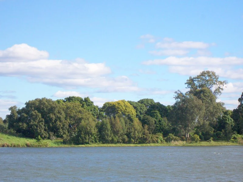
A wide outdoor shot of a river flowing in front of a dense, forested island under a clear blue sky with light clouds.
A view of the riverbanks and dense vegetation of Susan Island on the Clarence River.

Susan Island Nature Reserve history and protected-area timeline

Susan Island has a long history of human use that long predates its formal protection. The Gumbayngirr people regularly visited the island for fishing, hunting, and gathering rainforest foods, medicines, and plant fibres used in making bags and nets. The island carries enduring spiritual significance for the Gumbayngirr community and is recognised as a Women's Site, a reflection of gendered cultural responsibilities connected to the land and the river.

European arrival brought dramatic change. Most of the rainforest on the island was cleared, first through timber harvesting; red cedar in particular was logged from the island until the 1920s, when the accessible supply was exhausted and natural regeneration had effectively ceased. Open land was also used for cattle grazing and for the establishment of Grafton's first rifle range. These activities reduced the original forest to a small remnant concentrated on the upstream third of the island.

Recognition of the surviving rainforest's rarity eventually led to formal protection. In May 1982, the western upstream portion of Susan Island was gazetted as the Susan Island Nature Reserve, placing it under the management of the NSW National Parks and Wildlife Service. From the late 1980s onward, ongoing restoration programs began confronting invasive weeds, beginning with dense prickly pear infestations before expanding to deal with the more aggressive exotic vines that characterise modern riparian weed problems in northern NSW. Red cedar was reintroduced to the island in 2001, marking a symbolic and practical reversal of the early logging era. The site was also formally acknowledged as an Aboriginal Place, embedding its Indigenous cultural significance into its contemporary protected-area identity.

Susan Island Nature Reserve landscape and geographic character

Susan Island is a long, narrow river island in the Clarence River, roughly three kilometres long and about 420 metres wide, oriented along the natural course of one of eastern Australia's larger coastal river systems. The reserve occupies the upstream third of the island, meaning that most of its edges are shaped by the river itself and by the dynamics of Clarence River flooding.

The surface of the island is built from alluvium laid down by the Clarence River. Soils are deep, river-deposited materials that drain freely but remain sufficiently moist to support closed-canopy forest. Rainfall in the area is moderate rather than high, averaging around 1,080 millimetres per year, which is just enough to sustain subtropical rainforest on the margins of its climatic range. This combination of river-built soils and moderate rainfall produces what ecologist A.G. Floyd described as a dry form of subtropical rainforest, floristically rich but sensitive to disturbance.

The visible landscape is a layered canopy of tall trees, including large Moreton Bay figs, forest red gums, tulipwood, lacebark, pepperberry, red bean, black bean, and prominent specimens of yellow kamala and white bean, the latter reaching the southernmost limit of its natural distribution on the island. Beneath the canopy, ferns, palms, vines, and a thick litter layer characteristic of subtropical rainforest create a sheltered, humid microclimate that contrasts strongly with the exposed riverbanks that surround it.

Susan Island Nature Reserve ecosystems, habitats, and plant life

The reserve's most important ecological value is its remnant of subtropical lowland floodplain rainforest, a vegetation community that is now listed as Endangered under New South Wales biodiversity legislation. This forest is structurally complex, with a tall upper canopy of emergent figs and eucalypts, a mid-storey of smaller rainforest trees and shrubs, and a ground layer of ferns and seedlings, supported by alluvial soils and a closed microclimate generated by the canopy itself.

More than 100 native plant species are recorded on the island, of which 94 are rainforest trees and shrubs. The community is significant because floodplain subtropical rainforest of this kind has been extensively cleared across the New South Wales coast for agriculture and timber, leaving the river islands of the Clarence among the few places where intact examples still exist. Susan Island holds the largest such remnant in the Clarence Valley, making it a reference site for the conservation of the broader ecological community.

A defining ecological challenge on the island is invasive vegetation. Exotic vines such as cat's claw creeper, Dutchman's pipe, moonflower, and balloon vine have been particularly destructive in northern NSW riparian zones, forming dense curtains that smother and kill native trees and collapse into the understorey once the canopy fails. Camphor laurel and broad-leaved privet add to the pressure. Active management of these weeds and ongoing replanting have been central to keeping the rainforest from collapsing into a degraded vine thicket.

Susan Island Nature Reserve wildlife and species highlights

Susan Island's wildlife profile is shaped by the overlap of rainforest, river, and open floodplain habitats. Fauna surveys in the late 1990s and 2000s recorded more than 160 bird species, 12 reptile species, and 15 mammal species on the island, indicating a notably high diversity for such a small reserve.

The single most significant animal feature is the grey-headed flying fox colony. The island has been used as a year-round roost and maternity camp for this threatened species since at least the time of European settlement, and in summer the population grows dramatically as other flying fox species arrive to feed on flowering eucalypt forests nearby. Counts at peak times can exceed 100,000 and sometimes surpass 300,000, often swelled by large numbers of little red flying foxes responding to hardwood blossom events. The noise, movement, and ecological impact of these aggregations make Susan Island one of the more prominent flying fox sites along the New South Wales coast.

Birds are a major draw for visitors and researchers. Threatened and notable species recorded on the island include the white-bellied sea eagle and osprey hunting along the river, the wompoo fruit-dove deep in the forest, the notoriously shy and cryptic noisy pitta, and more common residents such as eastern yellow robins, grey fantails, and Lewin's honeyeaters. Reptiles surveyed include several species typical of east coast riverine environments. Among smaller fauna, Susan Island supports the southernmost known population of Fraser's banded rainforest snail, a striking native mollusc whose range terminates here on the Clarence.

Historical accounts of the island at European settlement suggest a richer mammal fauna than the present, with koalas, gliders, and quolls once recorded. Their decline across the broader landscape is consistent with regional patterns, but their absence on the island today helps frame how much the local mammal community has changed over time.

Susan Island Nature Reserve conservation status and protection priorities

Susan Island Nature Reserve matters from a conservation perspective because it protects what is now the largest known example of an Endangered Ecological Community in the Clarence Valley: subtropical lowland rainforest on floodplain alluvial soils. Outside this reserve and a small number of related remnants such as Coramba Nature Reserve and Maclean Rainforest Reserve, this vegetation type has been reduced to fragments too small or too disturbed to fully function as rainforest.

Formal protection in 1982 was the foundation, but the reserve's conservation role depends on active management. Since the late 1980s, the NSW National Parks and Wildlife Service has run a long-term rainforest regeneration program targeting invasive weeds, with particular emphasis on fast-growing exotic vines that have devastated riparian rainforest across northern NSW. Initial work focused on dense stands of prickly pear, but the program has expanded to include cat's claw creeper, Dutchman's pipe, moonflower, balloon vine, camphor laurel, and broad-leaved privet. Parallel restoration efforts have reintroduced red cedar, lost through early logging, and continue to expand the rainforest footprint on the island.

The reserve also has recognised value for threatened fauna. Its grey-headed flying fox population gives it national significance as a maternity and roosting site for a vulnerable species, and its bird and reptile listings include several species of conservation concern. Designation as an Aboriginal Place adds a further dimension, recognising the island's cultural and spiritual values alongside its ecological ones and embedding Indigenous heritage into its management framework.

Susan Island Nature Reserve cultural meaning and human context

Susan Island holds sustained cultural significance for the Gumbayngirr people of the Clarence Valley. The island has been used over many generations for fishing, hunting, and the gathering of rainforest food, medicine, and plant fibres that were woven into bags and nets. Beyond practical use, the island is a place of spiritual meaning, recognised specifically as a Women's Site, reflecting the gendered structure of Gumbayngirr cultural responsibilities toward land, water, and ceremony.

This cultural importance has been formally recognised in contemporary protected-area governance. Susan Island has been declared an Aboriginal Place under the New South Wales National Parks and Wildlife Act, an acknowledgement that integrates Indigenous heritage into the management of the reserve. Together with the rainforest restoration work and the wildlife protection efforts, this designation ensures that the island's meaning to the Gumbayngirr community remains an active part of how the reserve is understood and cared for.

Top sights and standout views in Susan Island Nature Reserve

The reserve's standout features include the largest remaining subtropical lowland floodplain rainforest remnant in the Clarence Valley, the presence of more than 90 species of native rainforest trees and shrubs, and the successful long-term regeneration program that has brought red cedar back to the island after decades of absence.

Equally distinctive is the massive seasonal grey-headed flying fox colony, which can swell from a permanent resident population to gathering of well over 100,000 animals, sometimes reaching several hundred thousand when little red flying foxes join the camp during eucalyptus blossom events. The cultural status of the island as a recognised Aboriginal Place and Women's Site for the Gumbayngirr community adds a final, distinctive layer to a reserve whose value far exceeds its modest area.

Best time to visit Susan Island Nature Reserve

The character of Susan Island changes most visibly through the warmer months, when the flowering of surrounding eucalypt forests triggers the dramatic seasonal influx of flying foxes. Late spring and summer are the period when the island's mammal life is at its most intense, with the canopy alive with movement and the air often carrying the noise of a major camp in full activity. Bird activity remains strong year-round, with resident rainforest species such as the noisy pitta, wompoo fruit-dove, eastern yellow robin, and Lewin's honeyeater offering reliable encounters.

Cooler months tend to bring a quieter atmosphere, with smaller numbers of flying foxes and a calmer feel to both the river and the forest. Rainfall in the Clarence Valley is moderate, but the rainforest interior is sheltered and noticeably more humid under the canopy at any time of year, while the riverbanks remain an accessible vantage point in most seasons.

Monthly climate preview

Long term temperature and precipitation records measured across twelve monthly intervals.

Susan Island Nature Reserve Climate Normals and Annual Weather Patterns

Susan Island Nature Reserve exhibits a measured annual temperature and precipitation rhythm derived from long term representative point data spanning 1991 through 2020. Examining the complete monthly climate normals reveals detailed seasonal variations in average maximum and minimum temperatures alongside daily precipitation averages.
Annual mean20 °C
15 °C25 °C
Jan25°
Feb24°
Mar23°
Apr21°
May18°
Jun16°
Jul15°
Aug16°
Sep18°
Oct20°
Nov22°
Dec24°
Warmest month
January

24.8 °C

Coolest month
July

14.7 °C

Wettest month
February

5.9 mm/day

Driest month
September

1.4 mm/day

Park location guide

Geography guide, regional context, and park location map for Susan Island Nature Reserve

Susan Island Nature Reserve park geography, regions, and map view in Australia

Understand where Susan Island Nature Reserve sits in Australia through a broader geographic reading of the surrounding landscape, nearby location context, and its mapped position within the national park landscape.

How Susan Island Nature Reserve fits into Australia

Australia is a constitutional monarchy and federal parliamentary democracy comprising six states and ten territories. With a population of nearly 28 million, it is one of the world's most urbanised countries, with most people concentrated on the eastern seaboard. The country has a high Human Development Index and is known for its cultural diversity, ancient Aboriginal heritage, and unique wildlife.

Wider geography shaping Susan Island Nature Reserve in Australia

Australia occupies the entire Australian continent, the island of Tasmania, and numerous smaller islands. It is the world's flattest and driest inhabited continent, featuring vast deserts in the interior (the Outback), tropical rainforests along the eastern coast, and a coastline bordering the Indian and Pacific Oceans.

Map view of Susan Island Nature Reserve

Use this park location map to pinpoint Susan Island Nature Reserve in Australia, understand its exact geographic position, and read its mapped placement within the surrounding landscape more clearly.

Pigeon | © OpenStreetMap contributors

Location context for Susan Island Nature Reserve

New South Wales

Visual exploration of floodplain rainforest habitats and riverine terrain

Susan Island Nature Reserve Photos and Landscape Scenery

Examine detailed photographs capturing the dense subtropical canopy, alluvial riverbanks, and unique protected-area environment of Susan Island Nature Reserve. Visual documentation reveals the intricate structure of this rare floodplain rainforest remnant and its vital role as a seasonal wildlife roost.

A wide outdoor shot of a river flowing in front of a dense, forested island under a clear blue sky with light clouds.

Park atlas

Compare regional riverine ecosystems and connected lowland rainforest habitats

Explore Protected Areas and Parks Near Susan Island Nature Reserve

Browse other parks and protected areas near Susan Island Nature Reserve to examine similar floodplain vegetation and river island settings. Continuing this comparison reveals broader ecological patterns across the surrounding Northern Rivers regional landscape.
National parkNew South Wales
About 17 km away#1 closest

North

Fortis Creek National Park: A Protected Valley Landscape in Northern New South Wales

Mapped protected area boundaries and regional geographic context.

Fortis Creek National Park preserves a significant valley and creek environment in northern New South Wales, Australia. Established in 1997, it serves as a protected area safeguarding representative riparian and valley ecosystems. The park's landscape, characterized by draining creek corridors toward the Clarence River basin, offers a glimpse into the natural terrain of eastern Australia, distinct from more commonly known coastal or alpine regions.

Area
78 km²
Established
1997
IUCN
II
Scope
Terrestrial
National parkNew South Wales
About 19 km away#2 closest

West

Ramornie National Park: National Park Discovery and Geographic Mapping in New South Wales

Explore its mapped boundaries and regional protected landscape identity.

Ramornie National Park stands as a distinct national park within New South Wales, offering users a focal point for understanding protected area geography. This page provides essential atlas-level context, detailing the park's mapped outlines and its placement within the broader regional landscape of Australia. Engage with the core geographic identity of Ramornie National Park, designed for structured discovery and landscape analysis without any operational details.

Area
31.6 km²
Established
1999
IUCN
II
Relief
Lowland
National parkNew South Wales
About 28 km away#3 closest

West

Nymboida National Park: A Protected National Park in New South Wales with Mapped Geographic Context

Explore its protected landscape and regional park geography

Nymboida National Park is a key protected area within the state of New South Wales, Australia. This page provides essential details for atlas exploration, focusing on its mapped boundaries and the geographic context it occupies. Understand the park's identity as a national park and its contribution to the protected landscape of the region, offering insights into its natural terrain and regional distribution.

Area
316 km²
Established
1980
IUCN
Ib
Relief
Mountain
National parkNew South Wales
About 29 km away#4 closest

Southeast

Yuraygir National Park: New South Wales Protected Area Geography and Landscape Atlas

Discover mapped boundaries and natural terrain context.

Delve into the detailed geography of Yuraygir National Park, a protected natural landscape in New South Wales, Australia. This entry provides core atlas-relevant information, focusing on its mapped protected area boundaries and the intrinsic geographic character of the region, essential for understanding its place in conservation landscapes.

Area
313.71 km²
Established
1980
IUCN
II
Climate
Temperate
National parkNew South Wales
About 38 km away#5 closest

South

Nymboi-Binderay National Park: Protected Landscape in New South Wales

Explore its mapped boundaries and regional natural geography.

Nymboi-Binderay National Park stands as a protected natural landscape within New South Wales, Australia, offering valuable geographic context for atlas explorers. This entry focuses on its identity as a national park, providing insights into its mapped protected area and its position within the broader regional geography of New South Wales, enabling structured discovery of its natural landscape features.

Area
172.43 km²
Established
1997
IUCN
II
Relief
Upland
National parkNorthern Tablelands
About 39 km away#6 closest

Southwest

Chaelundi National Park: Landmark Old-Growth Forest Protection in the Northern Tablelands

Mapped protected area landscape and regional geography.

Chaelundi National Park stands as a vital component of protected natural landscapes on Australia's Northern Tablelands. This national park is celebrated for its extensive old-growth forest, a direct result of significant environmental legal battles that highlighted its ecological importance. With declared wilderness areas covering thousands of hectares, the park offers a substantial glimpse into the region's conservation values and the complex interplay between landscape, law, and protected land status, providing rich context for geographic exploration.

Area
191.74 km²
Established
1997
IUCN
II
Relief
Highland
National parkNew South Wales
About 39 km away#7 closest

West

Gibraltar Range National Park: New South Wales Protected Landscape Explorer

Mapped park boundaries and regional geography of a key national park.

Delve into the protected landscape identity of Gibraltar Range National Park, a significant national park situated in New South Wales. This page offers detailed insights into its mapped boundaries and its place within the broader regional geography. Understanding Gibraltar Range National Park provides essential context for exploring Australia's network of protected areas and appreciating the diverse natural terrain it safeguards.

Area
253 km²
Established
1987
IUCN
Ib
Relief
Mountain
Watercolor painting showing a coastal landscape with a body of water, trees, and distant hills under a soft pastel sky
National parkNew South Wales
About 49 km away#8 closest

Northeast

Bundjalung National Park: New South Wales Protected Landscape Atlas Entry

Explore its unique coffee rock formations and Bundjalung heritage.

Bundjalung National Park is a significant protected area on the coast of New South Wales, Australia, renowned for its distinctive coffee rock formations and coastal heathland ecosystems. This park offers a rich landscape for atlas exploration, showcasing unique geological features along its beaches and headlands. Understanding its geography and protected boundaries provides crucial context for appreciating its natural and cultural significance within the broader regional landscape.

Area
210 km²
Established
1980
IUCN
II
Relief
Lowland

Common questions about visiting, size, designation, and location context for Susan Island Nature Reserve

Susan Island Nature Reserve FAQs for park facts, access, geography, and protected area context

Find quick answers about Susan Island Nature Reserve, including protected-area facts, park geography, trail and visitor context, and how the park fits into its surrounding country and regional landscape.
MoriAtlas Explorer

Continue Your Protected Areas Search Across the Global Atlas

Deepen your exploration by continuing the structured search for national parks and protected areas worldwide. Utilize the comprehensive filtering capabilities to compare different conservation landscapes and refine your understanding of global park geography. Discover more about the distribution and characteristics of protected natural areas.

Global natural geography