Mori Atlas logo
Wildlife reserveTajzara

Mapping the saline lagoons and high-Andean aquatic ecosystems across this arid plateau refuge

Tajzara Wildlife Reserve: A High Altitude Andean Wetland Landscape in Tarija Department, Bolivia

Tajzara Wildlife Reserve encompasses a distinct system of shallow saline lakes and marshes situated on the arid high-altitude plateau of the Bolivian Andes. Within the Tarija Department, this protected area features seasonal pools such as Laguna Grande and Laguna Chica that sustain birdlife amidst an otherwise harsh intermontane basin. This atlas entry provides an overview of the terrain, boundaries, and hydrological characteristics that define this significant Ramsar site in the Cordillera de Sama region.

altiplano wetlandsaline lakeshigh-altitude ecosystemflamingo habitatRamsar siteAndean birdlife

Tajzara

Wildlife reserve

Park overview

Structured park overview, official facts, and landscape profile for Tajzara

Tajzara park facts, protected area profile, and essential visitor context

Review the core facts for Tajzara, including designation, size, terrain, visitor scale, habitats, and operating context in one park-focused overview.

About Tajzara

Tajzara is a high-altitude lake and wetland complex on the Bolivian Altiplano, in the Tarija Department near the Cordillera de Sama. Nestled in an arid intermontane basin at elevations between roughly 3700 and 3800 meters above sea level, it forms one of the most ecologically significant wetland oases on the southern Bolivian high plain. The system includes the permanent lakes of Pujzara, Laguna Grande, and Laguna Chica, along with eight additional smaller lagoons and pans that fill and dry in response to seasonal rainfall.

Water levels at Tajzara fluctuate notably throughout the year and across multi-year cycles of approximately four to eight years. During rainy periods, the combined surface area can expand to around 13 square kilometers, while in drier conditions the system contracts to a much smaller footprint. The lakes are fed by small rivers and streams from the surrounding highlands, including the Tajzara, Vicuña Yojo, Munia Yojo, Tucarmarka, and Toro Waikho. The water is saline, and the lake beds are layered with fine silt, supporting the productivity that attracts Tamad waterbird communities.

The site's importance extends well beyond its local setting. Tajzara is integrated into the protected landscape of the Cordillera de Sama Biological Reserve and was designated a Ramsar wetland site in 1999, recognizing its international value for the conservation of high-Andean aquatic ecosystems. Together with nearby reserves, it forms part of a network of protected areas safeguarding the unique ecosystems of the Bolivian Andes.

Quick facts and research context for Tajzara

Tajzara lies on the arid Altiplano of southern Bolivia, in the Tarija Department within the province of José María Avilés. The wetland system comprises permanent lakes and seasonal pools situated between roughly 3700 and 3800 meters above sea level, fed by small rivers and streams descending from the surrounding highlands.

The broader Tajzara basin is recognized as a Ramsar site of international importance under the Ramsar Convention, and it forms part of the protected landscape surrounding the Cordillera de Sama Biological Reserve. The system is one of the most important refuges for Andean aquatic birds in Bolivia and a key site for high-altitude flamingos and migratory waders.

Protection and recognition

Documented terrestrial protection framework established in 1999

Tajzara Protection Status and Designated Conservation History

Tajzara maintains a documented terrestrial protection status established in 1999 across its regional landscape. Structured records outline the official designation history and management scope without imported international recognition sources.

Protection details

Protection scope
Terrestrial
Designated year
1999
Transboundary protection
No
Park context

Deeper park guide and search-rich context for Tajzara

Tajzara history, landscape, wildlife, and travel context

Explore Tajzara through its history, landscape character, ecosystems, wildlife, conservation priorities, cultural context, and seasonal travel timing in a structured park guide built for atlas discovery and search intent.

Why Tajzara stands out

Tajzara is best known as one of the most important high-Andean wetland complexes in Bolivia, providing habitat for three species of flamingos, including Andean flamingos and James's flamingos, as well as horned coots and a substantial share of Bolivia's high-altitude aquatic birdlife. The site represents a rare concentration of life in an otherwise arid Andean landscape, drawing waterbirds to its saline lagoons and seasonally flooded flats.
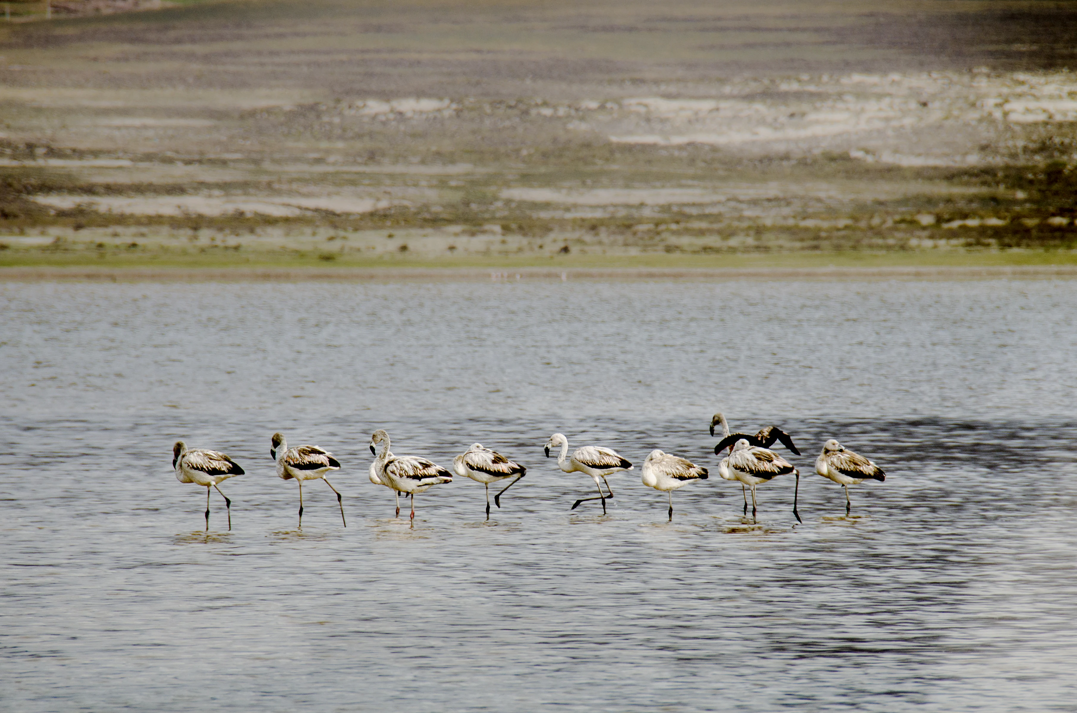
A group of eight flamingos standing in shallow, rippled water with a desert shoreline in the background.
A small flock of flamingos wading in the shallow waters of Laguna de Tajzara.

Tajzara history and protected-area timeline

Formal recognition of the Tajzara basin came in 1999, when the area was designated a Ramsar site for its importance as a wetland of international significance. This designation highlighted the basin's biological diversity and established its role within the international network of protected wetlands, complementing the nearby Cordillera de Sama Biological Reserve, which strengthens the broader conservation context of the region.

Tajzara landscape and geographic character

Tajzara sits within a high-altitude basin on the arid Altiplano, framed by the surrounding ridges of the Andes and the Cordillera de Sama. Elevations across the system range from roughly 3700 to 3800 meters, and the broader plateau receives limited precipitation, averaging about 307 millimeters per year. The mean annual temperature is around 6.4 degrees Celsius, reflecting the cold, dry conditions typical of the high Andes.

The wetland itself is shaped by shallow lakes, salt flats, marshy margins, and seasonal pools connected to small highland rivers. Saline conditions and silty lake bottoms define the substrate of the lagoons, while the alternation between wet and dry seasons produces a dynamic landscape that expands and contracts with rainfall. The contrast between the barren plateau and the life-sustaining wetlands is one of the most striking features of the setting.

Tajzara ecosystems, habitats, and plant life

Despite the aridity of the surrounding plateau, the Tajzara basin supports a rich mosaic of wetland habitats, including saline open-water lagoons, shallow marshy margins, reed-fringed shorelines, and ephemeral pools that fill during the rainy season. These habitats, rare on the otherwise dry Altiplano, sustain a disproportionate share of the high-Andean biodiversity of the region.

The vegetation is adapted to the cold, saline, and intermittently wet conditions typical of high-altitude Andean wetlands, forming transitional zones between aquatic and terrestrial ecosystems. Marshes and reedbeds along the lake margins provide shelter and feeding areas for waterbirds, while the surrounding plains host hardy Andean flora adapted to the harsh climate.

Tajzara wildlife and species highlights

The Tajzara basin holds exceptional significance for high-Andean birds, hosting approximately 41 waterbird species associated with the high Andes, which together account for around 90 percent of the aquatic birdlife in Bolivia's high plateau ecosystems. The lakes are particularly important for migratory waders that pass through the region on their seasonal journeys.

The site is one of the principal strongholds for Andean flamingos, James's flamingos, and horned coots, all of which are species of conservation concern. Dense flocks of Andean gulls, various ducks, and other waterfowl also concentrate at the lagoons throughout the year. Small fish populations inhabit the lakes, including species such as Oligosarcus bolivianus, Acrobrycon tarijae, the two-spotted astyanax, and Plecostomus borelli, supporting the broader aquatic food web.

Tajzara conservation status and protection priorities

Tajzara is recognized internationally as a wetland of outstanding biological value, and in 1999 the basin was designated a Ramsar site under the Ramsar Convention on Wetlands. This designation affirms the site's global importance as a refuge for migratory birds and high-Andean waterbird communities. Its inclusion within the broader landscape of the Cordillera de Sama Biological Reserve strengthens its protected status and connects it to a wider network of Andean conservation areas.

The conservation significance of Tajzara lies not only in the birdlife it supports but also in its role as a biodiversity hotspot in an otherwise arid environment. Its saline lakes, seasonal hydrological cycles, and fish populations contribute to a fragile and distinctive ecosystem whose preservation is tied closely to the larger ecological integrity of the Bolivian Altiplano.

Top sights and standout views in Tajzara

Tajzara's most prominent highlights include its Ramsar designation, its populations of Andean flamingos and James's flamingos, and its importance for migratory waders and horned coots. The contrast between its arid high-altitude setting and its thriving aquatic life, combined with its integration into the Cordillera de Sama conservation landscape, makes it one of the most distinctive wetland systems of the Bolivian Andes.

Best time to visit Tajzara

The character of Tajzara shifts strongly with the seasonal rains, which expand the lagoons and increase bird activity. Visiting during or after the rainy season offers the best conditions for observing large concentrations of waterbirds, including flamingos, while drier periods produce smaller, more saline lagoons. The cool high-altitude climate means conditions can be harsh year-round, with average temperatures around 6 degrees Celsius.
Monthly climate preview

Track monthly precipitation averages and historical temperature ranges for Tajzara

Tajzara Climate Normals and Long Term Temperature Patterns

Tajzara experiences a measured annual temperature and precipitation rhythm defined by long term records from a representative high altitude coordinate. Exploring the complete twelve month climate profile reveals detailed monthly variations across temperature extremes and precipitation rates.
Annual mean11 °C
7 °C14 °C
Jan14°
Feb14°
Mar13°
Apr12°
May
Jun
Jul
Aug
Sep11°
Oct13°
Nov14°
Dec14°
Warmest month
December

14.5 °C

Coolest month
July

7.2 °C

Wettest month
January

5.1 mm/day

Driest month
July

0.4 mm/day

Park location guide

Geography guide, regional context, and park location map for Tajzara

Tajzara park geography, regions, and map view in Bolivia

Understand where Tajzara sits in Bolivia through a broader geographic reading of the surrounding landscape, nearby location context, and its mapped position within the national park landscape.

How Tajzara fits into Bolivia

Bolivia, officially the Plurinational State of Bolivia, is a landlocked country in central South America. It features diverse geography including the Andean mountain range, Amazonian plains, Gran Chaco, and the Pantanal wetland. The country has a population of approximately 11.4 million and is administratively divided into nine departments, with La Paz as the seat of government and Sucre as the constitutional capital.

Wider geography shaping Tajzara in Bolivia

Bolivia is located in central South America, bordered by Brazil to the north and east, Paraguay to the southeast, Argentina to the south, Chile to the southwest, and Peru to the west. The country is divided between a western Andean region and tropical lowlands to the east and north. It includes the Amazonian plain, Gran Chaco, temperate valleys, the high-altitude Altiplano plateau, and part of the Pantanal wetland along its eastern border.

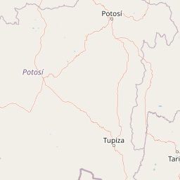
Map view of Tajzara

Use this park location map to pinpoint Tajzara in Bolivia, understand its exact geographic position, and read its mapped placement within the surrounding landscape more clearly.

Pigeon | © OpenStreetMap contributors

Location context for Tajzara

Tarija Department

Visual reference collection showcasing high-altitude wetlands, saline lagoons, and protected Andean habitats.

Tajzara Landscape Photos and Altiplano Scenery Visual Explorer

Visual documentation of Tajzara reveals the striking contrast between arid plateau terrain and life-sustaining wetland basins. Exploring these protected-area photographs helps researchers and travelers understand the high-altitude ecosystem, saline water bodies, and avian habitats of the region.

A group of eight flamingos standing in shallow, rippled water with a desert shoreline in the background.

Park atlas

Compare high altitude wetland reserves and surrounding Andean mountain terrain

Explore Protected Areas and Parks Near Tajzara in the Bolivian Altiplano

Browse protected areas near Tajzara to discover connected high altitude ecosystems and saline lake basins across the surrounding region. Comparing these regional conservation landscapes reveals broader geographic patterns in the arid plateau.
A watercolor painting of a simplified, abstract landscape with rolling hills in shades of green, yellow, and muted pink against a white background.
Protected landscapeTarija
About 11 km away#1 closest

North

Parque natural y área de manejo integrado El Cardón: Geography and Protected Area Atlas

High-altitude puna landscapes and cactus diversity in Tarija, Bolivia.

Spanning the high-altitude plateaus of southern Bolivia, this protected area features a unique mosaic of arid terrain, specialized cactus ecosystems, and vital wildlife corridors. The landscape provides a deep look into the puna and pre-puna geography of the Tarija department, including significant archaeological sites and thriving populations of wild vicuñas within a dramatic, high-elevation Andean environment.

Area
300.56 km²
Established
2003
Relief
Mountain
Climate
Arid
Watercolor illustration showing a pale green rural landscape with rolling hills, scattered trees, a winding path or stream, and small buildings in the distance
Biosphere reserveBolivia
About 20 km away#2 closest

Northeast

Reserva Biológica de la Cordillera de Sama: Protected Mountain Landscapes of Southern Bolivia

High-Andean biosphere reserve featuring lagoons, dunes, and ancient pathways.

Reserva Biológica de la Cordillera de Sama encompasses a vast elevation range from dry inter-Andean valleys to the 4,700-meter peaks of the Cordillera Oriental. This reserve protects the endorheic Tajzara basin, where seasonal lagoons and sand dunes contrast with relict forests and steep mountain ravines. Its geography offers a complex mosaic of ecosystems, providing essential water sources and specialized habitat for endemic fauna within the southern Bolivian highlands.

Area
1,085 km²
Established
1991
Relief
Mountain
Climate
Alpine
Protected areaPotosí
About 58 km away#3 closest

Southwest

Pampa Tholar de las Vicuñas: Protected Andean Puna Landscapes and Geographic Overview

Integrated management area and high-altitude habitat in Potosí, Bolivia.

Pampa Tholar de las Vicuñas covers nearly 60,000 hectares of arid puna in the municipality of Villazón, representing a key intersection of biodiversity and local pastoral traditions. The area features a complex mosaic of piedmont slopes, rolling foothills, and seasonal water networks that provide essential habitat for the Andean condor and large vicuña populations. This protected landscape offers a unique look at high-altitude land management in the transitional zone between the Altiplano and the Eastern Cordillera.

Area
584.8 km²
Established
2018
Relief
Highland
Climate
Arid
A soft watercolor painting depicting gentle, rolling hills and plains in muted shades of green, yellow, and violet.
Natural monumentSud Chichas
About 75 km away#4 closest

West

Área protegida municipal Ecoparque Encantado: Geographic Atlas and Natural Monument Overview

Mapped canyon landscapes and dry valley geography in the Sud Chichas province.

Analyze the topographic features of Área protegida municipal Ecoparque Encantado, a protected municipal monument in southern Bolivia. This area captures the dramatic transition between high-altitude puna grasslands and warm inter-Andean dry valleys. Learn about the geological history of the Tupiza Formation, the preservation of endemic vegetation, and the specific terrain dynamics that define this unique canyon-rich protected landscape.

Area
38.2 km²
Established
2015
IUCN
III
Relief
Mountain
A soft watercolor illustration of a river flowing through a lush landscape with gentle green hills in the distance.
Wildlife reserveTarija
About 81 km away#5 closest

East

Reserva nacional de flora y fauna de Tariquía: Atlas and Geographic Protected Area Overview

Montane cloud forest and subandean river valleys in Tarija

This wildlife reserve preserves the most intact stands of Yungas Tucumano-Boliviano forest in Bolivia. Featuring a dramatic vertical zonation from foothill selva to high-elevation pine woodlands, the area serves as a primary hub for ecological research and conservation in the rugged landscapes of Tarija near the Argentine border.

Area
2,468.7 km²
Established
1989
Relief
Mountain
Climate
Subtropical
National parkArgentina
About 84 km away#6 closest

South

Baritú National Park National Park: Mapped Protected Landscapes in Argentina's Geography

Understand the natural terrain and geographic setting of this Argentinian park.

Baritú National Park represents a distinct national park entity within Argentina, crucial for understanding the country's protected landscapes and regional geography. This page provides specific atlas-level detail on its mapped boundaries and the surrounding natural terrain. Explore Baritú National Park as a key geographic feature contributing to the broader understanding of conservation areas across South America, grounded in factual, map-oriented discovery.

Area
720 km²
Established
1974
IUCN
II
Relief
Mountain
Protected areaGran Chaco Province
About 154 km away#7 closest

East

Aguaragüe National Park and Integrated Management Natural Area: Bolivia's Easternmost Sub-Andean Protected Landscape

Explore its mapped mountain geography and ecological diversity.

Aguaragüe National Park and Integrated Management Natural Area is a crucial protected area in Bolivia's Gran Chaco Province, defined by the Serranía del Aguaragüe mountain range. This landscape offers a unique opportunity to explore a geographic transition zone where Southern Andean Yungas montane forests converge with Dry Chaco ecosystems. The park's protected boundaries encompass a rugged mountain backbone rising from the lowlands, representing a vital segment of Bolivia's Sub-Andean geography and protected natural areas.

Area
1,083.07 km²
Established
2000
IUCN
II
Relief
Mountain
National parkArgentina
About 196 km away#8 closest

South

Calilegua National Park: Mapped Protected Landscape in Argentinian Geography

Explore the national park's boundaries and regional terrain.

Calilegua National Park represents a vital protected landscape within Argentina's extensive geography. This detail page provides an atlas-focused view, highlighting the park's specific geographic setting and its importance as a national park. Understand its mapped terrain and how it fits within the broader conservation context of South America. This resource is crafted for in-depth geographic discovery and map-based analysis of the park's protected area features.

Area
763.06 km²
Established
1979
IUCN
II
Relief
Mountain

Common questions about visiting, size, designation, and location context for Tajzara

Tajzara FAQs for park facts, access, geography, and protected area context

Find quick answers about Tajzara, including protected-area facts, park geography, trail and visitor context, and how the park fits into its surrounding country and regional landscape.
MoriAtlas Explorer

Continue Your Protected Areas Search Across the Global Atlas

Deepen your exploration by continuing the structured search for national parks and protected areas worldwide. Utilize the comprehensive filtering capabilities to compare different conservation landscapes and refine your understanding of global park geography. Discover more about the distribution and characteristics of protected natural areas.

Global natural geography