
Mori Atlas logo
Nature reserveTäler und Verlandungszone am Gelterswoog

Examining the ecological mosaic of lakes, peat-forming mires, and forested stream valleys

Täler und Verlandungszone am Gelterswoog: A Protected Nature Reserve and Wetland Landscape

(Naturschutzgebiet Täler und Verlandungszone am Gelterswoog)

Täler und Verlandungszone am Gelterswoog serves as a critical protected refuge within the broader Palatinate Forest of Rheinland-Pfalz. This compact nature reserve preserves an intricate connection of open water, active shorelines, and shaded stream valleys like the Walkmühltal and Kolbental. The area functions as a vital corridor for freshwater biodiversity, particularly supporting threatened dragonfly populations within its varied wetland habitats.

freshwater habitatslake shorelinepaludification zonepeatlandmiresstream valleys
A stylized flat vector illustration of a lake reflecting a forested shoreline under a soft, pastel-colored sky.

Täler und Verlandungszone am Gelterswoog

Nature reserve

Park overview

Structured park overview, official facts, and landscape profile for Täler und Verlandungszone am Gelterswoog

Täler und Verlandungszone am Gelterswoog park facts, protected area profile, and essential visitor context

Review the core facts for Täler und Verlandungszone am Gelterswoog, including designation, size, terrain, visitor scale, habitats, and operating context in one park-focused overview.

About Täler und Verlandungszone am Gelterswoog

Täler und Verlandungszone am Gelterswoog is a focused, ecologically driven nature reserve in the southwestern German state of Rhineland-Palatinate. It is located on the southwestern edge of Kaiserslautern, where the urban landscape meets the northern reaches of the Palatinate Forest and its associated UNESCO-recognized Biosphere Reserve. The name itself describes the reserve's two central landscape themes: small valleys (Täler) carved by streams, and a lakeside overgrowth or paludification zone (Verlandungszone), where open water is gradually being colonized by marsh and bog vegetation.

The reserve's core is the western shoreline of the Gelterswoog, an artificial lake embedded in forested terrain that has long been valued locally for recreation. Around this anchoring lake habitat, the protected area extends to include additional, smaller wetland features: the Kolbenwoog, a small lake roughly one kilometer to the northwest in the Kolbental valley, and the adjacent Kolbenmoor, itself an important element of the reserve's peatland character. Three stream-cut valleys are also incorporated, among them the Walkmühltal and the Kolbental, whose steep, wooded slopes and narrow watercourses create a sharply different microclimate from the open lakeshore.

Together these elements form a compact but unusually diverse protected landscape. Within a single reserve, visitors and researchers can find still water, actively reforming lake shore, acidic peatland, and shaded forest streams. This diversity is the reason the site has been protected as a Naturschutzgebiet and is the basis for its continued ecological importance.

The reserve sits within a much broader network of protected areas that characterize the Kaiserslautern region. It is listed alongside neighboring Naturschutzgebiete such as the Aschbachtal-Jagdhausweiher, the Östliche Pfälzer Moorniederung, and the Vogelwoog-Schmalzwoog, all of which share the same underlying mission of safeguarding small-scale freshwater, bog, and forest habitats that would otherwise be vulnerable to woodland drainage, land use change, or recreational pressure.

Quick facts and research context for Täler und Verlandungszone am Gelterswoog

Täler und Verlandungszone am Gelterswoog lies in Rhineland-Palatinate (Rheinland-Pfalz), on the territory of the city of Kaiserslautern and the surrounding Landkreis Kaiserslautern, on the edge of the Palatinate Forest Biosphere Reserve.

It has been a designated Naturschutzgebiet since 1997 and is recorded in the World Database on Protected Areas under the identifier 165817. The reserve combines the western lakeshore of the Gelterswoog with marginal mires, small satellite waters such as the Kolbenwoog and Kolbenmoor, and three stream-cut valleys including the Walkmühltal and the Kolbental.

Protection and recognition

Documented conservation parameters, administrative scope, and recognized data records

Täler und Verlandungszone am Gelterswoog Protection Status and WDPA Records

Examine the recorded protection status and official database identifiers for Täler und Verlandungszone am Gelterswoog through structured atlas parameters. Protected area metrics provide transparent administrative tracking without speculative conservation claims.

Protection details

WDPA ID
165817
Park context

Deeper park guide and search-rich context for Täler und Verlandungszone am Gelterswoog

Täler und Verlandungszone am Gelterswoog history, landscape, wildlife, and travel context

Explore Täler und Verlandungszone am Gelterswoog through its history, landscape character, ecosystems, wildlife, conservation priorities, cultural context, and seasonal travel timing in a structured park guide built for atlas discovery and search intent.

Why Täler und Verlandungszone am Gelterswoog stands out

The reserve is best known for its concentration of rare and threatened dragonflies, which use the lake margins, mires, and small valley streams as essential breeding and hunting habitat. Several species that are endangered in Germany, including the Spear Azure Damselfly, the Banded and Blauflügel Prachtlibelle, the Small Blue-tail, the Green Hawker, and the Two-striped Spring Dragonfly, still occur here in notable numbers. Beyond the dragonflies, the reserve is valued for the unusual combination of ecological zones it conserves within a compact footprint: still water, actively forming lake-edge mires, peat moorland, and narrow, shaded stream valleys. This mosaic of small freshwater and wetland habitats is the defining ecological feature of the protected area.
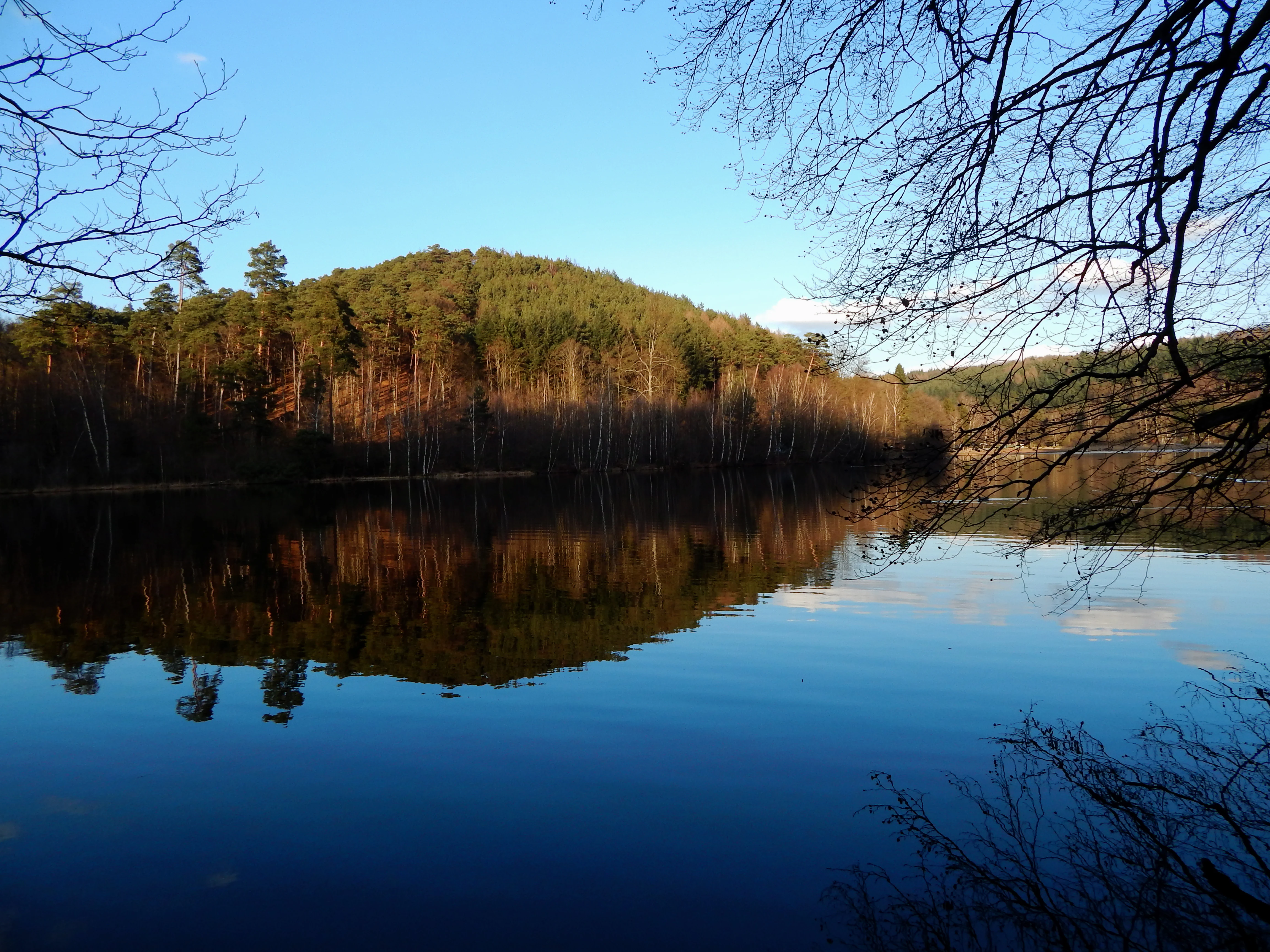
A serene lake view with dark blue water reflecting a tree-covered hill under a clear blue sky, framed by out-of-focus tree branches in the foreground.
The tranquil waters of the Gelterswoog lake reflect the surrounding forested hills of the Palatinate Forest.

Täler und Verlandungszone am Gelterswoog history and protected-area timeline

The history of Täler und Verlandungszone am Gelterswoog as a formal protected area begins in 1997, when the site was designated as a Naturschutzgebiet under Rhineland-Palatinate nature conservation law. The designation recognized the ecological value of the Gelterswoog lakeshore and its associated moors and valleys at a time when the broader Pfälzerwald region was gaining formal recognition for its landscape and biodiversity significance.

The reserve as a whole builds on a longer, implicit history of the Gelterswoog itself as a local landscape feature. The lake and its surrounding forests have long been part of the recreational and cultural landscape around Kaiserslautern, lying at the interface between the city and the forested uplands of the Palatinate. The 1997 designation transformed this implicit cultural landscape value into an explicit ecological protection framework, securing the lakeshore, its overgrowth zone, and three stream valleys against incompatible land uses.

Since its designation, the reserve has not undergone major visible renamings or boundary reorganizations documented in the available sources. Its narrative is therefore less about institutional change and more about continuity: a small but well-chosen set of habitats whose legal protection has allowed sensitive species, especially dragonflies and bog-associated plants, to persist in a region otherwise dominated by commercial forest.

Täler und Verlandungszone am Gelterswoog landscape and geographic character

The landscape of the reserve is defined above all by water and the transitions around water. The Gelterswoog itself is a small, forested lake whose western shore forms the reserve's central feature. Along this shore, the typical lake-margin processes of central Europe are visible: reed belts, shallow-water vegetation, and gradually encroaching bog surfaces where open water is being replaced by wet peat-forming communities. This Verlandungszone, the slowly closing lake edge, is one of the defining landscape elements and gives the reserve part of its name.

Surrounding and inland from the lake, the terrain rises into forested slopes. The Walkmühltal and the Kolbental are narrow, sharply cut stream valleys that cut back into the surrounding hills, bringing steep slopes, mossy boulder fields, shaded brooks, and damp leaf litter into close proximity with the lake and bog habitats. The Kolbenwoog, a smaller water body in the Kolbental, acts as a satellite lake system, while the neighboring Kolbenmoor adds open, peat-dominated ground to the reserve's profile.

The result is a landscape of small-scale contrasts: open reflective water next to dense reed beds, dark coniferous and mixed forest above wet hay-scented hollows, sunlit bog surfaces beside deeply shaded stream gullies. These contrasts, packed into a relatively small protected footprint, are what shape both the visual character and the ecological richness of the area.

Täler und Verlandungszone am Gelterswoog ecosystems, habitats, and plant life

Ecologically, the reserve sits at the intersection of three habitat worlds: open freshwater, paludification and bog, and narrow forested stream valley. The lake and its gradually closing margins create a transition from open water through reed and sedge zones into raised bog and moor communities, shaped by centuries of shoreline dynamics and influenced by the local climate of the northern Palatinate highlands.

The peatland component is particularly important. The Kolbenmoor and the Verlandungszone along the Gelterswoog support bog vegetation typical of upland central Europe, including moss-rich surfaces and wetland plant communities that, in much of the region, have been lost to drainage or afforestation. The adjacent valleys, especially the Walkmühltal and the Kolbental, add a strong forest-stream element, with shaded, humidity-loving plant communities lining the small brooks and seeps.

Taken together, these habitats create an unusually complete small-scale wetland-forest mosaic. The reserve functions less as a single habitat than as a network of closely linked microhabitats, where dragonflies, amphibians, bog plants, and forest-stream species can each find the conditions they need across very short distances.

Täler und Verlandungszone am Gelterswoog wildlife and species highlights

The reserve's wildlife profile is most distinctive in its dragonfly fauna, which is the principal reason the area has been highlighted for protection. Several dragonfly species that are considered threatened in Germany still occur here in appreciable numbers, reflecting the quality of the shoreline, bog, and stream habitats.

Among the key species documented in the reserve are the Spear Azure Damselfly (Speer-Azurjungfer), the Banded Prachtlibelle (Gebänderte Prachtlibelle), and the Blauflügel-Prachtlibelle (Blauflügel-Prachtlibelle), along with the Small Blue-tail (Kleiner Blaupfeil), the Green Hawker (Grüne Mosaikjungfer), and the Two-striped Spring Dragonfly (Zweigestreifte Quelljungfer). The presence of this assemblage in a single, small protected area is unusual and indicates that the reserve is functioning as an effective refuge for freshwater invertebrate diversity.

Beyond dragonflies, the reserve's combination of bog, shoreline, and damp forest habitat supports the broader Palatinate Forest wildlife community typical of such mosaics, including amphibians associated with still water and bog, wetland-linked birdlife along the lake edge, and forest-stream fauna in the valleys. The reserve is not framed as a charismatic megafauna site; rather, its conservation significance lies in the small, often overlooked species groups that depend on intact freshwater and peatland systems to survive.

Täler und Verlandungszone am Gelterswoog conservation status and protection priorities

Conservation significance at Täler und Verlandungszone am Gelterswoog is grounded in the protection of a compact, ecologically rich set of habitats rather than in any single flagship species. The reserve safeguards an active Verlandungszone along the western shore of the Gelterswoog, the associated Kolbenwoog and Kolbenmoor, and three stream-cut valleys that together form a functional wetland-and-stream network within the broader forested landscape of the Palatinate.

The reserve's designation in 1997 recognizes that, even within a heavily forested region like the Pfälzerwald, small-scale freshwater and peatland features require explicit protection. Such habitats are particularly vulnerable to hydrological change, recreational pressure around the lake, and the gradual loss of natural shoreline dynamics. By formally protecting the western shore and its inland extensions, the reserve maintains the ecological processes that allow reedbeds, bogs, and stream communities to continue functioning.

The site's importance is reinforced by its place in the regional protected-area network. It is listed alongside neighboring Naturschutzgebiete in Kaiserslautern and the surrounding district, including the Östliche Pfälzer Moorniederung and the Vogelwoog-Schmalzwoog, and lies within the broader Pfälzerwald Biosphere Reserve, a UNESCO-recognized landscape. Together, these overlapping designations place even a small reserve like this one within a regional strategy for preserving freshwater, bog, and forest-stream biodiversity.

Top sights and standout views in Täler und Verlandungszone am Gelterswoog

The reserve's strongest points of distinction lie in the combination of habitats it protects at a single location: still open water, an actively developing Verlandungszone, peat-forming moorland, and narrow forested valleys. This small-scale mosaic is the structural backbone of the area's significance.

Equally important is the reserve's documented dragonfly fauna. The continued presence of several threatened dragonfly species, including the Spear Azure Damselfly, Banded and Blauflügel Prachtlibelle, Small Blue-tail, Green Hawker, and Two-striped Spring Dragonfly, gives the site a clear identity as a refuge for freshwater invertebrate diversity in the northern Palatinate Forest.

Best time to visit Täler und Verlandungszone am Gelterswoog

Late spring through summer is the natural high season of interest at the reserve. Warmer months bring the dragonfly fauna into its most active phase, when the rare species for which the area is known are most likely to be observed around the lake margins, bogs, and sunny stream reaches. Vegetation along the shoreline and in the bog areas is also at its most expressive during this period, making the wetland character of the landscape easier to appreciate.

Visiting in cooler months can still be rewarding for those interested in woodland stream valleys and the broader Palatinate Forest context, but dragonfly-focused interest and active wetland vegetation are at their peak in late spring and summer. The reserve shares its seasonality with the surrounding Pfälzerwald region, and conditions in or near the biosphere reserve remain accessible throughout much of the year.

Monthly climate preview

Long-term representative monthly temperature and precipitation rhythm for protected terrain

Täler und Verlandungszone am Gelterswoog Climate Normals and Average Temperature Profiles

Representative coordinate measurements reveal the multi-year temperature progression and daily precipitation averages across twelve distinct periods for Täler und Verlandungszone am Gelterswoog. Detailed monthly records supply complete historical weather data for analyzing regional climate trends without reliance on forecasts.
Annual mean9 °C
0 °C19 °C
Jan
Feb
Mar
Apr
May13°
Jun17°
Jul19°
Aug19°
Sep14°
Oct
Nov
Dec
Warmest month
July

19.2 °C

Coolest month
January

-0.2 °C

Wettest month
December

2.4 mm/day

Driest month
April

1.5 mm/day

Park location guide

Geography guide, regional context, and park location map for Täler und Verlandungszone am Gelterswoog

Täler und Verlandungszone am Gelterswoog park geography, regions, and map view in Germany

Understand where Täler und Verlandungszone am Gelterswoog sits in Germany through a broader geographic reading of the surrounding landscape, nearby location context, and its mapped position within the national park landscape.

How Täler und Verlandungszone am Gelterswoog fits into Germany

Germany is a federal republic in Western and Central Europe with a population of over 83 million across sixteen constituent states. It is Europe's largest economy by nominal GDP and a major global exporter and importer. The capital is Berlin, and the country borders Denmark, Poland, Czech Republic, Austria, Switzerland, France, Luxembourg, Belgium, and the Netherlands.

Wider geography shaping Täler und Verlandungszone am Gelterswoog in Germany

Germany is located in Western and Central Europe, spanning 357,022 km². It borders Denmark to the north, Poland and the Czech Republic to the east, Austria and Switzerland to the south, and France, Luxembourg, Belgium, and the Netherlands to the west. The country has coastlines on the Baltic Sea and North Sea to the north, with the Alps located in the southern region.

Map view of Täler und Verlandungszone am Gelterswoog

Use this park location map to pinpoint Täler und Verlandungszone am Gelterswoog in Germany, understand its exact geographic position, and read its mapped placement within the surrounding landscape more clearly.

Pigeon | © OpenStreetMap contributors

Location context for Täler und Verlandungszone am Gelterswoog

Rheinland-Pfalz

Visual exploration of lake shorelines, forested stream valleys, and wetland habitats

Täler und Verlandungszone am Gelterswoog Photos and Landscape Scenery

Visual records reveal the diverse terrain, protected lake margins, and wooded stream valleys defining the protected reserve. Photographic documentation captures the intricate mosaic of open water, peat moorland, and freshwater habitats characterizing the regional environment.

A serene lake view with dark blue water reflecting a tree-covered hill under a clear blue sky, framed by out-of-focus tree branches in the foreground.

Park atlas

Compare surrounding regional landscapes, wetland habitats, and nearby forest reserves

Parks near Täler und Verlandungszone am Gelterswoog and Related Protected Areas

Browsing other protected areas near Täler und Verlandungszone am Gelterswoog reveals connected wetland mosaics and forested valley networks across the district. Expanding the regional park comparison helps trace broader ecological patterns throughout the surrounding low mountain terrain.
Nature reserveRhineland-Palatinate
About 3.9 km away#1 closest

West

Westricher Moorniederung Nature Reserve: Protected Wetland and Moorland Atlas

Mapping low-lying basin landscapes and riparian corridors in the German Palatinate.

Spanning 40 kilometers between the Bliesaue and Kaiserslautern, the Westricher Moorniederung protects an intricate network of bogs, marsh zones, and alluvial forests. This lowland basin acts as a vital ecological link within Rhineland-Palatinate, defined by its drainage systems and diverse mire habitats. Gain insight into the regional geography and protected land boundaries that define this significant wetland system.

Area
21.52 km²
Established
1998
IUCN
IV
Nature reserveRheinland-Pfalz
About 5.6 km away#2 closest

Northeast

Naturschutzgebiet Vogelwoog-Schmalzwoog: An Urban-Edge Wetland and Forest Mosaic in Germany

Protected nature reserve in the Rheinland-Pfalz region.

Naturschutzgebiet Vogelwoog-Schmalzwoog represents a significant micro-landscape characterized by the Vogelwoog lake and surrounding peat bogs. This protected area contains a dense concentration of ecosystems ranging from wet meadows to sand grasslands, showcasing the importance of small-scale conservation within the Hammerbach valley. Access map-driven details on the varied terrain that defines this unique Rhineland-Palatinate nature reserve.

Area
0.22 km²
Established
1996
Relief
Lowland
Climate
Temperate
A soft watercolor painting of a wetland landscape with a gentle shoreline, grassy foreground, scattered trees, and distant hills under a pale sky.
Nature reserveRheinland-Pfalz
About 12 km away#3 closest

West

Schachenwald Nature Reserve: Geographic Overview and Protected Landscape Boundaries

Mapping the sand dunes and wetland terrain of Rheinland-Pfalz

Schachenwald functions as a vital nature reserve in the Kaiserslautern district, distinguished by its tightly knit combination of dry, sandy dune forests and damp alder swamp woodlands. The reserve highlights the complex interaction between weathered Buntsandstein ridge geology and bog-influenced lowlands, providing a clear window into the ecological diversity of the regional landscape.

Area
0.638 km²
Established
1987
IUCN
IV
Relief
Lowland
Watercolor painting of a heathland landscape with rolling hills, purple heather, and scattered pine trees.
Nature reserveRhineland-Palatinate
About 14 km away#4 closest

Northeast

Mehlinger Heide Nature Reserve: Geography and Protected Heathland Atlas of Rhineland-Palatinate

A rare mosaic of inland sandy heath and dry grassland habitats

Spanning over 400 hectares in Rhineland-Palatinate, Mehlinger Heide offers a distinctive protected area featuring inland dunes and dwarf-shrub heath. This nature reserve presents an unusual ecological environment within Germany, supporting specialised insect and bird populations through its open pioneer habitats and remnants of historic military training grounds. Explore the mapped terrain and natural boundaries of this significant conservation site.

Area
3.99 km²
Established
2001
IUCN
IV
Relief
Upland
A minimalist watercolor illustration featuring a green treeline, soft rolling hills, and a calm body of water in warm light tones on a white background.
Protected landscapeRhineland-Palatinate
About 14 km away#5 closest

West

Landstuhler Bruch Protected Landscape: Regional Geography and Mapped Wetland Basin

Exploring the historic moorland basin of the Westpfalz

Situated in the Westpfalz region of Rhineland-Palatinate, the Landstuhler Bruch is a gentle lowland depression marked by a complex history of drainage and conservation. This protected area offers deep insight into the regional geology, preserved wetland pockets, and hydrological networks that define the local landscape. Understanding this basin provides a window into the intersection of cultural heritage and active ecological restoration in southwestern Germany.

Area
67 km²
Established
1985
IUCN
V
Relief
Lowland
A soft, light-toned watercolor painting of a wetland landscape featuring a small stream, grassy banks, and a treeline under a pale pink sky.
Nature reserveRhineland-Palatinate
About 15 km away#6 closest

West

Scheidelberger Woog Nature Reserve: Geographic Overview of a Palatinate Wetland Landscape

Tracing the protected peat-rich moorland boundaries in Rhineland-Palatinate

Scheidelberger Woog stands as a vital nature reserve and lowland moor basin in the western Palatinate. Its mapped terrain features a fine-grained mosaic of reed beds, damp woodlands, and river-fed ponds. This geographic detail provides essential insight into the area's ongoing conservation efforts and its role within the wider moor network of the Kaiserslautern district.

Area
2.32 km²
Established
1987
Relief
Lowland
Scope
Terrestrial
A watercolor painting showing a green valley with a meandering river, low hills in the distance, and light pink clouds in the sky.
Nature reserveRhineland-Palatinate
About 17 km away#7 closest

West

Glanniederung bei Elschbach: Protected River Floodplains and Wetland Geography

Nature reserve habitat and riparian landscape mapping

Spanning the Glan river valley in Rhineland-Palatinate, this nature reserve conserves a vital mosaic of wet meadows, reed beds, and near-natural stream courses. Gain insight into the regional conservation geography of this Palatinate habitat management area, where floodplain landforms define the ecological character of the protected valley floor.

Area
0.533 km²
Established
1987
IUCN
IV
Relief
Lowland
Watercolor illustration depicting a serene forest landscape with rolling hills, distant mountains, and soft pastel colors on a white background.
Protected landscapeRhineland-Palatinate
About 18 km away#8 closest

Southeast

Naturpark Pfälzerwald: Geographic Atlas and Protected Landscape Overview

Mapping the forest terrain and core protection zones of Rhineland-Palatinate

Naturpark Pfälzerwald serves as a central hub for ecological conservation in Germany, featuring a vast mosaic of mixed forests and Buntsandstein sandstone outcrops. This detailed atlas entry explores the park's structural division into northern, central, and southern sectors, highlighting its role as a major transboundary natural landmark.

Area
1,798 km²
Established
1958
Relief
Upland
Climate
Temperate

Common questions about visiting, size, designation, and location context for Täler und Verlandungszone am Gelterswoog

Täler und Verlandungszone am Gelterswoog FAQs for park facts, access, geography, and protected area context

Find quick answers about Täler und Verlandungszone am Gelterswoog, including protected-area facts, park geography, trail and visitor context, and how the park fits into its surrounding country and regional landscape.
MoriAtlas Explorer

Continue Your Protected Areas Search Across the Global Atlas

Deepen your exploration by continuing the structured search for national parks and protected areas worldwide. Utilize the comprehensive filtering capabilities to compare different conservation landscapes and refine your understanding of global park geography. Discover more about the distribution and characteristics of protected natural areas.

Global natural geography