

Mori Atlas logo
Wildlife reserveTampoketsa Analamaitso Reserve

A remote wildlife reserve featuring a transition from humid mid-altitude forests to dense dry woodland landscapes

Tampoketsa Analamaitso Reserve: Mapping Protected Forests in the Sofia Region of Madagascar

Tampoketsa Analamaitso Reserve represents a vital wilderness area in northern Madagascar, spanning administrative districts in the Sofia region to safeguard unique primate habitats. The terrain serves as a key ecological gradient, where humid dense forests at moderate altitudes gradually transition into dry deciduous woodland towards the west. This protected landscape remains a significant conservation zone for native lemur species, maintained by its remote location and limited accessibility throughout the seasonal cycles of northern Madagascar.

wildlife reservehumid forestdry forestlemursMadagascar conservationnorthern Madagascar

Tampoketsa Analamaitso Reserve

Wildlife reserve

Park overview

Structured park overview, official facts, and landscape profile for Tampoketsa Analamaitso Reserve

Tampoketsa Analamaitso Reserve park facts, protected area profile, and essential visitor context

Review the core facts for Tampoketsa Analamaitso Reserve, including designation, size, terrain, visitor scale, habitats, and operating context in one park-focused overview.

About Tampoketsa Analamaitso Reserve

Tampoketsa Analamaitso Reserve lies in the Sofia Region of northern Madagascar, a region characterized by a transition between the wetter central highlands and the drier western lowlands. The reserve occupies approximately 17,150 hectares across three districts, Port Bergé, Mandritsara, and Mampikony, giving it a substantial footprint within the broader northern landscape. It was formally established as a protected area on 28 October 1958, making it one of the longer-standing wildlife reserves in Madagascar's protected-area system.

Ecologically, the reserve represents an important interface between two forest types that are typically separated across Madagascar. In its higher and more central zones, the protected area preserves humid dense forests of average altitude, with the closed canopy and moisture-dependent vegetation typical of Madagascar's mid-elevation forests. Toward the west, the reserve shifts into dense dry forest, reflecting the drier climatic conditions west of the central uplands and providing habitat suited to species adapted to seasonal aridity rather than year-round humidity. This combination of forest types within a single reserve creates habitat diversity that supports a broader range of wildlife than a more uniform protected landscape.

Tampoketsa Analamaitso is classified as an IUCN Category IV protected area, a habitat and species management area, meaning its primary purpose is the long-term conservation of specific ecosystems and species rather than strict wilderness preservation. It is governed by Madagascar National Parks, the principal parastatal body responsible for managing the country's network of national parks and reserves. The reserve's remote character, combined with the logistical difficulty of reaching it, has helped preserve it as a relatively undisturbed landscape.

Quick facts and research context for Tampoketsa Analamaitso Reserve

Tampoketsa Analamaitso Reserve is a wildlife reserve of approximately 17,150 hectares located in the Sofia Region of northern Madagascar. It was established on 28 October 1958 and is administered by Madagascar National Parks.

The reserve spans three districts, Port Bergé, Mandritsara, and Mampikony, and protects both humid forests of average altitude and dense dry forests toward the west. Its habitat supports at least three species of lemurs, including the brown mouse lemur, dwarf lemur, and common brown lemur.

Protection and recognition

Documented terrestrial protection scope and international recognition facts

Tampoketsa Analamaitso Reserve Protection Status and Governance

Tampoketsa Analamaitso Reserve maintains a documented terrestrial protection scope within the regional conservation network. Structured facts outline administrative management boundaries and international recognition data for this protected area.

Protection details

Protection scope
Terrestrial
Transboundary protection
No
Park context

Deeper park guide and search-rich context for Tampoketsa Analamaitso Reserve

Tampoketsa Analamaitso Reserve history, landscape, wildlife, and travel context

Explore Tampoketsa Analamaitso Reserve through its history, landscape character, ecosystems, wildlife, conservation priorities, cultural context, and seasonal travel timing in a structured park guide built for atlas discovery and search intent.

Why Tampoketsa Analamaitso Reserve stands out

Tampoketsa Analamaitso Reserve is best known for combining humid mid-altitude forest with dense dry forest within a single protected area in northern Madagascar. This ecological contrast, humid forest inland and drier forest to the west, is a defining feature of the reserve and shapes the variety of habitats it conserves. The reserve is also recognized as a refuge for several lemur species typical of northwestern Madagascar's forests, contributing to the broader network of protected areas that safeguard the island's unique primate fauna away from the more heavily visited eastern rainforests.

Tampoketsa Analamaitso Reserve history and protected-area timeline

Tampoketsa Analamaitso Reserve was established on 28 October 1958 as part of Madagascar's early network of protected areas dedicated to conserving the island's distinctive wildlife and forest ecosystems. Its creation reflected the mid-twentieth century recognition of the need to formally protect Madagascar's native forests and the species they support from accelerating habitat loss.

Since its establishment, the reserve has been managed within Madagascar's evolving protected-area framework. It is currently overseen by Madagascar National Parks, the institution responsible for administering the country's national parks and associated reserves. Its designation as an IUCN Category IV habitat and species management area reflects an ongoing management emphasis on maintaining the natural conditions needed for the reserve's lemur populations and forest habitats to persist over the long term.

Tampoketsa Analamaitso Reserve landscape and geographic character

The landscape of Tampoketsa Analamaitso Reserve is defined by an east-to-west ecological gradient that reflects the broader geography of northern Madagascar. In its more elevated and central portions, the terrain supports humid dense forests of average altitude, with continuous canopy cover shaped by the moderating influence of elevation and moisture. These mid-altitude forests present the closed, layered vegetation structure characteristic of Madagascar's wetter upland habitats.

Toward the western side of the reserve, the landscape transitions into dense dry forest, where vegetation is adapted to greater seasonal aridity and a more open structural profile. This dry-forest zone represents the eastern extent of Madagascar's western dry-deciduous forest biome within the reserve. The combination of these two forest landscapes, humid mid-altitude forest and dry forest in close proximity, gives the reserve a varied topographic and vegetation character unusual within a single protected area of its size.

Tampoketsa Analamaitso Reserve ecosystems, habitats, and plant life

Tampoketsa Analamaitso Reserve protects a forest landscape whose ecological value lies in the coexistence of two distinct forest formations. The humid dense forests of average altitude found in parts of the reserve support moisture-dependent plant communities and provide continuous canopy habitat for species that rely on closed forest structure.

The reserve's dense dry forest in the western portion represents a different ecological regime, shaped by pronounced dry seasons and adapted vegetation. Together, these two forest systems create conditions that support varied animal and plant communities across the reserve. The ecological transition between humid and dry forest within a relatively compact area is one of the defining natural features of Tampoketsa Analamaitso and gives it meaningful conservation significance beyond either habitat type alone.

Tampoketsa Analamaitso Reserve wildlife and species highlights

The wildlife of Tampoketsa Analamaitso Reserve is most notable for its lemur populations. Three species of lemurs have been documented in the reserve, representing a mix of small nocturnal and diurnal primates typical of Madagascar's northern forests.

The brown mouse lemur, one of the small nocturnal primates of the Microcebus genus, inhabits the reserve's forest environments. The reserve also supports dwarf lemurs of the Cheirogaleus genus, another group of small nocturnal primates, as well as the common brown lemur, a medium-sized diurnal primate of the Eulemur genus. The presence of multiple lemur species, including both nocturnal and diurnal forms, indicates that the reserve's forest habitats retain the structural complexity needed to support a varied primate community.

Tampoketsa Analamaitso Reserve conservation status and protection priorities

As an IUCN Category IV habitat and species management area, Tampoketsa Analamaitso Reserve exists primarily to maintain the habitats and species for which it was protected. Its conservation value rests on safeguarding forest ecosystems that have become increasingly threatened elsewhere in Madagascar, particularly the combination of humid mid-altitude forest and dry forest within a single reserve.

The reserve contributes to Madagascar's broader protected-area strategy by extending forest conservation into the northern interior, an area where habitat fragmentation and land-use change continue to place pressure on native wildlife. The presence of multiple lemur species, along with the protected status of both forest types, gives the reserve meaningful long-term conservation importance. Its management under Madagascar National Parks anchors it within the country's institutional conservation framework.

Top sights and standout views in Tampoketsa Analamaitso Reserve

Tampoketsa Analamaitso Reserve offers a rare combination of humid mid-altitude forest and dense dry forest within a single protected area in northern Madagascar, supported by a long history of formal protection dating to 1958. Its lemur fauna, including the brown mouse lemur, dwarf lemur, and common brown lemur, anchors its significance within Madagascar's primate conservation landscape.

The reserve's highly inaccessible location, with the nearest village more than forty kilometers away and access severely limited during the rainy season from November to March, has helped preserve its forests in a relatively undisturbed state. This combination of ecological diversity and remoteness contributes to its value as a genuine wilderness reserve within the country's protected-area system.

Best time to visit Tampoketsa Analamaitso Reserve

Tampoketsa Analamaitso Reserve is most accessible during Madagascar's dry season, roughly from April through October, when roads and paths can be more reliably traversed. During this period, the surrounding landscape is drier, and conditions are more favorable for any overland travel toward the remote reserve.

From November through March, Madagascar's rainy season makes access dramatically more difficult. The nearest village, Sahalentina, becomes functionally unreachable during parts of this period, suggesting that even approach to the reserve is highly constrained in these months. Visitors considering any travel in the reserve's vicinity should weigh the strong seasonal effect on accessibility.
Monthly climate preview

Long term temperature and precipitation patterns across the protected landscape

Tampoketsa Analamaitso Reserve Climate and Monthly Temperature Normals

Representative coordinate measurements reveal a clear annual cycle of average temperatures and daily precipitation rates across the landscape. Examining the complete twelve month profile provides detailed monthly climate normals for Tampoketsa Analamaitso Reserve.
Annual mean21 °C
17 °C23 °C
Jan23°
Feb23°
Mar23°
Apr22°
May20°
Jun18°
Jul17°
Aug17°
Sep19°
Oct21°
Nov23°
Dec23°
Warmest month
December

23.3 °C

Coolest month
July

16.9 °C

Wettest month
January

14.2 mm/day

Driest month
September

1.6 mm/day

Park location guide

Geography guide, regional context, and park location map for Tampoketsa Analamaitso Reserve

Tampoketsa Analamaitso Reserve park geography, regions, and map view in Madagascar

Understand where Tampoketsa Analamaitso Reserve sits in Madagascar through a broader geographic reading of the surrounding landscape, nearby location context, and its mapped position within the national park landscape.

How Tampoketsa Analamaitso Reserve fits into Madagascar

Madagascar is an island nation in the Indian Ocean, positioned off the southeastern coast of Africa. As the world's fourth-largest island and second-largest island country, it stands out for its exceptional biodiversity, over 90% of its wildlife is endemic, making it one of 17 megadiverse countries. The population is approximately 32 million, with Antananarivo as both the capital and largest city.

Wider geography shaping Tampoketsa Analamaitso Reserve in Madagascar

Madagascar lies in the Indian Ocean off the southeastern coast of Africa, separated from the mainland by the Mozambique Channel. The island is situated approximately 400 km from the African continent. As the world's fourth-largest island, it also includes numerous smaller peripheral islands.

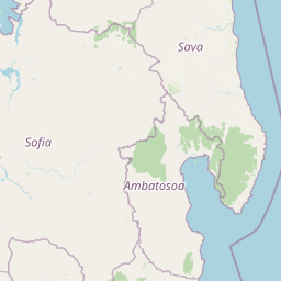
Map view of Tampoketsa Analamaitso Reserve

Use this park location map to pinpoint Tampoketsa Analamaitso Reserve in Madagascar, understand its exact geographic position, and read its mapped placement within the surrounding landscape more clearly.

Pigeon | © OpenStreetMap contributors

Location context for Tampoketsa Analamaitso Reserve

Sofia region
Park atlas

Compare surrounding forest landscapes and regional conservation areas in northern Madagascar.

Other Protected Areas and Parks Near Tampoketsa Analamaitso Reserve

Browse nearby national parks and protected areas connected to the regional geography of Tampoketsa Analamaitso Reserve. Continuing into these adjacent wilderness zones reveals broader patterns across northern Madagascar conservation landscapes.
Wildlife reserveAnalanjirofo
About 102 km away#1 closest

East

Réserve spéciale d'Ambatovaky: Protected Forest Landscape and Wildlife Reserve in Analanjirofo

Mapping rugged terrain and endemic forest ecosystems in northeastern Madagascar.

Réserve spéciale d'Ambatovaky spans a challenging, topographically complex area of northeastern Madagascar. This wildlife reserve consists of an unbroken canopy of humid lowland and hill forests, providing a critical refuge for rare raptors and diverse primate communities within the Analanjirofo region's mountainous terrain.

Area
600.5 km²
Established
1958
IUCN
IV
Relief
Upland
National parkBoeny Region
About 104 km away#2 closest

West

Ankarafantsika National Park: Protected Area Atlas and Regional Geography Discovery

Explore mapped boundaries and natural landscape context.

Ankarafantsika National Park serves as a key protected area for understanding the geography of Madagascar's Boeny Region. This canonical page offers a detailed atlas-style view, highlighting the park's mapped boundaries and its role as a distinct natural landscape. Engage with structured geographic data to comprehend the park's protected status and its contribution to the regional terrain, facilitating a deeper appreciation of protected lands.

Area
1,365.13 km²
Established
2002
IUCN
II
Relief
Lowland
Protected landscapeAlaotra-Mangoro
About 139 km away#3 closest

South

Lake Alaotra Protected Landscape: Atlas and Geographic Wetland Profile

Mapping the primary wetland basin of Madagascar's Alaotra-Mangoro region.

Lake Alaotra serves as a central protected landscape within the Alaotra-Mangoro region, featuring an extensive system of marshes, reedbeds, and freshwater zones. This profile offers a structured look at the lake's geography, its role as a critical wetland habitat, and the surrounding terrain that shapes this important Madagascar catchment area.

Area
7,223 km²
Relief
Lowland
Scope
Terrestrial
Water
Water-dominated
National parkMadagascar
About 161 km away#4 closest

East

Mananara Nord National Park: National Park Geography and Protected Landscape Identity

Explore its mapped boundaries within Madagascar's diverse geography.

Mananara Nord National Park represents a vital protected landscape within Madagascar, offering users a direct entry point for exploring its specific geographic character. As a designated national park, it contributes significantly to the atlas of conservation lands on the island nation. This park provides a focused lens through which to examine regional geography and the mapped extent of protected natural areas, anchoring its identity within the broader context of Madagascar's unique ecological landscape.

National parkMadagascar
About 167 km away#5 closest

Northeast

Makira Natural Park: Exploring the Geography and Forested Terrain of Northeastern Madagascar

A vital protected landscape in the humid northeastern forest belt.

Makira Natural Park serves as a benchmark for integrated tropical conservation in Madagascar. Its humid evergreen forests provide a critical habitat for high lemur diversity and specialized botanical associations linked to unique geological substrates. This protected area connects to a larger regional landscape of community-managed forests, acting as a crucial buffer for the biodiversity of the northeastern coastal regions.

Area
3,724.7 km²
Established
2012
IUCN
II
Relief
Mountain
Nature reserveAlaotra-Mangoro
About 167 km away#6 closest

South

Ankeniheny-Zahamena Corridor: Nature Reserve Landscape and Regional Geography

Mapping the central rainforest belt of the Alaotra-Mangoro region

Spanning over 3,800 square kilometers, the Ankeniheny-Zahamena Corridor stands as a cornerstone of Malagasy conservation. This reserve integrates diverse humid forest habitats into a single functioning landscape, providing a critical haven for endemic flora and threatened primates. Its role as a major watershed catchment reinforces its environmental importance for surrounding communities across eastern and western Madagascar.

Area
3,810 km²
Established
2007
IUCN
VI
Relief
Mixed relief
National parkMadagascar
About 176 km away#7 closest

South

Zahamena National Park: Madagascar National Park Exploration and Geographic Context

Mapping the protected boundaries and landscape of Zahamena National Park.

Delve into Zahamena National Park, a vital protected territory situated in Madagascar. This national park offers a unique perspective on the island's natural geography and its status as a significant protected landscape. Understand its position within Madagascar's broader context, focusing on the mapped aspects of its protected area identity and its contribution to the country's renowned biodiversity hotspot status.

Area
423 km²
Established
1997
IUCN
II
Relief
Mountain
National parkAmbatosoa
About 183 km away#8 closest

Northeast

Nosy Mangabe National Park: Atlas Overview of the Ambatosoa Island Forest Reserve

Coastal rainforests and protected lemur habitats in Antongil Bay.

Nosy Mangabe stands as a prominent protected island within the Ambatosoa region of Madagascar. The island is defined by its dense lowland rainforest, dramatic bay topography, and its essential role as a sanctuary for rare primates. This overview maps the park boundary and explores the terrain, historical maritime traces, and the connection between the island and the Masoala peninsula ecosystem.

Area
90.47 km²
Established
1965
IUCN
II
Visitors
3K annual

Common questions about visiting, size, designation, and location context for Tampoketsa Analamaitso Reserve

Tampoketsa Analamaitso Reserve FAQs for park facts, access, geography, and protected area context

Find quick answers about Tampoketsa Analamaitso Reserve, including protected-area facts, park geography, trail and visitor context, and how the park fits into its surrounding country and regional landscape.
MoriAtlas Explorer

Continue Your Protected Areas Search Across the Global Atlas

Deepen your exploration by continuing the structured search for national parks and protected areas worldwide. Utilize the comprehensive filtering capabilities to compare different conservation landscapes and refine your understanding of global park geography. Discover more about the distribution and characteristics of protected natural areas.

Global natural geography