

Mori Atlas logo
National parkTasman National Park

Explore the mapped park boundaries and regional context of this Australian national park.

Tasman National Park: Your Gateway to Tasmania's Protected Landscape Geography

Tasman National Park stands as a significant protected area within the island state of Tasmania, Australia. This page offers an atlas-focused exploration of its protected landscape, detailing its geographic setting and mapped boundaries. Understand how Tasman National Park contributes to Tasmania's renowned protected land distribution and its role in Australia's broader geographic context.

coastal national parkdolerite cliffsendemic floraimportant bird areaTasman Peninsulacolumnar rock formations

Tasman National Park

National park

Park overview

Structured park overview, official facts, and landscape profile for Tasman National Park

Tasman National Park park facts, protected area profile, and essential visitor context
Review the core facts for Tasman National Park, including designation, size, terrain, visitor scale, habitats, and operating context in one park-focused overview.

About Tasman National Park

Tasman National Park occupies a dramatic position on Tasmania's southeastern coastline, where the forces of the Southern Ocean have sculpted one of Australia's most geologically significant coastal landscapes. The park encompasses both the Forestier and Tasman Peninsulas, together with Tasman Island, creating a protected corridor that preserves the region's wild coastal character. The dolerite formations that define the park's identity represent a rare rock type on mainland Australia, with the columnar structures at Cape Pillar forming the centerpiece of the park's geological significance. These ancient Jurassic dolerite sills have been exposed through millions of years of erosion, revealing spectacular hexagonal columns that rise in towering cliffs above the Tasman Sea. The park's establishment in 1999 marked the culmination of regional conservation efforts under Tasmania's Regional Forest Agreement, formalizing protection for landscapes that had long been valued for their natural and cultural heritage. Beyond its geological wonders, the park provides critical habitat for several endemic plant species and serves as an important bird area recognized internationally for the conservation of endangered woodland birds.

Quick facts and research context for Tasman National Park

Tasman National Park lies approximately 56 kilometers east of Hobart on Tasmania's southeastern coast, encompassing parts of both the Forestier and Tasman Peninsulas as well as Tasman Island. The park was formally proclaimed under the Regional Forest Agreement on 30 April 1999 and is managed by the Tasmania Parks and Wildlife Service. It covers 107.5 square kilometers and holds IUCN Category II protected area status. The park contains the highest dolerite sea cliffs in the world at Cape Pillar, where columnar rock formations rise dramatically from the Southern Ocean.

Park context

Deeper park guide and search-rich context for Tasman National Park

Tasman National Park history, landscape, wildlife, and travel context
Explore Tasman National Park through its history, landscape character, ecosystems, wildlife, conservation priorities, cultural context, and seasonal travel timing in a structured park guide built for atlas discovery and search intent.

Why Tasman National Park stands out

Tasman National Park is best known for its extraordinary dolerite cliff formations. The columnar joints at Cape Pillar and Tasman Island create sheer walls rising 300 meters above sea level, ranking among the highest sea cliffs globally. The park protects three endemic Euphrasia species and the rare Cape Pillar Sheoak, a shrub found only within the park's boundaries. The dramatic coastal geology features natural arches, sea caves, and rock stacks including Tasmans Arch, Cathedral Rock, and the Totem Pole. The Three Capes Track, a 46-kilometer multi-day hiking route opened in 2015, traverses the park's most spectacular coastal terrain.

Tasman National Park history and protected-area timeline

European interest in the Tasman Peninsula dates to the early nineteenth century, with whaling operations active in the 1830s and 1840s along the park's coastlines. The area's strategic significance led to military installations during the colonial period, and the dramatic dolerite cliffs at Cape Raoul bear scars from Royal Navy gunnery practice by warships of the Australia Station during the late 1800s. Tasman Island received a lighthouse in 1906, built to guide vessels through the hazardous waters of the southern coast; the lighthouse and accompanying weather station became unmanned in 1977 and now stand as historical features within the park. Formal protection came relatively late, with the park proclaimed under the Regional Forest Agreement on 30 April 1999, recognizing both the geological significance and ecological value of the peninsula's remaining natural landscapes. The development of the Three Capes Track in the early 2010s represented a significant investment in park infrastructure, with the 46-kilometer route opening in December 2015 after decades of advocacy by the Hobart Walkers Club, whose members first proposed the track in the 1960s.

Tasman National Park landscape and geographic character

The landscape of Tasman National Park is dominated by the dramatic presence of Jurassic dolerite, an igneous rock intrusion that forms the backbone of the Tasman and Forestier Peninsulas. At Cape Pillar and Tasman Island, this dolerite weathers into spectacular columnar formations creating cliffs that reach 300 meters above sea level, among the highest in the world. The coastline features a succession of sea caves, blowholes, and natural arches formed by wave action, including Tasmans Arch, a dramatic limestone formation extending from the cliff face, and Devils Kitchen, a collapsed sea cave. The park's interior features rolling terrain with exposed granite and dolerite peaks, transitioning from coastal heath and scrubland at lower elevations to wet sclerophyll forest in the valleys and subalpine vegetation on the higher ground. The Lanterns, three small islands off the coast, add to the coastal diversity, while the Totem Pole, Cathedral Rock, and Candlestick represent iconic sea stacks that punctuate the marine horizon.

Tasman National Park ecosystems, habitats, and plant life

The vegetation of Tasman National Park reflects the park's position in the cool temperate climate zone of southeastern Tasmania. Coastal heath dominates the exposed cliff tops and headlands, characterized by diverse shrubs including Banksia, Epacris, and Leptospermum species. The wet sclerophyll forests in the deeper valleys support tall eucalyptus trees, while the park's significance is amplified by the presence of endemic plant species found nowhere else. Three species of Euphrasia, a semi-parasitic herbaceous plant commonly known as eyebright, occur exclusively within the park's boundaries. The Cape Pillar Sheoak, a distinctive shrub or small tree, is restricted to the Cape Pillar area and Tasman Island, representing a narrow endemic of significant conservation concern. Marine ecosystems around the park's coastline support giant kelp forests, though these face threats from climate change with local extinction recorded at Eaglehawk Neck since 2016.

Tasman National Park wildlife and species highlights

The marine and coastal environments of Tasman National Park support diverse wildlife populations. Australian fur seals breed and rest along the coastline, utilizing the rocky shores and islands for haul-out sites. Little penguins, the world's smallest penguin species, nest along the foreshore areas, with colonies established in coastal crevices and vegetation zones above the beach. The park forms a core component of the South-east Tasmania Important Bird Area, recognized by BirdLife International for its significance in conserving woodland bird communities. The endangered swift parrot, a species endemic to southeastern Australia and Tasmania, inhabits the park's forested areas, as does the forty-spotted pardalote, one of Australia's rarest birds, found primarily in Tasmania's dry sclerophyll forests. These bird species depend on the park's mixed vegetation communities for foraging and nesting habitat.

Tasman National Park conservation status and protection priorities

Tasman National Park plays a critical role in protecting Tasmania's southeastern coastal ecosystems and geological heritage. The park's designation as an IUCN Category II protected area recognizes its significance as a national park managing landscape-scale conservation. The protection of endemic plant species, particularly the three Euphrasia species and Cape Pillar Sheoak, represents a key conservation priority given their extremely restricted distributions. The Important Bird Area designation underscores the park's international significance for threatened bird species, particularly the swift parrot and forty-spotted pardalote. Climate change poses emerging challenges, with warming waters already causing the local extinction of giant kelp forests and raising concerns about the long-term viability of cool temperate species adapted to the current climate regime.

Tasman National Park cultural meaning and human context

The Tasman Peninsula has a rich human history that predates formal protected area status. Aboriginal communities have connections to this landscape over thousands of years, though documented historical accounts focus primarily on the colonial period. The dramatic coastline served as a resource for early colonial industries, with whaling operations in the mid-nineteenth century exploiting the marine resources of the coastal waters. The establishment of the Port Arthur penal settlement on the adjacent peninsula in the 1830s brought increased human activity to the region, though the steeper, more rugged terrain of what is now Tasman National Park remained relatively isolated. The Tasman Island Lighthouse represents the most visible historical infrastructure within the park, a reminder of the maritime significance of this treacherous coastline.

Top sights and standout views in Tasman National Park

Tasman National Park offers some of Tasmania's most dramatic coastal scenery, centered on the towering dolerite cliffs of Cape Pillar and the remarkable columnar rock formations that define the landscape. The Three Capes Track provides immersive access to this terrain, allowing hikers to traverse from Port Arthur to Fortescue Bay through the park's most spectacular environments. Geological features including Tasmans Arch, Devils Kitchen, and the succession of sea stacks along the coast showcase the ongoing processes shaping this landscape. The park's endemic plant species, particularly the Cape Pillar Sheoak and the three Euphrasia species, represent botanical treasures found nowhere else on Earth. Coastal wildlife viewing opportunities include Australian fur seals hauled out on rocky shores and little penguin colonies nesting in the foreshore areas.

Best time to visit Tasman National Park

The cool temperate climate of Tasmania's southeastern coast offers distinct seasonal experiences for visitors to Tasman National Park. Summer months from December through February bring the warmest conditions and longest daylight hours, making this the most popular time for hiking the Three Capes Track and exploring the coastal features. Autumn and spring offer milder conditions with fewer visitors, though weather can be more variable with increased rainfall. Winter brings cold temperatures and shorter days, but the dramatic storm-washed coastline takes on a particularly powerful character during this season. The park is accessible year-round, though trail conditions and visibility vary with the seasons.
Park location guide

Geography guide, regional context, and park location map for Tasman National Park

Tasman National Park park geography, regions, and map view in Australia
Understand where Tasman National Park sits in Australia through a broader geographic reading of the surrounding landscape, nearby location context, and its mapped position within the national park landscape.

How Tasman National Park fits into Australia

Australia is a constitutional monarchy and federal parliamentary democracy comprising six states and ten territories. With a population of nearly 28 million, it is one of the world's most urbanised countries, with most people concentrated on the eastern seaboard. The country has a high Human Development Index and is known for its cultural diversity, ancient Aboriginal heritage, and unique wildlife.

Wider geography shaping Tasman National Park in Australia

Australia occupies the entire Australian continent, the island of Tasmania, and numerous smaller islands. It is the world's flattest and driest inhabited continent, featuring vast deserts in the interior (the Outback), tropical rainforests along the eastern coast, and a coastline bordering the Indian and Pacific Oceans.

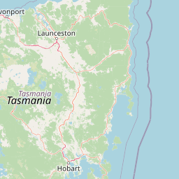
Map view of Tasman National Park

Use this park location map to pinpoint Tasman National Park in Australia, understand its exact geographic position, and read its mapped placement within the surrounding landscape more clearly.

Pigeon | © OpenStreetMap contributors

Location context for Tasman National Park

Tasmania
Park atlas

Compare diverse protected landscapes and trace the regional park geography surrounding Tasman National Park, Tasmania.

Discover Related National Parks and Protected Areas Near Tasman National Park, Tasmania
Explore additional national parks and protected areas located in the wider geographic context of Tasman National Park, featuring distinct coastal landforms and diverse conservation landscapes. This atlas view allows for comparing various protected areas across the region, highlighting their unique geological features, coastal ecosystems, and forest environments.
National parkTasmania

Freycinet National Park: Iconic Granite Peaks and Protected Coastal Landscape in Tasmania

Mapped geography and distinct terrain of Tasmania's historic national park.

Freycinet National Park on Tasmania's east coast is a remarkable protected landscape defined by its dramatic granite mountains, including The Hazards, and the pristine Wineglass Bay. Established as one of Tasmania's first national parks, it showcases unique geological formations and coastal ecosystems across its rugged terrain. This detailed view provides an atlas-style exploration of its mapped boundaries and geographic significance within the regional context.

Area
169 km²
Established
1916
IUCN
II
Visitors
200K annual
National parkTasmania

Hartz Mountains National Park: Tasmania's National Park Protected Landscape

Mapped geography and regional landscape context.

Delve into the specific protected landscape identity of Hartz Mountains National Park, situated in Tasmania, Australia. This page provides a detailed geographic breakdown, focusing on mapped park boundaries and its unique regional setting. Understand the atlas value of this national park by exploring its terrain and its role within Tasmania's broader conservation landscape.

Area
71.4 km²
Established
1939
IUCN
II
Visitors
11.8K annual
National parkTasmania

Mount Field National Park: Explore Tasmania's Protected Landscape and Geographic Identity

Mapped terrain and regional atlas context for this Australian national park.

Mount Field National Park serves as a cornerstone of protected natural landscapes in Tasmania, Australia. This entry provides detailed geographic context, focusing on its mapped boundaries and distinct environmental setting. Users can explore its identity as a national park, understand its regional placement within Tasmania, and gain insight into the mapped terrain that defines this significant protected area. It is designed for atlas-based discovery of the park's landscape characteristics.

Area
162.65 km²
Established
1916
IUCN
II
Relief
Mountain
Watercolor illustration of a landscape featuring hills, trees, and a winding river
National parkTasmania

Douglas-Apsley National Park: Discover its Protected Landscape and Geographic Context in Tasmania

Mapped boundaries and regional terrain of a key Tasmanian national park.

Delve into the geographic details of Douglas-Apsley National Park, a designated national park situated in Tasmania, Australia. This entry provides insight into the park's protected landscape identity, its mapped boundaries, and its contribution to the rich regional geography of Tasmania. Understanding its place within the island's natural terrain is crucial for comprehensive atlas-driven exploration and appreciating Australia's protected areas.

Area
160.8 km²
Established
1989
IUCN
II
Relief
Upland
National parkTasmania

Southwest National Park: Tasmania's Core Wilderness National Park and World Heritage Landscape

Mapping the remote buttongrass moorlands and rugged terrain of this expansive park.

Southwest National Park represents a significant protected area in Tasmania, Australia, spanning over 6,183 square kilometers. As the heart of the Tasmanian Wilderness World Heritage Area, it showcases an extraordinary landscape characterized by vast buttongrass moorlands, ancient temperate rainforests, and dramatic mountainous terrain. This park is vital for its wilderness character and conservation significance, offering a unique opportunity to explore one of the Southern Hemisphere's last remaining untouched temperate wildernesses through its mapped geography and protected boundaries.

Area
6,182.67 km²
Established
1968
IUCN
II
Relief
Mountain
National parkTasmania

Walls of Jerusalem National Park: A Mapped Alpine Wilderness in Tasmania

Explore protected landscapes with biblical place names.

Walls of Jerusalem National Park in Tasmania is a distinguished national park characterized by its rugged alpine terrain and dramatic quartzite formations, most notably King Davids Peak. The park's landscape is further distinguished by a unique series of features named after biblical locations, offering an evocative exploration for those interested in geographic discovery. As a protected wilderness area within the Tasmanian Wilderness World Heritage Area, it provides valuable insight into Australia's significant natural landscapes and their mapped representation.

Area
518 km²
Established
1978
IUCN
II
Relief
Mountain
National parkTasmania

Mole Creek Karst National Park: Mapped Protected Area and Tasmanian Landscape Atlas

Explore the geography and park boundaries within Tasmania's protected lands.

Mole Creek Karst National Park stands as a key protected area within Tasmania, offering a unique glimpse into the island state's natural geography. This resource facilitates an atlas-style discovery of the park's mapped landscape, its protected boundaries, and its significance within the broader context of Australian protected lands. Understand the park's terrain and its role in the region's conservation heritage.

Area
13.45 km²
Established
1996
IUCN
II
Relief
Mountain
National parkTasmania

Cradle Mountain, Lake St Clair National Park: Tasmania's Mapped Protected Landscape and Geography

Explore national park boundaries and regional natural terrain.

Gain insight into Cradle Mountain, Lake St Clair National Park, a protected national park in Tasmania, Australia. This entry provides a foundational understanding of its mapped terrain, geographic setting, and protected area status. Delve into the specific landscape characteristics that define this significant conservation zone and its place within the national atlas.

Area
1,614.43 km²
Established
1922
IUCN
II
Visitors
209K annual

Common questions about visiting, size, designation, and location context for Tasman National Park

Tasman National Park FAQs for park facts, access, geography, and protected area context
Find quick answers about Tasman National Park, including protected-area facts, park geography, trail and visitor context, and how the park fits into its surrounding country and regional landscape.
MoriAtlas Explorer

Continue Your Protected Areas Search Across the Global Atlas

Deepen your exploration by continuing the structured search for national parks and protected areas worldwide. Utilize the comprehensive filtering capabilities to compare different conservation landscapes and refine your understanding of global park geography. Discover more about the distribution and characteristics of protected natural areas.

Global natural geography