

Mori Atlas logo
Marine protected areaThunder Bay National Marine Sanctuary and Underwater Preserve

Discover the underwater cultural significance and glacial coastal geography of this Lake Huron protected area.

Thunder Bay National Marine Sanctuary and Underwater Preserve: Mapping Maritime Heritage and Freshwater Landscapes

Thunder Bay National Marine Sanctuary and Underwater Preserve protects a concentration of historic shipwrecks within the cold, clear waters of Lake Huron near Alpena, Michigan. This unique protected landscape features a complex interaction between glacial coastal geology, shallow rocky reefs, and productive freshwater wetlands. The region serves as a significant site for maritime archaeological history and diverse aquatic habitats where terrestrial and lacustrine environments meet.

national marine sanctuarygreat lakeslake huronshipwrecksunderwater archaeologyfreshwater diving

Thunder Bay National Marine Sanctuary and Underwater Preserve

Marine protected area

Park overview

Structured park overview, official facts, and landscape profile for Thunder Bay National Marine Sanctuary and Underwater Preserve

Thunder Bay National Marine Sanctuary and Underwater Preserve park facts, protected area profile, and essential visitor context

Review the core facts for Thunder Bay National Marine Sanctuary and Underwater Preserve, including designation, size, terrain, visitor scale, habitats, and operating context in one park-focused overview.

About Thunder Bay National Marine Sanctuary and Underwater Preserve

Thunder Bay National Marine Sanctuary and Underwater Preserve occupies a distinctive stretch of Lake Huron's western shoreline in northeastern Lower Michigan, centered on the natural harbor historically known as Thunder Bay near the city of Alpena. The bay's name refers to the thunderous sound that the Indigenous people of the region reportedly associated with waves striking the rocky coast. The site's cultural and ecological value has accumulated over thousands of years of human interaction with the lake, from Indigenous travel and fishing routes to the booming era of commercial shipping that defined the Great Lakes in the nineteenth and twentieth centuries.

Designated as a National Marine Sanctuary in 2000, the site became the first freshwater sanctuary in the United States sanctuary system, marking an important expansion of federal ocean and Great Lakes protection beyond purely marine saltwater environments. In 2005, Michigan established the adjacent Thunder Bay Underwater Preserve under state jurisdiction, combining federal and state authorities to protect both the submerged cultural resources and the surrounding waters as a single integrated heritage zone. The joint sanctuary and preserve arrangement is considered a model for cooperative management between federal, state, tribal, and local partners.

The protected waters draw divers, snorkelers, maritime historians, and naturalists from across the United States and beyond. Wrecks range from small nineteenth-century schooners to massive steel freighters, and they lie at depths that make them accessible to recreational divers using standard certification. In addition to the wrecks themselves, the sanctuary preserves the storytelling, archaeology, and conservation practices that keep this heritage alive.

Alongside its cultural resources, the sanctuary encompasses a biologically rich freshwater coastal environment. The shoreline features rocky limestone reefs, drowned river mouths, coastal marshes, cobble beaches, and forested uplands. These nearshore habitats support diverse populations of fish, migratory waterfowl, and other wildlife, tying the maritime archaeology mission of the sanctuary to broader Great Lakes ecological concerns, including water quality, invasive species, and coastal resilience.

Quick facts and research context for Thunder Bay National Marine Sanctuary and Underwater Preserve

Thunder Bay National Marine Sanctuary is the only National Marine Sanctuary located in the Great Lakes. It is administered by the National Oceanic and Atmospheric Administration in partnership with the State of Michigan and local stakeholders. The sanctuary and adjacent Underwater Preserve together extend along a substantial stretch of northeastern Lower Michigan Lake Huron shoreline in and around Alpena County. The protected area is widely regarded as a premier cold-water freshwater diving destination and a leading center for Great Lakes maritime archaeology and research.

Protection and recognition

Documented protection history, marine scope, and official designation details

Thunder Bay National Marine Sanctuary and Underwater Preserve Protection Status

Marine protection status for Thunder Bay National Marine Sanctuary and Underwater Preserve establishes the foundational conservation framework and designated establishment year. Documented management parameters provide clear factual tracking for this protected marine landscape and governing scope.

Protection details

Protection scope
Marine
Designated year
2014
Transboundary protection
No
Park context

Deeper park guide and search-rich context for Thunder Bay National Marine Sanctuary and Underwater Preserve

Thunder Bay National Marine Sanctuary and Underwater Preserve history, landscape, wildlife, and travel context

Explore Thunder Bay National Marine Sanctuary and Underwater Preserve through its history, landscape character, ecosystems, wildlife, conservation priorities, cultural context, and seasonal travel timing in a structured park guide built for atlas discovery and search intent.

Why Thunder Bay National Marine Sanctuary and Underwater Preserve stands out

Thunder Bay is best known for its extraordinary density of historic shipwrecks preserved in cold, clear Lake Huron waters, making the site a globally significant freshwater maritime heritage area. The sanctuary encompasses a remarkable cross-section of Great Lakes shipping history, with wooden schooners, early steamers, steel bulk carriers, and even unique vessel types resting side by side within a relatively compact section of coastline. It is also recognized as a laboratory for underwater archaeology, where researchers, professional archaeologists, and volunteer divers work together to document, monitor, and interpret submerged cultural resources. The combination of archaeological research, public access, and educational programming has given the sanctuary an outsized reputation well beyond its physical size.

Thunder Bay National Marine Sanctuary and Underwater Preserve history and protected-area timeline

The cultural history of the Thunder Bay area stretches back long before European exploration, with the bay and surrounding Lake Huron coastline forming part of the traditional territories of Indigenous peoples who traveled, fished, and traded across the Great Lakes. In the nineteenth century the region became a focal point of Great Lakes commercial shipping, as ports like Alpena grew around the lumber trade, cement and limestone quarrying, and the movement of bulk cargo across the upper Midwest.

Shipwrecks accumulated in Thunder Bay for a combination of reasons: the bay's position as a busy harbor of refuge, sudden Lake Huron storms, heavy seasonal shipping traffic, the prevalence of fragile wooden vessels, and collisions between inbound and outbound vessels. Over time the bay gained a reputation as a graveyard of ships, ultimately preserving a layered chronological record of Great Lakes maritime technology.

Modern protection began with growing public and scholarly concern about the fragility of these underwater resources, particularly as sport diving expanded and artifacts became more vulnerable to disturbance. Advocacy by divers, historians, archaeologists, and Michigan residents led to the site being formally studied for federal protection. In 2000, the U.S. Congress designated Thunder Bay as a National Marine Sanctuary, and in subsequent years management efforts built partnerships with the State of Michigan, tribal nations, local governments, recreational diving organizations, and academic institutions.

The sanctuary's boundary was later expanded, and in 2005 the Thunder Bay Underwater Preserve was designated by the State of Michigan to provide complementary protection and to extend managed access for divers. Together, federal, state, and local collaboration have produced a continuously evolving program of survey, mapping, interpretation, and stewardship that has reshaped public understanding of Great Lakes underwater heritage.

Thunder Bay National Marine Sanctuary and Underwater Preserve landscape and geographic character

The landscape of the Thunder Bay sanctuary is defined by Lake Huron's freshwater coastline, where glacial history meets modern lake dynamics. The shoreline alternates between limestone bedrock cliffs, cobble beaches, sand spits, low wetlands, and small fringing islands. The bay itself is a broad indentation along an otherwise relatively straight stretch of coast, offering natural shelter that drew shipping traffic and later shipwrecks.

Beneath the surface, the underwater terrain is shaped largely by the same processes that shaped the land. The bottom includes rocky reefs, sloping clay banks, sand flats, and shallow shoals interspersed with deeper channels. These varied substrates influence where ships came to rest and where aquatic life congregates today.

Onshore and nearshore habitats include coastal marshes, stream mouths, drowned river mouths, and vegetated uplands. Together these environments form a transitional zone between terrestrial northern Michigan ecosystems and Lake Huron's open-water ecosystem, supporting both terrestrial and aquatic species at the boundary between land and lake.

Thunder Bay National Marine Sanctuary and Underwater Preserve ecosystems, habitats, and plant life

The ecological identity of the sanctuary is firmly rooted in Lake Huron's cold freshwater ecosystem. Like much of the Great Lakes, the bay's waters are cool, well-oxygenated, and relatively clear in many areas, creating conditions that support a diverse community of fish, invertebrates, aquatic plants, and microbes. The clarity of local waters is part of what makes the shipwrecks so visually remarkable and the sanctuary so important for divers.

Nearshore habitats range from exposed rocky shores and reefs, where wave-tolerant algae, invertebrates, and small fish dominate, to quieter bays and river mouths where submerged aquatic vegetation, sedges, and emergent wetland plants flourish. These varied habitats support whitefish, walleye, lake trout, perch, smallmouth bass, and numerous forage fish species, as well as the invertebrates that anchor the food web.

Coastal wetlands around the sanctuary act as nurseries, migration corridors, and refuges for amphibians, waterfowl, and mammals. Seasonal blooms and shifts in water temperature create a dynamic ecological rhythm, with cold winters, productive springs, warm summers, and biologically active autumns marking the cycles of the lake.

Thunder Bay National Marine Sanctuary and Underwater Preserve wildlife and species highlights

Thunder Bay's wildlife reflects the broader biodiversity of the northern Lake Huron region. Underwater, fish communities include both native Great Lakes species and those influenced by historic stocking, stocking changes, and management. Bald eagles, ospreys, and various waterfowl species are commonly associated with the shoreline, while mammals such as white-tailed deer and smaller forest and wetland mammals use the surrounding lands.

The sanctuary's mix of coastal habitats creates productive stopover points for migratory birds, particularly during spring and autumn. Amphibians and reptiles use adjacent wetlands and forested uplands, while aquatic invertebrates contribute to the lake's food web and form an important link between habitats.

Although the sanctuary is most famous for its wrecks rather than its wildlife, the connection between healthy freshwater ecosystems and well-preserved underwater cultural resources is fundamental to its identity and an increasingly important part of its management focus.

Thunder Bay National Marine Sanctuary and Underwater Preserve conservation status and protection priorities

From a conservation perspective, Thunder Bay represents a rare alignment of cultural and natural resource protection within a single Great Lakes site. Its primary conservation mission is the stewardship of submerged cultural resources: shipwrecks, their associated artifacts, and the historical context they represent. This mission addresses challenges such as anchor damage, looting, sediment disturbance, water-quality changes, and the slow but real effects of time on fragile wooden and metal structures.

Equally important is the conservation of the surrounding freshwater ecosystem. Managers and partners monitor water quality, aquatic invasive species, coastal development, and shoreline erosion, all of which can affect both ecological conditions and the long-term preservation of shipwrecks. Wetland habitats along the coast are protected as part of broader ecological health, recognizing the role they play in lake biodiversity.

The sanctuary is also a leader in public education and citizen-science engagement, training volunteer divers in archaeological monitoring and engaging students and visitors in Great Lakes science. This combination of research, protection, and public engagement is central to its conservation model, with the goal of ensuring that the shipwrecks and surrounding freshwater ecosystem remain accessible and meaningful for future generations.

Thunder Bay National Marine Sanctuary and Underwater Preserve cultural meaning and human context

Thunder Bay carries layered cultural meaning. For Indigenous peoples, the area long predates any European designation, with the bay and surrounding waters forming part of historic travel, trade, and ceremonial landscapes of the Great Lakes. Respectful engagement with tribal nations is part of the sanctuary's ongoing work.

In more recent centuries, the bay became a storied chapter of Great Lakes maritime culture, with its wrecks representing the working lives of sailors, captains, merchants, shipbuilders, and the families whose livelihoods depended on shipping. Local communities around Alpena and the northeastern Lower Michigan coast preserve this heritage through museums, festivals, and diver traditions.

The sanctuary has also become a cultural touchstone for sport diving and underwater archaeology, drawing diving clubs, maritime historians, filmmakers, and educators. In this sense, Thunder Bay is not just a collection of wrecks but a living cultural landscape where maritime memory, community pride, scientific inquiry, and outdoor recreation meet.

Top sights and standout views in Thunder Bay National Marine Sanctuary and Underwater Preserve

Globally notable concentration of shipwrecks in cold, clear, shallow Lake Huron waters, with wrecks spanning nearly two centuries of Great Lakes maritime history.

The first and, for many years, the only freshwater National Marine Sanctuary in the United States, jointly managed with Michigan's Thunder Bay Underwater Preserve.

A premier cold-water freshwater diving destination where many wrecks lie within recreational diving depths.

A hub for Great Lakes underwater archaeology, public education, and citizen-science diving programs, supported by strong partnerships with state, tribal, academic, and local stakeholders.

A biologically rich nearshore environment where coastal wetlands, river mouths, rocky reefs, and open-lake waters support diverse freshwater wildlife.

Best time to visit Thunder Bay National Marine Sanctuary and Underwater Preserve

Late spring through early autumn is generally the most comfortable window for shoreline and above-water visits, with mild air temperatures, longer daylight, and more predictable conditions for boating, diving, and outdoor learning. Summer offers the warmest water temperatures for recreational diving and the liveliest visitor programming, though visibility varies with weather and lake conditions.

For divers, the shoulder seasons can also be rewarding, when cooler temperatures and stable weather may yield excellent underwater visibility. Wildlife observers may find spring and autumn particularly appealing for migratory birds and seasonal changes in the coastal landscape. Winter brings frozen or stormy conditions that limit access but shapes the lake's annual ecological rhythm that managers must consider year-round.

Monthly climate preview

Long term temperature and precipitation patterns across representative coordinates

Thunder Bay National Marine Sanctuary and Underwater Preserve Climate Normals

Representative coordinates record measured monthly temperature swings from negative lows to warm summer highs alongside steady precipitation throughout the year. Reviewing twelve month averages provides a structured baseline for understanding long term environmental conditions at Thunder Bay National Marine Sanctuary and Underwater Preserve.
Annual mean7 °C
-4 °C20 °C
Jan-4°
Feb-4°
Mar-1°
Apr
May
Jun13°
Jul18°
Aug20°
Sep16°
Oct10°
Nov
Dec
Warmest month
August

19.5 °C

Coolest month
February

-4.1 °C

Wettest month
August

2.5 mm/day

Driest month
February

1.3 mm/day

Park location guide

Geography guide, regional context, and park location map for Thunder Bay National Marine Sanctuary and Underwater Preserve

Thunder Bay National Marine Sanctuary and Underwater Preserve park geography, regions, and map view in United States of America

Understand where Thunder Bay National Marine Sanctuary and Underwater Preserve sits in United States of America through a broader geographic reading of the surrounding landscape, nearby location context, and its mapped position within the national park landscape.

How Thunder Bay National Marine Sanctuary and Underwater Preserve fits into United States of America

The United States of America is a federal presidential republic and one of the world's largest countries by area and population. It consists of 50 states across a vast territory spanning multiple time zones, with its capital in Washington, D.C. and largest city in New York City. The nation has a diverse economy, influential political system, and significant cultural and military presence globally.

Wider geography shaping Thunder Bay National Marine Sanctuary and Underwater Preserve in United States of America

The United States occupies a vast territory in North America, bordered by Canada to the north and Mexico to the south. The 48 contiguous states stretch from the Atlantic to the Pacific Ocean, while Alaska occupies the northwestern region and Hawaii is an archipelago in the Pacific. The country encompasses diverse terrain including the Rocky Mountains, Appalachian Mountains, Great Plains, and extensive river systems.

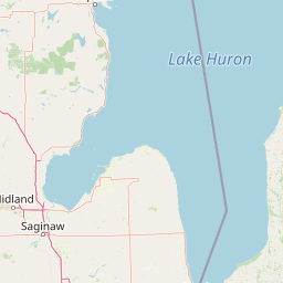
Map view of Thunder Bay National Marine Sanctuary and Underwater Preserve

Use this park location map to pinpoint Thunder Bay National Marine Sanctuary and Underwater Preserve in United States of America, understand its exact geographic position, and read its mapped placement within the surrounding landscape more clearly.

Pigeon | © OpenStreetMap contributors

Location context for Thunder Bay National Marine Sanctuary and Underwater Preserve

Michigan
Park atlas

Compare regional protected areas and connected freshwater landscapes

Explore Other Parks Near Thunder Bay National Marine Sanctuary and Underwater Preserve

Browse nearby national parks and related protected areas to examine regional freshwater ecosystems and maritime heritage sites. Broaden your geographic comparison by discovering surrounding conservation landscapes that share similar glacial histories.
Marine protected areaMichigan
Mapped location lies within the park boundary#1 closest

Thunder Bay National Marine Sanctuary: Geography and Protected Maritime Landscape Context

Mapping underwater heritage in the Michigan Great Lakes region

Spanning 4,300 square miles of Lake Huron, Thunder Bay National Marine Sanctuary preserves a significant collection of shipwrecks within a glacially shaped freshwater terrain. This marine protected area offers a look at submerged geography ranging from shallow coastal bays to deep lake basins. It serves as a vital anchor for understanding maritime history and freshwater ecosystem stability across the Michigan shoreline.

Area
11,000 km²
Established
2000
Relief
Lowland
Climate
Temperate
Protected landscapeMichigan
About 76 km away#2 closest

Southwest

Huron, Manistee National Forests: Geography, Protected Land, and Michigan Landscape Atlas

Exploration of glacial terrain, river basins, and coastal wilderness.

The Huron, Manistee National Forests stand as a significant protected landscape in northern Michigan, featuring a vast network of inland rivers and lakes. This atlas entry provides geographic context on its glacial geology, the rare dune ecosystems along Lake Michigan, and the distribution of pine-dominated forest habitats across the two administrative units.

Area
3,960 km²
IUCN
VI
Relief
Lowland
Climate
Temperate
National parkOntario
About 130 km away#3 closest

East

Bruce Peninsula National Park: National Park Protected Landscape and Geographic Context in Ontario

Discover its mapped boundaries and regional landscape identity.

Bruce Peninsula National Park stands as a protected national park entity within Ontario, offering a distinct geographic profile. Its mapped boundaries and position within the regional atlas are crucial for understanding its landscape character. MoriAtlas facilitates exploration of the park's protected status and its contribution to the conservation landscape of Ontario.

Area
154 km²
Established
1987
IUCN
II
Visitors
460.4K annual
Protected landscapeUpper Peninsula of Michigan
About 133 km away#4 closest

Northwest

Hiawatha National Forest: Geographic Overview and Protected Area Map of the Upper Peninsula

Coastal forest landscape and wilderness river corridors.

Hiawatha National Forest spans significant portions of the Upper Peninsula of Michigan, bridging the gap between northern hardwood forests and the boreal environments of the Great Lakes. This protected landscape encompasses extensive shorelines along Lake Superior, Lake Michigan, and Lake Huron, alongside six wilderness areas and five designated wild and scenic rivers.

Area
3,621.27 km²
Established
1931
IUCN
VI
Relief
Lowland
Wildlife reserveUnited States of America
About 140 km away#5 closest

Northwest

Round Island Wilderness: Geographic Overview of the Straits of Mackinac Wildlife Reserve

Coastal marsh, conifer forest, and hardwood interior terrain

Round Island Wilderness encompasses nearly all of a 378-acre island sanctuary, distinguished by its mature beech-maple hardwood interior and boreal-leaning conifer forests. This protected land remains an essential study of Great Lakes island ecology, standing as a quiet, undisturbed wilderness edge along the transit routes of the Michigan straits.

Area
1.53 km²
Relief
Lowland
Climate
Temperate
Access
Remote access
Wildlife reserveMichigan
About 155 km away#6 closest

Northwest

Horseshoe Bay Wilderness: A Detailed Geographic Overview of Michigan Protected Lands

Protected wetland habitat and Lake Huron coastal geography

Horseshoe Bay Wilderness represents a pristine 3,787-acre protected area located along the northwestern corner of Lake Huron in Michigan. Administered as part of the Hiawatha National Forest, this wilderness features an intricate post-glacial landscape of riparian wetlands, dense northern whitecedar stands, and quiet shallow waters that serve as vital spawning ground for local aquatic life.

Area
15.33 km²
Established
1987
IUCN
Ib
Relief
Lowland
Wildlife reserveMichigan
About 167 km away#7 closest

Northwest

Mackinac Wilderness Protected Area: Glacial Terrain and River Geography in Upper Michigan

A roadless wilderness reserve within Hiawatha National Forest

Uncover the geographic significance of Mackinac Wilderness, an IUCN Category Ib protected area in Michigan. The unit provides a distinct look at northern forest recovery through a terrain of sandy ridges, aspen and birch cover, and aquatic corridors. This study examines the interplay between postglacial landforms and the ongoing natural succession occurring along the Carp River drainage basin.

Area
49.5 km²
IUCN
Ib
Relief
Lowland
Climate
Temperate
National parkMichigan
About 201 km away#8 closest

West

Sleeping Bear Dunes National Lakeshore: Atlas, Maps, and Protected Landscape Geography

Great Lakes freshwater coast and glacial dune systems

Sleeping Bear Dunes National Lakeshore showcases the unique intersection of glacial geology and freshwater ecology. This protected area features massive dunes resting on ancient glacial deposits, backed by beech and maple forests. The geographic scope includes the vast shoreline of Lake Michigan, inland waters such as Glen Lake, and the distinct maritime history found across the remote North and South Manitou Islands.

Area
288.13 km²
Established
1970
IUCN
III
Visitors
1.5M annual

Common questions about visiting, size, designation, and location context for Thunder Bay National Marine Sanctuary and Underwater Preserve

Thunder Bay National Marine Sanctuary and Underwater Preserve FAQs for park facts, access, geography, and protected area context

Find quick answers about Thunder Bay National Marine Sanctuary and Underwater Preserve, including protected-area facts, park geography, trail and visitor context, and how the park fits into its surrounding country and regional landscape.
MoriAtlas Explorer

Continue Your Protected Areas Search Across the Global Atlas

Deepen your exploration by continuing the structured search for national parks and protected areas worldwide. Utilize the comprehensive filtering capabilities to compare different conservation landscapes and refine your understanding of global park geography. Discover more about the distribution and characteristics of protected natural areas.

Global natural geography