Bays
Lincoln Bay
177 m

Examining the physical landscape, environmental classifications, and marine boundaries
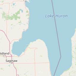
This geographic profile details the environmental and spatial scope of Thunder Bay National Marine Sanctuary. Explore the mapped boundaries, dominant lake and coastal features, and the regional context within Michigan. The dataset includes structured classifications for lacustrine, riverine, and marine habitats across the sanctuary area.
Related tags
A Great Lakes underwater preserve protecting a remarkable cluster of historic shipwrecks in Lake Huron.
Thunder Bay National Marine Sanctuary and Underwater Preserve is a federally protected aquatic area located in Lake Huron off the northeastern coast of Michigan in the United States. Encompassing roughly 4,300 square miles of cold freshwater, the sanctuary is best known for the extraordinary density of historic shipwrecks resting on its bed, a collection that spans nearly two centuries of Great Lakes maritime history. Designated by the National Oceanic and Atmospheric Administration in partnership with the state of Michigan, the sanctuary combines federal and state stewardship to balance preservation with public access. Much of its appeal lies in the way ordinary lake bottom becomes a kind of outdoor museum, where wooden side-wheel steamers from the 1800s share the waters with steel-hulled freighters of the twentieth century. The adjacent Great Lakes Maritime Heritage Center in Alpena anchors the above-water story of the region and serves as the main interpretive gateway to the underwater sites. Beyond its wrecks, the sanctuary is recognized for the clarity of its cold, deep freshwater, its glacially shaped shoreline, and its importance as a refuge for Great Lakes aquatic ecosystems. It stands as the first National Marine Sanctuary on the Great Lakes, signaling a broader recognition that inland freshwater heritage deserves the same level of protection as coastal and oceanic sites.
United States and Michigan administrative placement profile
Mapped protected area geometry and derived spatial measurements
Stored lowland classification and recorded aquatic and coastal formations
Bays
177 m
Bays
177 m
Bays
177 m
Bays
176 m
Sinkholes
Rivers
Lacustrine, riverine, coastal, and marine habitat zones across temperate lowland terrain
Lakes · Rivers · Coast
Lacustrine habitat · Riverine habitat · Coastal habitat · Marine habitat
Explore surrounding regional geography and connected Great Lakes protected areas

Maritime heritage sites and glacial freshwater geography in Lake Huron, Michigan.
Situated along the rugged northeastern coast of Lake Huron, Thunder Bay National Marine Sanctuary and Underwater Preserve protects over two hundred shipwreck sites spanning nearly two centuries of maritime history. This marine protected area offers a unique intersection of submerged archaeological resources, shallow shoals, coastal marshes, and limestone bedrock, forming a vital freshwater ecosystem in the Great Lakes region of Michigan.

Northwest
Coastal forest landscape and wilderness river corridors.
Hiawatha National Forest spans significant portions of the Upper Peninsula of Michigan, bridging the gap between northern hardwood forests and the boreal environments of the Great Lakes. This protected landscape encompasses extensive shorelines along Lake Superior, Lake Michigan, and Lake Huron, alongside six wilderness areas and five designated wild and scenic rivers.

Northwest
Coastal marsh, conifer forest, and hardwood interior terrain
Round Island Wilderness encompasses nearly all of a 378-acre island sanctuary, distinguished by its mature beech-maple hardwood interior and boreal-leaning conifer forests. This protected land remains an essential study of Great Lakes island ecology, standing as a quiet, undisturbed wilderness edge along the transit routes of the Michigan straits.
Northwest
Protected wetland habitat and Lake Huron coastal geography
Horseshoe Bay Wilderness represents a pristine 3,787-acre protected area located along the northwestern corner of Lake Huron in Michigan. Administered as part of the Hiawatha National Forest, this wilderness features an intricate post-glacial landscape of riparian wetlands, dense northern whitecedar stands, and quiet shallow waters that serve as vital spawning ground for local aquatic life.
Northwest
A roadless wilderness reserve within Hiawatha National Forest
Uncover the geographic significance of Mackinac Wilderness, an IUCN Category Ib protected area in Michigan. The unit provides a distinct look at northern forest recovery through a terrain of sandy ridges, aspen and birch cover, and aquatic corridors. This study examines the interplay between postglacial landforms and the ongoing natural succession occurring along the Carp River drainage basin.

Southwest
Exploration of glacial terrain, river basins, and coastal wilderness.
The Huron, Manistee National Forests stand as a significant protected landscape in northern Michigan, featuring a vast network of inland rivers and lakes. This atlas entry provides geographic context on its glacial geology, the rare dune ecosystems along Lake Michigan, and the distribution of pine-dominated forest habitats across the two administrative units.
East

Discover its mapped boundaries and regional landscape identity.
Bruce Peninsula National Park stands as a protected national park entity within Ontario, offering a distinct geographic profile. Its mapped boundaries and position within the regional atlas are crucial for understanding its landscape character. MoriAtlas facilitates exploration of the park's protected status and its contribution to the conservation landscape of Ontario.

West
Great Lakes freshwater coast and glacial dune systems
Sleeping Bear Dunes National Lakeshore showcases the unique intersection of glacial geology and freshwater ecology. This protected area features massive dunes resting on ancient glacial deposits, backed by beech and maple forests. The geographic scope includes the vast shoreline of Lake Michigan, inland waters such as Glen Lake, and the distinct maritime history found across the remote North and South Manitou Islands.
Begin a detailed study of Thunder Bay National Marine Sanctuary and its complex underwater geography. Through the MoriAtlas dataset, analyze the spatial distribution of protected shipwrecks, depth gradients, and the surrounding Lake Huron terrain that defines this significant Michigan marine protected area.