Mori Atlas logo
National parkTiga Island National Park

Explore the geological origins and coastal boundaries of this unique Sabah protected area

Tiga Island National Park: An Atlas of Protected Marine Landscapes and Mud Volcano Terrain in Sabah

Tiga Island National Park stands as a significant marine protected area off the west coast of Sabah, Malaysia. Defined by the unusual 1897 eruption of mud volcanoes, the park features a trio of islands, including the vegetated main landmass of Tiga, the sandbar of Kalampunian Besar, and the rocky outcrop of Kalampunian Damit. This geographic profile provides a rare window into ongoing volcanic activity, methane venting, and coastal erosion processes within the South China Sea.

marine parkislandsmud volcanoesvolcanic landscapescuba divingsnorkelling

Tiga Island National Park

National park

Park overview

Structured park overview, official facts, and landscape profile for Tiga Island National Park

Tiga Island National Park park facts, protected area profile, and essential visitor context

Review the core facts for Tiga Island National Park, including designation, size, terrain, visitor scale, habitats, and operating context in one park-focused overview.

About Tiga Island National Park

Tiga Island National Park protects a small but ecologically distinctive group of islands lying just off the mangrove-lined coast of western Sabah. The park sits north of Kuala Penyu and across the Klias Peninsula, in a part of Borneo where vast estuarine and peat-swamp landscapes meet the open South China Sea. Its setting on the leeward side of the Klias Peninsula gives it a sheltered marine character, while the proximity to extensive coastal wetlands shapes both the surrounding water conditions and the visitor experience.

Although the park covers roughly 158 square kilometres, most of this area is ocean. The protected land component is concentrated on three islands: Tiga, Kalampunian Besar, and Kalampunian Damit, each with its own character and history. Together they form a compact island chain that exemplifies the geological and ecological variety that can emerge in a small marine protected area, from vegetated substrate to bare sand to exposed rock.

What truly sets the park apart is its origin story. The islands were formed in 1897 by the eruption of mud volcanoes, an event that punched new land out of the sea and continues to influence the islands today. Active mud venting and methane release are still observed, and periodic outpourings of mud have reshaped smaller islands over the decades. This ongoing geological activity, combined with the surrounding reef and coastal ecosystems, gives the park an unusually layered identity, where geology, marine biology, and coastal scenery all contribute to a single protected landscape.

Quick facts and research context for Tiga Island National Park

Tiga Island National Park is located in Sabah, Malaysia, north of Kuala Penyu and across the water from the Klias Peninsula. The protected area covers about 158 square kilometres, the bulk of which is open sea around three islands: Tiga, Kalampunian Besar, and Kalampunian Damit.

The park has been protected as a forest reserve since 1933 and was formally established as a national park in 1978, placing it among the older marine protected areas of Sabah. It is governed by Sabah Parks and is classed as an IUCN Category II national park, reflecting its role in conserving marine and island ecosystems along the western coast of Borneo.

Protection and recognition

Explore documented conservation scope and formal protected area status details.

Tiga Island National Park Protection Status and Recognition Data

Tiga Island National Park maintains a documented mixed protection scope within its designated boundaries. Structured records outline available administrative details and conservation framework markers for comprehensive geographic analysis.

Protection details

Protection scope
Mixed
Transboundary protection
No
Park context

Deeper park guide and search-rich context for Tiga Island National Park

Tiga Island National Park history, landscape, wildlife, and travel context

Explore Tiga Island National Park through its history, landscape character, ecosystems, wildlife, conservation priorities, cultural context, and seasonal travel timing in a structured park guide built for atlas discovery and search intent.

Why Tiga Island National Park stands out

The park is best known for its unusual origin as a mud-volcano island group that emerged from the sea in 1897, an event that continues to define its landscape today. Persistent volcanic activity, expressed through bubbling mud and methane venting, gives the islands a distinctive geological character rare among Southeast Asian marine parks. Equally recognizable is the trio of islands themselves: the densely vegetated main island of Tiga, the white-sand sandbar of Kalampunian Besar, and the rocky Kalampunian Damit, famous as a mating ground for sea snakes. The surrounding waters are widely appreciated for clear visibility and healthy reefs, making the park a notable destination for scuba diving and snorkelling on this stretch of the Sabah coast.

Tiga Island National Park history and protected-area timeline

The islands and their surrounding waters were placed under formal protection as a forest reserve in 1933, long before the area was redesignated as a national park. This early reservation reflects the long-standing recognition of the islands as a distinctive part of Sabah's coastal environment, even while the surrounding region was being logged, settled, and converted for agriculture.

In 1978, the area was formally established as a national park under the administration of Sabah Parks. This step elevated the islands to a higher level of protection and integrated them into Sabah's broader system of marine and terrestrial reserves. The upgrade also helped consolidate conservation management around the mud-volcano islands, which had been gradually altered by erosion and continued volcanic activity throughout the twentieth century, including a notable outpouring of mud in the early 1960s.

Since its formal establishment, the park has remained under Sabah Parks oversight. Its identity continues to be shaped by the interplay between its 1933 forest-reserve origins, its volcanic birth in 1897, and its ongoing role as a marine protected area along the Klias Peninsula coast.

Tiga Island National Park landscape and geographic character

The defining feature of Tiga Island National Park is its land-forming history. The islands emerged in 1897 through the eruption of mud volcanoes on what had previously been open seabed, creating fresh substrate that has since been colonised by vegetation, eroded by waves, and reshaped by further volcanic events. This combination of construction and erosion gives the park a landscape that is visibly young on a geological timescale.

Tiga Island itself is now covered in dense vegetation, the result of more than a century of plant colonisation on land that was originally barren mud. Its surface reflects the soft, water-saturated character typical of mud-volcano terrain, rather than the hard bedrock of most Bornean islands. Further volcanic activity is still evident in the form of bubbling mud pools and methane venting, while a major mud outpouring in the early 1960s demonstrates that the landscape continues to evolve.

Kalampunian Besar, also known as Sandbank Island, has been progressively reduced by wave action to little more than a sandbar, exposing pale sand and creating the shallow, clear-water conditions the island is known for. Kalampunian Damit, or Snake Island, has similarly been worn down to a large exposed rock. Surrounding all three islands are the marine waters of the South China Sea, marked by coral reefs and sandy shoals that form the broader visual setting of the park.

Tiga Island National Park ecosystems, habitats, and plant life

The park's ecological profile is shaped by its combination of young volcanic land, tropical marine waters, and proximity to the extensive mangrove and peat-swamp systems of the Klias Peninsula. Tiga Island supports dense tropical vegetation that has colonised the mud-volcano substrate over more than a century, creating a pocket of greenery in an otherwise marine-dominated protected area. The vegetation cover reflects both the fertility of volcanic deposits and the humid equatorial climate of Sabah.

Around the islands, the marine environment transitions between fringing reefs, sandy shoals, and open water. Kalampunian Besar's shallow sandbar environment supports clear-water reef communities that have made the area attractive for underwater recreation, while the more exposed rocky setting of Kalampunian Damit plays host to different shoreline and subtidal communities. The proximity of the park to the Klias Peninsula's mangroves and swamps also ties its marine ecology into the broader estuarine and coastal habitat network of western Sabah.

Tiga Island National Park wildlife and species highlights

Wildlife within the park is shaped by both marine and island-edge conditions. The surrounding waters host the reef-associated species typical of western Sabah's marine protected areas. Snorkelling and diving sites around the islands make sightings of reef fish and other marine fauna a regular feature of any visit.

The park's most distinctive wildlife claim is found on Kalampunian Damit, also known as Snake Island. The exposed rocky island is recognised as a mating location for venomous sea snakes, which historically gathered there in significant numbers and gave the island its common name. Beyond this well-known association, the dense vegetation of Tiga Island itself supports typical island fauna drawn from the broader Bornean coastal and mangrove-influenced ecosystem, while the surrounding sea continues to function as habitat for a range of tropical marine species.

Tiga Island National Park conservation status and protection priorities

Tiga Island National Park has a layered conservation history that reflects evolving approaches to protecting Sabah's coast. The islands and their waters were first placed under protection as a forest reserve in 1933, long before many of the region's marine areas received formal recognition. This early reservation laid the groundwork for later, more comprehensive protection.

The park's establishment in 1978 under Sabah Parks brought the area into a coordinated system of protected-area management, reinforcing its role in conserving both the unusual mud-volcano islands and the surrounding marine habitats. Its IUCN Category II national park designation underlines its primary purpose as a relatively untouched natural area set aside for ecosystem protection and scientific value, rather than as a multiple-use reserve.

From a conservation perspective, the park is especially significant for safeguarding a rare geological feature in a marine setting, for protecting reef and coastal ecosystems adjacent to the heavily modified Klias Peninsula, and for maintaining a refuge for species such as sea snakes on Kalampunian Damit. The ongoing volcanic and erosional processes that continue to reshape the islands make the park a living laboratory for observing how geological activity and ecological recovery interact over short timescales.

Tiga Island National Park cultural meaning and human context

The cultural context of Tiga Island National Park is closely tied to its place within Sabah's broader coastal identity. The islands lie off a stretch of coast historically associated with fishing communities and small port towns such as Kuala Penyu, where livelihoods have long been connected to the South China Sea.

The local naming of the islands reflects this marine cultural heritage. Kalampunian Besar is commonly known as Sandbank Island in English, while Kalampunian Damit is widely referred to as Snake Island, names that emphasise the physical and biological character of each island rather than any specific cultural or ceremonial association. The park's management by Sabah Parks also embeds it in the regional system of protected-area governance that has become an important part of Sabah's environmental identity and tourism profile.

Top sights and standout views in Tiga Island National Park

Tiga Island National Park's standout feature is its geological origin. The islands were created in 1897 by the eruption of mud volcanoes, an extraordinary event that turned submerged seabed into emergent land and continues to be visible through ongoing mud and methane venting today. Few marine protected areas in Southeast Asia share this kind of volcanic land-formation story.

The trio of islands at the heart of the park offers contrasting scenes within a very small footprint: the densely vegetated Tiga Island, the eroded sandbar of Kalampunian Besar with its white sand and clear reef waters, and the rocky Kalampunian Damit, famous as a mating ground for sea snakes. Together with the surrounding coral habitats and the mangrove-rich Klias Peninsula visible from the islands, the park delivers a compact but varied experience of Borneo's marine and coastal environment.

Best time to visit Tiga Island National Park

Like much of Sabah's west coast, the park is best experienced when sea conditions are calmest and underwater visibility is at its best. The drier months generally offer calmer waters around the islands, making travel between Tiga, Kalampunian Besar, and Kalampunian Damit more comfortable and improving conditions for snorkelling and diving on the reefs around the sandbar.

Wet seasons bring heavier rainfall, stronger winds, and rougher seas, which can reduce visibility, complicate boat access, and shift the atmosphere of the islands from bright and clear to more overcast. For visitors prioritising reef appreciation and a relaxed exploration of all three islands, planning around the calmer, drier period of the year tends to produce a more rewarding visit, while those less concerned with water clarity may still find quieter conditions during shoulder periods.

Monthly climate preview

Long term monthly temperature and precipitation patterns across representative coordinates

Tiga Island National Park Climate Normals and Annual Temperature Rhythm

Tiga Island National Park exhibits a steady annual temperature rhythm alongside distinct monthly precipitation variations recorded across long term representative point measurements. Reviewing the complete twelve month profile provides deeper insight into measured climate normals and seasonal shifts.
Annual mean27 °C
26 °C28 °C
Jan27°
Feb26°
Mar27°
Apr28°
May28°
Jun28°
Jul27°
Aug27°
Sep27°
Oct27°
Nov27°
Dec27°
Warmest month
May

28 °C

Coolest month
February

26.5 °C

Wettest month
October

9.7 mm/day

Driest month
February

4.1 mm/day

Park location guide

Geography guide, regional context, and park location map for Tiga Island National Park

Tiga Island National Park park geography, regions, and map view in Malaysia

Understand where Tiga Island National Park sits in Malaysia through a broader geographic reading of the surrounding landscape, nearby location context, and its mapped position within the national park landscape.

How Tiga Island National Park fits into Malaysia

Malaysia is a federal constitutional monarchy located in Southeast Asia. The country consists of 13 states and three federal territories, divided by the South China Sea into Peninsular Malaysia on the Indochinese Peninsula and East Malaysia on the island of Borneo. With a population of over 34 million, it achieved independence from Britain in 1957 and became a modern federation in 1963. The country is recognized for its multicultural population, tropical climate, and significant economic role in the region.

Wider geography shaping Tiga Island National Park in Malaysia

Malaysia occupies a strategic position in Southeast Asia, split by the South China Sea into two distinct regions. Peninsular Malaysia lies on the Indochinese Peninsula, sharing a land border with Thailand to the north and maritime borders with Singapore, Vietnam, and Indonesia. East Malaysia occupies the northern portion of Borneo, sharing land borders with Brunei and Indonesia, and maritime borders with the Philippines and Vietnam. The country's terrain includes coastal plains, mountain ranges such as the Titiwangsa in the peninsula, and extensive tropical rainforests.

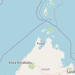
Map view of Tiga Island National Park

Use this park location map to pinpoint Tiga Island National Park in Malaysia, understand its exact geographic position, and read its mapped placement within the surrounding landscape more clearly.

Pigeon | © OpenStreetMap contributors

Location context for Tiga Island National Park

Sabah
Park atlas

Compare adjacent marine reserves, coastal geography, and regional protected areas.

Explore Parks Near Tiga Island National Park and Surrounding Protected Landscapes

Browse nearby national parks and protected areas to compare coastal terrain across the surrounding regional geography. Extending the discovery beyond Tiga Island National Park reveals connected marine habitats and related island ecosystems.
National parkMalaysia
Mapped park locations coincide#1 closest

Pulau Tiga National Park: A Protected Landscape within Malaysia's Geographic Context

Discover its mapped boundaries and regional natural terrain.

Pulau Tiga National Park stands as a distinct protected area, offering valuable insights into Malaysia's varied geography. This detail page is designed for structured discovery, highlighting the park's specific mapped boundaries and its contribution to the regional landscape context. Users exploring this national park will find a focused entry into understanding its protected status and its place within the atlas of Southeast Asian natural wonders.

National parkSabah
About 48 km away#2 closest

Northeast

Tunku Abdul Rahman National Park: Sabah National Park Protected Landscape & Geography

Explore mapped boundaries and regional context.

Tunku Abdul Rahman National Park, designated as a national park, offers a specific focus on protected landscape exploration within Sabah. This entity details its geographic footprint and its significance as a mapped natural area. Understanding its role within the regional geography allows for a more complete exploration of Malaysia's protected lands through an atlas perspective.

Area
49 km²
Established
1974
IUCN
II
Relief
Mixed relief
National parkMalaysia
About 54 km away#3 closest

East

Crocker Range National Park: A Protected Landscape within Malaysia's Borneo Region

Mapped boundaries and regional geography context for exploration.

Crocker Range National Park represents a significant protected area within Malaysia, contributing distinct geographic features and landscape context to the Borneo region. This detailed view supports atlas exploration by outlining the park's mapped boundaries and its role within the nation's protected lands. Understand the park's specific location and geographic identity, enriching your comprehension of Malaysian natural landscapes and conservation areas.

Area
1,399 km²
Established
1984
IUCN
II
Relief
Mountain
Nature reserveSabah
About 57 km away#4 closest

Northeast

Kota Kinabalu Wetland Centre: Protected Mangrove Landscapes in Sabah, Malaysia

An urban nature reserve and critical coastal wetland site

The Kota Kinabalu Wetland Centre stands as a preserved coastal mangrove fragment within the urban sprawl of Sabah's capital. This nature reserve provides a vital link between land and sea, offering a 1.5-kilometre boardwalk that allows for the observation of migratory bird populations and tidal mudflat ecosystems. As a designated Ramsar wetland, the site demonstrates the importance of small-scale conservation within fast-growing regional capital cities.

Area
0.24 km²
Established
1986
Relief
Lowland
Climate
Tropical
Nature reserveTemburong District
About 120 km away#5 closest

Southwest

Peradayan Forest Reserve Nature Reserve: Understanding its Protected Landscape and Geographic Setting

Explore mapped boundaries and the natural terrain of this Brunei reserve.

Peradayan Forest Reserve stands as a significant protected natural area within Brunei's Temburong District, an exclave characterized by vast tropical rainforests. This entry focuses on its identity as a nature reserve, providing key geographic context and details about its mapped boundaries. Understand its role within the regional landscape and how its protected status contributes to the conservation of Brunei's natural heritage, facilitating a deeper dive into atlas-style geographic exploration.

Area
26.5 km²
Relief
Upland
Climate
Tropical
Access
Moderate access
National parkMalaysia
About 121 km away#6 closest

Northeast

Kinabalu National Park: Mapped Boundaries and Protected Landscape Atlas

Exploring Malaysia's Natural Terrain and Park Geography

Delve into the specific protected area identity of Kinabalu National Park, situated within Malaysia. This resource details its geographic scope and mapped terrain, providing a foundation for understanding its role as a national park. Examine the park's protected landscape context, offering valuable insights for anyone exploring regional geography and conservation areas through an atlas lens.

Area
754 km²
Established
1964
IUCN
II
Visitors
611.6K annual
A pale, minimalist watercolor painting depicting a gentle, rolling landscape with green and light red washes, suggesting hills and distant foliage against a soft, bright background.
National parkSabah
About 121 km away#7 closest

Northeast

Kinabalu Park: Geographic Overview and Protected Landscape Mapping in Sabah, Malaysia

A study of vertical mountain terrain and biodiversity boundaries

Kinabalu Park stands as a defining natural entity in Sabah, Malaysia, characterized by its extreme elevation changes and concentration of rare botanical life. This atlas resource maps the park's physical geography, from its cloud-shrouded forests to its rocky summit plateaus, offering a detailed look at one of Southeast Asia's most significant protected mountain environments.

Area
754 km²
Established
1964
IUCN
II
Visitors
611.6K annual
Protected areaBrunei-Muara District
About 122 km away#8 closest

Southwest

Bukit Shahbandar Forest Recreation Park: Protected Area with Ridge Landscape & Hiking Trails

Explore Brunei's unique recreational forest terrain and mapped natural features.

Bukit Shahbandar Forest Recreation Park is a notable protected area within the Brunei-Muara District, distinguished by its prominent grassy ridge and a network of challenging hiking trails that traverse its varied terrain. The park's landscape is characterized by rolling hills, including peaks that reach nearly 470 feet, offering strategic vantage points. As a recreational forest, it provides a distinct example of protected land use, blending modified natural vegetation with opportunities for outdoor activity and geographic discovery. Its unique topography and trail system offer a clear focus for atlas-based exploration.

Area
2.34 km²
Established
1998
IUCN
II
Visitors
35.5K annual

Common questions about visiting, size, designation, and location context for Tiga Island National Park

Tiga Island National Park FAQs for park facts, access, geography, and protected area context

Find quick answers about Tiga Island National Park, including protected-area facts, park geography, trail and visitor context, and how the park fits into its surrounding country and regional landscape.
MoriAtlas Explorer

Continue Your Protected Areas Search Across the Global Atlas

Deepen your exploration by continuing the structured search for national parks and protected areas worldwide. Utilize the comprehensive filtering capabilities to compare different conservation landscapes and refine your understanding of global park geography. Discover more about the distribution and characteristics of protected natural areas.

Global natural geography