
Mori Atlas logo
Nature reserveTrzebiatowsko-Kołobrzeski Pas Nadmorski

A comprehensive atlas entry for the protected coastal dune, lagoon, and river estuary mosaic.

Trzebiatowsko-Kołobrzeski Pas Nadmorski: Mapped Protected Landscapes of the Baltic Coast

(Trzebiatowsko-Kołobrzeski Pas Nadmorski (PLH320017))

Trzebiatowsko-Kołobrzeski Pas Nadmorski forms an ecologically significant sixty-kilometer protected corridor along the Baltic Sea in northwestern Poland. This nature reserve features a classic sequence of white and grey dunes, stabilized crowberry-heath forests, coastal lagoons like Resko Przymorskie, and river-mouth wetlands within the Zachodniopomorskie region.

Baltic coastcoastal duneswhite dunesgrey dunesstabilized dunescoastal lagoon
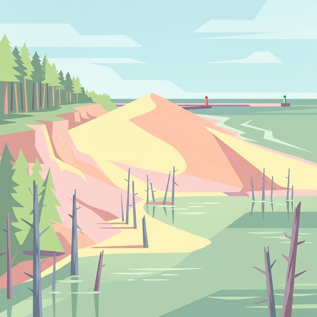
A flat vector-style digital illustration depicting a coastal landscape with sandy dunes, a forest edge, dead tree stumps in shallow water, and a distant breakwater with navigation beacons under a pale sky.

Trzebiatowsko-Kołobrzeski Pas Nadmorski

Nature reserve

Park overview

Structured park overview, official facts, and landscape profile for Trzebiatowsko-Kołobrzeski Pas Nadmorski

Trzebiatowsko-Kołobrzeski Pas Nadmorski park facts, protected area profile, and essential visitor context

Review the core facts for Trzebiatowsko-Kołobrzeski Pas Nadmorski, including designation, size, terrain, visitor scale, habitats, and operating context in one park-focused overview.

About Trzebiatowsko-Kołobrzeski Pas Nadmorski

Trzebiatowsko-Kołobrzeski Pas Nadmorski is a Special Area of Conservation in the Natura 2000 network, occupying a central stretch of the Polish Baltic coast in the West Pomeranian Voivodeship. It is framed by the sea on one side and the lowlands of the Gryficka and Białogardzka Plains on the other, with the mesoregions of the Trzebiatów Coast and Słowińskie Coast defining much of its geographic identity.

The site's defining character is its habitat zonation. From the shoreline inland, the landscape shifts through sandy beaches and patches of shingle known locally as kidzina, into embryonic dunes, white dunes, grey dunes, and ultimately stabilized dune ridges clothed in crowberry heath forest, known as bory bażynowe. Behind the dunes lie wet slacks with marshes, followed by coastal lagoons such as Resko Przymorskie and Liwia Łuża, which are cut off from the Baltic by narrow spits.

Inland from the dune belt, the area descends into the broad, peat-filled Baltic Pradolina, a former glacial meltwater valley now crossed by rivers including the Rega, Stara Rega, and Parsęta, along with a network of drainage channels. Although much of this lowland was historically drained and used as grassland, the degradation of hydraulic infrastructure has allowed secondary flooding and bog formation in places, contributing additional freshwater and slightly brackish wetland habitats.

In total, the protected landscape integrates cliffs, wide sandy beaches, dune ridges, spits, lagoons, peatlands, river estuaries, mixed forests, and fragments of more demanding woodland types such as sub-Atlantic oak-lime forest. The mosaic supports both sand-loving coastal flora and wetland-dependent fauna, making the area one of the more ecologically complete coastal belts in Poland. Although populated coastal towns such as Rewal, Niechorze, Mrzeżyno, Dźwirzyno, Grzybowo, Kołobrzeg, Sianożęty, and Ustronie Morskie are excluded from the designated area, their building lines form the boundary of the protection zone, ensuring a coherent coastal corridor remains intact.

Quick facts and research context for Trzebiatowsko-Kołobrzeski Pas Nadmorski

Trzebiatowsko-Kołobrzeski Pas Nadmorski is a Polish Natura 2000 Special Area of Conservation, designated under the EU Habitats Directive with the code PLH320017. It lies on the Baltic coast of the West Pomeranian Voivodeship, within the Szczecin Coastal Plain mesoregion.

The area covers roughly 174 square kilometers and stretches along about 60 kilometers of coastline from Trzęsacz in the west to Gąski in the east. It is not a single continuous block but a series of three functionally linked enclaves separated by towns and farmland. Its boundaries run from a few hundred meters up to about nine kilometers inland.

The protected landscape includes coastal cliffs, dunes, spits, lagoons, river estuaries, peat-filled glacial valleys, and mixed forests, making it one of the more ecologically diverse coastal belts in Poland.

Protection and recognition

Documented protection history, designation framework, and international recognition records

Trzebiatowsko-Kołobrzeski Pas Nadmorski Protection Status and Natura 2000 Recognition

Trzebiatowsko-Kołobrzeski Pas Nadmorski holds documented protection status established in 2018 alongside official Natura 2000 recognition records. Structured conservation metadata outlines the mixed protection scope and designation framework for this protected area.

International recognition

Protection details

Protection scope
Mixed
Designated year
2018
Transboundary protection
No
Park context

Deeper park guide and search-rich context for Trzebiatowsko-Kołobrzeski Pas Nadmorski

Trzebiatowsko-Kołobrzeski Pas Nadmorski history, landscape, wildlife, and travel context

Explore Trzebiatowsko-Kołobrzeski Pas Nadmorski through its history, landscape character, ecosystems, wildlife, conservation priorities, cultural context, and seasonal travel timing in a structured park guide built for atlas discovery and search intent.

Why Trzebiatowsko-Kołobrzeski Pas Nadmorski stands out

Trzebiatowsko-Kołobrzeski Pas Nadmorski is best known for its intact zonation of southern Baltic coastal habitats, progressing from open sea and beach through embryonic white dunes, grey dunes, stabilized forested dunes, and into wet dune slacks behind the dune ridges. This classic habitat sequence, rare in such continuity along the Polish coast, is the defining feature of the area. The site is also recognized for its coastal lagoons and river-mouth wetlands, especially Resko Przymorskie and Liwia Łuża, which act as the most important bird refuges within the belt. Combined with adjacent bog forest, floodplain forest, and sub-Atlantic oak-lime woodland fragments, the area forms a coastal mosaic that is ecologically richer than most other stretches of the Polish Baltic shore.
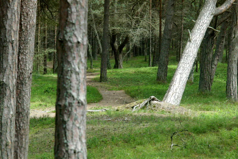
A narrow dirt path winds through a pine forest with grassy ground cover and several pine trees in the foreground and background.
A narrow trail winds through the crowberry pine forest, characteristic of the coastal landscape.

Trzebiatowsko-Kołobrzeski Pas Nadmorski history and protected-area timeline

Trzebiatowsko-Kołobrzeski Pas Nadmorski was first proposed and approved in 2008 by the European Commission as a Site of Community Importance under the EU Habitats Directive. In 2009, the Commission adjusted the protected area, reducing it from approximately 18,017 hectares to 17,468 hectares.

In 2018, the Polish Minister of the Environment formally confirmed the site through regulation as a Special Area of Conservation, giving it its current legal status within the Polish Natura 2000 network. A conservation task plan was established in 2014 and revised in 2017, setting out the ongoing management framework for the area.

The protected landscape itself reflects a longer history of human modification. Most of the peat-filled Baltic Pradolina was drained in earlier periods and used as agricultural grassland, and only the deterioration of old drainage infrastructure later allowed the partial return of bog and marsh conditions. Today, the area is administered jointly through regional environmental authorities, state forest districts, the maritime offices in Szczecin and Słupsk, and various local municipalities.

Trzebiatowsko-Kołobrzeski Pas Nadmorski landscape and geographic character

The landscape of Trzebiatowsko-Kołobrzeski Pas Nadmorski is shaped by the meeting of several distinct coastal and lowland physiographic units. Along the sea, the coastline alternates between cliffed sections and low, dune-fringed shores backed by narrow sandy plains.

The most visually characteristic landforms are the dune ridges. They follow a textbook sequence of white, grey, and stabilized dunes, often separated by wet slacks, low-lying mokradła, and patches of crowberry heath forest on the older, fixed dunes. The best-preserved dune forests are found between Mrzeżyno and Pogorzelica.

Behind the dunes lie the coastal lagoons Resko Przymorskie and Liwia Łuża, both enclosed from the open sea by long, narrow sand spits. They are connected hydrologically to the Baltic through shallow channels and behave as classic brackish-to-freshwater transition lakes.

Inland, the terrain drops into the wide, flat Baltic Pradolina, a former glacial valley now filled with peat and crossed by the Rega, Stara Rega, and Parsęta rivers, along with an extensive network of canals. Ground moraine elevations rise above parts of this lowland, supporting mesotrophic mixed forest on sandy substrates. The result is a pronounced layering of coastal, lagoon, peatland, and lowland forest landscapes within a single protected corridor.
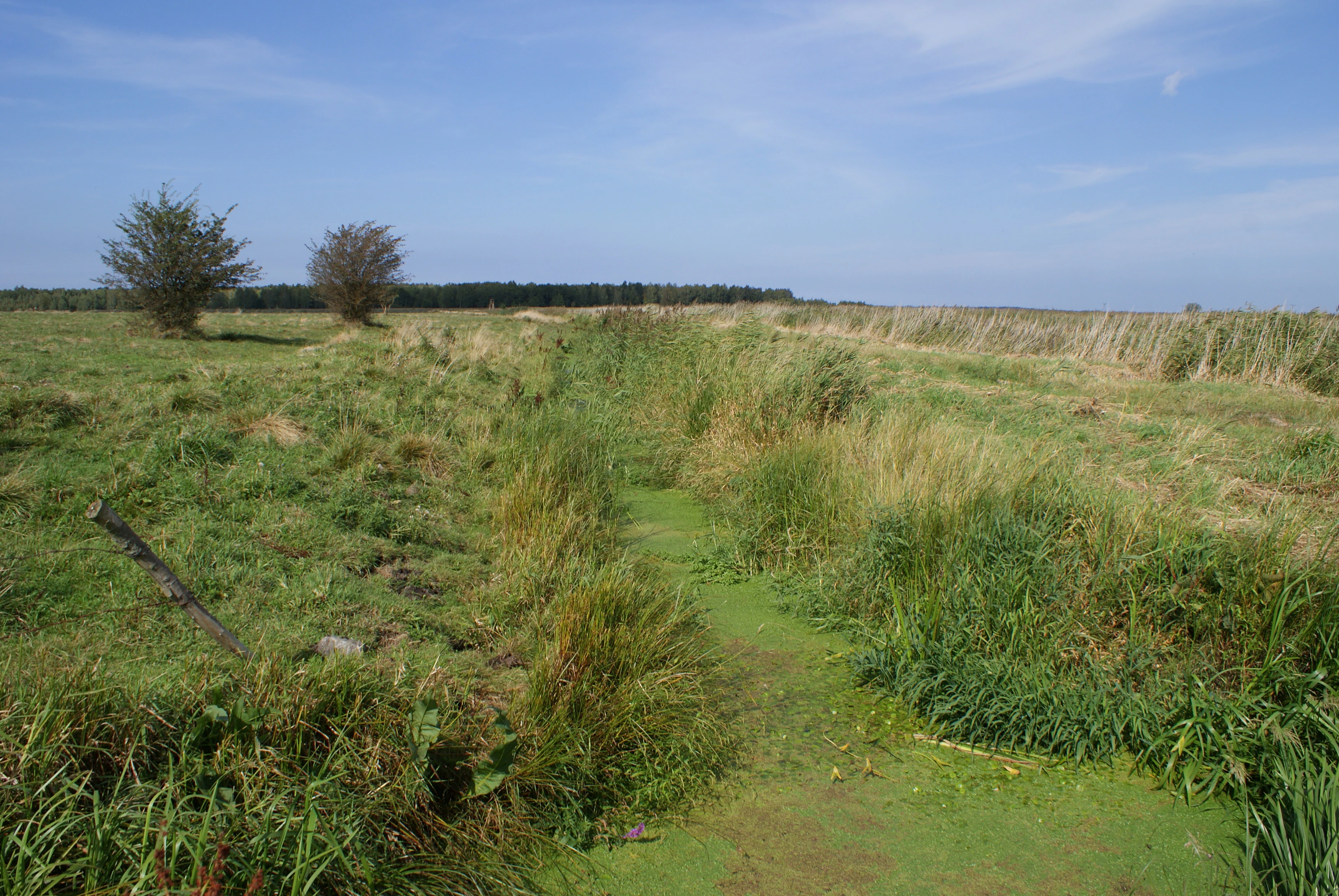
A wide shot of a flat, green coastal marshland area featuring a narrow, algae-covered water channel, some low-lying shrubs, and distant trees under a clear blue sky.
A view of the marshy landscape near the Mrzezyno II Canal within the Trzebiatowsko-Kołobrzeski Pas Nadmorski.

Trzebiatowsko-Kołobrzeski Pas Nadmorski ecosystems, habitats, and plant life

Trzebiatowsko-Kołobrzeski Pas Nadmorski supports seventeen officially recorded natural habitat types. The most prominent are Baltic coastal salt marshes, embryonic shifting dunes with marram grass, white dunes, grey dunes, stabilized dunes with crowberry vegetation, humid dune slacks, and willow scrub along riverbanks.

Further inland, the area preserves riverine floodplain forests, sub-Atlantic oak-lime woodland on richer soils, and bog forest communities on peat substrates. Around the coastal lagoons and along rivers such as the Rega and Parsęta, freshwater and slightly brackish plant communities thrive, including halophytic species typical of saline-influenced habitats.

Sand-loving plant communities dominate the beach and dune zones, with lichens and specialized grasses on the grey dunes, maritime sea holly, and the early stages of crowberry heath forest forming toward the landward side. Where groundwater rises in dune slacks, wet-loving vegetation takes over, producing a sharp ecological contrast within a very short horizontal distance.

Trzebiatowsko-Kołobrzeski Pas Nadmorski wildlife and species highlights

Wildlife in Trzebiatowsko-Kołobrzeski Pas Nadmorski is shaped by the alternation between marine, lagoonal, riverine, and forested habitats. The coastal lagoons, in particular Liwia Łuża, Konarzewo, and Resko Przymorskie, serve as the most significant bird refuges within the area, attracting waterbirds that favor shallow, sheltered waters with both freshwater and brackish character.

Around Liwia Łuża, between Włodarka and Mrzeżyno, and to the southwest of Dźwirzyno and Kołobrzeg, the area supports bog forest and floodplain forest communities that add structural variety for woodland and wetland fauna. The combination of wet dune slacks, river estuaries, and forested dunes creates a gradient of habitats that supports breeding birds, migratory species, and a range of smaller fauna typical of Polish coastal ecosystems.

Trzebiatowsko-Kołobrzeski Pas Nadmorski conservation status and protection priorities

Trzebiatowsko-Kołobrzeski Pas Nadmorski is part of the European Natura 2000 network and was designated specifically to maintain the southern Baltic's characteristic habitat sequence, including coastal saltmarshes, dune ecosystems, riverine willow scrub, floodplain forests, and sub-Atlantic oak-lime woodland, all of which are priorities under the EU Habitats Directive.

The site overlaps partially with the Trzebiatów Coast Special Protection Area for birds (PLB320010), reinforcing its value for both habitat and species conservation. Five nature reserves lie within or adjacent to the area: Roby, Nadmorski bór bażynowy w Mrzeżynie, Wydmy między Dźwirzynem a Grzybowem, Stramniczka, and Jezioro Liwia Łuża, together with the Ekopark Wschodni ecological area and part of the Koszaliński Pas Nadmorski Protected Landscape Area.

Conservation responsibility is shared across regional environmental authorities, state forest districts, the maritime offices in Szczecin and Słupsk, and the relevant municipalities. A formal conservation task plan was established in 2014 and revised in 2017, structuring ongoing protection for the dune system, lagoons, peatlands, and associated forest communities.

Top sights and standout views in Trzebiatowsko-Kołobrzeski Pas Nadmorski

The clearest highlight of Trzebiatowsko-Kołobrzeski Pas Nadmorski is its almost continuous belt of southern Baltic coastal habitats, where beach, white dunes, grey dunes, and stabilized crowberry-heath dunes follow one another in an unusually complete sequence. The dune forests between Mrzeżyno and Pogorzelica are among the best preserved stretches of this habitat type along the Polish coast.

The coastal lagoons Resko Przymorskie and Liwia Łuża, together with the peat-filled Baltic Pradolina crossed by the Rega and Parsęta, add a second highlight: a layered mosaic of brackish lagoons, river estuaries, bog forest, and floodplain forest. The combination of dunes, lagoons, river mouths, and mixed forest within a single protected corridor makes this one of the most ecologically inclusive coastal conservation areas in Poland.

Best time to visit Trzebiatowsko-Kołobrzeski Pas Nadmorski

Because the dunes, lagoons, and forests of Trzebiatowsko-Kołobrzeski Pas Nadmorski are largely accessible from surrounding coastal towns, the timing of a visit affects the experience mostly through weather, waterbird presence, and dune vegetation. Late spring and early summer bring the most active birdlife around the lagoons and wet dune slacks, while late summer and early autumn offer milder weather, more stable dune trails, and a calmer atmosphere overall.

Winter visits reveal the open structure of the dune belt and large numbers of waterbirds on the unfrozen lagoons, though coastal winds and shorter days reduce comfort. The protected area itself is not a heavily managed visitor destination, so visitors typically approach it on foot from neighboring settlements along the West Pomeranian coast.

Monthly climate preview

Long-term representative monthly temperature and precipitation data for Trzebiatowsko-Kołobrzeski Pas Nadmorski

Trzebiatowsko-Kołobrzeski Pas Nadmorski Climate Normals and Annual Temperature Rhythm

Representative coordinates record sub-zero winter minimums alongside warm summer peaks reaching average maximums near 28 degrees Celsius with steady monthly precipitation. Reviewing the complete twelve-month record reveals detailed temperature swings and rainfall patterns across the protected landscape.
Annual mean9 °C
0 °C18 °C
Jan
Feb
Mar
Apr
May12°
Jun16°
Jul18°
Aug18°
Sep15°
Oct10°
Nov
Dec
Warmest month
August

18.4 °C

Coolest month
January

-0.1 °C

Wettest month
July

2.6 mm/day

Driest month
April

1.2 mm/day

Park location guide

Geography guide, regional context, and park location map for Trzebiatowsko-Kołobrzeski Pas Nadmorski

Trzebiatowsko-Kołobrzeski Pas Nadmorski park geography, regions, and map view in Poland

Understand where Trzebiatowsko-Kołobrzeski Pas Nadmorski sits in Poland through a broader geographic reading of the surrounding landscape, nearby location context, and its mapped position within the national park landscape.

How Trzebiatowsko-Kołobrzeski Pas Nadmorski fits into Poland

Poland, officially the Republic of Poland, is a Central European country spanning from the Baltic Sea in the north to the Carpathian Mountains in the south. It borders Germany, Czech Republic, Slovakia, Ukraine, Belarus, Lithuania, and Kaliningrad Oblast. The country has a temperate climate, diverse landscapes, and is known for its rich history, cultural heritage, and strong economic position within the EU.

Wider geography shaping Trzebiatowsko-Kołobrzeski Pas Nadmorski in Poland

Poland occupies 312,696 km2 in Central Europe, extending from the Baltic Sea coast in the north to the Sudetes and Carpathian Mountains in the south. It borders Germany to the west, Czech Republic and Slovakia to the south, Ukraine and Belarus to the east, and Lithuania and Kaliningrad Oblast to the northeast. The landscape includes lowland plains, uplands, and mountain ranges.

Map view of Trzebiatowsko-Kołobrzeski Pas Nadmorski

Use this park location map to pinpoint Trzebiatowsko-Kołobrzeski Pas Nadmorski in Poland, understand its exact geographic position, and read its mapped placement within the surrounding landscape more clearly.

Pigeon | © OpenStreetMap contributors

Location context for Trzebiatowsko-Kołobrzeski Pas Nadmorski

Zachodniopomorskie

Visualizing the active dunes, coastal lagoons, and protected habitats of the Baltic shore.

Trzebiatowsko-Kołobrzeski Pas Nadmorski Photos and Coastal Scenery

Photographic records capture the complete zonation of white dunes, grey dunes, and stabilized forests across the protected coastal belt. Visual documentation reveals the distinct terrain of brackish lagoons, river estuaries, and low-lying peatlands shaping the region.

A narrow dirt path winds through a pine forest with grassy ground cover and several pine trees in the foreground and background.

A wide sandy beach meeting the Baltic Sea, flanked by a steep, pine-covered coastal dune ridge on the left under a blue sky.

A wide shot of a flat, green coastal marshland area featuring a narrow, algae-covered water channel, some low-lying shrubs, and distant trees under a clear blue sky.

Park atlas

Compare nearby regional parks and connected protected landscapes along the Baltic shore

Parks Near Trzebiatowsko-Kołobrzeski Pas Nadmorski and Surrounding Coastal Protected Areas

Browsing other protected areas near Trzebiatowsko-Kołobrzeski Pas Nadmorski reveals a broader continuum of Baltic coastal habitats and lowland river valleys. Expanding the geographic comparison helps trace regional ecological corridors across the surrounding West Pomeranian landscape.
A soft watercolor painting depicting a calm shoreline with rolling hills and trees in the distance.
Nature reservePoland
Park boundaries overlap#1 closest

Northwest

Ostoja na Zatoce Pomorskiej: Mapping the Pomeranian Bay Marine Nature Reserve

Extensive marine protected landscape in the Baltic Sea

Ostoja na Zatoce Pomorskiej encompasses over 243,000 hectares of the southern Baltic Sea, serving as a primary marine nature reserve for the Polish coast. The sanctuary is defined by complex underwater features such as shallow sandy banks, gravel plains, and the prominent Odrzańska Ławica, which collectively support essential migratory waterbird populations and protected aquatic species within the European ecological network.

Area
2,430.59 km²
Established
2009
Relief
Lowland
Scope
Marine
Protected areaWest Pomeranian Voivodeship
Park boundaries overlap#2 closest

Southwest

Wybrzeże Trzebiatowskie Protected Area: Coastal Wetlands and Baltic Shoreline Map

A diverse wetland corridor in the West Pomeranian Voivodeship.

Wybrzeże Trzebiatowskie represents a significant stretch of the Baltic coastline, characterized by a narrow and elongated geographic profile. The protected landscape highlights a complex interplay of lagoon lakes, river floodplains, and classic dune systems, providing critical habitat within the broader West Pomeranian regional geography.

Area
317.576 km²
Established
2007
Relief
Lowland
Scope
Mixed
Nature reserveWest Pomeranian Voivodeship
About 8.8 km away#3 closest

Southeast

Mszar koło Siemidarżna Nature Reserve: Geography and Protected Wetland Landscapes

Mapping the peatland ecosystems of West Pomeranian Voivodeship

Examine the ecological and geographical profile of Mszar koło Siemidarżna. This nature reserve provides essential insight into the preservation of raised bogs and transitional mires in the lowlands of northwestern Poland. The site highlights the importance of buffer zones in maintaining hydrological integrity for protected pine woodland and rare bog plant species.

Area
0.209 km²
Established
2011
Relief
Lowland
Climate
Temperate
Protected areaZachodniopomorskie
13 km away#4 closest

Southwest

Ujście Odry i Zalew Szczeciński: Protected Area Geography and Estuarine Landscape Mapping

Coastal lagoons, riverine deltas, and island habitats in Zachodniopomorskie.

This extensive protected area offers a comprehensive view of the Oder estuary as it meets the Baltic Sea. The landscape comprises broad lagoons, branching river channels, and coastal islands that provide crucial habitat for migratory waterbirds and sustain a rare brackish water ecosystem. Use this geographic entry to analyze the boundaries, terrain, and interconnected waterways of this major Polish nature site.

Area
526.12 km²
Established
2008
Relief
Lowland
Scope
Mixed
Watercolor painting depicting mountains, rivers, and green terrain
National parkWest Pomeranian Voivodeship
23 km away#5 closest

West

Wolin National Park: Coastal Protected Landscape and Glacial Terrain in West Pomeranian Voivodeship

Explore Poland's first marine national park and its dynamic geography.

Wolin National Park offers a profound look into Poland's protected coastal geography. This national park in the West Pomeranian Voivodeship is distinguished by its high sea cliffs, inclusion of Baltic Sea and Szczecin Lagoon waters as Poland's first marine protected area, and a landscape sculpted by glacial moraines. Discover the park's complex delta systems, ancient forests, and the mapped terrain that supports significant bird migration, providing a rich focus for atlas exploration.

Area
109.37 km²
Established
1960
IUCN
II
Visitors
1.5M annual
National parkZachodniopomorskie Voivodeship
23 km away#6 closest

West

Woliński Park Narodowy: Atlas Overview of Protected Coastal and Marine Environments

Examining moraine landscapes and marine park boundaries.

Woliński Park Narodowy stands as a critical protected area in the Zachodniopomorskie Voivodeship, blending terrestrial moraine ridges with marine ecosystems. This atlas entry provides geographic context for its coastal cliffs, inland lake district, and the expansive river delta that supports rare avian species.

Area
109.37 km²
Established
1960
Visitors
1.5M annual
Relief
Upland
Protected areaWest Pomeranian Voivodeship
25 km away#7 closest

East

Wiązogóra Protected Area: Geography and Wetland Habitat Mosaic in West Pomeranian Voivodeship

Exploring the ecological significance of a post-glacial lowland mire landscape

Wiązogóra forms an intricate network of twelve bog and mire vegetation complexes situated within the Równina Białogardzka. This site showcases a diverse assembly of dystrophic ponds, transitional mires, and acidophilous beech and oak woodlands, providing a distinct study in northern European wetland conservation and regional post-glacial topography.

Area
4.9 km²
Established
2011
Relief
Lowland
Climate
Temperate
Nature reserveWest Pomeranian Voivodeship
About 27 km away#8 closest

Southeast

Rezerwat przyrody Bagno Iglickie: Protected Peatland and Wetland Landscape in West Pomerania

Mapped geography of a glacial basin and nature reserve

Rezerwat przyrody Bagno Iglickie represents a crucial protected area in northwestern Poland, centering on a post-lake basin characterized by active peat-forming processes. This site offers significant value for understanding regional wetland geography, featuring alkaline fens and spring-fed moss meadows preserved within the West Pomeranian landscape.

Area
0.46 km²
Established
2016
Relief
Lowland
Access
Remote access

Common questions about visiting, size, designation, and location context for Trzebiatowsko-Kołobrzeski Pas Nadmorski

Trzebiatowsko-Kołobrzeski Pas Nadmorski FAQs for park facts, access, geography, and protected area context

Find quick answers about Trzebiatowsko-Kołobrzeski Pas Nadmorski, including protected-area facts, park geography, trail and visitor context, and how the park fits into its surrounding country and regional landscape.
MoriAtlas Explorer

Continue Your Protected Areas Search Across the Global Atlas

Deepen your exploration by continuing the structured search for national parks and protected areas worldwide. Utilize the comprehensive filtering capabilities to compare different conservation landscapes and refine your understanding of global park geography. Discover more about the distribution and characteristics of protected natural areas.

Global natural geography