Mori Atlas logo
Nature reserveRéserve naturelle intégrale de Tsaratanana

Understanding the crystalline topography and mountainous landscape of northern Madagascar

Réserve naturelle intégrale de Tsaratanana: Mapping the Highest Peak and Protected Highland Massif

The Réserve naturelle intégrale de Tsaratanana serves as a critical geographic landmark, encompassing the rugged high-altitude massif that holds the summit of Maromokotro at 2,876 meters. This protected area within the Diana region showcases deep crystalline valleys and diverse montane habitats, functioning as a vital conservation landscape in northern Madagascar. By analyzing the terrain and boundaries, users can trace the complex physical geography that defines this long-standing highland reserve.

strict nature reservehighland massifmountain ecosystemsMadagascar highest peaklemur habitatprimate conservation

Réserve naturelle intégrale de Tsaratanana

Nature reserve

Park overview

Structured park overview, official facts, and landscape profile for Tsaratanana Strict Nature Reserve

Tsaratanana Strict Nature Reserve park facts, protected area profile, and essential visitor context

Review the core facts for Tsaratanana Strict Nature Reserve, including designation, size, terrain, visitor scale, habitats, and operating context in one park-focused overview.

About Tsaratanana Strict Nature Reserve

Tsaratanana Strict Nature Reserve sits in the far north of Madagascar, straddling the regions of Diana, Sava, and Sofia, and forming part of the broader province historically known as Diego-Suarez. The reserve lies approximately 120 kilometers from Antsiranana, the main regional city, and protects a substantial portion of the Tsaratanana Massif, a mountainous complex that dominates the local landscape.

The defining geographical feature of the reserve is Maromokotro, which at 2,876 meters is the highest peak in Madagascar. The massif is geologically built from crystalline rocks assigned to the Vohibory formation, creating a landscape of deep valleys, ridges, and elevated plateaus. The terrain transitions from lower forested slopes up to montane and summit-level environments.

Ecologically, Tsaratanana is renowned for its primate fauna. The reserve supports multiple lemur species, including both well-studied and more elusive forms, contributing to its importance for mammal conservation in Madagascar. Administratively, the reserve has been protected since 1927, making it one of the older entries in Madagascar's formal protected-area network, and today it is managed within the country's strict nature reserve and national park system under Madagascar National Parks.

Because of its elevation, isolation, and biological richness, Tsaratanana continues to attract scientific interest as a site for understanding the distribution and survival of Madagascar's endemic wildlife in highland habitats.

Quick facts and research context for Tsaratanana Strict Nature Reserve

Tsaratanana Strict Nature Reserve lies in northern Madagascar, within the Diana, Sava, and Sofia regions, and extends across roughly 48,622 hectares. The reserve contains Maromokotro, Madagascar's highest summit, reaching 2,876 meters above sea level.

The massif is built from crystalline rocks belonging to the Vohibory geological formation, giving the area a complex and ancient substrate. Created in 1927, the reserve holds the strictest IUCN protection category (Ia) and has long served as a refuge for lemurs, including the black lemur, aye-aye, fork-marked lemur, and several mouse lemur and sportive lemur species.

Protection and recognition

Examine documented protection metrics, designation records, and administrative management scope.

Réserve naturelle intégrale de Tsaratanana Protection Status and Protected Area Documentation

Consolidated protection metrics and designation records offer a structured view of Réserve naturelle intégrale de Tsaratanana administration. Official conservation registries provide verified baseline data for analyzing protected area governance and international database records.

Protection details

WDPA ID
2306
Park context

Deeper park guide and search-rich context for Tsaratanana Strict Nature Reserve

Tsaratanana Strict Nature Reserve history, landscape, wildlife, and travel context

Explore Tsaratanana Strict Nature Reserve through its history, landscape character, ecosystems, wildlife, conservation priorities, cultural context, and seasonal travel timing in a structured park guide built for atlas discovery and search intent.

Why Tsaratanana Strict Nature Reserve stands out

Tsaratanana is best known for sheltering Maromokotro, the highest point in Madagascar, and for protecting an exceptionally diverse primate community within its highland forests that include several diurnal and nocturnal lemurs. The reserve has become a reference site for conservationists interested in the survival of endemic Malagasy mammals, and is also recognized for its rugged crystalline massif terrain. This combination of summit-level habitats and primate-rich forests gives Tsaratanana a distinctive profile among Madagascar's protected areas.

Tsaratanana Strict Nature Reserve history and protected-area timeline

The Tsaratanana massif was first documented in 1899 by a northern Madagascar geodetic mission, which explored and mapped the range during a July expedition. This early scientific work laid the groundwork for later recognition of the area as a region of outstanding natural value.

In 1903, the expedition of P. Lemoine traveled into the massif, but its passage triggered a major fire that significantly damaged the high-altitude vegetation of the Tsaratanana mountains. This historical event is often referenced as a turning point that highlighted both the ecological importance of the area and its vulnerability to disturbance.

Formal protection came in 1927, when the Tsaratanana reserve was established as an integral natural reserve, codifying its status as one of the key early protected sites of Madagascar. Over the following decades, the area has been sustained as a strict nature reserve and has retained its position within the national system of protected areas managed by Madagascar National Parks.

Tsaratanana Strict Nature Reserve landscape and geographic character

The Tsaratanana landscape is dominated by a high, rugged massif composed of ancient crystalline rocks of the Vohibory formation. The terrain rises sharply from surrounding lowlands to culminate in Maromokotro, Madagascar's highest peak at 2,876 meters.

The massif is dissected by deep valleys and steep slopes, producing a complex topography where elevation changes significantly over short distances. Lower elevations are typically cloaked in dense forest cover, while the higher elevations transition into more open montane vegetation, shaped by both climate and the historical disturbance from early 20th-century fires.

Tsaratanana Strict Nature Reserve ecosystems, habitats, and plant life

Tsaratanana's ecological character is shaped strongly by its elevation gradient, which generates distinct vegetation zones from lowland slopes through to high-altitude summit environments. The reserve's combination of isolated highland habitats and large connected forested areas creates conditions favorable for a wide range of endemic species.

The massif functions as an ecological island within northern Madagascar, with habitats that vary from humid montane forest to more open elevated areas. This habitat heterogeneity is one of the main reasons the reserve supports such a diverse primate community, and also contributes to its broader value for endemic flora and fauna.

Tsaratanana Strict Nature Reserve wildlife and species highlights

The Tsaratanana Strict Nature Reserve is especially notable for its primate populations, supporting a significant share of Madagascar's lemur diversity. Among the species recorded within the reserve are the black lemur, the fork-marked lemur (Phaner), the aye-aye, the western bamboo lemur, the greater dwarf lemur, the brown lemur, and the weasel sportive lemur.

Several mouse lemur species (Microcebus) are also present, adding to the reserve's importance for nocturnal primate conservation. The combination of diurnal and nocturnal lemur species, alongside other forest-dependent fauna, cements Tsaratanana's role as one of the key sites for primate conservation in Madagascar.

Tsaratanana Strict Nature Reserve conservation status and protection priorities

Tsaratanana holds the IUCN Category Ia designation, the strictest level of protected-area classification, reflecting its status as a strict nature reserve where ecological processes are given priority. This protection has been in place since 1927, making it one of the longest-standing conservation designations in Madagascar.

The reserve plays a crucial role in protecting endemic primate populations that are otherwise under pressure from habitat loss elsewhere in Madagascar. Its elevated and relatively isolated terrain offers a measure of natural protection, while its formal reserve status places it within the country's principal conservation framework administered by Madagascar National Parks.

Top sights and standout views in Tsaratanana Strict Nature Reserve

Tsaratanana Strict Nature Reserve combines Madagascar's highest summit with one of the country's most important primate habitats, all within a rugged crystalline massif in the far north of the island. Its long-standing protection since 1927 and strict IUCN reserve status underscore its national conservation value.

The reserve's defining value lies in the fusion of dramatic highland geography with exceptional biodiversity, especially lemurs, making it both a geographic landmark and a cornerstone of Madagascar's natural heritage.
Monthly climate preview

Long-term temperature ranges and precipitation rhythm across representative coordinates

Climate Normals and Annual Weather Patterns at Réserve naturelle intégrale de Tsaratanana

Representative coordinate records show measured multi-year temperature variations and monthly precipitation averages spanning a full twelve-month cycle. Examining the complete monthly climate profile reveals specific shifts between warmer thermal periods and drier conditions.
Annual mean21 °C
18 °C23 °C
Jan22°
Feb22°
Mar22°
Apr22°
May20°
Jun18°
Jul18°
Aug18°
Sep20°
Oct22°
Nov23°
Dec22°
Warmest month
November

22.9 °C

Coolest month
July

17.8 °C

Wettest month
January

14.3 mm/day

Driest month
August

0.9 mm/day

Park location guide

Geography guide, regional context, and park location map for Tsaratanana Strict Nature Reserve

Tsaratanana Strict Nature Reserve park geography, regions, and map view in Madagascar

Understand where Tsaratanana Strict Nature Reserve sits in Madagascar through a broader geographic reading of the surrounding landscape, nearby location context, and its mapped position within the national park landscape.

How Tsaratanana Strict Nature Reserve fits into Madagascar

Madagascar is an island nation in the Indian Ocean, positioned off the southeastern coast of Africa. As the world's fourth-largest island and second-largest island country, it stands out for its exceptional biodiversity, over 90% of its wildlife is endemic, making it one of 17 megadiverse countries. The population is approximately 32 million, with Antananarivo as both the capital and largest city.

Wider geography shaping Tsaratanana Strict Nature Reserve in Madagascar

Madagascar lies in the Indian Ocean off the southeastern coast of Africa, separated from the mainland by the Mozambique Channel. The island is situated approximately 400 km from the African continent. As the world's fourth-largest island, it also includes numerous smaller peripheral islands.

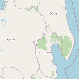
Map view of Tsaratanana Strict Nature Reserve

Use this park location map to pinpoint Tsaratanana Strict Nature Reserve in Madagascar, understand its exact geographic position, and read its mapped placement within the surrounding landscape more clearly.

Pigeon | © OpenStreetMap contributors

Location context for Tsaratanana Strict Nature Reserve

Diana
Park atlas

Compare nearby highland masses, rugged mountain ecosystems, and protected northern landscapes

Other Parks Near Réserve naturelle intégrale de Tsaratanana and Surrounding Protected Areas

Browse nearby protected areas and regional reserves connected to the high crystalline terrain surrounding Réserve naturelle intégrale de Tsaratanana. Expanding the geographic comparison reveals broader ecological patterns across the northern mountain landscapes of Madagascar.
Wildlife reserveDiana
About 55 km away#1 closest

West

Manongarivo Special Reserve: Protected Wildlife and River Landscapes in Northern Madagascar

Examining the humid forest terrain and geographic boundaries of the Diana region

Located in the Diana region, Manongarivo Special Reserve serves as a critical protected area within the northern humid rainforest system of Madagascar. The territory is defined by steep forested hills, narrow river valleys, and diverse ecological niches. By analyzing its specific topographic markers and river systems, this entry details the natural landscape and protected status of this significant biodiversity reserve.

Area
327.35 km²
Established
1956
IUCN
IV
Climate
Tropical
National parkMadagascar
About 85 km away#2 closest

Northwest

Lokobe National Park: Madagascar's Protected Natural Landscape and Geographic Context

Explore mapped boundaries and regional park geography.

Lokobe National Park is a protected national park situated within Madagascar, an island country recognized globally for its exceptional biodiversity and unique ecosystems. This page offers a detailed, atlas-oriented perspective on Lokobe National Park, focusing on its designation as a protected area, its specific geographic location, and the natural landscape features that define its territory. Users can explore the park's mapped boundaries and understand its contribution to Madagascar's remarkable natural heritage.

Area
15.23 km²
Established
1927
IUCN
II
Climate
Tropical
National parkMadagascar
About 85 km away#3 closest

Northwest

Nosy Tanikely National Park: Madagascar National Park & Protected Landscape Identity

Mapped geography and regional park context in Madagascar.

Nosy Tanikely National Park is a designated national park in Madagascar, offering a focused entry point for understanding protected land geography. As a key entity within the island's conservation landscape, it provides valuable context for exploring mapped park boundaries and regional geographic features. Discover how this protected area contributes to the broader atlas of Madagascar's natural heritage.

Area
3.41 km²
Established
2011
Relief
Lowland
Climate
Tropical
Wildlife reserveSava
About 103 km away#4 closest

Southeast

Réserve spéciale d'Anjanaharibe-Sud: Geography and Protected Area Landscape Overview

Deep forest terrain and mountain ridges in the Sava region

Situated in northeastern Madagascar, Réserve spéciale d'Anjanaharibe-Sud encompasses dense evergreen forests and steep mountain terrain. This protected area serves as a significant conservation landscape for rare endemic species, providing a high-elevation habitat that climbs dramatically from 500 meters to peaks above 2,000 meters across the Sava region.

Area
182.56 km²
Established
1958
IUCN
IV
Relief
Mountain
A watercolor landscape illustration depicting green bushes and grey, jagged rock formations under a soft pink and yellow sky.
Nature reserveDiana Region
About 106 km away#5 closest

North

Ankarana Special Reserve: A Detailed Geographic Atlas of the Diana Region's Limestone Plateau

Mapping the karst landscape, subterranean rivers, and cliff formations.

Examine the rugged topography of Ankarana Special Reserve, featuring a 25-kilometre-long cliff known as the Wall of Ankarana and 100 kilometres of mapped cave passages. This protected area offers deep insight into Madagascar's geological history and rare endemic lemur habitats within its dense, jagged tsingy ridges.

Area
182 km²
Established
1956
IUCN
IV
Relief
Upland
Watercolor painting of a mountainous landscape with green vegetation, a body of water, and distant peaks under a light sky
National parkMadagascar
About 106 km away#6 closest

Southeast

Marojejy National Park: A Protected National Park within Madagascar's Unique Geography

Mapped landscape context and regional protected area significance.

Marojejy National Park is a distinct protected area offering rich insights into Madagascar's natural geography. As a national park, its mapped boundaries define a significant landscape that contributes to the island nation's reputation as a biodiversity hotspot. This entry provides essential context for understanding Marojejy National Park's role within the country's protected lands and its value for structured geographic atlas exploration.

Area
555 km²
Established
1998
IUCN
II
Relief
Mountain
National parkMadagascar
About 130 km away#7 closest

West

Sahamalaza National Park: A Key National Park and Ramsar Wetland in Madagascar

Explore Madagascar's unique protected landscape and biodiversity hotspot

Sahamalaza National Park is a significant protected area in Madagascar, designated as both a National Park and an internationally important Ramsar Wetland. It protects vital transitional forest ecosystems and extensive coastal wetland habitats, offering a crucial refuge for critically endangered lemur species and migratory birds. The park's unique geography and ecological role provide rich context for understanding Madagascar's celebrated endemic biodiversity and conservation efforts through mapped landscape exploration.

Area
260.35 km²
Established
2007
IUCN
II
Climate
Tropical
Wildlife reserveDiana
About 132 km away#8 closest

Northeast

Réserve spéciale d'Analamerana: Mapped Geography and Protected Karst Ecosystems

Northern Madagascar wilderness and dry forest topography

Navigate the rugged limestone corridors and canyon networks of Réserve spéciale d'Analamerana. This protected area showcases a distinctive dry forest landscape shaped by seasonal tropical climates and serves as a critical habitat for rare endemic species within the Diana region.

Area
347 km²
Established
1956
IUCN
IV
Relief
Upland

Common questions about visiting, size, designation, and location context for Tsaratanana Strict Nature Reserve

Tsaratanana Strict Nature Reserve FAQs for park facts, access, geography, and protected area context

Find quick answers about Tsaratanana Strict Nature Reserve, including protected-area facts, park geography, trail and visitor context, and how the park fits into its surrounding country and regional landscape.
MoriAtlas Explorer

Continue Your Protected Areas Search Across the Global Atlas

Deepen your exploration by continuing the structured search for national parks and protected areas worldwide. Utilize the comprehensive filtering capabilities to compare different conservation landscapes and refine your understanding of global park geography. Discover more about the distribution and characteristics of protected natural areas.

Global natural geography