Mori Atlas logo
Marine protected areaTun Mustapha Marine Park

Mapping the island clusters, coral reef systems, and coastal biodiversity of northern Sabah

Tun Mustapha Marine Park: A Comprehensive Geographic Profile of Malaysia's Extensive Protected Marine Landscape

Tun Mustapha Marine Park spans the northern coast of Sabah, encompassing over fifty islands and islets within a complex multi-zoned protected maritime environment. This atlas-focused profile examines the park's expansive bathymetry, ranging from shallow reef flats to deeper pelagic channels, and its vital role in the wider Coral Triangle region. Understanding the fragmented geography of major islands such as Banggi, Balambangan, and Malawali provides insight into one of Malaysia's largest marine protected areas.

marine parkislandscoral reefsCoral Trianglesea turtlesdolphins

Tun Mustapha Marine Park

Marine protected area

Park overview

Structured park overview, official facts, and landscape profile for Tun Mustapha Marine Park

Tun Mustapha Marine Park park facts, protected area profile, and essential visitor context

Review the core facts for Tun Mustapha Marine Park, including designation, size, terrain, visitor scale, habitats, and operating context in one park-focused overview.

About Tun Mustapha Marine Park

Tun Mustapha Marine Park is a marine protected area situated in the waters off the north coast of Sabah, on the northern tip of Borneo in Malaysia. Its geographic footprint spans the Kudat, Pitas, and Kota Marudu districts, encompassing a diverse seascape of islands, islets, reefs, and coastal fringes. With an area approaching nine thousand square kilometres, it is the second largest gazetted marine park in the country, following the Luconia Shoals in Sarawak, and one of the largest marine protected areas in the wider Coral Triangle region.

The park includes more than fifty islands and islets, with the three major islands of Banggi, Balambangan, and Malawali forming the largest landmasses within its boundaries. These islands, along with the surrounding waters, are integral to the functioning of the broader marine ecosystem along the north Bornean coast. The park's management structure divides the area into four zones: a protection zone, a community use zone, a multiple-use zone, and a commercial fishing zone. This zoning approach reflects an awareness that the surrounding coastal population depends heavily on the marine environment for food, livelihoods, and cultural identity.

Roughly eighty thousand people are estimated to depend on the resources of the marine park. These communities include indigenous Sabah groups such as the Dusun and Rungus, along with Filipino-origin communities including the Sama-Bajau and Suluk. The presence of these diverse coastal communities underscores the importance of inclusive governance and the blending of conservation planning with traditional resource use.

Ecologically, the park sits within the Coral Triangle and supports extensive coral reef systems, productive coastal waters, and habitats for a range of marine megafauna. Its waters and coastlines host several dolphin species, marine turtles, rays, and pelagic fish, while elasmobranchs such as sharks and rays remain widespread and are commonly seen in nearby markets. By combining ecological protection, community involvement, and integration into regional marine conservation frameworks, Tun Mustapha Marine Park functions as a flagship example of how large, biologically rich tropical marine areas can be managed in collaboration with the people who have lived alongside them for generations.

Quick facts and research context for Tun Mustapha Marine Park

Tun Mustapha Marine Park lies off the north coast of Sabah in Malaysian Borneo, stretching across the Kudat, Pitas, and Kota Marudu districts. It is organised into four management zones: protection, community, multiple-use, and commercial fishing, reflecting its role as both a conservation area and a working seascape for surrounding communities. Managed by Sabah Parks, the area forms part of wider regional frameworks including the Sulu-Sulawesi Marine Ecoregion Programme and the Coral Triangle Initiative.

Protection and recognition

Examine the documented marine protection scope and formal designation history.

Tun Mustapha Marine Park Protection Status and Conservation Recognition

Tun Mustapha Marine Park maintains a defined marine protection scope within its regional conservation framework. Official records compile the available designation history and international recognition sources for structural geographic analysis.

Protection details

Protection scope
Marine
Transboundary protection
No
Park context

Deeper park guide and search-rich context for Tun Mustapha Marine Park

Tun Mustapha Marine Park history, landscape, wildlife, and travel context

Explore Tun Mustapha Marine Park through its history, landscape character, ecosystems, wildlife, conservation priorities, cultural context, and seasonal travel timing in a structured park guide built for atlas discovery and search intent.

Why Tun Mustapha Marine Park stands out

Tun Mustapha Marine Park is best known for its expansive seascape of more than fifty islands and islets, its rich coral reef ecosystems, and the strong marine megafauna populations that frequent its waters. The park is recognised for hosting multiple dolphin species, including Indo-Pacific bottlenose dolphins, Indo-Pacific humpback dolphins, and Indo-Pacific finless porpoises, as well as green, hawksbill, and olive ridley sea turtles. Its combination of large spatial scale, multi-zoned management, and deep cultural ties with coastal communities makes it a defining example of integrated marine conservation in the region. The park is also known for its role within the Coral Triangle, one of the most biodiverse marine regions on Earth, and for being linked into international frameworks such as the Sulu-Sulawesi Marine Ecoregion Programme and the Coral Triangle Initiative for Coral Reefs, Fisheries and Food Security. The presence of major islands including Banggi, Balambangan, and Malawali gives the reserve substantial geographical variety, producing both sheltered coastal waters and more exposed reef and pelagic environments.

Tun Mustapha Marine Park history and protected-area timeline

The process of establishing what would become Tun Mustapha Marine Park began in the early 2000s, shortly after the area was recognised for its significant marine conservation value. Initial proposals for formal protection were put forward by the Sabah state government in 2003, with subsequent assessments and consultations carried out throughout the decade.

By 2011, a formal steering committee led by Sabah Parks had been established to oversee the development of the park, including its management plan and zoning framework. The following year, a major scientific expedition was organised to evaluate the biodiversity, ecology, and socioeconomic value of the area. This expedition drew together researchers from Universiti Malaysia Sabah, the Naturalis Biodiversity Center, Sabah Parks, and the Malaysian branch of the World Wide Fund for Nature (WWF). The work identified high coral diversity and a prominent marine ecosystem, while also highlighting pressures such as overfishing and the destructive practice of fish bombing.

In 2016, all of the islands and islets within the designated area were officially gazetted as a marine park, formally bringing Banggi, Balambangan, Malawali, and dozens of smaller islets under protective status. At the same time, the park was integrated into broader regional initiatives, including the Sulu-Sulawesi Marine Ecoregion Programme and the Coral Triangle Initiative for Coral Reefs, Fisheries and Food Security (CTI-CFF), placing the park within an international framework of marine conservation cooperation.

Tun Mustapha Marine Park landscape and geographic character

Tun Mustapha Marine Park covers a broad maritime landscape stretching along the north coast of Sabah, where the South China Sea meets the coastline of northern Borneo. The park's geography is defined by clusters of islands and islets set against a backdrop of coastal waters, coral reefs, sandy beaches, mangrove-lined shores, and deeper offshore channels.

The three principal islands of Banggi, Balambahan, and Malawali dominate the park's geography, with Banggi being one of the largest islands off the Sabah coast. The varied bathymetry of the area, ranging from shallow reef flats and seagrass beds to deeper reef slopes and pelagic waters, gives the marine park a richly textured seascape. Sandy and rocky beaches along both mainland and island shorelines provide important nesting habitat for sea turtles, while fringing reefs and offshore patch reefs contribute to the visual and ecological character of the area.

On the broader horizon, the park sits within a region where relatively shallow continental shelf waters meet more open oceanic environments, reinforcing the diversity of underwater topography. This combination of multiple islands, varied coastal terrain, and expansive surrounding sea creates a landscape that is at once highly fragmented in scale yet unified by its marine character.

Tun Mustapha Marine Park ecosystems, habitats, and plant life

The natural environment of Tun Mustapha Marine Park centres on tropical marine ecosystems typical of the Coral Triangle, one of the most biodiverse marine regions on the planet. Coral reefs are a defining feature of the park, supported by warm equatorial waters and a wide range of reef habitats across its many islands.

Beyond the reefs, the park encompasses seagrass beds, mangrove fringes, sandy bottom areas, and deeper offshore zones that together form a mosaic of coastal and marine habitats. This ecological variety allows the area to support complex food webs, from plankton and small reef fishes to apex marine predators and large migratory species. The combination of productive reef ecosystems, intact coastal habitats, and relatively undisturbed island environments gives the park significant ecological resilience and importance within the regional network of marine protected areas.

Vegetation patterns on the islands include coastal forest and beach vegetation adapted to salt spray and sandy substrates, with mangroves present along sheltered shorelines. These habitats complement the marine environment by providing nursery areas for fish, stabilisation of sediments, and sheltered breeding and feeding grounds for a variety of species.

Tun Mustapha Marine Park wildlife and species highlights

Tun Mustapha Marine Park supports a notable variety of marine wildlife, shaped by its position within the Coral Triangle and the diversity of habitats it contains. The park's waters are home to several dolphin species, including the Indo-Pacific bottlenose dolphin, the Indo-Pacific humpback dolphin, and the Indo-Pacific finless porpoise, all of which are regularly documented in the area.

Marine turtles are among the most ecologically and culturally significant wildlife groups in the park. Green sea turtles are particularly prominent, with both the mainland coast of Borneo and various islands within the park serving as established nesting sites. Hawksbill turtles and olive ridley turtles also occur in the area, contributing to the park's importance as a multi-species turtle habitat. Nesting beaches along both islands and mainland shores play a critical role in the regional turtle nesting cycle.

Other notable marine fauna include mobula rays and marlins, both of which represent significant pelagic presence in the park's waters. Elasmobranchs, including sharks and rays, are also widespread, with catches often appearing in local markets such as at Kudat. The presence of such a broad range of marine megafauna alongside reef-associated species underscores the high biodiversity value of the park and the importance of maintaining healthy populations across multiple trophic levels.

Tun Mustapha Marine Park conservation status and protection priorities

Tun Mustapha Marine Park is a conservation area of regional and global significance. Its location within the Coral Triangle places it in one of the most important marine biodiversity hotspots in the world, and its large spatial scale provides meaningful protection for habitats and species that would otherwise be vulnerable to overexploitation and environmental degradation.

The park's four-zone management approach is designed to balance ecological protection with the social and economic needs of surrounding communities. By separating protection, community use, multiple use, and commercial fishing areas, the park seeks to reduce pressure on the most sensitive ecosystems while still recognising the legitimate resource needs of coastal populations.

At a broader level, the park is integrated into international and regional conservation frameworks. It forms part of the Sulu-Sulawesi Marine Ecoregion Programme and the Coral Triangle Initiative for Coral Reefs, Fisheries and Food Security (CTI-CFF), connecting its management to wider efforts to safeguard reef ecosystems, fisheries, and food security across Southeast Asia. Its gazettal in 2016 marked a significant step in formalising protection for habitats known to host high coral diversity and a wide range of marine megafauna, while also addressing threats such as overfishing and destructive fishing practices.

Tun Mustapha Marine Park cultural meaning and human context

Tun Mustapha Marine Park is closely tied to the cultural and economic life of the people who live along the north Sabah coast. Around eighty thousand people depend on the marine park's resources, including indigenous Sabah communities such as the Dusun and Rungus, as well as Filipino-origin groups including the Sama-Bajau and Suluk.

For these communities, the sea is not only a source of food and income but also a core part of cultural identity and traditional livelihoods. Long-standing fishing practices, traditional ecological knowledge, and community ties to specific coastal areas and islands continue to shape how the marine park is used and understood. The Sama-Bajau in particular are strongly associated with a sea-oriented lifestyle, while groups such as the Rungus maintain distinct traditions linked to the broader Sabah cultural landscape.

The park's multi-zoned approach, which includes a community use zone explicitly set aside for local populations, reflects an effort to embed cultural and socio-economic considerations into marine conservation planning, recognising that the long-term success of the protected area depends on the active involvement of the communities whose lives are intertwined with the sea.

Top sights and standout views in Tun Mustapha Marine Park

Among the most distinctive features of Tun Mustapha Marine Park are its sheer geographic scale, covering more than fifty islands across three districts of northern Sabah, and the diversity of marine ecosystems it contains. The presence of three major islands, Banggi, Balambangan, and Malawali, together with numerous smaller islets, gives the park a varied and explorable seascape.

Wildlife highlights include the regular presence of Indo-Pacific bottlenose dolphins, Indo-Pacific humpback dolphins, and Indo-Pacific finless porpoises, as well as green, hawksbill, and olive ridley sea turtles nesting on both island and mainland beaches. The combination of extensive coral reef systems, productive feeding grounds for mobula rays and marlins, and widespread elasmobranch populations makes the park a tangible showcase of Coral Triangle biodiversity.

Best time to visit Tun Mustapha Marine Park

Tun Mustapha Marine Park sits in a tropical equatorial setting, where weather conditions are shaped by monsoonal patterns rather than a classical four-season cycle. Visitors generally encounter warm temperatures and high humidity year round, with periods of calmer seas often offering better conditions for reef appreciation and wildlife viewing.

Marine wildlife experiences can vary across the year. Nesting season dynamics for sea turtles and seasonal variation in the visibility of dolphins and other megafauna influence the character of visits, while clearer, calmer waters tend to enhance reef viewing and underwater visibility. Avoiding peak stormy periods can make coastal and inter-island travel more comfortable, though the park's ecological character remains compelling across the broader seasonal cycle.

Monthly climate preview

Trace long-term temperature ranges and monthly precipitation patterns across representative marine terrain.

Tun Mustapha Marine Park Climate Normals and Monthly Weather Records

Representative coordinate records show consistent thermal conditions paired with shifting monthly precipitation totals across the marine protected area. Detailed monthly breakdowns provide complete multi-year climate normals for deeper geographic analysis.
Annual mean28 °C
27 °C29 °C
Jan27°
Feb27°
Mar27°
Apr28°
May29°
Jun28°
Jul28°
Aug28°
Sep28°
Oct28°
Nov28°
Dec28°
Warmest month
May

28.7 °C

Coolest month
February

26.9 °C

Wettest month
October

10.2 mm/day

Driest month
March

3.6 mm/day

Park location guide

Geography guide, regional context, and park location map for Tun Mustapha Marine Park

Tun Mustapha Marine Park park geography, regions, and map view in Malaysia

Understand where Tun Mustapha Marine Park sits in Malaysia through a broader geographic reading of the surrounding landscape, nearby location context, and its mapped position within the national park landscape.

How Tun Mustapha Marine Park fits into Malaysia

Malaysia is a federal constitutional monarchy located in Southeast Asia. The country consists of 13 states and three federal territories, divided by the South China Sea into Peninsular Malaysia on the Indochinese Peninsula and East Malaysia on the island of Borneo. With a population of over 34 million, it achieved independence from Britain in 1957 and became a modern federation in 1963. The country is recognized for its multicultural population, tropical climate, and significant economic role in the region.

Wider geography shaping Tun Mustapha Marine Park in Malaysia

Malaysia occupies a strategic position in Southeast Asia, split by the South China Sea into two distinct regions. Peninsular Malaysia lies on the Indochinese Peninsula, sharing a land border with Thailand to the north and maritime borders with Singapore, Vietnam, and Indonesia. East Malaysia occupies the northern portion of Borneo, sharing land borders with Brunei and Indonesia, and maritime borders with the Philippines and Vietnam. The country's terrain includes coastal plains, mountain ranges such as the Titiwangsa in the peninsula, and extensive tropical rainforests.

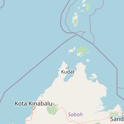
Map view of Tun Mustapha Marine Park

Use this park location map to pinpoint Tun Mustapha Marine Park in Malaysia, understand its exact geographic position, and read its mapped placement within the surrounding landscape more clearly.

Pigeon | © OpenStreetMap contributors

Location context for Tun Mustapha Marine Park

Sabah
Park atlas

Compare adjacent marine reserves and regional coastal landscapes across northern Borneo

Explore Protected Areas and Parks Near Tun Mustapha Marine Park

Browsing nearby national parks and marine reserves provides wider context for the diverse coral ecosystems and island groups found in northern Sabah. Comparing adjacent protected areas reveals broader regional patterns in coastal geography and marine conservation across the Coral Triangle.
Wildlife reservePalawan
About 127 km away#1 closest

North

Ursula Island Game Refuge and Bird Sanctuary: Geography and Protected Area Overview

An isolated wildlife reserve in the Sulu Sea, Palawan

The Ursula Island Game Refuge and Bird Sanctuary functions as a vital protected landscape, containing a rare mix of lowland rainforest and dense mangrove forests. Located offshore from the Palawan coastline, this seventeen hectare sanctuary provides essential nesting grounds and ecological refuge, illustrating the complex geography of small island conservation in the tropical Sulu Sea.

Area
0.172 km²
Established
1970
Relief
Lowland
Climate
Tropical
National parkMalaysia
About 134 km away#2 closest

Southwest

Kinabalu National Park: Mapped Boundaries and Protected Landscape Atlas

Exploring Malaysia's Natural Terrain and Park Geography

Delve into the specific protected area identity of Kinabalu National Park, situated within Malaysia. This resource details its geographic scope and mapped terrain, providing a foundation for understanding its role as a national park. Examine the park's protected landscape context, offering valuable insights for anyone exploring regional geography and conservation areas through an atlas lens.

Area
754 km²
Established
1964
IUCN
II
Visitors
611.6K annual
A pale, minimalist watercolor painting depicting a gentle, rolling landscape with green and light red washes, suggesting hills and distant foliage against a soft, bright background.
National parkSabah
About 134 km away#3 closest

Southwest

Kinabalu Park: Geographic Overview and Protected Landscape Mapping in Sabah, Malaysia

A study of vertical mountain terrain and biodiversity boundaries

Kinabalu Park stands as a defining natural entity in Sabah, Malaysia, characterized by its extreme elevation changes and concentration of rare botanical life. This atlas resource maps the park's physical geography, from its cloud-shrouded forests to its rocky summit plateaus, offering a detailed look at one of Southeast Asia's most significant protected mountain environments.

Area
754 km²
Established
1964
IUCN
II
Visitors
611.6K annual
National parkMalaysia
About 156 km away#4 closest

Southeast

Turtle Islands National Park: Marine Protected Area and Island Geography in Malaysia

Coastal landscapes and coral reef protected zones

Explore the geographic footprint of Turtle Islands National Park, a marine-focused sanctuary in Malaysia. This protected area encompasses three islands and surrounding Sulu Sea reef ecosystems, providing critical nesting habitat for marine turtles. Learn about the island-based terrain and the marine boundaries that define this protected landscape.

Area
17.4 km²
Established
1977
Relief
Lowland
Climate
Tropical
National parkSabah
About 156 km away#5 closest

Southeast

Turtle Islands National Park: Marine Geography and Protected Island Landscapes in Sabah

A Sulu Sea sanctuary for coral reefs and sea turtle nesting grounds.

Located north of Sandakan, Turtle Islands National Park is a key marine protected area defined by its island geography and extensive coral reef habitat. The park protects critical nesting beaches for green and hawksbill sea turtles, offering a focused look at how marine conservation intersects with tropical island terrain in the Sulu Sea. This geographic profile details the park's offshore environment and its connection to broader maritime conservation efforts in the region.

Area
17.4 km²
Established
1977
IUCN
II
Relief
Lowland
Wildlife reserveTawi-Tawi
About 180 km away#6 closest

Southeast

Turtle Islands Wildlife Sanctuary: Mapping the Protected Archipelago of Tawi-Tawi

Coastal landscapes, marine habitats, and island terrain

Spanning six islands at the maritime boundary of the Philippines and Malaysia, Turtle Islands Wildlife Sanctuary is defined by its extensive nesting beaches and remnant forest. This protected area integrates marine and coastal habitats, ranging from the volcanic activity on Lihiman to the forested shores of Baguan, offering a unique look at the maritime geography of the Tawi-Tawi region.

Area
2,429.67 km²
Established
1999
Nature reserveSabah
About 184 km away#7 closest

Southwest

Kota Kinabalu Wetland Centre: Protected Mangrove Landscapes in Sabah, Malaysia

An urban nature reserve and critical coastal wetland site

The Kota Kinabalu Wetland Centre stands as a preserved coastal mangrove fragment within the urban sprawl of Sabah's capital. This nature reserve provides a vital link between land and sea, offering a 1.5-kilometre boardwalk that allows for the observation of migratory bird populations and tidal mudflat ecosystems. As a designated Ramsar wetland, the site demonstrates the importance of small-scale conservation within fast-growing regional capital cities.

Area
0.24 km²
Established
1986
Relief
Lowland
Climate
Tropical
National parkSabah
About 192 km away#8 closest

Southwest

Tunku Abdul Rahman National Park: Sabah National Park Protected Landscape & Geography

Explore mapped boundaries and regional context.

Tunku Abdul Rahman National Park, designated as a national park, offers a specific focus on protected landscape exploration within Sabah. This entity details its geographic footprint and its significance as a mapped natural area. Understanding its role within the regional geography allows for a more complete exploration of Malaysia's protected lands through an atlas perspective.

Area
49 km²
Established
1974
IUCN
II
Relief
Mixed relief

Common questions about visiting, size, designation, and location context for Tun Mustapha Marine Park

Tun Mustapha Marine Park FAQs for park facts, access, geography, and protected area context

Find quick answers about Tun Mustapha Marine Park, including protected-area facts, park geography, trail and visitor context, and how the park fits into its surrounding country and regional landscape.
MoriAtlas Explorer

Continue Your Protected Areas Search Across the Global Atlas

Deepen your exploration by continuing the structured search for national parks and protected areas worldwide. Utilize the comprehensive filtering capabilities to compare different conservation landscapes and refine your understanding of global park geography. Discover more about the distribution and characteristics of protected natural areas.

Global natural geography