

Mori Atlas logo
National parkUdzungwa Mountains National Park

Discover mapped park boundaries and regional terrain within Tanzania's protected areas.

Udzungwa Mountains National Park: Protected Landscape & Geographic Context in Kilolo District

Udzungwa Mountains National Park stands as a significant protected area within Kilolo District, Tanzania. This national park offers a focused gateway for understanding its specific geographic scope, mapped boundaries, and the surrounding natural landscape. As an integral component of the regional geography, exploring this park provides detailed insight into Tanzania's protected lands and their place within a broader atlas context for discovery.

Eastern Arc Mountainstropical rainforestendemic speciesprimatesmountain foresthiking trails

Udzungwa Mountains National Park

National park

Park overview

Structured park overview, official facts, and landscape profile for Udzungwa Mountains National Park

Udzungwa Mountains National Park park facts, protected area profile, and essential visitor context
Review the core facts for Udzungwa Mountains National Park, including designation, size, terrain, visitor scale, habitats, and operating context in one park-focused overview.

About Udzungwa Mountains National Park

Udzungwa Mountains National Park occupies a unique position in Tanzania's protected area network as a relatively recent addition established in 2012. The park lies within the Udzungwa Mountains, the southernmost mountain range of the Eastern Arc Mountains system, an ancient chain of mountains that has served as a biological refuge for millions of years. The Eastern Arc Mountains are recognized as one of Africa's biodiversity hotspots, with extraordinary concentrations of endemic species across multiple taxonomic groups. Udzungwa's significance stems from its exceptional species richness and the high proportion of endemic taxa, particularly among mammals, birds, and plants. The park's interior remains largely undeveloped, with no vehicle roads penetrating its boundaries, preserving a wilderness character uncommon among Tanzania's national parks. Visitors experience the park primarily through hiking and trekking, following established trails that traverse the mountainous terrain and lead to notable features such as Sanje Falls, a 170-metre waterfall that represents one of the park's most iconic destinations.

Quick facts and research context for Udzungwa Mountains National Park

Udzungwa Mountains National Park covers 1,990 square kilometres in south-central Tanzania, straddling the Kilolo District of Iringa Region and the Kilombero District of Morogoro Region. The park was established in 2012 and is administered by the Tanzania National Parks Authority under the Ministry of Natural Resources and Tourism. The protected area contains tropical rainforest, mountain forest, miombo woodland, grassland and steppe habitats, all within a vertical elevation range of over 2,300 metres. The park is roadless and accessible only by foot, with visitors arriving primarily from the nearby town of Morogoro.

Park context

Deeper park guide and search-rich context for Udzungwa Mountains National Park

Udzungwa Mountains National Park history, landscape, wildlife, and travel context
Explore Udzungwa Mountains National Park through its history, landscape character, ecosystems, wildlife, conservation priorities, cultural context, and seasonal travel timing in a structured park guide built for atlas discovery and search intent.

Why Udzungwa Mountains National Park stands out

Udzungwa is globally significant for its extraordinary endemism, particularly among primates. The park harbours six primate species, five of which are found nowhere else on Earth. The Udzungwa red colobus and the Sanje crested mangabey are flagship endemic species that occur exclusively within this protected area. The mangabey remained undiscovered by biologists until 1979, highlighting the park's role as a repository of previously unknown biodiversity. With 2,500 plant species, of which approximately 25 percent are endemic, and over 400 bird species, the park represents one of Africa's most significant tropical biodiversity repositories.

Udzungwa Mountains National Park history and protected-area timeline

The Udzungwa Mountains National Park was officially designated as a national park in 2012, representing the culmination of conservation efforts to protect the unique biodiversity of the Udzungwa Mountains region. Prior to national park status, the area existed as a forest reserve, reflecting its long-standing recognition as an ecologically significant area requiring protection. The formal establishment as a national park elevated the protection status and brought the area under the management of the Tanzania National Parks Authority, aligning it with the country's premier protected area network. The park's relatively recent creation means it represents a modern addition to Tanzania's conservation estate, benefiting from contemporary conservation science and management approaches.

Udzungwa Mountains National Park landscape and geographic character

The physical landscape of Udzungwa Mountains National Park is defined by its mountainous terrain and the dramatic altitudinal gradient that spans over 2,300 metres. The park encompasses the southern reaches of the Udzungwa Mountains, which form part of the Eastern Arc Mountains, a range characterized by ancient, heavily weathered peaks and steep-sided valleys. The terrain rises from lower elevations around 250 metres above sea level to the summit of Lohomero at 2,576 metres, creating diverse environmental conditions across a relatively short horizontal distance. The landscape includes tropical rainforest in the lower elevations, transitioning through mountain forest zones and into miombo woodland, grassland and steppe habitats at higher elevations. The park's topography includes prominent waterfalls, most notably Sanje Falls, which drops approximately 170 metres and forms a dramatic feature within the mountainous environment.

Udzungwa Mountains National Park ecosystems, habitats, and plant life

The ecological diversity of Udzungwa Mountains National Park reflects the complex interplay of elevation, climate, and the long evolutionary isolation of the Eastern Arc Mountains. The park contains an exceptional mosaic of habitats, including tropical rainforest at lower elevations, montane forest zones, miombo woodland characterized by Brachystegia trees, grasslands, and steppe environments. This habitat diversity supports remarkable plant richness, with approximately 2,500 species documented within the park boundaries, of which around 25 percent are endemic to the region. The combination of high rainfall in the lower elevations and the montane environment creates conditions favourable for lush forest development and extraordinary botanical diversity. The park's position at the southern end of the Eastern Arc Mountains places it at a biogeographic crossroads, receiving influences from multiple ecological zones and contributing to its species richness.

Udzungwa Mountains National Park wildlife and species highlights

The mammalian fauna of Udzungwa Mountains National Park is distinguished by its extraordinary concentration of endemic primates. Six primate species have been recorded within the park, a remarkable number for an African protected area of this size. Five of these primate species are endemic to the Udzungwa Mountains, meaning they are found nowhere else in the world. The Udzungwa red colobus represents one of the most distinctive endemic primates, while the Sanje crested mangabey remains the most recently described primate species in the region, not formally identified by scientists until 1979. Beyond primates, the park supports over 400 bird species, making it an important destination for ornithological exploration. The invertebrate fauna includes endemic species such as a chameleon formally described from the park in 2009, demonstrating that new species discoveries continue to emerge from this biodiversity-rich environment.

Udzungwa Mountains National Park conservation status and protection priorities

Udzungwa Mountains National Park represents a critical conservation priority within Africa due to its extraordinary biodiversity and high concentration of endemic species. The park protects significant populations of species found nowhere else on Earth, including two primate species that occur exclusively within its boundaries. The 25 percent endemism rate among plant species highlights the global significance of the Udzungwa Mountains as an evolutionary reservoir. The park's designation as a national park in 2012 reflected Tanzania's commitment to preserving this exceptional biological heritage. The protection of the Udzungwa Mountains also contributes to the conservation of the broader Eastern Arc Mountains ecosystem, which is recognized internationally as a biodiversity hotspot requiring sustained conservation attention.

Udzungwa Mountains National Park cultural meaning and human context

The Udzungwa Mountains exist within a region inhabited by local communities whose relationship with the landscape predates formal protected area designation. The park is located in an area of Tanzania where rural communities practice agriculture and maintain traditional land-use patterns. The nearby village of Mang'ula serves as a base for some visitors accessing the park, and local guesthouses provide accommodation options for budget-conscious travellers. The park's name derives from the Swahili term for the mountain range, reflecting the indigenous linguistic heritage of the region.

Top sights and standout views in Udzungwa Mountains National Park

The Sanje Falls trail stands as the park's most popular visitor experience, offering approximately four hours of hiking through forest terrain to reach a stunning 170-metre waterfall where visitors can swim in the plunge pools below. The trail system ranges from the accessible one-hour Sonjo trek to the demanding six-day Lumemo Trail for experienced hikers seeking extended wilderness immersion. The park's roadless character ensures that exploration occurs entirely on foot, preserving a wilderness experience increasingly rare in Tanzania's national parks. Endemic primate populations, particularly the Udzungwa red colobus and Sanje crested mangabey, represent living highlights that attract researchers and wildlife enthusiasts seeking encounters with species found nowhere else on Earth.

Best time to visit Udzungwa Mountains National Park

The optimal period for visiting Udzungwa Mountains National Park coincides with the dry season, typically from June through October, when trail conditions are most favourable for hiking and wildlife viewing opportunities are enhanced as animals concentrate around remaining water sources. The wet season from November through May brings higher rainfall that can make trails more challenging and slippery, though the landscape displays increased lushness and waterfalls often flow with greater volume. The park's mountainous character means that weather patterns can vary with elevation, and visitors should be prepared for variable conditions regardless of season.

Park location guide

Geography guide, regional context, and park location map for Udzungwa Mountains National Park

Udzungwa Mountains National Park park geography, regions, and map view in Tanzania
Understand where Udzungwa Mountains National Park sits in Tanzania through a broader geographic reading of the surrounding landscape, nearby location context, and its mapped position within the national park landscape.

How Udzungwa Mountains National Park fits into Tanzania

Tanzania, officially the United Republic of Tanzania, is a presidential republic in East Africa within the African Great Lakes region. It was formed in 1964 through the unification of Tanganyika and Zanzibar. The country is known for its diverse wildlife, national parks including Serengeti and Ngorongoro, and significant archaeological sites with important hominid fossils.

Wider geography shaping Udzungwa Mountains National Park in Tanzania

Tanzania is located in East Africa within the African Great Lakes region. It is bordered by Uganda to the northwest, Kenya to the northeast, the Indian Ocean to the east, Mozambique and Malawi to the south, Zambia to the southwest, and Rwanda, Burundi, and the Democratic Republic of the Congo to the west. The country includes the mainland and the Zanzibar Archipelago.

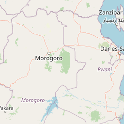
Map view of Udzungwa Mountains National Park

Use this park location map to pinpoint Udzungwa Mountains National Park in Tanzania, understand its exact geographic position, and read its mapped placement within the surrounding landscape more clearly.

Pigeon | © OpenStreetMap contributors

Location context for Udzungwa Mountains National Park

Iringa RegionKilolo DistrictMorogoro Region
Park atlas

Trace the Regional Geography and Explore Protected Areas Across the Eastern Arc Mountains

Discover Other National Parks Near Udzungwa Mountains National Park
After exploring Udzungwa Mountains National Park's unique biodiversity, continue your discovery by comparing other protected areas within the Eastern Arc Mountains and surrounding Tanzanian landscapes. Browse the mapped geography to understand regional conservation patterns, identify adjacent park ecosystems, and trace the spread of similar mountain forest habitats.
Watercolor illustration of a river flowing through a grassy field with scattered trees and distant hills under a soft sky
National parkMorogoro Region

Mikumi National Park: East African Savannah Protected Landscape in Morogoro Region

Mapped boundaries and regional geography for a key Tanzanian national park.

Mikumi National Park, a vital protected area in Tanzania's Morogoro Region, offers a classic savannah experience with iconic baobab trees and diverse wildlife populations. This national park is distinguished by its extensive alluvial plains, shaped by the Mkata River basin, and its significant role as a wilderness corridor connecting with the larger Selous Game Reserve. The park's terrain includes Malundwe Mountain and views of the Uluguru Mountains, providing a rich geographic backdrop for understanding East African protected lands and their atlas-style distribution.

Area
3,230 km²
Established
1964
IUCN
II
Visitors
41.7K annual
National parkTanzania

Nyerere National Park: Tanzania's Immense Protected Area and Rufiji River Landscape

Explore the savanna and river delta geography of this national park.

Nyerere National Park represents one of Tanzania's most significant protected areas, sprawling across southeastern regions and offering a glimpse into largely untouched wilderness. The park's identity is deeply intertwined with the Rufiji River and its expansive delta, home to one of the world's largest mangrove forest systems. As a national park, its vastness and diverse terrain provide critical habitat, making it a key point for understanding protected land distribution and regional landscape context within Tanzania.

Area
30,893 km²
Established
2019
IUCN
II
Relief
Mixed relief
National parkTanzania

Ruaha National Park: Tanzania National Park, Protected Landscape and Geographic Atlas

Mapped boundaries and regional landscape context for Ruaha National Park.

Explore the protected landscape of Ruaha National Park in Tanzania. This page provides detailed mapping of its boundaries and offers insights into its geographic setting. Understand its significance as a national park within the atlas of protected areas, focusing on its natural terrain and regional context without travel logistics.

Area
20,226 km²
Established
1964
IUCN
II
Visitors
21.3K annual
National parkTanga Region

Saadani National Park: Protected Landscape and Geographic Context in Tanga Region

Explore the mapped boundaries and regional geography of this Tanzanian national park.

Saadani National Park represents a distinct protected landscape within the northern Tanzanian coast, specifically situated in the Tanga Region. This entry offers a focused exploration of the park's geographic features, its mapped protected area boundaries, and its intrinsic connection to the regional natural terrain. Delve into the atlas-level details that define Saadani National Park, providing crucial context for understanding its ecological and geographic significance.

Area
1,062 km²
Established
2005
IUCN
II
Visitors
15.4K annual
National parkNjombe Region

Kitulo National Park: National Park within Njombe Region's Geographic Atlas

Mapped protected area boundaries and regional landscape context.

Kitulo National Park represents a distinct national park within the geographic atlas of Tanzania's Njombe Region. This page offers a focused exploration of its protected landscape identity, highlighting its mapped boundaries and contributing to a broader understanding of regional geography. It is designed for users seeking detailed, atlas-centric information about Kitulo National Park's specific natural landscape and its position within the surrounding terrain.

Area
413 km²
Established
2005
IUCN
II
Visitors
409 annual
National parkSouth Zanzibar Region

Jozani Chwaka Bay National Park: A Protected Landscape within the South Zanzibar Region

National Park geography and mapped protected area.

Delve into Jozani Chwaka Bay National Park, a key protected area situated in Tanzania's South Zanzibar Region. This canonical page offers a structured view of the park's geography, its mapped boundaries, and its role as a national park. Understand its landscape context and its significance for detailed geographic discovery and atlas-based exploration.

Area
50 km²
Established
2004
IUCN
II
Climate
Tropical
National parkTanzania

Mkomazi National Park: Tanzania's Vast Protected Savanna Landscape and Wildlife Geography

Explore its mapped terrain and conservation significance within East Africa.

Mkomazi National Park is a critical protected landscape in Tanzania, spanning over 3,200 square kilometers of classic East African semi-arid savanna woodland. This national park offers a unique atlas-style view into conservation success, particularly for its black rhinoceros sanctuary and African wild dog programs. Its landscape is characterized by rolling terrain and Acacia-Commiphora vegetation, forming a vital transboundary conservation area with Kenya that supports significant wildlife migration corridors and provides a distinct geographic context within the broader regional atlas.

Area
3,234 km²
Established
2006
IUCN
II
Visitors
1.6K annual
National parkMalawi

Nyika National Park: Malawi National Park Atlas Exploration and Protected Landscape

Discover geographic context and mapped boundaries of this protected area.

Nyika National Park serves as a core entry for understanding Malawi's protected areas and natural landscapes through an atlas lens. Explore the park's designation as a national park, its geographic positioning within Malawi, and the mapped context that defines its protected status. This detail page provides a foundational view for appreciating the park's landscape and its contribution to the regional protected lands overview.

Area
3,134 km²
Established
1966
IUCN
II
Relief
Highland

Common questions about visiting, size, designation, and location context for Udzungwa Mountains National Park

Udzungwa Mountains National Park FAQs for park facts, access, geography, and protected area context
Find quick answers about Udzungwa Mountains National Park, including protected-area facts, park geography, trail and visitor context, and how the park fits into its surrounding country and regional landscape.
MoriAtlas Explorer

Continue Your Protected Areas Search Across the Global Atlas

Deepen your exploration by continuing the structured search for national parks and protected areas worldwide. Utilize the comprehensive filtering capabilities to compare different conservation landscapes and refine your understanding of global park geography. Discover more about the distribution and characteristics of protected natural areas.

Global natural geography
