
Mori Atlas logo
Natural monumentUhlířský vrch

Mapping the ecological significance and terrain of a key conservation site in the South Bohemian highlands.

Uhlířský vrch Natural Monument: A Detailed Geographic Atlas of Protected Mountain Forest Landscapes

Uhlířský vrch functions as a critical protected natural monument, safeguarding mountain mixed forest and scree woodland along the northern slopes of a Šumava foothill in the Jihočeský kraj region. This atlas entry details the compact yet complex topography of the site, which transitions through various elevations and rocky debris zones. Users can investigate its specific boundary context and its role as a managed habitat within the broader Vyšebrodsko natural park landscape.

natural monumentprotected forestmountain forestscree woodlandmontane habitathabitat and species management
Digital illustration of a scenic mountain landscape with a central waterfall, a flowing stream, evergreen trees, and fern foliage in the foreground.

Uhlířský vrch

Natural monument

Park overview

Structured park overview, official facts, and landscape profile for Uhlířský vrch

Uhlířský vrch park facts, protected area profile, and essential visitor context

Review the core facts for Uhlířský vrch, including designation, size, terrain, visitor scale, habitats, and operating context in one park-focused overview.

About Uhlířský vrch

Uhlířský vrch sits in the deep forested belt of South Bohemia, close to the forested borderlands with Austria along the Šumava. Although only about 16 hectares in extent, the natural monument represents an ecologically valuable fragment of the regional forest landscape. The protected land lies on the north-facing slopes of a hill of the same name, between 800 and 925 meters above sea level, where cooler and moister microclimates support a different forest type than the surrounding valleys.

The site is closely tied to the Vyšebrodsko natural park, which connects several smaller protected features around the upper Vltava basin near Loučovice and Vyšší Brod. Within this broader area, Uhlířský vrch stands out for combining slope position, elevation, and rocky debris (scree) that together create conditions for diverse woodland structure. The forest here includes elements typical of montane Šumava habitats, with mixed species composition and natural regeneration processes typical of less intensively managed woodland.

Administratively, the site is registered as code 1554 in the Czech nature conservation register and is recognized at the international level as an IUCN Category IV protected area. This category corresponds to habitat and species management areas, fitting a small, targeted conservation site designed to safeguard a specific forest type rather than an entire ecosystem. Its designation in the early 1990s came during a broader wave of smaller, habitat-focused nature protection in newly post-socialist Czechia, where many such sites were formalized after 1989.

Quick facts and research context for Uhlířský vrch

Uhlířský vrch is a Czech natural monument (přírodní památka) in the Český Krumlov District of the South Bohemian Region. The site lies on the northern slope of the 925 m Uhlířský vrch hill, within the Šumava mountain range and the Trojmezenská hornatina subdivision. It was officially declared in 1992 by the District Office in Český Krumlov and covers roughly 16 hectares between 800 and 925 m in elevation. The protected area sits inside the broader Vyšebrodsko natural park and is nationally catalogued under nature conservation code 1554.

Protection and recognition

Examine the documented conservation framework and international recognition data

Uhlířský vrch Protection Status and Terrestrial Conservation Scope

Uhlířský vrch maintains a defined terrestrial protection scope within the regional conservation network. Structured records detail the official designation history and international recognition sources associated with this protected natural area.

Protection details

Protection scope
Terrestrial
Transboundary protection
No
Park context

Deeper park guide and search-rich context for Uhlířský vrch

Uhlířský vrch history, landscape, wildlife, and travel context

Explore Uhlířský vrch through its history, landscape character, ecosystems, wildlife, conservation priorities, cultural context, and seasonal travel timing in a structured park guide built for atlas discovery and search intent.

Why Uhlířský vrch stands out

The protected area is best known for preserving a remnant of mountain mixed forest and scree woodland on the northern flank of a Šumava foothill near the Lipno region. Its elevation range, position within the Trojmezenská hornatina, and integration into the Vyšebrodsko natural park give the site its character. Rather than dramatic scenery, the monument's significance lies in the survival of old-growth style mountain forest on rocky, unstable slopes.
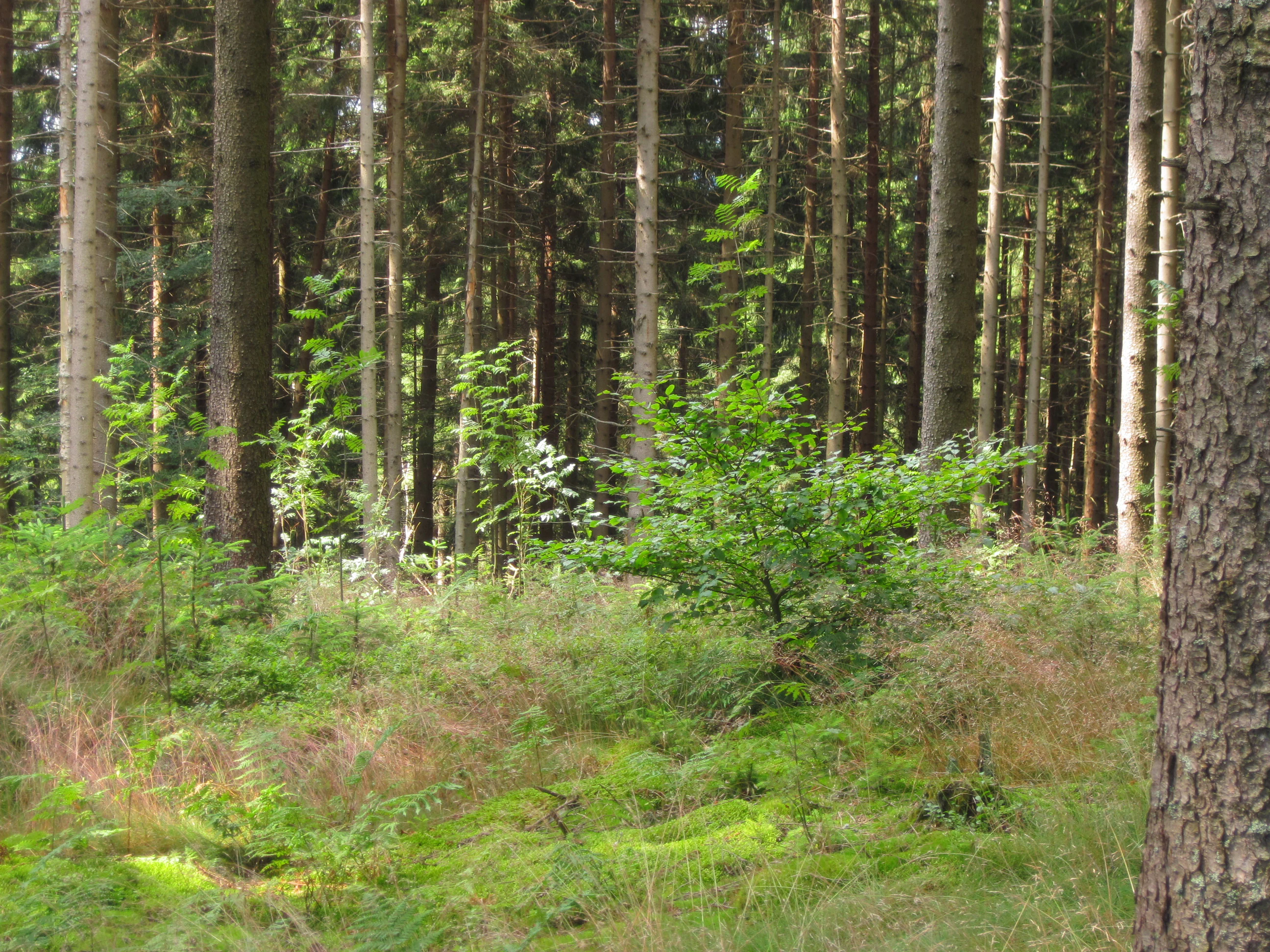
A view into a dense mixed forest with tall vertical tree trunks and a forest floor covered in moss, ferns, and young saplings.
Mixed forest landscape within the Uhlířský vrch natural monument.

Uhlířský vrch history and protected-area timeline

Uhlířský vrch was officially declared a protected natural monument on 27 May 1992 by the District Office of Český Krumlov. Its establishment was part of a Czech wave of small-scale nature protection sites formalised in the early post-socialist period, when previously recognized ecologically valuable localities gained clearer official status.

The site's protected designation focuses specifically on the survival of mountain mixed forest and scree woodland on the northern slope of the hill. The hill itself, standing at 925 meters, is part of the Šumava system, and the monument thus forms one element within a wider landscape of overlapping protected areas, including the Vyšebrodsko natural park that surrounds it. Beyond its declaration date, the publicly documented history of the site centers on this conservation recognition rather than on any broader cultural or economic history.

Uhlířský vrch landscape and geographic character

The landscape of Uhlířský vrch is shaped by its position in the Trojmezenská hornatina, specifically the Lučská hornatina subunit and the Loučovická hornatina sub-unit. The protected area occupies the northern slope of the hill, where the terrain transitions from smoother upper ridges down toward the valley near Loučovice. Elevations within the protected boundary range from 800 meters at the lower edge to the 925 m summit, giving the site noticeable vertical relief over a small footprint.

Geomorphologically, the area combines hilltop ridges with steeper slope sections and rocky debris accumulations at the base of the slope. These scree zones, together with the cool shaded northern exposure, create a mosaic of substrates and microclimates across a compact area. The result is a fragmentary but physically diverse setting that contrasts with the more uniform land cover of surrounding valley and ridge land, reflecting the typical terrain transitions between Šumava highlands and the broader South Bohemian landscape.

Uhlířský vrch ecosystems, habitats, and plant life

The primary subject of ecological protection at Uhlířský vrch is the remaining mountain mixed forest and scree woodland on the northern slope of the hill. This forest type is characteristic of upper-elevation Šumava habitats where tree species composition mixes broadleaf and conifer elements, depending on slope, moisture, and substrate.

The presence of scree woodland is particularly significant, as such habitats develop on unstable rocky debris where natural disturbance allows specialized tree regeneration patterns and understory diversity. Cooler microclimates driven by the north-facing aspect extend the ecological gradient within the protected area, supporting forest communities that differ from warmer, more uniform lowland forest cover elsewhere in the region.

Although small, the site preserves ecological continuity in a region with a long history of forestry, providing refuge for forest-associated species and habitat structures that depend on older, less disturbed woodland. Its inclusion within the broader Vyšebrodsko natural park further integrates it into a wider network of habitat features in the upper Vltava basin landscape.

Uhlířský vrch conservation status and protection priorities

Uhlířský vrch holds conservation value primarily as a representative remnant of mountain mixed forest and scree woodland in the South Bohemian section of the Šumava mountain system. The site was designated specifically to maintain this forest type under formal protection, recognizing that such habitats have been reduced elsewhere through forestry and land use change.

By national Czech classification, the area is registered as code 1554 in the nature conservation registry. At the international level, it is included in the IUCN network as a Category IV protected area, a designation given to sites whose main purpose is the protection of particular species or habitats through active management rather than strict non-intervention. This category suits the site's role as a focused habitat refuge within a heavily forested, partially managed regional landscape.

The monument's integration into the Vyšebrodsko natural park strengthens its conservation role by linking it with surrounding protected features in the upper Vltava basin. Together, these overlapping designations contribute to a layered protection regime that maintains forest ecological continuity near the Šumava border area.

Top sights and standout views in Uhlířský vrch

Uhlířský vrch's main highlight is its preserved mountain mixed forest and scree woodland on a north-facing Šumava foothill between 800 and 925 meters elevation. The site's compact size hides real ecological diversity, with slope, rocky debris, and microclimate variation supporting a distinctive forest type.

Another notable highlight is its integration into the Vyšebrodsko natural park and the broader Šumava protected landscape, situating the monument within a layered conservation system in South Bohemia. The 1992 designation, SNHM code 1554, and IUCN Category IV status together give the site clear institutional identity as a habitat-focused protected area in the Czech nature conservation network.

Monthly climate preview

Measured monthly weather patterns and representative climatology for Uhlířský vrch

Uhlířský vrch Climate Normals, Long-Term Temperature and Precipitation Rhythm

Uhlířský vrch records long-term temperature swings from sub-zero winter minimums to warm summer highs alongside measured monthly precipitation rates. Detailed multi-year climate profiles unpack complete twelve-month weather patterns across representative coordinate elevations.
Annual mean7 °C
-3 °C18 °C
Jan-3°
Feb-2°
Mar
Apr
May12°
Jun16°
Jul18°
Aug18°
Sep13°
Oct
Nov
Dec-2°
Warmest month
July

17.8 °C

Coolest month
January

-3.3 °C

Wettest month
July

3.6 mm/day

Driest month
February

1.6 mm/day

Park location guide

Geography guide, regional context, and park location map for Uhlířský vrch

Uhlířský vrch park geography, regions, and map view in Czechia

Understand where Uhlířský vrch sits in Czechia through a broader geographic reading of the surrounding landscape, nearby location context, and its mapped position within the national park landscape.

How Uhlířský vrch fits into Czechia

Czech Republic is a landlocked Central European country with a population of approximately 10.9 million people. The nation was established as an independent state on January 1, 1993, following the dissolution of Czechoslovakia. Its capital and largest city is Prague, with other major urban centers including Brno, Ostrava, Plzeň, and Liberec.

Wider geography shaping Uhlířský vrch in Czechia

The Czech Republic is a landlocked country in Central Europe. It is bordered by Germany to the west, Austria to the south, Poland to the northeast, and Slovakia to the southeast. The landscape is predominantly hilly, with the territory covering 78,871 square kilometers.

Map view of Uhlířský vrch

Use this park location map to pinpoint Uhlířský vrch in Czechia, understand its exact geographic position, and read its mapped placement within the surrounding landscape more clearly.

Pigeon | © OpenStreetMap contributors

Location context for Uhlířský vrch

Jihočeský kraj

Visualizing the mountain mixed forest and scree woodland habitats of the Šumava foothills

Uhlířský vrch Photos and Protected Forest Landscape Imagery

Visual records capture the steep northern slopes, rocky debris fields, and preserved montane tree cover defining the terrain of Uhlířský vrch. Examining these habitat views clarifies the protected area character and geomorphological diversity found across the South Bohemian highlands.

A view into a dense mixed forest with tall vertical tree trunks and a forest floor covered in moss, ferns, and young saplings.

Park atlas

Discover related national parks and regional highland habitats across South Bohemia

Explore Parks Near Uhlířský Vrch and Surrounding Protected Landscapes

Compare Uhlířský vrch with other protected areas located throughout the surrounding Šumava highland region. Examining adjacent natural monuments provides broader geographic context for montane forest conservation and terrain variation.
Nature reserveJihočeský kraj
About 1.3 km away#1 closest

West

Rašeliniště Kapličky Nature Reserve: Mapped Protected Landscapes in South Bohemia

High-altitude peatland and bog pine forest geography

Rašeliniště Kapličky encompasses 73 hectares of transitional peatland in the Bohemian Forest foothills. The reserve is defined by its deep granite-based peat deposits, rare bog-pine hybrid populations, and the drainage patterns of the Lipový potok stream. This protected area serves as an essential reference for understanding upland wetland ecology and the post-industrial landscape history of the South Bohemian borderlands.

Area
1.27 km²
Established
1992
IUCN
IV
Relief
Upland
Nature reserveJihočeský kraj
About 16 km away#2 closest

Northwest

Velké bahno Nature Reserve: Protected Wetland and Mire Geography in the Šumava Foothills

Essential conservation habitat within the Jihočeský kraj region of the Czech Republic

Velké bahno stands as a compact but vital nature reserve featuring spruce-alder swamps, wooded peatlands, and boggy clearings. Its position within the Šumava Protected Landscape Area highlights a concentration of sensitive mire habitats, protected flora, and rare species adapted to the wet, undulating paragneiss terrain of the Bohemian Forest foreland.

Area
0.915 km²
Established
1992
IUCN
IV
Relief
Upland
A horizontal watercolor painting depicting a soft, atmospheric landscape with grassy foreground vegetation, a treeline, and distant rolling hills against a pale sky.
Nature reserveJihočeský kraj
About 17 km away#3 closest

Northwest

Rašeliniště Borková Nature Reserve: Protected Peatlands in the Jihočeský kraj

Mapped wetlands and relict mire ecosystems of southern Bohemia

Located along the Lipno reservoir, Rašeliniště Borková preserves a essential fragment of the original Vltavická brázda valley landscape. The area maps a compressed, multi-zoned wetland habitat that ranges from nutrient-poor sedge mires to stable bog pine woodland, providing a necessary refuge for mire-dependent invertebrates and breeding waterbirds.

Area
0.487 km²
Established
1995
IUCN
IV
Relief
Upland
Watercolor illustration of a river flowing through a forested landscape with rolling hills in the background
National parkSouth Bohemian Region
About 23 km away#4 closest

Northwest

Šumava National Park: Czech Republic's Premier Forested National Park and Protected Landscape

Explore the unique glacial lakes, peat bogs, and regional geography.

Šumava National Park, situated in the South Bohemian Region of the Czech Republic, is the nation's largest protected area and a vital component of Central Europe's forest ecosystems. This entry details its expansive terrain, highlighting the significant peat bog complexes and ancient glacial lakes that define its unique landscape. Discover the park's geographic context, mapped boundaries, and its importance as a protected natural asset within the broader regional atlas.

Area
680.64 km²
Established
1991
IUCN
II
Visitors
2M annual
Nature reserveJihočeský kraj
About 25 km away#5 closest

Northeast

Velký Hodonický rybník Nature Reserve: Regional Geography and Protected Wetland Atlas

Mapped aquatic habitats in the South Bohemian foothills

Situated in the Novohradské podhůří, Velký Hodonický rybník is a protected nature reserve defined by its shallow fishpond basin and specialized wetland flora. This site acts as a key element of the Natura 2000 network, preserving rare aquatic vegetation and amphibian populations within a characteristic South Bohemian landscape. The area offers a detailed view into the intersection of historical agricultural land use and contemporary environmental preservation.

Area
0.027 km²
Established
2023
IUCN
III
Watercolor illustration of a soft, rolling landscape with purple hills in the distance and pale green and pink vegetation in the foreground.
Natural monumentJihočeský kraj
About 26 km away#6 closest

North

Meandry Chvalšinského potoka Natural Monument: Mapped River Geography and Valley Terrain

Protected riparian habitat in the South Bohemian landscape

This natural monument protects a remarkably intact stretch of the Chvalšinský potok, where natural meanders, cut banks, and point bars create a living laboratory of fluvial geography. Beyond the stream itself, the site encompasses moist thistle and sedge meadows, offering a clear view into the traditional wetland ecology of the region. As a protected enclave, it maintains essential hydrological integrity within the broader landscape of the Czech countryside.

Area
0.048 km²
Established
2001
IUCN
IV
Relief
Lowland
Natural monumentJihočeský kraj
About 26 km away#7 closest

North

Výří vrch Natural Monument: Regional Geography and Limestone Habitat Mapping

Protected limestone terrain in Jihočeský kraj

Výří vrch preserves a striking limestone inselberg that rises above the regional upland forests of the Czech Republic. The site provides a critical study in how exposed calcareous geology and warm, dry microclimates support a dense, specialized collection of steppe-like flora and invertebrate species within a broader forest-dominated landscape.

Area
0.129 km²
Established
2010
IUCN
IV
Relief
Upland
A watercolor painting of a rolling mountain landscape with forests, depicted in varying tones of green, orange, and purple, set against a white background.
Nature reserveJihočeský kraj
About 33 km away#8 closest

North

Ptačí stěna Nature Reserve: Mapped Geographic Profile of South Bohemian Protected Forests

Granulite cliff landforms and submontane beech forest mapping.

Ptačí stěna Nature Reserve occupies a steep southwestern slope in the Blanský les, defined by a linear granulite frost-riven cliff and a vast talus field of boulders up to three meters across. This protected area showcases the interplay between mature 150-year-old beech woodlands and rugged, cool microhabitats that support unique species. The site serves as a vital example of layered forest and rock conservation in South Bohemia.

Area
0.205 km²
Established
1996
IUCN
IV
Relief
Mountain

Common questions about visiting, size, designation, and location context for Uhlířský vrch

Uhlířský vrch FAQs for park facts, access, geography, and protected area context

Find quick answers about Uhlířský vrch, including protected-area facts, park geography, trail and visitor context, and how the park fits into its surrounding country and regional landscape.
MoriAtlas Explorer

Continue Your Protected Areas Search Across the Global Atlas

Deepen your exploration by continuing the structured search for national parks and protected areas worldwide. Utilize the comprehensive filtering capabilities to compare different conservation landscapes and refine your understanding of global park geography. Discover more about the distribution and characteristics of protected natural areas.

Global natural geography