

Mori Atlas logo
Protected landscapeUnteres Körschtal

A preserved green corridor featuring river valleys, wooded slopes, and plateau transitions in central Germany

Unteres Körschtal: Mapping the Protected Landscape and River Valley Geography of Baden-Württemberg

(Landschaftsschutzgebiet „Unteres Körschtal")

Unteres Körschtal serves as a critical protected landscape within the Filder natural region, tracing the lower river valley from Denkendorf to Deizisau. This area acts as a geographic transition zone between the elevated Filder plateau and the Neckar river corridor, safeguarding diverse natural structures including meadow floors and woodland slopes. MoriAtlas provides the mapped boundary and terrain context for this significant example of peri-urban conservation in southwestern Germany.

landscape protection areariver valleySwabian Keuper-Lias LandFilderNeckar valleyKörsch valley

Unteres Körschtal

Protected landscape

Park overview

Structured park overview, official facts, and landscape profile for Unteres Körschtal

Unteres Körschtal park facts, protected area profile, and essential visitor context

Review the core facts for Unteres Körschtal, including designation, size, terrain, visitor scale, habitats, and operating context in one park-focused overview.

About Unteres Körschtal

Unteres Körschtal is one of many landscape protection areas, or Landschaftsschutzgebiete, that shape the green periphery of the Stuttgart metropolitan region. Located in the district of Esslingen, it occupies the lower portion of the Körsch valley as the river approaches the Neckar, and it extends into a section of the Neckar valley itself. The protected zone runs between Denkendorf in the southwest and Deizisau in the northeast, taking in parts of Esslingen am Neckar and Köngen as well.

Geographically, the area belongs to the Filder natural region, itself a subunit of the Swabian Keuper-Lias Land, a major natural region defined by the underlying sedimentary geology of central Baden-Württemberg. This setting gives the protected area a layered landscape, with the broad, agriculturally shaped Filder plateau above and the more incised, partly wooded valley of the Körsch and Neckar below. The contrast between open plateau, wooded slopes, and valley floodplain creates a varied protected landscape within a relatively compact area.

Beyond its ecological value, Unteres Körschtal serves a clear regional function. Because it lies on the southeastern margin of the densely populated Stuttgart conurbation, it has been formally designated as an ecological balancing area and as a local recreation space. The 1978 protective ordinance preserves not only the valley itself, but also the surrounding slopes and adjacent land, recognizing that the landscape character depends on the interaction between valley, slope, and plateau habitats. Its long-standing protected status and its position relative to one of Germany's largest urban regions make it a benchmark case for landscape-scale conservation at the edge of a major city.

Quick facts and research context for Unteres Körschtal

Unteres Körschtal is a Landschaftsschutzgebiet, classified under IUCN Category V as a Protected Landscape/Seascape. Established on 19 October 1978 under protective area number 1.16.014, it spans roughly 4,729 hectares across the municipalities of Deizisau, Denkendorf, Esslingen am Neckar, and Köngen. The area is administered by the district of Esslingen and lies within the Filder natural region (designated 106) of the Swabian Keuper-Lias Land major natural unit. Its World Database on Protected Areas ID is 325343.

Protection and recognition

Examine the documented conservation framework and official designation history for Unteres Körschtal.

Unteres Körschtal Protection Status and International Recognition Records

Unteres Körschtal maintains documented protection records detailing official conservation status and administrative designation metrics. Archival datasets outline verified management frameworks and regional recognition criteria without assuming regulatory outcomes.

Protection details

WDPA ID
325343
Park context

Deeper park guide and search-rich context for Unteres Körschtal

Unteres Körschtal history, landscape, wildlife, and travel context

Explore Unteres Körschtal through its history, landscape character, ecosystems, wildlife, conservation priorities, cultural context, and seasonal travel timing in a structured park guide built for atlas discovery and search intent.

Why Unteres Körschtal stands out

The area is best known for safeguarding the natural structure of the lower Körsch valley, including its valley floor, slopes, and surroundings, in a heavily populated part of Baden-Württemberg. It serves as a continuous green corridor between the Filder plateau and the Neckar river valley, combining woodland, meadow, and slope habitats within a single protected framework. Its proximity to Stuttgart and its long-standing protected status since 1978 make it a textbook example of peri-urban landscape conservation in Germany.
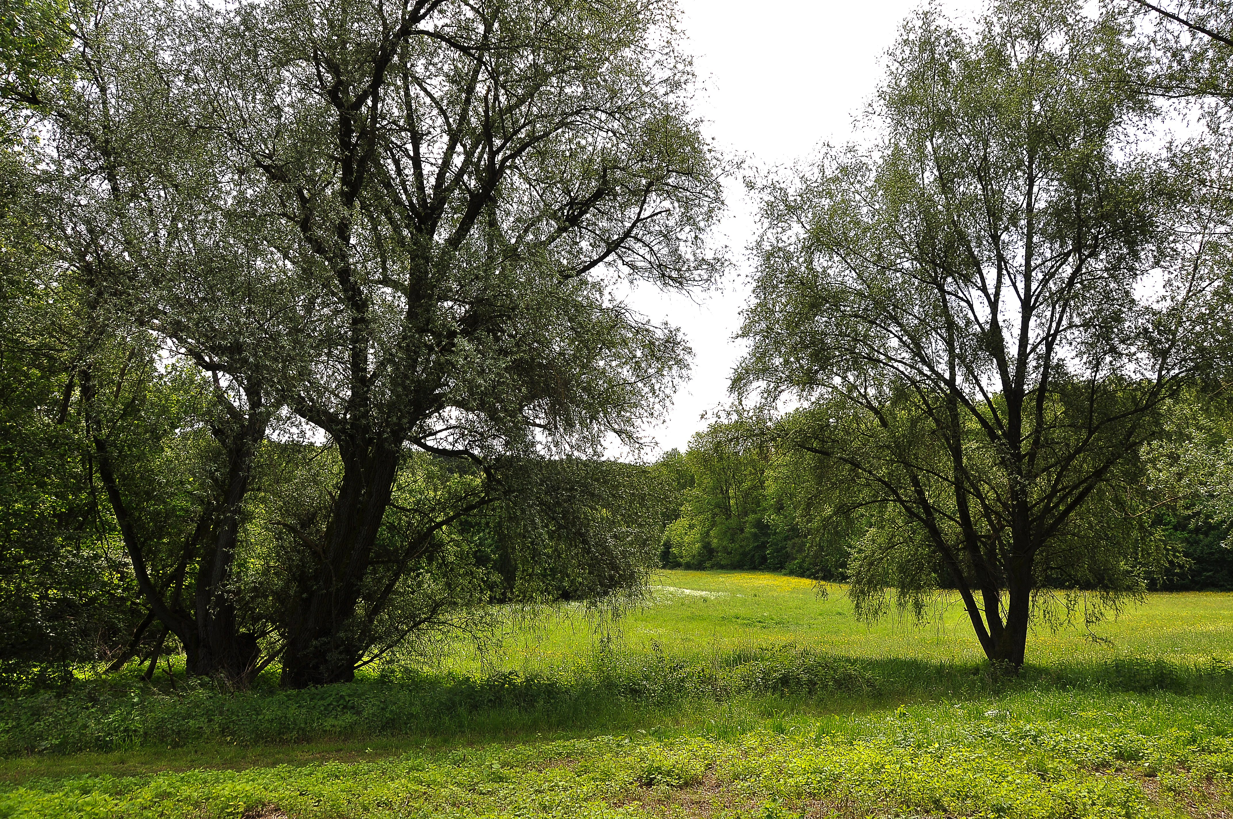
Körschtal landscape
The landscape view adjacent to the German Institutes for Textile and Fiber Research Denkendorf

Unteres Körschtal history and protected-area timeline

Unteres Körschtal was formally placed under protection on 19 October 1978 as a Landschaftsschutzgebiet under the protective area number 1.16.014. The decision was made within the framework of Baden-Württemberg's long-standing tradition of designating peri-urban landscape protection areas around Stuttgart and other growing urban centers.

According to the underlying protective ordinance, the essential purpose of the designation is to preserve the lower Körsch valley in its natural structure and diversity, together with its slopes and surroundings, as an ecological balancing area and recreation space on the southeastern edge of the Stuttgart metropolitan area. Since its establishment, the area has remained under the administration of the district of Esslingen and continues to function as one of the regional green-space pillars of the district's protected-area network. The area is documented in the 1985 reference work Landschaftsschutzgebiete im Kreis Esslingen, published by the Landesanstalt für Umweltschutz Baden-Württemberg.

Unteres Körschtal landscape and geographic character

The landscape of Unteres Körschtal is defined by the valley of the Körsch river as it descends from the Filder plateau toward the Neckar. The protected area spans both this valley and a portion of the Neckar valley itself, producing a layered topography of plateau edge, wooded slopes, valley floor, and river corridor.

The Filder plateau above the protected area is one of the most distinctive natural regions of central Baden-Württemberg: a broad, gently rolling highland formed on Keuper and Lias sedimentary rocks, traditionally shaped by agriculture and settlement. Below this plateau edge, the Körsch has carved a valley of mixed woodland, meadow, and slope habitats, while the northern part of the area opens out into the broader Neckar valley. Sloping woodland, valley meadows, and small floodplain features combine to give the protected area a transitional character between open highland and active river valley.

Unteres Körschtal ecosystems, habitats, and plant life

Because Unteres Körschtal sits on the Filder plateau and drops into two river valleys, it stitches together several habitat types within a single protected framework. The plateau edge supports agricultural land and settlement-influenced open habitats, while the valley slopes preserve mixed woodland, and the valley floor retains meadow and floodplain vegetation along the Körsch and Neckar.

This ecological gradient is precisely what the 1978 ordinance sought to protect. Rather than preserving a single habitat, the landscape protection designation keeps the natural structure and diversity of the lower Körsch valley intact, including the transition between slope, valley floor, and surrounding land. The result is a habitat mosaic typical of Swabian river-valley landscapes: a combination of forest on steeper slopes, semi-open grasslands in the valley, and riparian conditions along the watercourses themselves.

Unteres Körschtal conservation status and protection priorities

Unteres Körschtal is classified under IUCN Category V as a Protected Landscape/Seascape, the category typically applied where the interaction of people and nature over time has produced a landscape of distinct character that is worth maintaining. Within the German system, this is expressed through the Landschaftsschutzgebiet designation, which is aimed less at strict nature preservation and more at preserving the overall character, diversity, and ecological function of a working cultural landscape.

For the Stuttgart region, the conservation value of Unteres Körschtal lies in its role as a continuous green corridor on the densely populated southeastern edge of the metropolitan area. By protecting the lower Körsch valley together with its slopes and surrounding land, the area provides habitat continuity between the Filder plateau and the Neckar valley, and it offers ecological compensation for the heavily built-up urban surroundings. Its long-standing protected status since 1978 and its ongoing inclusion in the district's network of protected areas underline its recognized importance for regional landscape conservation in Baden-Württemberg.

Top sights and standout views in Unteres Körschtal

A protected river-valley landscape stretching from Denkendorf to Deizisau, on the southeastern edge of the Stuttgart region, with a layered topography of plateau edge, wooded slopes, and valley floor. Its protective ordinance specifically targets the natural structure and diversity of the lower Körsch valley together with its slopes and surroundings, recognizing both its ecological and recreational value. As a peri-urban Landschaftsschutzgebiet within the Filder natural region, it represents a typical and well-established example of how Baden-Württemberg integrates landscape conservation with the pressures of a major urban agglomeration.

Best time to visit Unteres Körschtal

The lower Körsch valley and the Neckar valley portion of the protected area can be appreciated across most of the year. Spring and early summer typically bring fresh greenery to the valley meadows and active birdlife along the Körsch and Neckar corridors, while the wooded slopes offer cooler, shaded conditions in midsummer. Autumn adds color to the mixed woodland, and even in winter the open valley floor and the Neckar floodplain retain an open, walkable character. The area's recreational function as a peri-urban landscape means its appeal is essentially seasonal in atmosphere rather than gated by narrow access windows.

Monthly climate preview

Long term temperature and precipitation averages derived from representative park coordinates

Unteres Körschtal Climate Normals and Measured Monthly Weather Patterns

Historical meteorological data from nineteen ninety one to twenty twenty reveals the measured annual temperature and precipitation rhythm across Unteres Körschtal. Detailed monthly climate profiles provide complete twelve month thermal averages and precipitation volumes for advanced environmental research.
Annual mean8 °C
-1 °C18 °C
Jan-1°
Feb
Mar
Apr
May13°
Jun16°
Jul18°
Aug18°
Sep14°
Oct
Nov
Dec
Warmest month
July

18.2 °C

Coolest month
January

-1.1 °C

Wettest month
July

3.2 mm/day

Driest month
February

1.7 mm/day

Park location guide

Geography guide, regional context, and park location map for Unteres Körschtal

Unteres Körschtal park geography, regions, and map view in Germany

Understand where Unteres Körschtal sits in Germany through a broader geographic reading of the surrounding landscape, nearby location context, and its mapped position within the national park landscape.

How Unteres Körschtal fits into Germany

Germany is a federal republic in Western and Central Europe with a population of over 83 million across sixteen constituent states. It is Europe's largest economy by nominal GDP and a major global exporter and importer. The capital is Berlin, and the country borders Denmark, Poland, Czech Republic, Austria, Switzerland, France, Luxembourg, Belgium, and the Netherlands.

Wider geography shaping Unteres Körschtal in Germany

Germany is located in Western and Central Europe, spanning 357,022 km². It borders Denmark to the north, Poland and the Czech Republic to the east, Austria and Switzerland to the south, and France, Luxembourg, Belgium, and the Netherlands to the west. The country has coastlines on the Baltic Sea and North Sea to the north, with the Alps located in the southern region.

Map view of Unteres Körschtal

Use this park location map to pinpoint Unteres Körschtal in Germany, understand its exact geographic position, and read its mapped placement within the surrounding landscape more clearly.

Pigeon | © OpenStreetMap contributors

Location context for Unteres Körschtal

Baden-Württemberg

Explore the terrain, wooded slopes, and meadow habitats of this German conservation area.

Unteres Körschtal Photos and Landscape Scenery: Visualizing the Protected Valley

Photographic records capture the layered topography of wooded slopes, river valleys, and plateau edges spanning the protected landscape. Visual exploration reveals the distinct environmental character and habitat structure connecting the Filder highlands to the Neckar river corridor.

Körschtal landscape

Park atlas

Compare regional landscapes and adjacent river valleys across the Filder plateau

Other Protected Areas and Parks Near Unteres Körschtal

Browsing other protected areas near Unteres Körschtal reveals connected river corridors and valley ecosystems across the surrounding region. Comparing adjacent natural spaces expands geographic understanding of lowland conservation within central Baden-Württemberg.
Protected landscapeLandkreis Esslingen
About 4.2 km away#1 closest

East

Wernau (Neckar) Protected Landscape: Geographic Overview and Mapped Cultural Terrain

Landscape protection area within the Landkreis Esslingen region

Trace the boundaries of the Wernau (Neckar) protected landscape, an ecologically significant mosaic of meadow orchards, riparian vegetation, and small woodlands. Situated in the Landkreis Esslingen of Baden-Württemberg, this area functions as a critical buffer zone that maintains the continuity of local habitats between the Filder plain and the Swabian Alb foothills.

Area
2.27 km²
Established
1995
IUCN
V
Protected landscapeBaden-Württemberg
About 5.4 km away#2 closest

Southeast

Wendlingen am Neckar Protected Landscape: Regional Geography and Habitat Connectivity

A structured Swabian countryside mosaic in Baden-Württemberg

This protected area safeguards a unique, fragmented landscape comprising traditional orchard meadows and brookside woodland corridors. Located on the Filder plateau, it acts as a critical ecological refuge, maintaining the transition between settled zones and the natural terrain of the Mittleres Albvorland through long-standing landscape conservation measures.

Area
2.27 km²
Established
1992
IUCN
V
Protected landscapeBaden-Württemberg
About 11 km away#3 closest

East

Notzingen Protected Landscape: Mapping the Voralb Foothills and Swabian Alb Terrain

Regional protected area analysis in Landkreis Esslingen

Notzingen represents a coherent protected landscape composed of three parcels near the Swabian Alb foothills. The area is defined by a delicate intersection of stream-side riparian habitats and traditional Streuobstwiesen orchard meadows. This atlas-focused entry provides spatial context for understanding how these protected lands maintain the character of the southern German countryside.

Area
3.15 km²
Established
1989
IUCN
V
Relief
Upland
Protected landscapeBaden-Württemberg
About 12 km away#4 closest

South

Tiefenbachtal Protected Landscape: Geographic Boundaries and Regional Terrain Map

Swabian Alb foothill mosaic in the Esslingen district

Investigate the protected landscape of Tiefenbachtal, where gently rolling terrain and stream-cut valleys form a continuous ecological corridor. This record covers the physical geography, meadow and woodland composition, and the broader context of this site within the Baden-Württemberg pre-Alb landscape.

Area
0.35 km²
Established
1958
IUCN
V
Relief
Upland
Protected landscapeBaden-Württemberg
About 14 km away#5 closest

Southeast

Owen Protected Landscape: A Geographic Analysis of Orchard Meadows and Teckberg Terrain

Baden-Württemberg protected area and regional landscape map

Examine the detailed landscape composition of the Owen protected area, a vital reserve in the Mittleres Albvorland. This atlas entry focuses on the interaction between traditional orchard meadow mosaics, hedgerows, and the abrupt topographical shift toward the Teckberg peak, providing a clear geographic context for this protected natural region.

Area
5.67 km²
Established
1974
IUCN
V
Protected landscapeBaden-Württemberg
About 15 km away#6 closest

Southeast

Ohmden-Holzmaden Protected Landscape: Swabian Alb Foothill Mapping

A diverse mosaic of traditional orchards and stream valleys

Ohmden-Holzmaden encompasses a vital protected landscape in the Esslingen district, defined by the Trinkbach, Seebach, and Aubach valleys. This geography of traditional orchards, meadows, and hedgerows maintains an open, structured rural habitat that serves as a critical refuge within the broader Swabian Alb foothill region of Germany.

Area
3.111 km²
Established
1993
IUCN
V
Relief
Upland
Protected landscapeBaden-Württemberg
About 16 km away#7 closest

Northwest

Zuckerberg-Muckensturm Protected Landscape: Geography and Cultural Viticulture Heritage

Exploring the Neckar valley slopes in Baden-Württemberg

Zuckerberg-Muckensturm represents a vital cultural landscape on the outskirts of Stuttgart, characterized by its historical vine-growing terraces and exposed Muschelkalk limestone cliffs. The area serves as a significant case for studying regional earth history and the interplay between urban-adjacent land use and natural geological monuments within the Neckar river valley.

Area
0.505 km²
Established
1987
IUCN
V
Protected landscapeBaden-Württemberg
About 16 km away#8 closest

Northeast

Zipfelbachtal, Korber Kopf, Buocher Höhe, Remstalhänge, Ramsbachtal und Grafenberg Protected Landscape Map

Mapping the Keuper cultural landscape of Baden-Württemberg

Study the intricate topography and land use patterns of this expansive protected area in the Rems-Murr-Kreis. The region preserves a variety of habitats, including vineyard slopes, traditional Streuobst orchards, and forested ravines, providing a clear window into the natural and agricultural heritage of the eastern Stuttgart region.

Area
20.856 km²
Established
1968
IUCN
V
Relief
Upland

Common questions about visiting, size, designation, and location context for Unteres Körschtal

Unteres Körschtal FAQs for park facts, access, geography, and protected area context

Find quick answers about Unteres Körschtal, including protected-area facts, park geography, trail and visitor context, and how the park fits into its surrounding country and regional landscape.
MoriAtlas Explorer

Continue Your Protected Areas Search Across the Global Atlas

Deepen your exploration by continuing the structured search for national parks and protected areas worldwide. Utilize the comprehensive filtering capabilities to compare different conservation landscapes and refine your understanding of global park geography. Discover more about the distribution and characteristics of protected natural areas.

Global natural geography