

Mori Atlas logo
Nature reserveUroczysko Łopień

Geological formations, cave systems, and highland peat bog habitats in the Beskid Wyspowy range

Uroczysko Łopień Nature Reserve and Carpathian Mountain Protected Landscape Geography

(Uroczysko Łopień (PLH120078))

Uroczysko Łopień stands as a vital protected area within the Lesser Poland Voivodeship, specifically anchored in the unique topography of the Beskid Wyspowy mountain range. This site preserves a complex mosaic of Carpathian beech forests, boreal bog woodlands, and essential subterranean cave habitats formed by Magura sandstones. Through its distinct landslide-affected terrain and upland peat-forming depressions, the reserve serves as a critical refuge for bat populations within the wider Polish Carpathian ecosystem.

Carpathian mountainshabitat protection areaNatura 2000caves and karstbat hibernation sitepeat bog

Uroczysko Łopień

Nature reserve

Park overview

Structured park overview, official facts, and landscape profile for Uroczysko Łopień

Uroczysko Łopień park facts, protected area profile, and essential visitor context

Review the core facts for Uroczysko Łopień, including designation, size, terrain, visitor scale, habitats, and operating context in one park-focused overview.

About Uroczysko Łopień

Uroczysko Łopień is a compact but content-rich habitat protection site set on Mount Łopień in the Beskid Wyspowy, a chain of isolated mountain massifs in the western Carpathians of southern Poland. Although small, the area encompasses an unusually varied set of habitats, including cave systems, rocky outcrops, raised peat bogs, fertile beech forests, and birch-pine swamp woodlands, all supporting species and habitat types recognized as priorities for conservation across the European Union.

The protected landscape is divided into two distinct geographic units. The first occupies the north-western slopes and includes the Czartorysko landslide, a remarkable geomorphological feature that has shifted part of the mountain’s slope and exposed a cluster of small caves, rock walls, and unstable terrain. Within this unit lie caves such as Czarci Dół, Złotopieńska Dziura, and Wietrzna Dziura, each providing sheltered microclimates that are essential to the survival of cave-dwelling fauna.

The second unit lies on the north-eastern side of the mountain, near the open clearing known as Myconiówka. Here, the conservation focus shifts from geology to ecology. The unit protects a series of natural habitats, including raised peat bogs referred to locally as Bagna Łopieńskie, fertile Carpathian beech forests, and boreal-style bog forests dominated by birch, pine, and spruce. These habitats together form one of the most diverse natural mosaics found anywhere in the Beskid Wyspowy range.

Because the Magura sandstones that form Mount Łopień fracture readily and have been etched by water and mass movement over time, the caves of the area are naturally insulated and humid. This microclimate has turned them into critical refuges for bats of conservation concern, and the broader area has consequently become recognized at the European scale as a key site for the long-term persistence of vulnerable cave-roosting species in the Polish Carpathians.

Quick facts and research context for Uroczysko Łopień

Uroczysko Łopień is a designated Special Area of Conservation (PLH120078) of roughly 44.5 hectares covering the slopes of Mount Łopień in the Beskid Wyspowy range of the Lesser Poland Voivodeship. The area consists of two detached parcels split between the north-western and north-eastern flanks of the mountain, both falling within the administrative territory of Gmina Dobra. The site combines small showcaves and rock formations carved into Magura sandstone with extensive forested slopes and peatland habitats, making it a compact but ecologically dense protected site within the Polish Carpathians.

Protection and recognition

Documented territorial designation and official Natura 2000 records

Uroczysko Łopień Protection Status and International Recognition

Uroczysko Łopień maintains a documented terrestrial protection status supported by official Natura 2000 designation records. Structured records outline the recorded conservation framework and formal recognition sources associated with the protected landscape.

International recognition

Protection details

Protection scope
Terrestrial
Transboundary protection
No
Park context

Deeper park guide and search-rich context for Uroczysko Łopień

Uroczysko Łopień history, landscape, wildlife, and travel context

Explore Uroczysko Łopień through its history, landscape character, ecosystems, wildlife, conservation priorities, cultural context, and seasonal travel timing in a structured park guide built for atlas discovery and search intent.

Why Uroczysko Łopień stands out

Uroczysko Łopień is best known for its caves and the bat populations that rely on them for year-round shelter. The Jaskinia Zbójecka w Łopieniu, along with smaller caves such as Czarci Dół, Złotopieńska Dziura, and Wietrzna Dziura, hosts a large share of the Beskid Wyspowy population of the lesser horseshoe bat across both summer and winter, and serves as one of the very few confirmed hibernation sites in the entire Carpathians for the fringe-haired bat. Equally distinctive is the site’s combination of highland peat bogs, known locally as Bagna Łopieńskie, and stands of fertile Carpathian beech forest mixed with boreal-style birch and pine swamp woodlands. The contrast between dark sandstone caves, sun-exposed mountain clearings, raised peat formations, and old-growth forest makes the area a compact showcase of Carpathian micro-habitats.
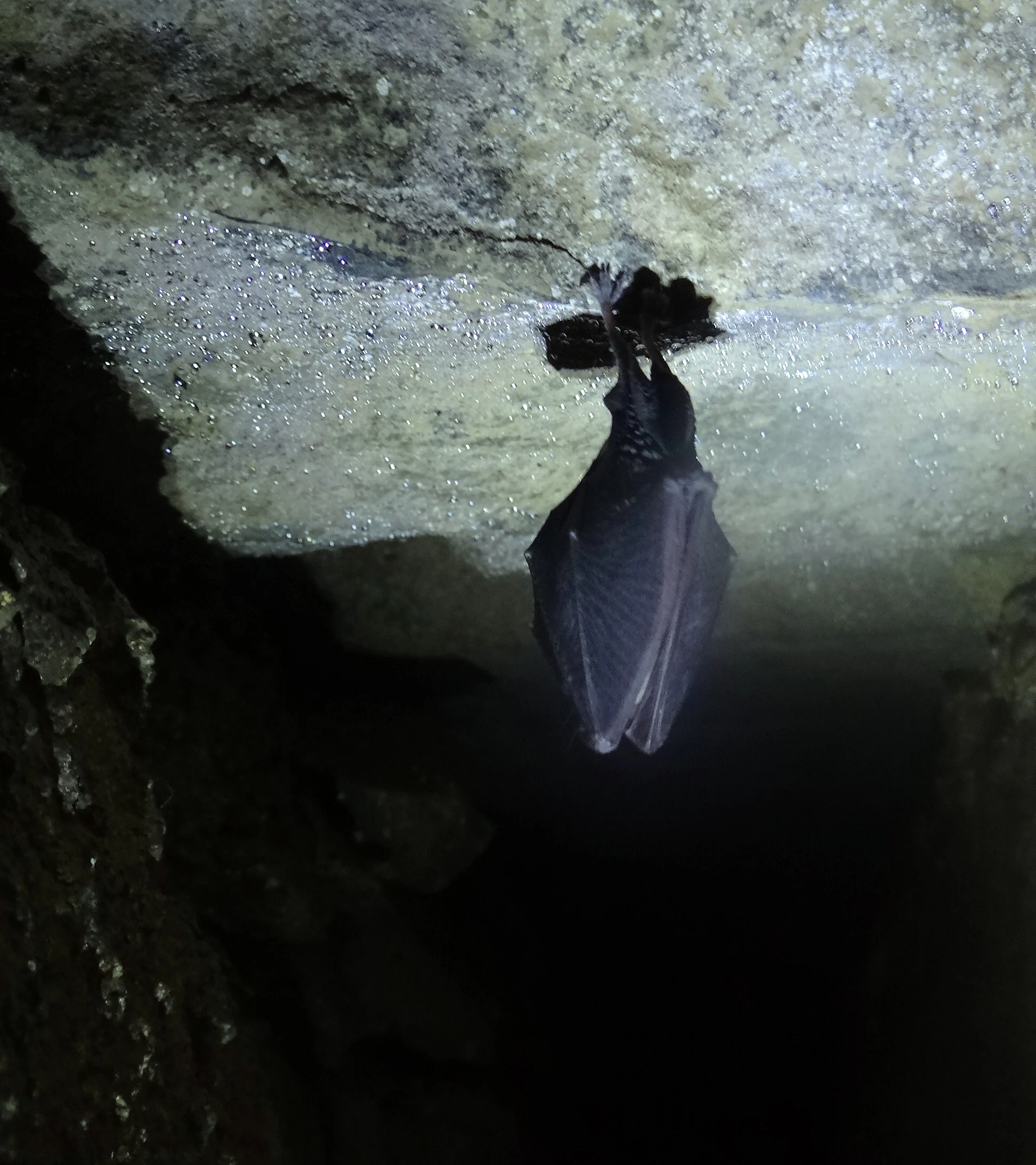
Zlotopienska Dziura cave
A lesser horseshoe bat inside Zlotopienska Dziura cave

Uroczysko Łopień landscape and geographic character

The landscape of Uroczysko Łopień is shaped by the geology of Mount Łopień, one of the typical island-like massifs that give the Beskid Wyspowy range its name. Magura sandstone forms the backbone of the mountain, and its tendency to fracture and slip has produced the Czartorysko landslide, a large slope failure that breaks the otherwise smooth contour of the north-western flank. Here, rocky outcrops, displaced boulders, and a network of small caves have been exposed within an otherwise forested mountainside.

Across the protected area, the terrain shifts between steep slopes, landslide-affected ground, ridges, and gentle upland basins. The second protected parcel around Myconiówka includes open clearings, peat-forming depressions, and surrounding woodland slopes. The combination produces a visibly varied mountain landscape where rocky disturbance zones, forest hollows, and open peatland surfaces meet within a relatively small geographic footprint. Thicknesses of guano deposits reaching roughly ten centimeters in some cave passages reflect the long, undisturbed use of these underground spaces by bat colonies.

Uroczysko Łopień ecosystems, habitats, and plant life

Ecologically, Uroczysko Łopień is defined by the meeting of forest and peatland habitats typical of the western Carpathians. The fertile Carpathian beech forests of the area represent some of the most productive temperate forest stands in the region, layered with characteristic ground vegetation of the Galio odorati-Fagenion type. These broadleaf forests are complemented by distinctly different bog and bog-edge woodland communities, including brzozowo-sosnowe bagienne lasy borealne, Vaccinio uliginosi-Betuletum pubescentis, Vaccinio uliginosi-Pinetum, Pino mugo-Sphagnetum, and Sphagno girgensohnii-Piceetum formations, each representing a specific blend of bog substrate and tree composition.

The high peat bog of Bagna Łopieńskie is one of the defining ecological features of the site, hosting plant species characteristic of nutrient-poor, acidic, waterlogged conditions. The presence of both raised bog vegetation and surrounding Carpathian beech forest within the same protected area creates strong ecological gradients over short distances. Because the site combines so many protected habitat types in such a compact area, it carries significance well beyond its small surface footprint.

Uroczysko Łopień wildlife and species highlights

The wildlife profile of Uroczysko Łopień is dominated by cave-dwelling bats and forest-dependent species that find critical refuge in the protected landscape. Lesser horseshoe bats (Rhinolophus hipposideros) are especially prominent, with roughly five hundred individuals, effectively the entire Beskid Wyspowy population of this species, using caves of the Łopień massif for hibernation. Jaskinia Zbójecka w Łopieniu is one of very few locations in the entire Carpathian range where the fringe-haired bat has been confirmed to hibernate, making the site nationally and regionally important. Bechstein's bat (Myotis bechsteinii) and several additional bat species also use the caves as both summer roosts and winter shelters.

Birdlife of conservation importance in the area includes the black woodpecker and the grey-headed woodpecker, both species associated with mature, semi-natural forest. Among amphibians, the site supports the Carpathian newt and the yellow-bellied toad, two species that depend on clean, undisturbed mountain habitats. The combination of old-growth forests for nesting birds, peat bogs for sensitive amphibians, and stable cave microclimates for year-round bat presence gives the wildlife value of the site unusually broad scope for its size.

Uroczysko Łopień conservation status and protection priorities

Uroczysko Łopień was designated as a Special Area of Conservation under the Natura 2000 framework, with site code PLH120078, in recognition of the high cumulative value of its habitats and species. Several of the bat species present, including the lesser horseshoe bat, Bechstein's bat, the greater mouse-eared bat, and the fringe-haired bat, are classified as priority animal species for conservation in Europe, as are the black woodpecker and the grey-headed woodpecker among birds, and the Carpathian newt and yellow-bellied toad among amphibians.

The Jaskinia Zbójecka w Łopieniu is legally recognized as a natural monument (pomnik przyrody) because of its importance to bats, and as a result the cave itself is closed to public visitation to minimize disturbance during hibernation and summer roosting. The broader conservation logic of the site is that the combination of protected forest types, peatland habitats, and undisturbed caves constitutes an integrated refuge where multiple sensitive species can persist within a single mountain massif.

Top sights and standout views in Uroczysko Łopień

The standout qualities of Uroczysko Łopień lie in its unusual concentration of protected features within a small Carpathian massif. The site brings together a major bat hibernation complex, particularly for the lesser horseshoe bat and the fringe-haired bat, with one of the region’s important raised peat bogs, primeval Carpathian beech forest, and boreal bog woodland types. The closure of Jaskinia Zbójecka to public access also makes the area a notable example of conservation-first cave management in the Polish mountains.

Best time to visit Uroczysko Łopień

The character of Uroczysko Łopień varies meaningfully across the seasons. In winter, the area’s most distinctive ecological feature, bat hibernation in the protected caves, is at its most sensitive, and human access to the caves themselves is legally restricted. Warmer months bring out the broader Carpathian forest and peatland landscapes, with spring and early summer typically the most visually rewarding time for experiencing the beech forest vegetation and peat bog flora, while late summer and early autumn tend to bring drier trails and clearer mountain views across the Beskid Wyspowy. Because the caves are closed to entry year-round for conservation reasons, Uroczysko Łopień is most appropriately experienced as an outdoor mountain landscape rather than a showcave destination.


Monthly climate preview

Measured monthly weather patterns and representative coordinate averages for Lesser Poland Voivodeship

Uroczysko Łopień Climate Normals, Long Term Temperature and Precipitation Rhythm

Uroczysko Łopień exhibits a measured annual temperature range from deep sub-zero winter minimums to warm summer maximums alongside varying daily precipitation rates. Reviewing the complete twelve-month climatology dataset reveals detailed monthly fluctuations across the representative elevation.
Annual mean6 °C
-5 °C17 °C
Jan-5°
Feb-4°
Mar
Apr
May11°
Jun15°
Jul17°
Aug17°
Sep12°
Oct
Nov
Dec-4°
Warmest month
July

16.7 °C

Coolest month
January

-4.9 °C

Wettest month
July

4.4 mm/day

Driest month
December

1.7 mm/day

Park location guide

Geography guide, regional context, and park location map for Uroczysko Łopień

Uroczysko Łopień park geography, regions, and map view in Poland

Understand where Uroczysko Łopień sits in Poland through a broader geographic reading of the surrounding landscape, nearby location context, and its mapped position within the national park landscape.

How Uroczysko Łopień fits into Poland

Poland, officially the Republic of Poland, is a Central European country spanning from the Baltic Sea in the north to the Carpathian Mountains in the south. It borders Germany, Czech Republic, Slovakia, Ukraine, Belarus, Lithuania, and Kaliningrad Oblast. The country has a temperate climate, diverse landscapes, and is known for its rich history, cultural heritage, and strong economic position within the EU.

Wider geography shaping Uroczysko Łopień in Poland

Poland occupies 312,696 km2 in Central Europe, extending from the Baltic Sea coast in the north to the Sudetes and Carpathian Mountains in the south. It borders Germany to the west, Czech Republic and Slovakia to the south, Ukraine and Belarus to the east, and Lithuania and Kaliningrad Oblast to the northeast. The landscape includes lowland plains, uplands, and mountain ranges.

Map view of Uroczysko Łopień

Use this park location map to pinpoint Uroczysko Łopień in Poland, understand its exact geographic position, and read its mapped placement within the surrounding landscape more clearly.

Pigeon | © OpenStreetMap contributors

Location context for Uroczysko Łopień

Lesser Poland Voivodeship
Recorded earthquake history

Examine the Uroczysko Łopień Historical Seismic Activity Catalogue

Browse the documented records of seismic events associated with the Uroczysko Łopień nature reserve. This catalogue from MoriAtlas allows researchers and enthusiasts to trace historical earthquake data, including magnitudes and epicentre distances, for this specific mountain landscape in the Polish Carpathians.

Uroczysko Łopień Earthquake History

Catalogued events

7 events

Strongest magnitude

Magnitude 4.8

Most recent event

Jan 29, 2005

This history includes earthquakes recorded inside the park or within 50 km of its borders

Visual reference for Carpathian beech forests, sandstone caves, and highland peat bogs

Uroczysko Łopień Landscape and Scenery Photography

Examine detailed photographs of Uroczysko Łopień to understand the varied terrain, rocky landslide formations, and forest habitats of Mount Łopień. Visual documentation reveals the distinct protected character of the Beskid Wyspowy mountain environment.

Zlotopienska Dziura cave

Park atlas

Compare nearby mountain reserves and connected forest habitats within the regional landscape

Parks Near Uroczysko Łopień and Protected Areas Across the Surrounding Carpathian Region

Browsing other protected areas near Uroczysko Łopień reveals shared geological formations and mountain forest ecosystems across the southern Polish uplands. Extending the geographic comparison helps trace regional conservation networks and connected wildlife habitats within the wider mountain terrain.
Nature reserveWojewództwo małopolskie
About 3.9 km away#1 closest

South

Rezerwat przyrody Mogielica: Mapping Protected Forests and Summit Terrain in the Beskid Wyspowy

A vital Carpathian nature reserve and bird sanctuary

Located at the highest point of the Beskid Wyspowy, Rezerwat przyrody Mogielica is a significant protected area dedicated to forest conservation and the preservation of rare wildlife, including the capercaillie. This site showcases unique geological features around its rocky summit and preserves intact montane forest gradients that characterize the natural heritage of the Polish Carpathians.

Area
0.504 km²
Established
2011
Relief
Mountain
Climate
Temperate
Nature reserveLesser Poland Voivodeship
4.5 km away#2 closest

Southwest

Ostoja Gorczańska: Protected Area Mapping and Carpathian Mountain Geography in Lesser Poland

Ecological corridors across the Gorce and Beskid Wyspowy ranges

Covering nearly 18,000 hectares, Ostoja Gorczańska represents a significant biodiversity reservoir in the Polish Carpathians. The site integrates multiple protection frameworks, safeguarding varied habitats from subalpine grasslands to dense montane forests and peatland depressions. Use this resource to examine the structural connectivity of these mountain units and the expansive wilderness corridors found within the Lesser Poland Voivodeship.

Area
179.979 km²
Established
2008
Relief
Mountain
Climate
Temperate
Nature reserveLesser Poland Voivodeship
8.3 km away#3 closest

West

Łąki koło Kasiny Wielkiej: Protected Meadow Habitats in Lesser Poland Voivodeship

Ecological mapping of traditional Carpathian grassland ecosystems.

Łąki koło Kasiny Wielkiej is a specialized nature reserve in the Beskid Wyspowy range, protecting fragmented semi-natural meadows that represent essential habitat types within the European Natura 2000 network. By analyzing the site boundaries and regional landscape context within Lesser Poland Voivodeship, this entry provides insight into how low-intensity farming preserves distinctive grassland flora and terrain structure in the Carpathian foothills.

Area
0.244 km²
Established
2011
Relief
Mountain
Climate
Temperate
Protected areaLesser Poland Voivodeship
9.7 km away#4 closest

Southeast

Środkowy Dunajec z dopływami: Protected River Habitats and Carpathian Foothills Geography

Exploring the river corridor and riparian ecosystems of southern Poland

Spanning 755 hectares across four connected enclaves, Środkowy Dunajec z dopływami protects the vital riverine systems of the middle Dunajec and its tributaries. This site offers a unique look at the fluvial processes and biodiversity of Carpathian mountain streams, showcasing diverse habitat structures from pioneer gravel banks to mature riparian forests.

Area
7.56 km²
Relief
Upland
Scope
Terrestrial
Water
Major water bodies
Watercolor painting showing rolling green hills, forests, and distant mountains under a pale sky
National parkLesser Poland Voivodeship
11 km away#5 closest

Southwest

Gorce National Park: A Comprehensive Geographic Profile and Protected Area Analysis

Mountain meadows and Carpathian forest landscapes in southern Poland

Gorce National Park preserves an essential segment of the Western Beskids, offering a look into the region's arched ridges and forested terrain. The area serves as a critical protected landscape featuring significant biodiversity, ancient woodland, and open mountain meadows that distinguish the local geography of the Lesser Poland Voivodeship.

Area
70.3 km²
Established
1981
IUCN
II
Visitors
80K annual
National parkLesser Poland Voivodeship
11 km away#6 closest

Southwest

Gorczański Park Narodowy: Protected Mountain Geography in Lesser Poland Voivodeship

Carpathian forest and mountain clearing atlas

Gorczański Park Narodowy serves as a critical protected landscape in the Polish Carpathians. This atlas entry details the park's topography, including the dominant Turbacz massif, extensive forest corridors, and the ecological significance of its seepage meadows and high-altitude grasslands.

Area
70.3 km²
Established
1981
Visitors
92K annual
Relief
Mountain
Protected areaLesser Poland Voivodeship
16 km away#7 closest

West

Raba z Mszanką Protected Area: Atlas of Carpathian Riverine and Riparian Landscapes

Geographic map and habitat overview for southern Poland.

Raba z Mszanką serves as a significant protected corridor within the Lesser Poland Voivodeship. The site illustrates the ecological gradient of mountain stream environments, featuring shifting gravel bars, willow shrublands, and floodplain forests. This entry provides context on the riverine geography, including its role in sustaining populations of the Mediterranean barbel within the Carpathian foothills.

Area
2.493 km²
Scope
Terrestrial
Water
Major water bodies
Protected areaLesser Poland Voivodeship
22 km away#8 closest

Southeast

Ostoja Popradzka: Mapped Protected Landscapes and Geographic Context in Southern Poland

A core conservation site within the Beskid Sadecki mountain range

Spanning extensive river valleys and alpine meadows, Ostoja Popradzka serves as a primary habitat network in the Polish Carpathians. This entry details its layered geography, including protected forest reserves, karst cave systems, and essential corridors for large carnivores, framed within the administrative boundaries of the Lesser Poland Voivodeship.

Area
579.31 km²
Established
2008
Relief
Mountain
Scope
Terrestrial

Common questions about visiting, size, designation, and location context for Uroczysko Łopień

Uroczysko Łopień FAQs for park facts, access, geography, and protected area context

Find quick answers about Uroczysko Łopień, including protected-area facts, park geography, trail and visitor context, and how the park fits into its surrounding country and regional landscape.
MoriAtlas Explorer

Continue Your Protected Areas Search Across the Global Atlas

Deepen your exploration by continuing the structured search for national parks and protected areas worldwide. Utilize the comprehensive filtering capabilities to compare different conservation landscapes and refine your understanding of global park geography. Discover more about the distribution and characteristics of protected natural areas.

Global natural geography