
Mori Atlas logo
Nature reserveVallée du Soussouéou

A remote, roadless mountain refuge defined by glacial geography and protected peatland ecosystems

Vallée du Soussouéou Nature Reserve: Protected Glacial Landscapes in the Western Pyrenees

(Vallée glaciaire du Soussouéou)

The Vallée du Soussouéou represents a significant protected area within the Pyrénées-Atlantiques department of France. Carved by historical glacial action, this valley forms a broad U-shaped corridor that remains free of vehicular roads, providing a rare stretch of continuous high-mountain habitat. The area is home to the tourbière de Soussouéou, a peatland of national ecological importance, and serves as an essential wildlife refuge adjacent to the Parc national des Pyrénées.

glacial valleyPyreneeswestern Pyreneesmountain valleypeatlandZNIEFF
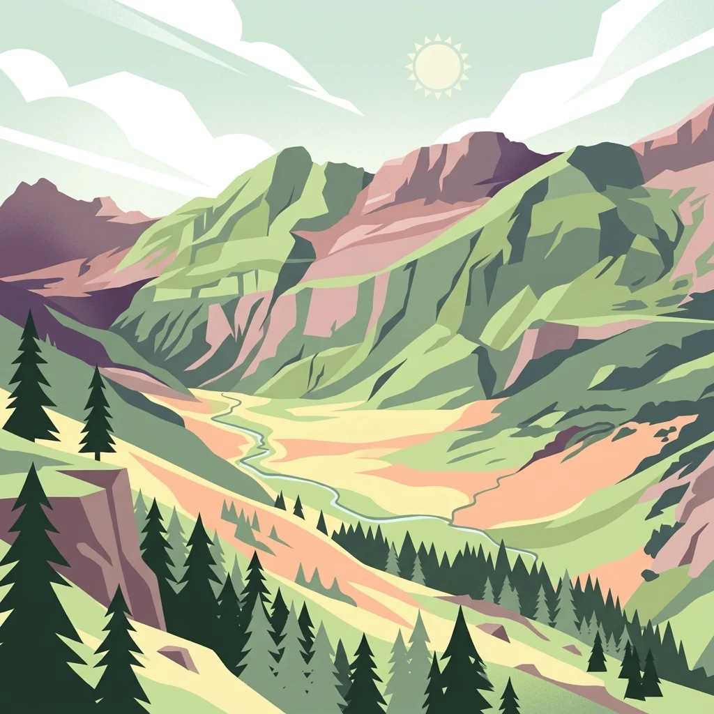
A stylized digital illustration of a mountain valley in the Pyrenees featuring pine trees, rocky ridges, and a small stream under a sunny sky.

Vallée du Soussouéou

Nature reserve

Park overview

Structured park overview, official facts, and landscape profile for Vallée du Soussouéou

Vallée du Soussouéou park facts, protected area profile, and essential visitor context

Review the core facts for Vallée du Soussouéou, including designation, size, terrain, visitor scale, habitats, and operating context in one park-focused overview.

About Vallée du Soussouéou

The Vallée du Soussouéou occupies a distinctive niche within the protected natural heritage of the Pyrenees. Situated in the commune of Laruns, in the arrondissement of Oloron-Sainte-Marie and the Pyrénées-Atlantiques department, the valley lies within the broader Ossau valley system of the western Pyrenees. Its position downstream of Lac d'Artouste places it at a transitional elevation where glacial landforms, alpine meadows, and forested slopes converge, creating a layered mosaic of Pyrenean landscapes.

The valley is fundamentally defined by its glacial origin. Past ice flows shaped its broad profile and gentle gradient, while the Gave de Soussouéou continues to carve its bed through the inherited valley floor. This combination of geological inheritance and ongoing fluvial activity produces the alternating rocky channels, alluvial flats, and damp hollows where peat can accumulate. The tourbière de Soussouéou, classified at the national level, sits within this setting and represents one of the valley's most ecologically sensitive features.

Beyond its physical character, the Soussouéou stands out for the legal and administrative protection it has received. Designated in 1995 as a ZNIEFF (Zone Naturelle d'Intérêt Écologique, Faunistique et Floristique) of type I, the area covers about 4,539 hectares and functions as a buffer and ecological extension of the nearby Parc national des Pyrénées, even though it does not officially belong to the national park itself. This intermediate status makes the valley an interesting case study in the layered approach to nature conservation in France, where national parks, regional natural areas, and peatland protections overlap in a single landscape.

The absence of any vehicular road through the valley reinforces its protected character. Hikers reach the area chiefly via the GR 10 long-distance trail, one of the most important footpaths across the Pyrenees, while pastoralists continue traditional seasonal practices that connect the valley to long-standing transhumance culture in the Béarn region. The combination of official protection, ecological richness, and limited modern infrastructure gives the Vallée du Soussouéou a strong identity as a quiet, high-value Pyrenean natural area.

Quick facts and research context for Vallée du Soussouéou

The Vallée du Soussouéou is a glacial valley situated on the commune of Laruns in the Pyrénées-Atlantiques department, within the Nouvelle-Aquitaine region of France. It lies in the western Pyrenees, downstream of Lac d'Artouste, and is oriented northwest then west along the course of the Gave de Soussouéou.

The area was officially designated as a ZNIEFF of type I in 1995, under regional reference number 66040003, covering approximately 4,539 hectares. It functions as a natural extension of the Parc national des Pyrénées without being part of it, and contains a peatland classified as being of national importance.

Protection and recognition

Review documented terrestrial protection scope and conservation management records.

Vallée du Soussouéou Protection Status and Formal Designation History

Terrestrial protection status for Vallée du Soussouéou encompasses documented management scope and official administrative records. Verified conservation metrics provide transparent access to international designation data and baseline status facts.

Protection details

Protection scope
Terrestrial
Park context

Deeper park guide and search-rich context for Vallée du Soussouéou

Vallée du Soussouéou history, landscape, wildlife, and travel context

Explore Vallée du Soussouéou through its history, landscape character, ecosystems, wildlife, conservation priorities, cultural context, and seasonal travel timing in a structured park guide built for atlas discovery and search intent.

Why Vallée du Soussouéou stands out

The Vallée du Soussouéou is best known for being one of the rare roadless glacial valleys remaining in the French Pyrenees. Its long U-shaped profile, shaped by past glaciation, and the absence of any vehicular through-route preserve a continuous stretch of high-mountain habitat in an otherwise heavily developed mountain range. The valley is also recognized for the ecological value of its peatland, the tourbière de Soussouéou, which holds national-level significance. Its protected status as a ZNIEFF of type I and its role in extending the ecological reach of the surrounding Pyrenean national park contribute to its reputation as a quiet but important refuge for Pyrenean wildlife.
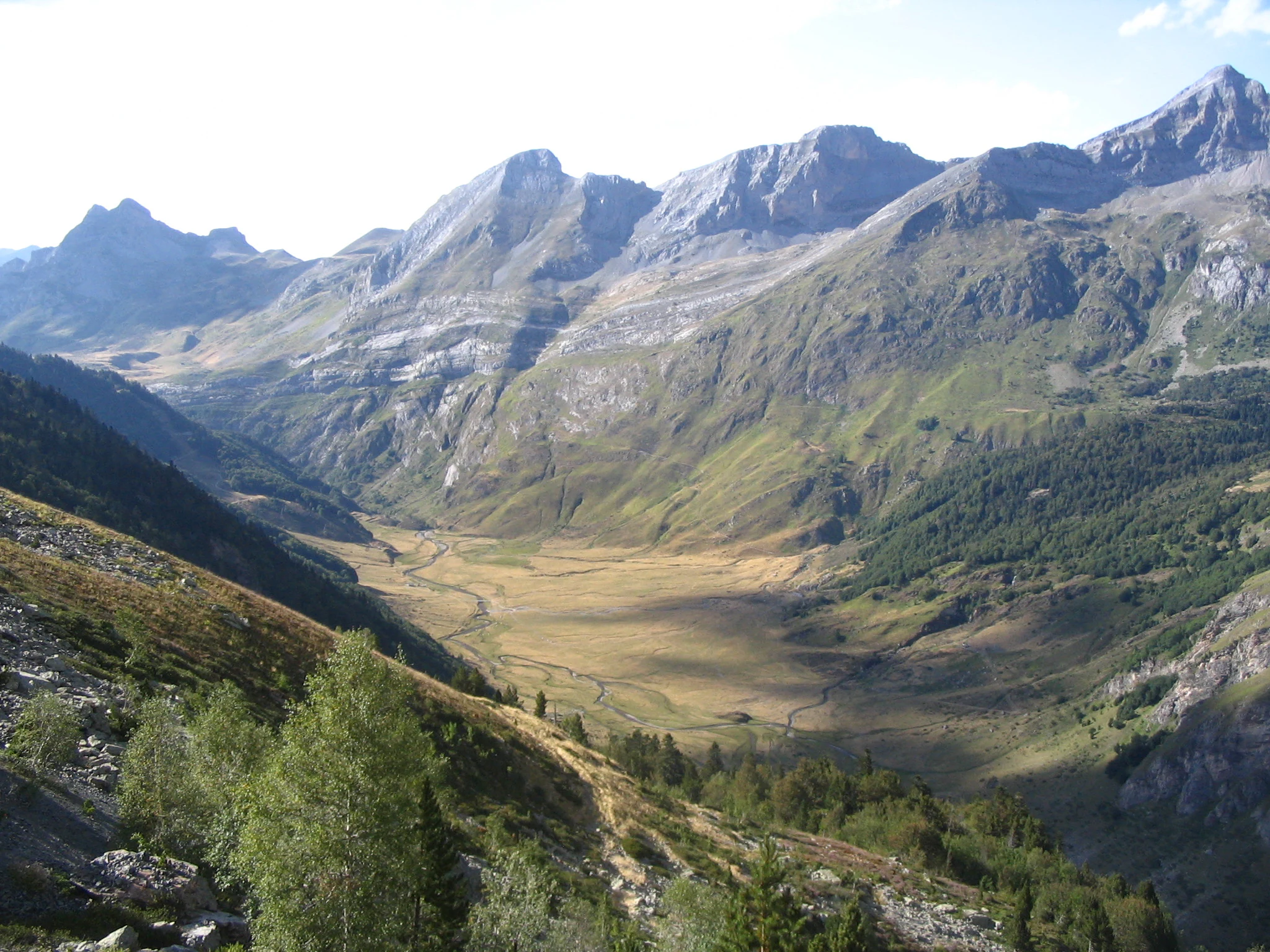
A high-angle, wide shot of a broad mountain valley in the Pyrenees featuring a winding stream through a grassy basin, surrounded by steep, rocky slopes and alpine ridges.
A wide view of the glacial valley of the Gave de Soussouéou in the French Pyrenees.

Vallée du Soussouéou history and protected-area timeline

The documented history of the Vallée du Soussouéou is largely a history of protection rather than settlement. The valley has long been part of the broader Ossau valley system of the Béarn province, where pastoral activities, including seasonal grazing in mountain pastures, have shaped land use for centuries. Detailed written history of the valley itself is sparse, in line with the limited human footprint the area has historically carried.

In the 1970s, the valley became the focus of a major development proposal. A project was planned to build a high-altitude resort village of approximately 2,000 beds in the Soussouéou area, reflecting the era's enthusiasm for large-scale mountain tourism in the Pyrenees. The project was eventually abandoned, leaving the valley free of the road infrastructure and built environment that similar schemes introduced elsewhere in the range.

The defining administrative moment in the valley's modern history came in 1995, when it was designated as a ZNIEFF of type I under regional reference number 66040003. This designation formalized recognition of its ecological importance and tied it into the wider French inventory of natural heritage. Separately, the peatland within the valley, the tourbière de Soussouéou, was classified as being of national importance, adding another layer of protection to a sensitive part of the landscape.

Vallée du Soussouéou landscape and geographic character

The Vallée du Soussouéou presents a classic Pyrenean glacial profile. The valley is broad and U-shaped, shaped by ice that once flowed down from the higher massifs above Lac d'Artouste. The downstream orientation is northwest then west, giving the valley a sweeping curve that opens gradually toward the lower Ossau basin.

The floor of the valley follows the Gave de Soussouéou, a mountain torrent whose ongoing work has left a mixture of rocky beds, gravel bars, and softer alluvial flats. These flat areas, combined with damp hollows and side depressions, create conditions that support peat formation, which is why the tourbière de Soussouéou has developed here and been recognized for its national-level importance.

Above the valley floor, the slopes rise into typical Pyrenean terrain, with a mix of alpine meadows, rocky outcrops, and forested transitions. The combination of open glacial valley, active watercourse, peatland, and steep surrounding slopes gives the Soussouéou a layered and visually varied landscape, characteristic of high glacial valleys in the western Pyrenees.

Vallée du Soussouéou ecosystems, habitats, and plant life

Ecologically, the Vallée du Soussouéou functions as a transitional zone between the subalpine and alpine levels of the western Pyrenees. Its glacial valley floor, peatland, meadows, and forested edges support a wide range of habitats within a relatively compact area. This habitat diversity is one of the main reasons the valley warranted its 1995 designation as a ZNIEFF of type I.

The peatland, or tourbière, is one of the most ecologically distinctive elements. Peatland ecosystems in the Pyrenees are limited and locally significant, and the national-level classification of the tourbière de Soussouéou reflects both its rarity and its biological value. Such environments support moisture-loving plant communities and serve as reservoirs within the broader mountain hydrological cycle.

More broadly, the valley's vegetation transitions include subalpine grasses and herbs, with species such as Androsace cylindrica, Alpine armeria, and purple sandwort noted on rocky or open ground. Bog-loving plants like round-leaved sundew also appear in damp habitats. The combination of peatland vegetation, alpine meadows, and rocky slopes contributes to a botanical profile that is varied and meaningful for the region.

Vallée du Soussouéou wildlife and species highlights

The Vallée du Soussouéou supports a typical range of Pyrenean mountain fauna, with species adapted to both forested slopes and open alpine terrain.

Among amphibians, the Pyrenean brook salamander is recorded in the valley, a species strongly associated with clean, cool mountain streams and a useful indicator of habitat quality.

Mammal life includes species spread across different Pyrenean elevations. The snow vole, the Pyrenean chamois (isard), the Pyrenean desman, the stoat (ermine), the marmot, and the Pyrenean brown bear are all noted as part of the valley's mammalian fauna. The presence of the brown bear gives the area particular conservation significance, as the Pyrenean bear population remains one of the most threatened in Europe.

Birdlife is diverse and includes both resident mountain species and birds of prey. Recorded species include the alpine accentor, dunnock, golden eagle, northern goshawk, red crossbill, white-throated dipper, common cuckoo, Eurasian sparrowhawk, mistle thrush, rock ptarmigan, ring ouzel, long-tailed tit, marsh tit, common rock thrush, snow finch, tree pipit, white-backed woodpecker, great spotted woodpecker, lesser spotted woodpecker, black woodpecker, water pipit, common chiffchaff, Eurasian nuthatch, northern wheatear, western capercaillie, wallcreeper, and citril finch. The presence of the capercaillie, the wallcreeper, and the golden eagle underlines the valley's value for high-mountain and cliff-nesting birdlife.

Vallée du Soussouéou conservation status and protection priorities

The Vallée du Soussouéou holds a recognized but somewhat singular position within the French conservation framework. It was designated in 1995 as a ZNIEFF of type I under regional reference number 66040003, placing it in the national inventory of natural areas of ecological, faunistic, and floristic interest. This designation does not confer the same legal protections as a national park or nature reserve, but it does formally acknowledge the area's ecological importance and guides planning and management decisions.

Although the valley lies adjacent to the Parc national des Pyrénées and effectively extends its ecological continuity into the Ossau system, it does not formally belong to the national park itself. This makes it an important complementary area, contributing to landscape-level connectivity and helping to buffer core park habitats. The tourbière de Soussouéou, classified at the national level, adds a specific layer of protection to the valley's most sensitive habitat.

From a conservation perspective, the valley's roadless character is itself a major asset. The absence of vehicular infrastructure reduces habitat fragmentation, limits disturbance to large mammal species such as the Pyrenean brown bear, and preserves large continuous tracts of habitat. Combined with its inclusion in pastoral activities rather than intensive development, the Soussouéou remains a relatively intact example of the Pyrenean glacial-valley ecosystem.

Vallée du Soussouéou cultural meaning and human context

The Vallée du Soussouéou sits within the Béarn region, a part of the western Pyrenees with a deeply rooted mountain pastoral culture. Seasonal movement of livestock between lowland farms and high summer pastures, known as transhumance, has long shaped land use across the Ossau valley system, and pastoralism remains an active part of life in the commune of Laruns and its surroundings. Pastoralism continues in the area today, and introductory courses in pastoral practices are organized locally, linking the valley's natural and cultural heritage.

The valley is also defined by what did not happen. In the 1970s, a project for a 2,000-bed high-altitude resort village was seriously considered for the area, echoing similar developments elsewhere in the Pyrenees and the Alps. Its abandonment left the Soussouéou as one of the valleys that preserved its traditional Pyrenean mountain character rather than being transformed into a large-scale tourism center.

Top sights and standout views in Vallée du Soussouéou

The Vallée du Soussouéou offers a rare combination of glacially sculpted scenery, ecological richness, and human quietness. Its roadless character, set between Lac d'Artouste upstream and the broader Ossau valley downstream, makes it one of the most uninterrupted glacial valleys in the western Pyrenees.

Ecologically, the valley stands out for the national-level recognition of its peatland, the diversity of its Pyrenean mammal fauna, and its role as a non-park extension of the Parc national des Pyrénées. Hikers, naturalists, and those interested in traditional mountain land use find here an example of a Pyrenean landscape where protection, pastoral activity, and wilderness coexist.

Best time to visit Vallée du Soussouéou

The Vallée du Soussouéou is most naturally experienced during the Pyrenean summer and early autumn months, when high-altitude snow has melted from the valley floor and the GR 10 trail is fully accessible on foot. In this season, alpine meadows are at their most visible, peatlands are active, and the variety of birdlife and mammal activity is at its peak. Snow and winter conditions can make the valley floor difficult to access safely on foot, which is consistent with its general character as a quiet, lightly visited area. Visitors interested in pastoral culture will likely find that summer is also the period when traditional transhumance and pastoralist activity are most visible in the surrounding Laruns area.
Monthly climate preview

Long-term representative monthly temperature and precipitation patterns

Vallée du Soussouéou Climate Normals and Annual Temperature Rhythm

Representative coordinates record measured multi-year temperature variations alongside steady monthly precipitation levels across the terrain. Reviewing the complete twelve-month climatology profile reveals deeper numerical context for annual meteorological rhythms.
Annual mean10 °C
3 °C19 °C
Jan
Feb
Mar
Apr
May12°
Jun16°
Jul18°
Aug19°
Sep15°
Oct11°
Nov
Dec
Warmest month
August

18.9 °C

Coolest month
January

2.8 °C

Wettest month
November

3.5 mm/day

Driest month
August

1.6 mm/day

Park location guide

Geography guide, regional context, and park location map for Vallée du Soussouéou

Vallée du Soussouéou park geography, regions, and map view in France

Understand where Vallée du Soussouéou sits in France through a broader geographic reading of the surrounding landscape, nearby location context, and its mapped position within the national park landscape.

How Vallée du Soussouéou fits into France

France is a unitary semi-presidential republic and one of the world's largest economies. It borders Belgium, Luxembourg, Germany, Switzerland, Italy, Monaco, Andorra, and Spain, with a maritime border to the United Kingdom. The country is known for its cultural influence, art, cuisine, and political history spanning centuries.

Wider geography shaping Vallée du Soussouéou in France

France is located in Western Europe. Metropolitan France extends from the Rhine to the Atlantic Ocean and from the Mediterranean Sea to the English Channel and North Sea. The country borders Belgium, Luxembourg, Germany, Switzerland, Italy, Monaco, Andorra, Spain, and has a maritime border with the United Kingdom.

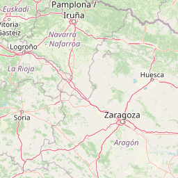
Map view of Vallée du Soussouéou

Use this park location map to pinpoint Vallée du Soussouéou in France, understand its exact geographic position, and read its mapped placement within the surrounding landscape more clearly.

Pigeon | © OpenStreetMap contributors

Location context for Vallée du Soussouéou

Nouvelle-AquitainePyrénées-Atlantiques

Visual reference collection showcasing mountain terrain, protected habitats, and remote valley character

Vallée du Soussouéou Photos, Scenery, and Glacial Landscapes

Visual documentation captures the rugged terrain, glacial valleys, and protected habitats characteristic of the high Pyrenees. Examining these landscape views reveals the unique environmental profile and undisturbed character of the protected area.

A high-angle, wide shot of a broad mountain valley in the Pyrenees featuring a winding stream through a grassy basin, surrounded by steep, rocky slopes and alpine ridges.

A wide view of a deep, rocky glacial valley in the French Pyrenees with forested slopes and mountain ridgelines.

Park atlas

Compare surrounding mountain valleys and connected regional conservation landscapes

Parks Near Vallée du Soussouéou and Related Pyrenean Protected Areas

Browsing other protected areas near Vallée du Soussouéou reveals broader ecological patterns across the western Pyrenees mountain range. Comparing nearby glacial terrain and high altitude habitats provides deeper context for regional mountain conservation.
National parkHautes-Pyrénées
About 3.5 km away#1 closest

Southeast

Pyrénées National Park: Protected Landscape & Transboundary Protected Area Atlas

Discover Hautes-Pyrénées' dramatic glacial terrain and alpine environments.

Pyrénées National Park is a significant protected area in France's Hautes-Pyrénées department, renowned for its dramatic glacial cirques, high-altitude lakes, and extensive mountain landscapes. Established as a national park, it offers rich geographic context for atlas exploration, showcasing millions of years of geological formation shaped by tectonic uplift and glacial carving. This park is also notable for its transboundary conservation efforts with Spain, contributing to a broader protected region. Explore its unique terrain, from towering limestone formations to alpine meadows, and understand its place within the Pyrenean mountain range.

Area
458 km²
Established
1967
IUCN
II
Relief
Mountain
A watercolor illustration of rolling mountain ranges and stylized forest patches in soft green and earth tones against a pale background.
Nature reserveOccitanie
About 25 km away#2 closest

Northeast

Réserve naturelle régionale du massif du Pibeste-Aoulhet: Mountain Reserve Atlas

Regional protected landscape mapping in the French Pyrenees

Spanning over 5,000 hectares in the Occitanie region, the Réserve naturelle régionale du massif du Pibeste-Aoulhet serves as a critical biological corridor. This detailed record examines the massif's varied elevations, from lower broadleaf forests to high-altitude rocky cliffs, highlighting its status as one of the largest regional nature reserves in France.

Area
51.103 km²
Established
2012
IUCN
IV
Relief
Mountain
Watercolor painting showing a mountain range with a winding river through a valley
National parkSpain
About 33 km away#3 closest

Southeast

Ordesa y Monte Perdido National Park: Glacial Terrain and Pyrenean Protected Landscape

Explore its dramatic valleys, cliffs, and alpine geography.

Ordesa y Monte Perdido National Park is a critical protected area within the Pyrenean geography, defined by its spectacular glacial valleys, towering limestone massifs, and unique karst formations. As a National Park and UNESCO World Heritage Site, it offers a rich environment for exploring mapped terrain and understanding the interplay of geology and high-alpine ecosystems. Delve into the mapped boundaries and distinct landscape features that characterize this significant protected landscape.

Area
156.08 km²
Established
1918
IUCN
II
Relief
Mountain
A soft watercolor painting of rolling green hills, distant mountain peaks, and a calm water body against a white background.
National parkOccitanie
About 41 km away#4 closest

Southeast

Pyrénées-Mont Perdu National Park: Alpine Geography and Transboundary Protected Landscapes

Glacial cirques, limestone canyons, and alpine pastoral heritage.

Spanning the high Pyrenees, Pyrénées-Mont Perdu represents a rare union of dramatic geological formations and human cultural heritage. The terrain features vertical limestone walls, deep carved canyons, and expansive cirques that host both diverse alpine ecosystems and active seasonal migration routes. This protected area remains a benchmark for studying the interplay between powerful glacial geography and historic mountain pastoralism in Europe.

Area
306.39 km²
Established
1997
Relief
Mountain
Climate
Alpine
A soft, watercolor painting depicting distant purple-hued mountain ranges fading into a pale, warm-toned sky, with light green hills and hints of pine forests in the foreground.
Nature reserveOccitanie
About 54 km away#5 closest

East

Réserve naturelle régionale d'Aulon: Mountain Geography and Protected Area Mapping

A diverse protected landscape spanning the central Pyrenees of Occitanie.

This regional nature reserve provides a focused look at central Pyrenean mountain environments. Covering over 1,200 hectares, the area features a steep altitudinal gradient, blending working pastoral meadows with critical habitats such as rocky slopes, conifer forests, and glacial landforms. The site serves as a vital anchor within the broader network of protected mountain terrain found throughout the Occitanie region.

Area
12.37 km²
Established
2001
IUCN
IV
Relief
Mountain
A watercolor painting of a serene mountain landscape featuring gentle rolling hills, small clusters of trees, and soft, muted tones of green, pink, and purple, set against a light background.
Nature reserveOccitanie
About 66 km away#6 closest

East

Réserve naturelle régionale du Massif du Montious: Regional Nature Reserve in Occitanie

Granitic massif geography and Pyrenean protected landscapes

Located in the heart of the Hautes-Pyrénées, this reserve captures the geological and biological essence of the Central Pyrenees. From the summit grasslands at 2,171 metres to the sheltered glacial basins, the terrain provides a comprehensive look at regional mountain ecosystems and Hercynian geological heritage.

Area
7.38 km²
Established
2020
IUCN
IV
Watercolor illustration of a mountainous landscape with a river, green vegetation, and distant peaks under a light sky
National parkProvince of Lleida
About 102 km away#7 closest

East

Aigüestortes i Estany de Sant Maurici National Park: Pyrenean High Mountain National Park Landscape

Explore glacial lakes and winding waterways in Catalonia.

Aigüestortes i Estany de Sant Maurici National Park is a premier national park in the Pyrenees, celebrated for its extensive network of almost 200 glacial lakes and the dramatic natural beauty of the Sant Maurici lake. Its landscape is defined by high mountain terrain, characterized by U-shaped valleys, sharp ridges, and unique hydrological features like the Aigüestortes plain's meandering streams. This protected area in the Province of Lleida offers a rich setting for understanding alpine environments and Pyrenean geography through detailed mapping and atlas exploration.

Area
141 km²
Established
1955
IUCN
II
Visitors
525K annual
A soft watercolor illustration showing rolling green hills, patches of trees, and a distant horizon in shades of light green and pale yellow.
Nature reserveNouvelle-Aquitaine
About 106 km away#8 closest

Northwest

Réserve naturelle régionale du site des carrières de Tercis-les-Bains Protected Landscape

Geological stratotype and Cretaceous fossil reference site in Nouvelle-Aquitaine

This unique nature reserve in southwestern France protects a globally significant Cretaceous geological sequence within former limestone quarries. It serves as a vital scientific landmark for stratigraphy, housing extensive fossil records and structural evidence of salt-driven geology, all set within the scenic terrain of the Adour river basin.

Area
0.448 km²
Established
2015
IUCN
IV
Relief
Lowland

Common questions about visiting, size, designation, and location context for Vallée du Soussouéou

Vallée du Soussouéou FAQs for park facts, access, geography, and protected area context

Find quick answers about Vallée du Soussouéou, including protected-area facts, park geography, trail and visitor context, and how the park fits into its surrounding country and regional landscape.
MoriAtlas Explorer

Continue Your Protected Areas Search Across the Global Atlas

Deepen your exploration by continuing the structured search for national parks and protected areas worldwide. Utilize the comprehensive filtering capabilities to compare different conservation landscapes and refine your understanding of global park geography. Discover more about the distribution and characteristics of protected natural areas.

Global natural geography