Mori Atlas logo
Natural monumentVelký Karasín

A vital eutrophic pond ecosystem featuring reed beds and sedge meadows within the České Budějovice District landscape.

Velký Karasín Natural Monument: Mapped Protected Landscapes and Wetland Geography in South Bohemia

Velký Karasín stands as a precisely defined natural monument in the South Bohemian Region, preserving a critical wetland mosaic along the Bezdrevský stream tributary. This protected area encompasses an eutrophic pond surrounded by dense reed stands and wet sedge meadows, creating a high-density habitat for migratory birds and rare dragonfly species. The geography of the site offers a window into the delicate transition between open water and damp grassland, representing a key component of the protected land network within the Czech Republic.

wetlandfishpondreed bedssedge meadowsbirdwatchingmigratory birds

Velký Karasín

Natural monument

Park overview

Structured park overview, official facts, and landscape profile for Velký Karasín

Velký Karasín park facts, protected area profile, and essential visitor context

Review the core facts for Velký Karasín, including designation, size, terrain, visitor scale, habitats, and operating context in one park-focused overview.

About Velký Karasín

Velký Karasín sits in a quiet corner of the South Bohemian countryside, in a region traditionally shaped by a network of artificial fishponds and agricultural land. Despite its modest size, the site captures a characteristic fragment of the lowland wetland landscape that has historically defined much of southern Bohemia.

The core of the protected area is an approximately eight-hectare eutrophic pond, which receives nutrient-rich water from a small right-bank tributary of the Bezdrevský stream. Such ponds are typical of the Czech pond systems, where centuries of fish cultivation and water management have created a distinctive mosaic of open water, fringing vegetation, and damp meadows. In Velký Karasín, the western portion of the pond has retained particularly well-developed littoral plant communities, including extensive reed beds that fringe the shoreline. Beyond the water's edge, wet sedge meadows continue the wetland gradient, providing habitat for moisture-dependent plants and invertebrates.

The protection of the site is specifically directed at this western part of the pond and its immediate surroundings, where the combination of open water, reeds, and meadows supports a concentration of biodiversity that would not otherwise be guaranteed in the intensively managed agricultural matrix of the district. The ecological interest of Velký Karasín extends beyond birds and plants: 20 species of dragonflies have been recorded here, an indication of healthy aquatic invertebrate communities in shallow, vegetated water.

By safeguarding such a compact wetland complex, Velký Karasín contributes to the wider network of small protected sites that collectively preserve the natural heritage of the South Bohemian Region, even where larger national parks or landscape protected areas are absent.

Quick facts and research context for Velký Karasín

Velký Karasín is classified as a přírodní památka (natural monument) under Czech nature protection law and falls within IUCN Category IV (habitat/species management area). It lies in the Jihočeský kraj, in the okres České Budějovice, near the village of Vlhlavy at roughly 405 to 407 meters above sea level. The protected area covers about 10.78 hectares and was designated on 30 December 1991 by the former Okresní úřad České Budějovice. The site is documented in the national nature conservation register under code 1401.

Protection and recognition

Documented establishment records, terrestrial scope, and recognition history for Velký Karasín

Velký Karasín Protection Status and Designated Terrestrial Conservation History

Established in 1991 with a terrestrial protection scope, Velký Karasín maintains documented conservation records and historical designation data. Official administrative facts outline the foundational status of the protected landscape without external recognition sources.

Protection details

Protection scope
Terrestrial
Designated year
1991
Transboundary protection
No
Park context

Deeper park guide and search-rich context for Velký Karasín

Velký Karasín history, landscape, wildlife, and travel context

Explore Velký Karasín through its history, landscape character, ecosystems, wildlife, conservation priorities, cultural context, and seasonal travel timing in a structured park guide built for atlas discovery and search intent.

Why Velký Karasín stands out

Velký Karasín is best known as a small but ecologically valuable eutrophic pond with intact littoral reed stands and adjacent wet sedge meadows. It is particularly recognized for its importance to waterbirds and wetland birds, both as nesting habitat and as a stopover during migration, as well as for its rich dragonfly fauna, which includes the Europe-wide endangered Sympecma fusca.
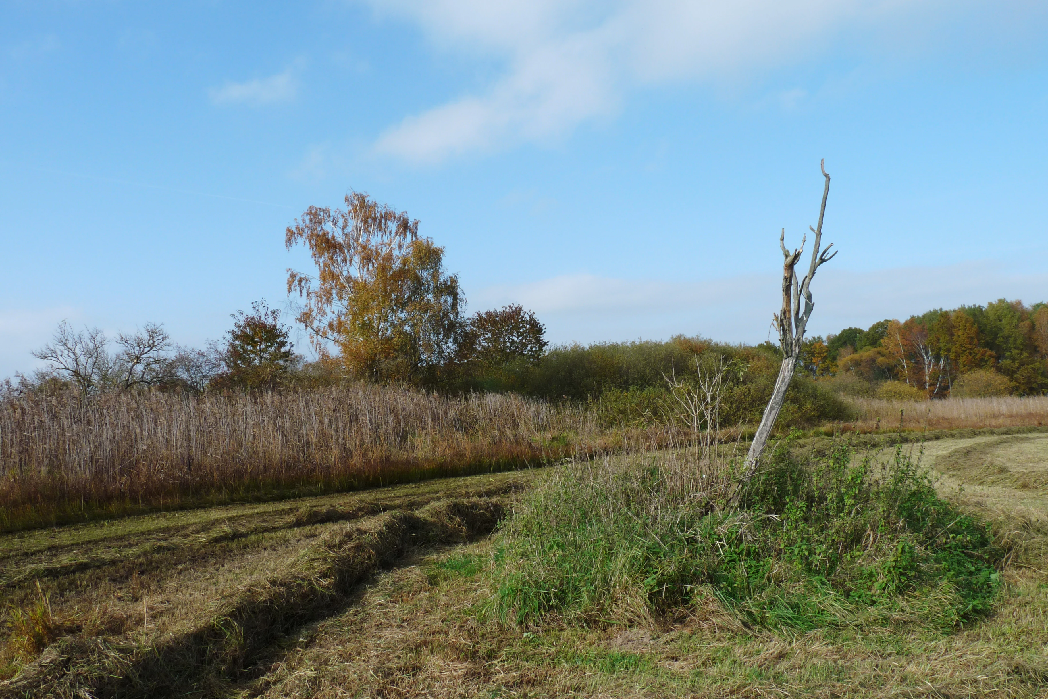
A wetland landscape with tall brown reed beds along a grassy bank, a dead tree trunk leaning to the right, green and brown vegetation, and trees with autumn foliage in the background under a blue sky with light clouds.
Wetland landscape at Velký Karasín Nature Monument showing reed beds, grassy margins, and autumn trees under a blue sky.

Velký Karasín history and protected-area timeline

Velký Karasín was officially designated as a přírodní památka on 30 December 1991 by the Okresní úřad České Budějovice, the district authority then responsible for nature protection in the area. Its recognition reflects the late-twentieth-century expansion of small-scale site protection across the Czech Republic, when numerous modest but ecologically valuable wetlands, ponds, and meadow complexes were placed under formal protection in addition to larger national parks and protected landscapes. The site has since been registered in the national nature conservation database under code 1401. Beyond this establishment milestone, little further institutional history is documented in the available sources.

Velký Karasín landscape and geographic character

The landscape of Velký Karasín is shaped by a small eutrophic pond lying in the gently undulating terrain of the České Budějovice District, at an elevation of roughly 405 to 407 meters above sea level. The pond occupies a position on a right-bank tributary of the Bezdrevský stream, within an agricultural countryside that is typical of South Bohemia, where fishponds, fields, and small settlements alternate across the plain.

The most visually distinctive feature is the western shoreline of the pond, where dense stands of common reed (rákos) rise out of the shallow water and create a soft, dark green to golden border, depending on the season. Beyond the reeds, the relief flattens into damp sedge meadows that gradually merge with surrounding farmland. The protected zone captures exactly this transition from open water through reed-fringed margins to wet grassland, a small but characteristic slice of the South Bohemian wetland mosaic.

Velký Karasín ecosystems, habitats, and plant life

The ecological character of Velký Karasín is defined by its eutrophic pond ecosystem and the surrounding wetland vegetation. The pond's nutrient-rich, shallow waters sustain dense stands of littoral plants, with reed (rákos) communities forming the dominant shoreline habitat. These fringing reed beds transition outward into wet ostřicové (sedge) meadows, creating a layered wetland structure that supports a wide range of aquatic and semi-aquatic species.

Among the more botanically notable species recorded here are žluťucha lesklá (Thalictrum lucidum) and hadí mord nízký (Scorzonera humilis), both relatively uncommon plants that depend on undisturbed, moisture-rich habitats. Their presence underscores the conservation value of the site's meadow and shoreline vegetation. The combination of open water, emergent vegetation, and moist grasslands also supports an unusually rich invertebrate community, exemplified by 20 recorded dragonfly species.

Velký Karasín wildlife and species highlights

Velký Karasín functions primarily as a wetland bird site. The pond and its fringing reed beds, together with the adjacent meadows, make the area a significant nesting habitat and a useful stopover point during migration for waterbirds and other wetland-associated species. The mosaic of open water, reeds, and damp grassland offers shelter, feeding areas, and breeding sites for birds that depend on the South Bohemian pond systems.

The invertebrate fauna is also noteworthy. Twenty species of dragonflies have been documented at the site, including the šídlatka hnědá (Sympecma fusca), a species considered threatened at the European level. The presence of this species adds an extra layer of conservation significance to a site that is already important for its plant communities and birdlife.

Velký Karasín conservation status and protection priorities

Velký Karasín was protected specifically to maintain the western part of the pond, where littoral reed stands meet wet sedge meadows, alongside the immediately surrounding wetland habitat. This focus reflects a conservation strategy aimed at preserving a functioning wetland mosaic rather than any single species, although several rare plants and the threatened dragonfly Sympecma fusca highlight the site's particular biodiversity value.

As a přírodní památka classified under IUCN Category IV, Velký Karasín belongs to a network of small Czech protected sites that safeguard locally important habitats against drainage, intensification of fishpond management, or conversion to arable land. The site's ecological significance lies in the combination of relatively untouched reed belt, intact meadows, and the persistence of a viable dragonfly population, including a species of European conservation concern.

Top sights and standout views in Velký Karasín

Velký Karasín's most distinctive quality is the compact yet ecologically layered character of a South Bohemian eutrophic pond: open water, fringing reed stands, and wet sedge meadows compressed into a protected area of only about ten hectares. Its biodiversity density is unusually high, with regionally rare plants, a nesting and migratory bird community, and 20 dragonfly species, including the Europe-wide endangered Sympecma fusca.

The site exemplifies how small, well-targeted nature monuments can play an outsized role in preserving the wetland heritage of southern Bohemia, even amid the broader agricultural landscape of the České Budějovice District.

Best time to visit Velký Karasín

The site's wetland character is most striking during the warmer months, when reed stands are fully developed and dragonfly activity is at its peak, and during the spring and autumn bird migration periods, when the pond functions as a stopover for waterbirds. Wet sedge meadows also reach their richest botanical expression in late spring and early summer. Winter visits can still be rewarding for waterbird observation, though the dense reeds are less visually prominent.

Monthly climate preview

Long-term representative point measurements tracking monthly temperature and precipitation patterns

Velký Karasín Climate Normals: Annual Temperature and Precipitation Rhythm

Historical NASA Power climatology data documents the measured annual temperature range and precipitation totals recorded at a representative coordinate within Velký Karasín. Examining the complete twelve-month record provides a detailed analytical baseline for long-term meteorological comparisons across the protected area.
Annual mean8 °C
-3 °C19 °C
Jan-3°
Feb-1°
Mar
Apr
May13°
Jun17°
Jul19°
Aug19°
Sep13°
Oct
Nov
Dec-2°
Warmest month
July

18.8 °C

Coolest month
January

-2.8 °C

Wettest month
July

3 mm/day

Driest month
February

1.1 mm/day

Park location guide

Geography guide, regional context, and park location map for Velký Karasín

Velký Karasín park geography, regions, and map view in Czechia

Understand where Velký Karasín sits in Czechia through a broader geographic reading of the surrounding landscape, nearby location context, and its mapped position within the national park landscape.

How Velký Karasín fits into Czechia

Czech Republic is a landlocked Central European country with a population of approximately 10.9 million people. The nation was established as an independent state on January 1, 1993, following the dissolution of Czechoslovakia. Its capital and largest city is Prague, with other major urban centers including Brno, Ostrava, Plzeň, and Liberec.

Wider geography shaping Velký Karasín in Czechia

The Czech Republic is a landlocked country in Central Europe. It is bordered by Germany to the west, Austria to the south, Poland to the northeast, and Slovakia to the southeast. The landscape is predominantly hilly, with the territory covering 78,871 square kilometers.

Map view of Velký Karasín

Use this park location map to pinpoint Velký Karasín in Czechia, understand its exact geographic position, and read its mapped placement within the surrounding landscape more clearly.

Pigeon | © OpenStreetMap contributors

Location context for Velký Karasín

Jihočeský kraj

Explore visual records of open water, littoral reed beds, and damp sedge meadows.

Velký Karasín Photos and Landscape Scenery: Visualizing South Bohemian Wetland Habitats

Visual documentation captures the shallow eutrophic waters, dense reed stands, and wet sedge meadows defining the protected landscape of Velký Karasín. Examining these natural features provides clearer insight into the specialized wetland habitats and regional biodiversity sustained within the agricultural South Bohemian terrain.

A wetland landscape with tall brown reed beds along a grassy bank, a dead tree trunk leaning to the right, green and brown vegetation, and trees with autumn foliage in the background under a blue sky with light clouds.

Park atlas

Discover related wetland reserves and regional sanctuaries across South Bohemia

Explore Parks Near Velký Karasín and Surrounding Protected Landscapes

Browsing other protected areas near Velký Karasín reveals the broader wetland and fishpond network characteristic of the České Budějovice District. Comparing these sites highlights regional conservation patterns across the surrounding agricultural plain.
A soft watercolor illustration of a pond landscape with grassy banks, reeds, and soft green vegetation in the background.
Nature reserveJihočeský kraj
About 8.8 km away#1 closest

Southeast

Rybník Motovidlo Nature Reserve: Geographic Overview and Protected Area Profile

A critical aquatic landscape within the Jihočeský kraj region

Rybník Motovidlo is a specialized nature reserve in the Czech Republic, recognized for its role in conserving endangered aquatic vegetation and providing a refuge for diverse amphibian fauna. Its geographic position within the České Budějovice Basin links it to the broader network of South Bohemian ponds. The site serves as a vital case study for the integration of traditional pond management with modern biodiversity protection in a wetland-focused environmental context.

Area
0.116 km²
Established
2022
IUCN
III
Relief
Lowland
A horizontal watercolor illustration depicting rolling green hills in the background, a line of trees in the midground, and a grassy meadow with small white flowers in the foreground.
Natural monumentPrachatice District
About 11 km away#2 closest

West

Mastnice Natural Monument: Protected Stream Valley and Wetland Habitat in Prachatice District

Ecologically significant wet meadow and valley geography in the Czech Republic

Mastnice is a protected natural monument situated within the Prachatice District, characterized by its waterlogged meadows and damp woodland margins along a stream valley. This site serves as a key botanical reserve, offering a rare look at valley wetland ecosystems that provide essential habitats for seasonal flora and diverse local species in the South Bohemian region.

Area
0.011 km²
Established
1988
IUCN
IV
Relief
Upland
Natural monumentJihočeský kraj
About 12 km away#3 closest

East

Vrbenská tůň Natural Monument: Wetland Geography and Protected Landscape Analysis

A significant oxbow wetland fragment in the South Bohemian region.

Vrbenská tůň functions as a protected natural monument focused on the conservation of lowland pond ecosystems. Located within the Jihočeský kraj, this area offers a window into the hydrology of the České Budějovice Basin, supporting specialized amphibian populations and aquatic flora within its restored basin and surrounding buffer zones.

Area
0.009 km²
Established
1974
IUCN
III
Relief
Lowland
A horizontal watercolor illustration depicting soft, rolling green hills and distant pink-toned mountain silhouettes against a white background.
Natural monumentJihočeský kraj
About 14 km away#4 closest

South

Na Stráži Natural Monument: Protected Grassland Geography in the Czech Republic

A botanically significant meadow in the South Bohemian landscape

Na Stráži is an important natural monument situated on a steep hillside in the Jihočeský kraj region. Known for its population of green-winged orchids and unique thermophilous acidophilic grasslands, this protected meadow provides a critical example of small-scale habitat conservation within the larger Blanský les protected landscape.

Area
0.037 km²
Established
1993
IUCN
IV
Relief
Upland
A watercolor painting of a rolling mountain landscape with forests, depicted in varying tones of green, orange, and purple, set against a white background.
Nature reserveJihočeský kraj
About 17 km away#5 closest

Southwest

Ptačí stěna Nature Reserve: Mapped Geographic Profile of South Bohemian Protected Forests

Granulite cliff landforms and submontane beech forest mapping.

Ptačí stěna Nature Reserve occupies a steep southwestern slope in the Blanský les, defined by a linear granulite frost-riven cliff and a vast talus field of boulders up to three meters across. This protected area showcases the interplay between mature 150-year-old beech woodlands and rugged, cool microhabitats that support unique species. The site serves as a vital example of layered forest and rock conservation in South Bohemia.

Area
0.205 km²
Established
1996
IUCN
IV
Relief
Mountain
Nature reserveJihočeský kraj
About 19 km away#6 closest

Southeast

Vltava u Blanského lesa: Protected Natural Monument and River Valley Geography

Mapping the riparian landscape and conservation corridors in Jihočeský kraj

Situated in the Jihočeský kraj, Vltava u Blanského lesa is a designated nature reserve encompassing a unique river valley corridor. This area bridges the transition between aquatic river habitats and surrounding terrestrial meadows, protecting a structural mosaic essential for threatened plant and animal populations across several kilometers of the upper Vltava.

Area
4.78 km²
Established
2014
IUCN
III
Relief
Upland
Watercolor painting of a tranquil pond scene with grassy shores, reeds, and rolling hills in the background under a soft sky.
Natural monumentJihočeský kraj
About 21 km away#7 closest

North

Skalský rybník a Klokočínská olšina: Protected Wetland Landscapes and Forested Terrain

Natural Monument site in South Bohemia, Czech Republic

Located in the low-lying Českobudějovická pánev basin, this natural monument protects a tightly linked wetland system. The site encompasses open water, damp meadows, and broadleaf woodland, providing a refuge for protected waterbirds and rare pond-edge vegetation amidst the traditional landscape of South Bohemia.

Area
0.128 km²
Established
1986
IUCN
IV
Relief
Lowland
Watercolor illustration of a soft, rolling landscape with purple hills in the distance and pale green and pink vegetation in the foreground.
Natural monumentJihočeský kraj
About 23 km away#8 closest

South

Meandry Chvalšinského potoka Natural Monument: Mapped River Geography and Valley Terrain

Protected riparian habitat in the South Bohemian landscape

This natural monument protects a remarkably intact stretch of the Chvalšinský potok, where natural meanders, cut banks, and point bars create a living laboratory of fluvial geography. Beyond the stream itself, the site encompasses moist thistle and sedge meadows, offering a clear view into the traditional wetland ecology of the region. As a protected enclave, it maintains essential hydrological integrity within the broader landscape of the Czech countryside.

Area
0.048 km²
Established
2001
IUCN
IV
Relief
Lowland

Common questions about visiting, size, designation, and location context for Velký Karasín

Velký Karasín FAQs for park facts, access, geography, and protected area context

Find quick answers about Velký Karasín, including protected-area facts, park geography, trail and visitor context, and how the park fits into its surrounding country and regional landscape.
MoriAtlas Explorer

Continue Your Protected Areas Search Across the Global Atlas

Deepen your exploration by continuing the structured search for national parks and protected areas worldwide. Utilize the comprehensive filtering capabilities to compare different conservation landscapes and refine your understanding of global park geography. Discover more about the distribution and characteristics of protected natural areas.

Global natural geography