

Mori Atlas logo
Marine protected areaVelondriake

A expansive marine reserve integrating coral reefs, mangroves, and dry forest habitats in the Indian Ocean.

Velondriake Marine Protected Area: Coastal Geography and Community Conservation in Madagascar

(Velondriake Locally Managed Marine Area)

Velondriake represents one of the largest community-led marine reserves in the western Indian Ocean, covering 64,000 hectares of diverse coastal and marine habitat. The area features a complex mosaic of coral reefs, seagrass beds, sheltered mangrove inlets, and distinctive dry spiny forests of southwestern Madagascar. This protected landscape serves as a vital model for integrating traditional fisheries management with marine habitat preservation and restoration across the regional maritime territory.

locally managed marine areacommunity-led conservationcoral reefmangroveseagrassoctopus fishery closure

Velondriake

Marine protected area

Park overview

Structured park overview, official facts, and landscape profile for Velondriake

Velondriake park facts, protected area profile, and essential visitor context

Review the core facts for Velondriake, including designation, size, terrain, visitor scale, habitats, and operating context in one park-focused overview.

About Velondriake

Velondriake sits along the southwest coast of Madagascar, facing the Mozambique Channel in the western Indian Ocean. It is one of the largest locally managed marine areas in the region, enclosing approximately 64,000 hectares of coastal sea, reef, lagoon, mangrove, and forest habitat. Around 7,000 Vezo people live within its boundaries in roughly 25 villages, and the reserve's existence is rooted in their identity as a seafaring fishing community whose name, Velondriake, expresses the idea of living with the sea.

The ecological value of the area derives from the combination of habitats it protects rather than any single feature. Coral reef systems line much of the coastline, while mangroves fringe sheltered bays, seagrass beds occupy lagoon shallows, and dryland habitats including baobab forests and spiny forest extend inland. Five permanent coral reef reserves and two permanent mangrove reserves form the spine of the protected network, complemented by a shifting mosaic of periodic fishery closures aimed primarily at octopus on the reefs and mud crab within the mangroves.

Governance is what distinguishes Velondriake from conventional top-down marine protected areas. All permanent village residents are members of the Velondriake Association, and a General Assembly brings together elected representatives from each of the 25 villages, with larger villages such as Andavadoaka sending more delegates than smaller ones. The area is divided into three regions, each with an elected cabinet, and these are coordinated by a central committee of around 21 representatives. A community-devised legal code, called dina, establishes local rules that are formally recognized under Malagasy law and enforced by the Association.

Management activities extend well beyond fisheries rules. Communities partner with the conservation organization Blue Ventures on sea cucumber and seaweed aquaculture that diversifies livelihoods, on community mangrove restoration linked to carbon credit financing through the Tahiry Honko project, on a community health program called Safidy, on youth environmental education supported by UNICEF and the MacArthur Foundation, and on a homestay tourism scheme run through the Hébergement Vezo association. Velondriake's experience has been shared with fishing communities in Tanzania, Mayotte, Mexico, Mauritius, Indonesia, and Mozambique, and the area hosted the first gathering of Madagascar's MIHARI network of locally managed marine areas.

Quick facts and research context for Velondriake

Velondriake is a community-led marine reserve established in 2006 along the southwest coast of Madagascar, in the Mozambique Channel region of the western Indian Ocean. It received temporary protected area status in 2010 and permanent protection in 2015.

The area is governed by locally devised community laws known as dina, which restrict destructive fishing practices such as poison fishing and beach seining, manage marine reserves, and oversee temporary fishery closures. Co-management is shared between the Velondriake Association, representing 25 villages, and the UK-based NGO Blue Ventures.

Protection and recognition

Documented marine conservation scope, designation year, and official recognition history

Velondriake Protection Status and Marine Protected Area Designation Records

Velondriake marine protection status records outline the documented designation history established in 2010. Structured conservation scope details provide clear baseline facts regarding the established marine protected area.

Protection details

Protection scope
Marine
Designated year
2010
Transboundary protection
No
Park context

Deeper park guide and search-rich context for Velondriake

Velondriake history, landscape, wildlife, and travel context

Explore Velondriake through its history, landscape character, ecosystems, wildlife, conservation priorities, cultural context, and seasonal travel timing in a structured park guide built for atlas discovery and search intent.

Why Velondriake stands out

Velondriake is best known for its community-run periodic octopus fishery closures, which have become one of the most replicated small-scale marine management models in the tropical western Indian Ocean. By rotating closures across 20 to 25 percent of community octopus grounds for two to three months at a time, fishers inside the area have seen catches climb sharply when grounds reopen. It is also distinguished by the scale of its locally managed marine area, the integration of reef, mangrove, seagrass, and coastal forest habitats under a single community governance structure, and its role as a learning site where more than 500 visiting fishers from across Africa, the Indian Ocean, and Latin America have studied and exchanged experience with the Velondriake approach.

Velondriake history and protected-area timeline

Velondriake was established as a locally managed marine area in 2006 in response to declining fisheries and reef conditions along Madagascar's southwest coast. The communities, working alongside the UK-based marine conservation organization Blue Ventures, had already begun experimenting with rotating octopus closures in 2004, and the broader reserve framework grew out of that early practice.

In 2010, Velondriake received temporary protected area status from the Malagasy government, and in 2015 it was granted permanent protected area status, formalizing the community-driven management that had developed over the previous decade. Blue Ventures, present in the area since 2003, is recognized alongside the Velondriake Association as a co-management authority.

The reserve's profile broadened through a series of national and international recognitions. The village of Andavadoaka received the United Nations Development Programme's Equator Prize in 2007 for piloting the first temporary octopus closure, and the Velondriake president received the WWF J. Paul Getty Award in 2008. The Safidy community health programme won the Excellence in Leadership for Family Planning award in 2013. By 2019, the first Fisheries Improvement Project in Madagascar was launched in the Velondriake octopus grounds.

Velondriake landscape and geographic character

Velondriake's landscape blends tropical marine environments with the distinctive dry vegetation of southwestern Madagascar. The seaward edge of the area is shaped by a long stretch of coral reef and associated lagoon that buffers the coast, with shallower zones of seagrass bed extending into the bay system.

Behind the coast, sheltered inlets support extensive mangrove stands, particularly in the Bay of Assassins in the southern part of the area. Inland, the dry southwest vegetation becomes increasingly visible, with emblematic baobab trees and spiny forest formations appearing on drier substrates near the village territories.

Velondriake ecosystems, habitats, and plant life

The protected area covers a layered sequence of marine and coastal habitats that together support the Vezo communities' fisheries and livelihoods. Coral reef systems dominate the marine zone, with five permanent reef reserves set aside from extractive use. Mangrove forests line sheltered bays and tidal creeks, with two permanent mangrove reserves complementing broader sustainable-use mangrove areas.

Seagrass beds occupy the lagoon shallows and are linked ecologically to both reef and mangrove habitats. On land, the area overlaps with baobab-dominated dry forest and the spiny forest formations typical of southwestern Madagascar, habitats widely recognized for their endemic plant communities and conservation concern.

Velondriake wildlife and species highlights

The habitats sheltered within Velondriake support a typical western Indian Ocean coastal and reef fauna, with reef fish and invertebrates forming the foundation of the fishery. The reef octopus is the species most strongly associated with the reserve, since the periodic fishery closures are designed around its life cycle and have become the defining feature of Velondriake's management.

Mud crabs occupy the mangrove zones and are managed through seasonal closures similar in spirit to the octopus system. The mangroves themselves support the broader marine food web by serving as nursery habitat for many of the species later harvested on the reefs and in the lagoon.

Velondriake conservation status and protection priorities

Velondriake matters from a conservation perspective because it demonstrates that large, ecologically rich coastal areas can be effectively protected through community governance rather than centralized enforcement. The reserve combines permanent no-take reef and mangrove reserves with a flexible rotation of temporary closures, reducing pressure on key species while still allowing fishing across most of the area at any given time.

The Tahiry Honko mangrove carbon project adds a climate dimension to the conservation work, with communities designing management plans that include strict conservation zones, sustainable harvest areas, and replanting targets. Educational programs supported by UNICEF and the MacArthur Foundation, and a community health program that links family planning and environmental stewardship, extend the conservation model into the social and health dimensions of coastal life.

Velondriake cultural meaning and human context

Velondriake is inseparable from Vezo culture, a semi-nomadic seafaring people of southwest Madagascar whose identity is built around fishing and movement across the sea. The name of the reserve itself, meaning "to live with the sea," reflects this worldview, and traditional fishing practice, including octopus fishing by free diving, lies at the heart of both the economy and the management system.

Community life is organized around small villages, with Andavadoaka serving as the main hub within the reserve. Local governance draws on the dina, a custom-based community legal code that is formally recognized by the state and used to regulate fishing, settlement-level disputes, and resource use. Coastal tourism through the Hébergement Vezo homestay system has begun to broaden cultural exchange, offering visitors a way to stay directly with Vezo families.

Top sights and standout views in Velondriake

Velondriake is one of the largest community-led marine reserves in the western Indian Ocean, integrating reef, mangrove, seagrass, and dryland habitats under a single locally driven governance system.

The reserve's signature innovation is its rotating octopus fishery closures, which have produced strong catch recoveries and been replicated across Madagascar and in countries including Tanzania, Mayotte, Mauritius, Indonesia, Mexico, and Mozambique. Alongside fisheries, the area hosts pioneering community sea cucumber and seaweed farming, a blue carbon mangrove restoration project, a women's-led family planning program, and a homestay tourism initiative.

Best time to visit Velondriake

Travelers interested in Velondriake should be aware that the experience is shaped less by typical weather-season categories than by the rhythm of the fishery cycle, with octopus closures opening at different times of year across different communities. Since access involves reaching remote southwest Madagascan villages such as Andavadoaka, conditions suitable for calm sea travel and reef visibility are practical considerations.

For cultural exchange, the dry season months tend to bring calmer seas and easier overland travel along the southwest coast, while the monsoon period can make coastal roads and channel crossings more challenging. Visitors interested in witnessing a closure reopening should coordinate with the Velondriake Association or partner organizations, since these events are scheduled by the local communities themselves.
Monthly climate preview

Long-term representative point measurements tracking monthly temperature and precipitation cycles

Velondriake Climate Normals, Annual Temperature and Precipitation Rhythm

Velondriake exhibits a measured annual temperature range from a mean low of 23.11 degrees in July to a warm peak of 28.26 degrees in February alongside distinct monthly precipitation shifts. Detailed monthly climate normals provide a complete picture of long-term temperature averages and rainfall patterns across the representative coordinate.
Annual mean26 °C
23 °C28 °C
Jan28°
Feb28°
Mar28°
Apr27°
May25°
Jun24°
Jul23°
Aug23°
Sep24°
Oct26°
Nov27°
Dec28°
Warmest month
February

28.3 °C

Coolest month
July

23.1 °C

Wettest month
January

7.2 mm/day

Driest month
August

0.1 mm/day

Park location guide

Geography guide, regional context, and park location map for Velondriake

Velondriake park geography, regions, and map view in Madagascar

Understand where Velondriake sits in Madagascar through a broader geographic reading of the surrounding landscape, nearby location context, and its mapped position within the national park landscape.

How Velondriake fits into Madagascar

Madagascar is an island nation in the Indian Ocean, positioned off the southeastern coast of Africa. As the world's fourth-largest island and second-largest island country, it stands out for its exceptional biodiversity, over 90% of its wildlife is endemic, making it one of 17 megadiverse countries. The population is approximately 32 million, with Antananarivo as both the capital and largest city.

Wider geography shaping Velondriake in Madagascar

Madagascar lies in the Indian Ocean off the southeastern coast of Africa, separated from the mainland by the Mozambique Channel. The island is situated approximately 400 km from the African continent. As the world's fourth-largest island, it also includes numerous smaller peripheral islands.

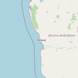
Map view of Velondriake

Use this park location map to pinpoint Velondriake in Madagascar, understand its exact geographic position, and read its mapped placement within the surrounding landscape more clearly.

Pigeon | © OpenStreetMap contributors
Park atlas

Compare adjacent marine reserves and regional conservation landscapes

Explore Parks Near Velondriake and Surrounding Coastal Protected Areas

Browse protected areas near Velondriake to examine connected coastal habitats and marine reserves across the surrounding region. Expanding the geographic comparison reveals broader patterns in community-led conservation and regional park geography.
Natural monumentAtsimo-Andrefana
About 122 km away#1 closest

Southeast

Analavelona Natural Monument: An Isolated Montane Forest Refuge in Southwestern Madagascar

Mapping a sacred and biodiverse massif in the Atsimo-Andrefana region

Analavelona Natural Monument represents a striking geographic contrast, standing as an elevated montane forest massif surrounded by arid plains. This protected landscape contains a complex ecological mosaic, ranging from humid evergreen forests to rocky sclerophyllous slopes. Recognized for its sacred status and high level of narrow-range endemism, the massif serves as an essential ecological island within the broader topography of southwestern Madagascar.

Area
44.87 km²
Established
2015
Relief
Mountain
Climate
Tropical
Nature reserveToliara Province
About 168 km away#2 closest

Northeast

Kirindy Forest Nature Reserve: Protected Dry Deciduous Forest in Western Madagascar

Geography, protected boundaries, and unique dry forest ecosystems

Kirindy Forest offers a detailed look into the ecology of western Madagascar. As a protected nature reserve, it shelters three species of baobab trees and diverse primate populations. Its terrain ranges from flat to gently undulating, creating a distinct visual rhythm through alternating dry and rainy seasons within the Menabe region.

Area
125 km²
Relief
Lowland
Climate
Tropical
Access
Moderate access
National parkMadagascar
About 168 km away#3 closest

Northeast

Kirindy Mitea National Park: Madagascar National Park with Distinct Protected Landscape Identity

Explore the mapped geographic context of Kirindy Mitea National Park.

Kirindy Mitea National Park serves as a notable protected area, holding national park status within Madagascar's distinctive island geography. This entry focuses on understanding the park's unique protected landscape and its charted boundaries, offering essential context for atlas-driven exploration. Discover the geographic elements that define Kirindy Mitea National Park and its place within the broader conservation map of the region.

Area
1,563.5 km²
Established
1997
IUCN
IV
Relief
Mixed relief
National parkAtsimo-Andrefana
About 172 km away#4 closest

Southeast

Zombitse-Vohibasia National Park: Protected Landscape and Regional Geographic Context

Mapped protected areas and natural terrain discovery.

Investigate Zombitse-Vohibasia National Park, a designated national park within the Atsimo-Andrefana region. This dedicated entry provides detailed geographic information, focusing on the park's mapped terrain and its contribution to the regional protected landscape. Gain insight into the park's atlas-relevant features and its specific place within Madagascar's conservation geography.

Area
363.08 km²
Established
2002
IUCN
II
Relief
Upland
National parkIhorombe Region
About 205 km away#5 closest

East

Isalo National Park: Explore Madagascar's Sandstone Canyons and Protected Landscape Geography

Discover unique geology, tapia woodlands, and regional park context.

Isalo National Park is a prominent protected area in Madagascar's Ihorombe Region, celebrated for its spectacular sandstone landscape. This national park features deep canyons, eroded rock domes, and striking runiform mountains, formed from ancient sedimentary deposits. The park preserves significant tapia woodlands and remarkable plant endemism, offering a rich context for understanding protected land distribution and Madagascar's unique geography. Its mapped terrain provides a visual atlas of natural wonders.

Area
815.4 km²
Established
1962
IUCN
II
Visitors
32.7K annual
National parkMadagascar
About 213 km away#6 closest

South

Tsimanampetsotsa National Park: National Park Protected Landscape and Geographic Features

Mapping the protected area boundaries and landscape context.

Delve into the protected landscape identity of Tsimanampetsotsa National Park, a designated national park. This profile focuses on its geographic significance, providing a clear view of its mapped boundaries and the surrounding natural terrain. Understand its role as a protected area within the larger atlas for comprehensive geographic exploration.

Area
432 km²
Established
1927
Relief
Mixed relief
Climate
Arid
National parkAtsimo-Andrefana
About 220 km away#7 closest

South

Tsimanampetsotsa National Park: A Geographic Overview of the Mahafaly Plateau and Spiny Forest

Protected landscapes and wetland geography in Southwestern Madagascar.

Located in the Atsimo-Andrefana region, Tsimanampetsotsa National Park protects a rare convergence of limestone sinkholes, salt-tolerant lake ecosystems, and ancient spiny forest thickets. This atlas record details the park's structural boundaries and its critical role as a site for plant endemism and prehistoric subfossil preservation within the broader Madagascar geographic context.

Area
432 km²
Established
1927
IUCN
II
Relief
Upland
Wildlife reserveAtsimo-Andrefana
About 223 km away#8 closest

Southeast

Beza Mahafaly Special Reserve: Atlas of the Gallery Forest and Dry Bush Landscape

Protected riparian ecosystems in the Atsimo-Andrefana region

Beza Mahafaly Special Reserve provides a concentrated look at Madagascar's rare gallery forest ecosystems. Situated within the dry, thorny spiny bush of the Atsimo-Andrefana region, the reserve protects a unique linear woodland environment. Its geography is characterized by the striking contrast between river-fed riparian corridors and the arid, undulating terrain that defines the southwestern landscape.

Area
6 km²
Established
1986
IUCN
IV

Common questions about visiting, size, designation, and location context for Velondriake

Velondriake FAQs for park facts, access, geography, and protected area context

Find quick answers about Velondriake, including protected-area facts, park geography, trail and visitor context, and how the park fits into its surrounding country and regional landscape.
MoriAtlas Explorer

Continue Your Protected Areas Search Across the Global Atlas

Deepen your exploration by continuing the structured search for national parks and protected areas worldwide. Utilize the comprehensive filtering capabilities to compare different conservation landscapes and refine your understanding of global park geography. Discover more about the distribution and characteristics of protected natural areas.

Global natural geography