
Mori Atlas logo
Nature reserveVereinigte Mulde Eilenburg – Bad Düben

Mapping the hydrological landscapes, riparian forests, and meadow ecosystems of the Mulde valley

Vereinigte Mulde Eilenburg – Bad Düben: A Comprehensive Protected River Floodplain in Saxony

(Naturschutzgebiet Vereinigte Mulde Eilenburg, Bad Düben)

The Vereinigte Mulde Eilenburg – Bad Düben nature reserve stands as a significant protected corridor within northern Saxony, safeguarding a continuous segment of the Mulde river valley. This lowland floodplain landscape features a complex mosaic of riparian woodland, aquatic channel structures, and seasonally influenced meadows shaped by regional hydrological dynamics. Serving as a functional habitat link between the Dübener Heide and the surrounding plains, the area offers insight into the characteristic river geography of central Germany.

river floodplainMulde valleySaxon nature reservelowland river ecosystemriparian forestfloodplain meadows
A stylized digital illustration of a mountainous valley with a winding river, pine forests, and a waterfall cascading down a cliff face under a soft, pastel-colored sky.

Vereinigte Mulde Eilenburg – Bad Düben

Nature reserve

Park overview

Structured park overview, official facts, and landscape profile for Vereinigte Mulde Nature Reserve Eilenburg, Bad Düben

Vereinigte Mulde Nature Reserve Eilenburg, Bad Düben park facts, protected area profile, and essential visitor context

Review the core facts for Vereinigte Mulde Nature Reserve Eilenburg, Bad Düben, including designation, size, terrain, visitor scale, habitats, and operating context in one park-focused overview.

About Vereinigte Mulde Nature Reserve Eilenburg, Bad Düben

Vereinigte Mulde Eilenburg, Bad Düben anchors a long stretch of protected floodplain along the Vereinigte Mulde in northern Saxony, between the spa town of Bad Düben and the historic town of Eilenburg. The reserve occupies roughly 1,453 hectares of lowland valley terrain, a scale that places it among the more substantial river-focused nature reserves in the region. As part of the Landkreis Nordsachsen protected area network, it complements neighbouring reserves such as Presseler Heidewald, Werbeliner See, and Paupitzscher See, together forming an interconnected system of natural areas in the Mulde, Elbe, and adjacent watersheds.

The landscape within the reserve reflects the typical character of a Central European river valley: a relatively flat alluvial corridor shaped by seasonal water flows, with riparian forests, wet meadows, and channel features arranged along the river's course. The Mulde itself is a defining geographic feature of the region, and within this protected segment it retains much of its natural floodplain structure, providing continuity for forest patches, herb-rich meadows, and aquatic habitats. The proximity of the Bad Düben spa park and the broader Dübener Heide landscape to the south adds contextual depth, while the open agricultural plains of northern Saxony frame the reserve's edges.

From an ecological perspective, the reserve addresses conservation priorities that hold true for similar river floodplain systems in central Germany: protecting riparian zoning, maintaining habitat connectivity along the river axis, and preserving the dynamic processes that define healthy lowland river environments. The IUCN Category IV designation confirms that active habitat and species management is part of the reserve's purpose, making its significance not only scenic but also ecological in a measurable sense. For visitors interested in quiet river-valley landscapes, Saxon natural heritage, or the broader Mulde river geography, the reserve represents a meaningful and accessible expression of these themes within the Sachsen protected area framework.

Quick facts and research context for Vereinigte Mulde Nature Reserve Eilenburg, Bad Düben

Vereinigte Mulde Eilenburg, Bad Düben is a Saxon nature reserve classified under IUCN Category IV as a Habitat and Species Management Area, managed specifically for biodiversity conservation. The reserve spans approximately 14.53 square kilometres of floodplain terrain in Landkreis Nordsachsen, with its official identifier recorded as NSG L 59 and its World Database on Protected Areas entry listed as 319254.

The area stretches along the Mulde river between Bad Düben in the south and Eilenburg in the north, bounded by the federal highways B 107, B 183, and B 87, alongside state road S 11. The protection designation traces back to 1997, with the formal nature reserve ordinance issued by the Leipzig regional government in December 2001, giving the area long-term legal standing within the Saxon protected area system.

Protection and recognition

Examine documented conservation parameters and official registry data for this protected area.

Vereinigte Mulde Eilenburg – Bad Düben Protection Status and Terrestrial Scope

Terrestrial protection status and administrative parameters outline the documented conservation framework for Vereinigte Mulde Eilenburg – Bad Düben. Official registry records organize baseline geographical attributes and designated management scope for structural analysis.

Protection details

Protection scope
Terrestrial
Transboundary protection
No
WDPA ID
319254
Park context

Deeper park guide and search-rich context for Vereinigte Mulde Nature Reserve Eilenburg, Bad Düben

Vereinigte Mulde Nature Reserve Eilenburg, Bad Düben history, landscape, wildlife, and travel context

Explore Vereinigte Mulde Nature Reserve Eilenburg, Bad Düben through its history, landscape character, ecosystems, wildlife, conservation priorities, cultural context, and seasonal travel timing in a structured park guide built for atlas discovery and search intent.

Why Vereinigte Mulde Nature Reserve Eilenburg, Bad Düben stands out

The reserve is best known for safeguarding a continuous stretch of the Mulde river floodplain, one of the natural hallmarks of northern Saxony. Where the Freiberger and Zwickauer Mulde merge to form the Vereinigte Mulde, this segment of the valley captures the hydrological character that supports the regional landscape's identity. Its protected mosaic of riparian woodland, flood meadows, and channel features reflects the ecological richness of intact Central European lowland river systems. The reserve also stands out within the Saxon network for its length, connecting the broader floodplain complex that runs through Landkreis Nordsachsen toward the Elbe basin.
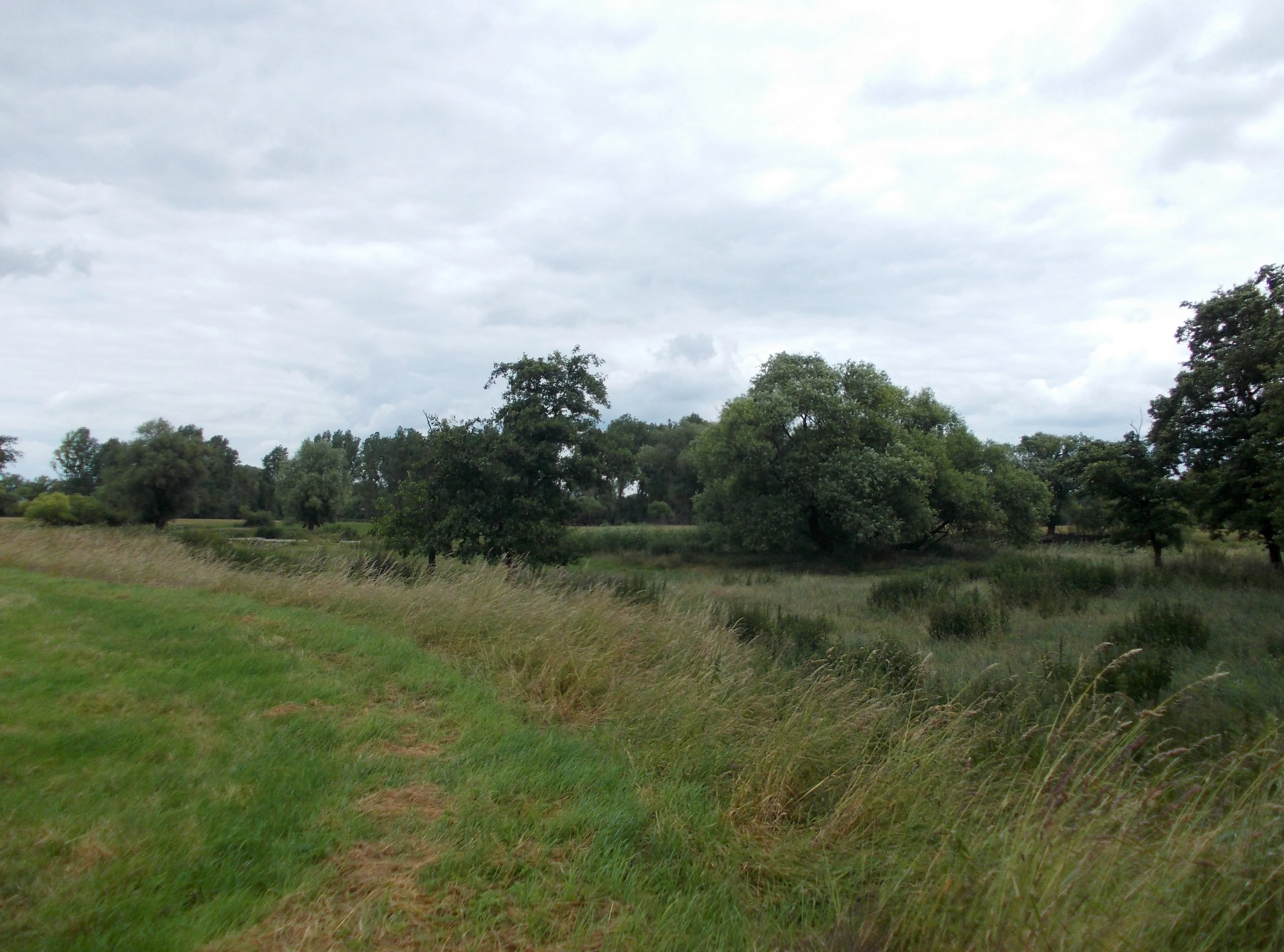
A wide view of a grassy meadow with scattered trees under an overcast sky, characteristic of the Mulde river floodplain.
The river landscape of the Mulde floodplain near Zschepplin.

Vereinigte Mulde Nature Reserve Eilenburg, Bad Düben history and protected-area timeline

Conservation recognition for the Vereinigte Mulde floodplain between Eilenburg and Bad Düben began in 1997, when the area was placed under Naturschutz in the state of Saxony. This initial step established the foundational protection framework for what would later become one of the more prominent floodplain reserves in northern Saxony.

In December 2001, the Regierungspräsidium Leipzig issued a formal ordinance to officially designate the area as a nature reserve under the designation Vereinigte Mulde Eilenburg, Bad Düben. The ordinance codified the protection boundaries, including the segment of the Mulde valley stretching across the municipalities of Bad Düben, Eilenburg, Doberschütz, Laußig, and Zschepplin.

The geographical placement, along a major Saxon river valley at the boundary with Sachsen-Anhalt, gave the reserve long-term significance within the regional conservation network. Its identification in international databases, including the World Database on Protected Areas under entry 319254, reflects its standing beyond regional protected area lists.

Vereinigte Mulde Nature Reserve Eilenburg, Bad Düben landscape and geographic character

The reserve's landscape is defined by the broad, flat floodplain of the Vereinigte Mulde, the unified river formed upstream by the merging of the Freiberger and Zwickauer Mulde. Within the protected segment between Bad Düben and Eilenburg, the alluvial valley displays the classic structure of a central German lowland river system, with the active river channel, floodplain meadows, oxbow features, and riparian forest zones arranged in a layered pattern along the watercourse.

The terrain is generally low-lying and shaped by the natural hydrology of the Mulde. Seasonal flooding and groundwater dynamics influence both the ground surface and the vegetation patterns, producing the mosaic of wet meadows, softwood floodplain forest, and herbaceous riverbank communities typical of intact river valleys in the region. Where the river bends, the protected area includes broader meander zones with characteristic floodplain features.

Beyond the river corridor itself, the surrounding region transitions into the wooded expanses of the Dübener Heide to the south and the more open agricultural plains of northern Saxony and Sachsen-Anhalt to the north and east. This contrast, dense forest south of the reserve and open farmland beyond its boundaries, frames the floodplain as a distinctive ecological ribbon through an otherwise partly settled landscape.

Vereinigte Mulde Nature Reserve Eilenburg, Bad Düben ecosystems, habitats, and plant life

The reserve protects a representative slice of central European river floodplain ecology, anchored by the Vereinigte Mulde and its associated alluvial habitats. The vegetation reflects the gradient between open water, softwood floodplain forest, wet meadows, and drier ruderal zones established where former floodplain land lies further from the active channel.

Riparian woodland is one of the defining habitat types within the protected area, taking advantage of the nutrient-rich soils laid down by the Mulde over time. These forests play a central role in stabilising banks, supporting aquatic life, and maintaining the mosaic pattern characteristic of natural floodplain systems in Saxony. Open flood meadows contribute additional structural variety, supporting herbaceous communities that depend on periodic flooding and natural disturbance cycles.

As an IUCN Category IV Habitat and Species Management Area, the reserve is explicitly recognised for its role in conserving habitats and species associated with the Mulde floodplain. The inclusion of the reserve in the World Database on Protected Areas signals that it is treated as part of Germany's broader catalogue of significant biodiversity conservation areas, even within a regional context dominated by larger forested landscapes like the Dübener Heide.

Vereinigte Mulde Nature Reserve Eilenburg, Bad Düben wildlife and species highlights

The Mulde floodplain habitats hosted by the reserve support characteristic central European lowland wildlife, including bird, fish, and insect species linked to the river and its associated riparian landscape. Floodplain forests and meadows along a large river like the Vereinigte Mulde typically provide breeding and foraging habitat for riparian bird species, while the river itself supports fish populations and aquatic fauna typical of Saxon lowland waterways.

The reserve's length and continuity along the river valley also makes it ecologically meaningful beyond its immediate boundaries: it provides a contiguous habitat corridor through northern Saxony, allowing species movement along the river axis between upstream and downstream areas, including toward the Elbe basin to the north.

While the source material does not provide specific species inventories, the reserve's status as an IUCN Category IV management area, combined with its location within the Mulde valley and the regional Sachsen-Anhalt border corridor, points to its broader relevance as a habitat anchor for floodplain-associated species and migration routes characteristic of northern Saxony.

Vereinigte Mulde Nature Reserve Eilenburg, Bad Düben conservation status and protection priorities

Vereinigte Mulde Eilenburg, Bad Düben is recognised under IUCN Category IV as a Habitat and Species Management Area, a designation that reflects its purpose of actively maintaining habitats and species rather than serving primarily as a strictly protected wilderness zone. The reserve's inclusion in the World Database on Protected Areas under record 319254 confirms its standing within Germany's national and international protected area reporting systems.

The conservation significance of the reserve lies in its protection of an extended segment of the Mulde floodplain, a landscape type that has been reduced and fragmented across many parts of central Germany. By securing a continuous, regulated corridor through Landkreis Nordsachsen, the reserve contributes to preserving both the structural integrity of the floodplain and its role as a habitat connector across the broader regional landscape.

The 2001 ordinance by the Regierungspräsidium Leipzig codified this conservation role, providing legal protection against development and unregulated land use. Within Saxony's network of nature reserves, the Vereinigte Mulde reserve stands out for its size, linear character, and connection to the state's principal river systems, reinforcing the importance of floodplain conservation alongside the region's more forest-dominated protected areas.

Vereinigte Mulde Nature Reserve Eilenburg, Bad Düben cultural meaning and human context

The reserve sits within a region shaped by centuries of interaction between rivers and human settlements along the Mulde valley. The neighbouring towns of Bad Düben, a historic spa town recognised for its salt springs, and Eilenburg, a settlement with medieval roots near the Mulde, frame the protected area within a cultural landscape where river valleys have long supported agricultural, recreational, and small-scale industrial uses.

The protected floodplain today provides a counterpoint to the surrounding cultural landscape, preserving natural river dynamics that have otherwise been altered in many sections of central German lowland rivers. This places the reserve in a meaningful regional context: a natural anchor within a working Saxon countryside that bridges the wooded Dübener Heide and the wider Saxon lowland.

Top sights and standout views in Vereinigte Mulde Nature Reserve Eilenburg, Bad Düben

The reserve's standout features centre on the integrity and continuity of the Mulde floodplain, which forms a substantial protected corridor through northern Saxony. Its IUCN Category IV classification adds a layer of functional conservation relevance, recognising it as an actively managed habitat area rather than a passive landscape.

Together with neighbouring Saxon reserves such as Presseler Heidewald, Werbeliner See, and Paupitzscher See, the Vereinigte Mulde reserve contributes to a connected network of protected areas across Landkreis Nordsachsen. For visitors interested in Saxon river geography, lowland floodplain ecology, or quieter protected natural areas outside Germany's more famous national parks, this reserve offers a substantial and informative example.

Best time to visit Vereinigte Mulde Nature Reserve Eilenburg, Bad Düben

The Vereinigte Mulde floodplain environment changes considerably across the seasons, with each period offering a distinct character. Spring typically brings rising water levels and fresh green growth across the meadows and riparian forest, while summer offers dense vegetation and active birdlife along the river corridor. Higher water tables in late winter and during periods of snowmelt can shape the floodplain's surface conditions and accessibility.

Because the reserve is a low-lying floodplain linked to a major river system, conditions can shift quickly with weather and seasonal hydrology. For visitors interested in observing the floodplain's natural dynamics rather than formal visitor infrastructure, late spring and early autumn often provide balanced conditions for landscape viewing and quiet nature observation.

Monthly climate preview

Long-term representative temperature and precipitation averages recorded across twelve monthly intervals.

Vereinigte Mulde Eilenburg – Bad Düben Climate Normals and Annual Weather Patterns

Representative coordinate records show measured monthly temperature ranges and precipitation rates spanning a multi-year climatology period for Vereinigte Mulde Eilenburg – Bad Düben. Detailed monthly comparisons provide broader analytical context for long-term meteorological normals across the regional terrain.
Annual mean9 °C
-1 °C20 °C
Jan-1°
Feb
Mar
Apr
May14°
Jun18°
Jul20°
Aug20°
Sep15°
Oct
Nov
Dec
Warmest month
July

19.7 °C

Coolest month
January

-0.5 °C

Wettest month
July

2.5 mm/day

Driest month
April

1.1 mm/day

Park location guide

Geography guide, regional context, and park location map for Vereinigte Mulde Nature Reserve Eilenburg, Bad Düben

Vereinigte Mulde Nature Reserve Eilenburg, Bad Düben park geography, regions, and map view in Germany

Understand where Vereinigte Mulde Nature Reserve Eilenburg, Bad Düben sits in Germany through a broader geographic reading of the surrounding landscape, nearby location context, and its mapped position within the national park landscape.

How Vereinigte Mulde Nature Reserve Eilenburg, Bad Düben fits into Germany

Germany is a federal republic in Western and Central Europe with a population of over 83 million across sixteen constituent states. It is Europe's largest economy by nominal GDP and a major global exporter and importer. The capital is Berlin, and the country borders Denmark, Poland, Czech Republic, Austria, Switzerland, France, Luxembourg, Belgium, and the Netherlands.

Wider geography shaping Vereinigte Mulde Nature Reserve Eilenburg, Bad Düben in Germany

Germany is located in Western and Central Europe, spanning 357,022 km². It borders Denmark to the north, Poland and the Czech Republic to the east, Austria and Switzerland to the south, and France, Luxembourg, Belgium, and the Netherlands to the west. The country has coastlines on the Baltic Sea and North Sea to the north, with the Alps located in the southern region.

Map view of Vereinigte Mulde Nature Reserve Eilenburg, Bad Düben

Use this park location map to pinpoint Vereinigte Mulde Nature Reserve Eilenburg, Bad Düben in Germany, understand its exact geographic position, and read its mapped placement within the surrounding landscape more clearly.

Pigeon | © OpenStreetMap contributors

Location context for Vereinigte Mulde Nature Reserve Eilenburg, Bad Düben

Saxony

Visualizing riparian forests, river floodplains, and protected habitats

Vereinigte Mulde Eilenburg – Bad Düben Photos and Landscape Scenery

Visual documentation captures the lowland river ecosystems, riparian woodlands, and meandering waterways that define the protected landscape. Examining these field photographs reveals the terrain structures and floodplain habitats characteristic of the central German river corridor.

A wide view of a grassy meadow with scattered trees under an overcast sky, characteristic of the Mulde river floodplain.

Park atlas

Compare regional lowland river landscapes and adjacent conservation corridors

Explore Protected Areas and Parks Near Vereinigte Mulde Eilenburg – Bad Düben

Discover related protected areas and surrounding valley reserves that share the ecological traits of Vereinigte Mulde Eilenburg – Bad Düben. Comparing adjacent lowland river networks reveals broader geographic patterns across northern Saxony.
A soft watercolor painting of a green, marshy landscape with a winding waterway and rolling hills in the background.
Nature reserveSaxony
About 26 km away#1 closest

East

Großer Teich Torgau: A Protected Saxon Reservoir and Historic Wetland Map

Exploring the medieval pond culture and nature reserve boundaries in Saxony

Located in northern Saxony, Großer Teich Torgau is a rare surviving medieval fish pond that functions as a nature reserve and flood management reservoir. This protected landscape contains shallow water zones, historic earthen dam structures, and surrounding marshlands that illustrate centuries of continuous human and natural interaction within the regional geography.

Area
1.75 km²
Established
1484
Relief
Lowland
Scope
Terrestrial
A soft watercolor painting depicting a serene floodplain forest with trees, grasses, and a winding stream, rendered in light green and muted tones.
Nature reserveLeipzig
About 28 km away#2 closest

Southwest

Burgaue Nature Reserve: Alluvial Forest and Hydrological Geography in Leipzig, Germany

Protected floodplain woodland and restored wetland corridors.

Burgaue is a distinctive nature reserve forming the northwestern anchor of the Elster Luppe floodplain. This urban-adjacent protected area preserves a complex topography of historic river channels, wet depressions, and hardwood forest. Through recent hydrological restoration, the landscape maintains its status as a vital riparian habitat and a significant element of the regional Saxon environment.

Area
2.7 km²
Established
1367
Relief
Lowland
Climate
Temperate
A horizontal watercolor illustration showing soft green rolling hills, trees, and a pale yellow sky.
Nature reserveSaxony
About 33 km away#3 closest

South

Alte See, Ruhmberg Nature Reserve: Geographic Atlas of a Protected Landscape in Saxony

Ecological recovery of former military sites in the German lowlands.

Situated in the Landkreis Leipzig, the Alte See, Ruhmberg nature reserve offers a complex study in land use and conservation. The protected area features a unique transition between alder carr wetlands along the Parthe river and the dry, open grasslands of the Ruhmberg hill, creating a high-density biodiversity hotspot within the broader context of Saxon geography.

Area
2.66 km²
Established
2015
IUCN
IV
A horizontal watercolor painting showing a tranquil lake with soft green hills and sparse vegetation along the shoreline under a pale, warm sky.
Nature reserveSachsen
About 45 km away#4 closest

South

Bockwitz Nature Reserve: Mapping the Industrial Reclamation Landscapes of Sachsen, Germany

A Protected Mosaic of Rewetted Lakes and Mining Follow-on Terrain

Spanning 545 hectares, the Bockwitz nature reserve offers a unique look at the transformation of former lignite opencast pits into a thriving wetland habitat. The protected area is characterized by its significant residual water bodies, including Bockwitzer See and the Südkippe pit, which showcase the evolution of Sachsen landscape geography following industrial decline. This site serves as a vital example of habitat management within an anthropogenic environment.

Area
5.454 km²
Established
2003
IUCN
IV
Water
Major water bodies
Nature reserveBrandenburg
About 47 km away#5 closest

East

Alte Elster und Rieke: Protected Floodplain and River Geography in Brandenburg

Nature reserve featuring old river arms and wetland mosaics.

The Alte Elster und Rieke nature reserve represents one of the few surviving near-natural floodplain remnants along the Schwarze Elster river. This area supports a rich network of ponds, reed beds, and wet meadows that serve as a crucial refuge for wetland plants and wildlife within the otherwise heavily regulated Elbe-Elster lowland landscape.

Area
1.756 km²
Established
1981
IUCN
IV
Relief
Lowland
Nature reserveSachsen
About 48 km away#6 closest

Southeast

Scheergrund Nature Reserve: Geographic Atlas and Protected Landscape Overview

Mapping the geology and woodland history of the Leisnig region

Scheergrund functions as a vital nature reserve and geological reference site within the Saxon landscape. This area provides insight into Holocene tufa systems, ancient dam structures, and the complex interplay between spring-fed stream morphology and human development in the Freiberger Mulde tributary valley.

Area
0.578 km²
Established
1961
IUCN
IV
A soft watercolor painting depicting a pale, hazy landscape with green grassy fields, light green trees, and distant faint mountains under a pastel sky.
Protected areaSaxony
About 49 km away#7 closest

East

Gohrischheide und Elbniederterrasse Zeithain: Geography and Protected Area Overview

Analyzing the inland dunes and dry heath landscape of the Elbe river terrace

Discover the unique geography of Gohrischheide und Elbniederterrasse Zeithain in Saxony, a protected area known for its expansive inland dunes and dry heath habitats. This region represents a rare combination of post-glacial sand landscapes and semi-open forest mosaics that reflect long-term ecological evolution and distinct regional environmental conditions.

Area
28.47 km²
Established
2011
Relief
Lowland
Climate
Temperate
A horizontal watercolor painting showing a soft, atmospheric wetland scene with green meadows, tall grasses, distant tree lines, and a pale pink and yellow sky.
Nature reserveBrandenburg
About 51 km away#8 closest

East

Kleine Röder Nature Reserve: Mapped Wetland Geography and Protected Landscape in Brandenburg

A vital Elbe-Mulde lowland corridor near Bad Liebenwerda

The Kleine Röder Nature Reserve functions as a major ecological link in northeastern Germany, protecting a 385 hectare mosaic of fens, wet meadows, and alluvial forests. This site is defined by its water-dominated terrain and its role as a habitat corridor in the Elbe-Mulde lowland, encompassing both rare wetland flora and the historic Kosilenzien Slavic ringwall within its official boundaries.

Area
3.65 km²
Established
2011
IUCN
IV

Common questions about visiting, size, designation, and location context for Vereinigte Mulde Nature Reserve Eilenburg, Bad Düben

Vereinigte Mulde Nature Reserve Eilenburg, Bad Düben FAQs for park facts, access, geography, and protected area context

Find quick answers about Vereinigte Mulde Nature Reserve Eilenburg, Bad Düben, including protected-area facts, park geography, trail and visitor context, and how the park fits into its surrounding country and regional landscape.
MoriAtlas Explorer

Continue Your Protected Areas Search Across the Global Atlas

Deepen your exploration by continuing the structured search for national parks and protected areas worldwide. Utilize the comprehensive filtering capabilities to compare different conservation landscapes and refine your understanding of global park geography. Discover more about the distribution and characteristics of protected natural areas.

Global natural geography