
Mori Atlas logo
Nature reserveViehmoor

Mapping the ecological mosaic of wetlands, heath, and woodland in the Gifhorn district

Viehmoor Nature Reserve: Protected Lowland Mire and Inland Dune Geography in Lower Saxony

(Naturschutzgebiet Viehmoor)

Viehmoor represents a significant protected nature area in Lower Saxony, characterized by its tightly compressed landscape of lowland mires, inland dunes, and former fishponds. This mapped record provides a comprehensive view of the reserve's unique environmental mosaic, spanning wet grasslands, alder carr, and broom heath transitions. Analyze the terrain and boundaries of this long-standing refuge for diverse bird species and wetland-dependent ecosystems.

nature reservewetlandlowland mireNiedermoorpeatlandinland dunes
A flat vector-style illustration of a dramatic landscape featuring a central waterfall cascading between tall rocky cliffs, with a foreground stream, marshy vegetation, and scattered trees under a pale sky.

Viehmoor

Nature reserve

Park overview

Structured park overview, official facts, and landscape profile for Viehmoor

Viehmoor park facts, protected area profile, and essential visitor context

Review the core facts for Viehmoor, including designation, size, terrain, visitor scale, habitats, and operating context in one park-focused overview.

About Viehmoor

Viehmoor is a nature reserve in the northern German state of Lower Saxony, situated on the geest landscape southwest of Gifhorn. Covering about 302 hectares across parts of the municipalities of Leiferde and Ribbesbüttel, it is a textbook example of the kind of protected habitat mosaic common to the south of the Lüneburg Heath region: a low-lying wetland basin surrounded by wind-shaped sand deposits, bordered by dry heath and mixed woodland, and embedded within a broader countryside that includes fishponds, meadows, and relict peat workings.

The reserve sits within a quiet rural part of the Landkreis Gifhorn, just east of Leiferde and roughly midway between the district's larger settlements. Its location on the groundwater-rich geest has shaped its ecological character: where fine sediment was scoured away during the last glaciation, a flat and waterlogged basin remained, while coarser sand was heaped at the edges into a dune ridge, providing sharply contrasting dry and wet conditions in close proximity.

What makes Viehmoor distinctive as a protected area is precisely this juxtaposition. The western part of the reserve contains a series of former fishponds, now characterized by shallow zones of sedimentation and reed growth, while the southern part is dominated by extensive wet to moist grassland. Open water, marsh vegetation, peat-moss quaking mats, sedge communities, and alder carr woodland each occupy their own niches. On the drier dune soils, broom heath and scattered pines have established themselves, with mixed forest growing on the most prominent dune ridges to the north and east.

This landscape is ecologically significant because it preserves a connected chain of habitats that are increasingly rare in intensively used northern Germany. The site is recognized for breeding and migratory bird populations, and for the many plant and animal species that depend on the specific conditions of dunes, mires, and wetlands. Its protected status, secured in 1979, reflects a long-standing effort by regional conservationists and volunteer groups, notably the local NABU chapter, which maintains the area through volunteer stewardship and runs an associated species protection center at the edge of Leiferde.

Quick facts and research context for Viehmoor

Viehmoor is a 302-hectare nature reserve located in the Landkreis Gifhorn in Lower Saxony, between the communities of Leiferde and Ribbesbüttel. The reserve carries the official designation NSG BR 018 and has been protected since 2 August 1979, with the Landkreis Gifhorn serving as the responsible lower nature protection authority.

Geologically, the area is the product of the last ice age: fine soil was blown out of a shallow basin, leaving a wet lowland that became a Niedermoor (lowland mire), while coarser sand accumulated at the margins as inland dunes reaching about three meters in height. Management responsibility is held through the regional water and nature authority, and the area is nearly surrounded by a broader landscape protection zone, situating Viehmoor within a wider network of heaths and associated habitats in the district.

Protection and recognition

Documented conservation frameworks and official designation records

Viehmoor Protection Status and International Recognition Data

Viehmoor brings together verified protection status, designation history, and management scope within a structured database record. Official records outline international recognition data and administrative context for this protected natural area.

Protection details

WDPA ID
82781
Park context

Deeper park guide and search-rich context for Viehmoor

Viehmoor history, landscape, wildlife, and travel context

Explore Viehmoor through its history, landscape character, ecosystems, wildlife, conservation priorities, cultural context, and seasonal travel timing in a structured park guide built for atlas discovery and search intent.

Why Viehmoor stands out

Viehmoor is best known for its concentration of birdlife, functioning as both a breeding area and a stopover site for waterbirds and species tied to heath, mire, and open wetland habitats. The reserve's combination of wet lowland, fishponds with marginal reed belts, and dune-heath transitions creates a varied ecological patchwork within a relatively compact footprint.
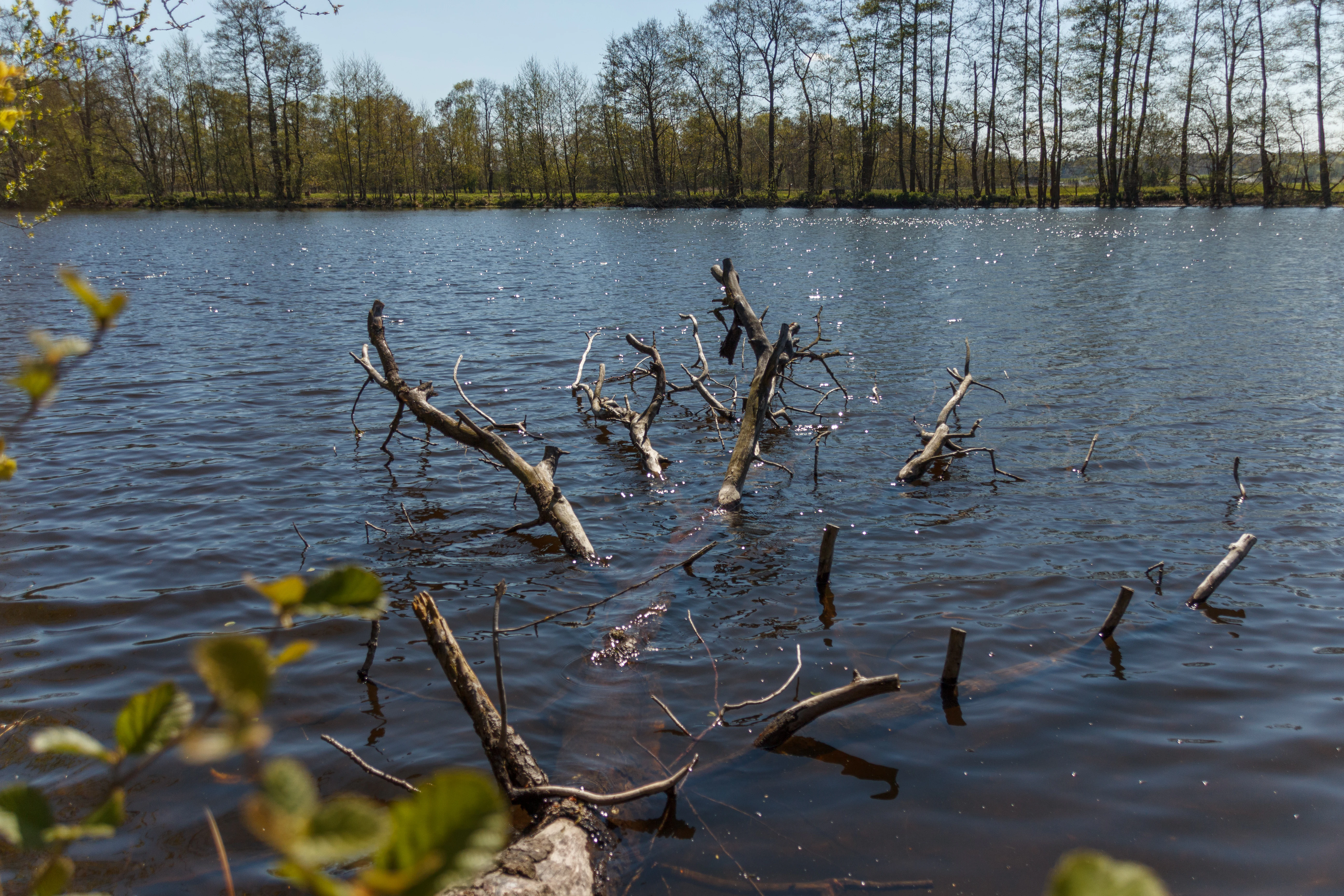
A view of a calm lake in the Viehmoor nature reserve with a partially submerged tree branch in the foreground and a line of trees on the opposite bank under a clear blue sky.
A serene view of a calm wetland pond in the Viehmoor nature reserve, featuring submerged branches in the foreground.

Viehmoor history and protected-area timeline

Viehmoor was officially placed under nature protection (Naturschutzgebiet) on 2 August 1979, under the designation NSG BR 018. The protection formalizes the site's existing ecological value rather than creating a new reserve from scratch; its fishponds, peat-cutting hollows, and traditional land use had shaped the landscape long before designation.

Protection is administered through the Landkreis Gifhorn as the responsible lower nature protection authority, with the broader Niedersächsischer Landesbetrieb für Wasserwirtschaft, Küsten- und Naturschutz (NLWKN) providing regional coordination. The reserve is almost entirely encircled by the larger landscape protection area (Landschaftsschutzgebiet) known as Gifhorner, Winkeler und Fahle Heide and surrounding landscape parts, situating Viehmoor within a wider protection framework.

Conservation management has involved active stewardship rather than passive protection. The NABU Kreisverband Gifhorn, working through a volunteer group known as the Viehmoor-AG, has carried out ongoing habitat management work, while the NABU's species protection center at Leiferde runs guided tours into the reserve. Although the reserve today is associated with conservation, its southwestern boundary adjoins an active petroleum extraction area, illustrating the spatial tension between protection and resource use that is typical of many reserves in this part of Lower Saxony.

Viehmoor landscape and geographic character

Viehmoor's terrain is shaped directly by its glacial and postglacial history. During the last ice age, fine soil material was blown out of a shallow basin, leaving behind a flat, waterlogged lowland where a small raised-style mire could form. The sand that was carried away accumulated instead at the edges, building up an inland dune ridge that encloses the mire to the north and east and rises about three meters above the surrounding terrain.

Within this setting, the landscape divides into clearly distinct zones. The western part of the reserve is governed by a chain of seven former fishponds covering roughly 36 hectares, where shallowing waters have produced reedbeds and fine sediment zones along the margins. The southern part is dominated by broad meadow areas, some only seasonally moist, others persistently damp, while the central hollows contain peat-moss quaking mats and sedge beds growing in the abandoned peat cuttings (Torfstich).

Around the edges, the drier environment of the dunes supports a different kind of landscape: patches of broom heath accented by solitary pines, mixed forest on the more stable ridges, and alder carr woodland along the wetter margins. The result is an unusually compressed landscape mosaic for an area of this size, with dry heath, woodland, open water, reed marsh, wet grassland, and mire all lying within walking distance of one another.

Viehmoor ecosystems, habitats, and plant life

The ecological character of Viehmoor is built on the coexistence of mire, wetland, and dry heath in a single reserve. Its Niedermoor, or lowland mire, sits in a groundwater-rich part of the geest and supports peat-forming plant communities, including peat moss (Sphagnum) mats that form floating quaking vegetation (Schwingrasen) over the old peat cuttings, and dense beds of bottle sedge (Schnabel-Segge).

On the margins and dunes, the ecological register shifts sharply. Here, broom heath communities have colonized the sandy soils, interspersed with single pines that give the dry areas a characteristic sparse cover. The dune ridges themselves, where soils are more stable, host mixed woodland, while along the interfaces between wet and dry zones, alder carr woodland has developed on the dampest sites.

The mosaic of open water, transitional reed marsh, wet grassland, and dry heath provides the ecological foundation for Viehmoor's importance to fauna. It is the combination of habitats, not the dominance of any single one, that explains why the reserve supports such an unusual range of species for a comparatively small protected area in intensively farmed Lower Saxony.

Viehmoor wildlife and species highlights

Viehmoor has been recognized primarily for its birdlife. The reserve functions as both a breeding area and a seasonal stopover for a wide variety of bird species, taking advantage of the range of habitats on offer: open water and reed for waterbirds, wet grassland for meadow-nesting species, and the heath, woodland, and dune edges for species tied to drier or more structurally varied terrain.

The site has particular value as a refuge for species associated with dunes, lowland mires, and wetlands, including plants and animals that have become scarce elsewhere in the surrounding agricultural landscape. Detailed surveys of the area's non-passerine birds have been published in regional ornithological literature, reflecting the level of interest the reserve commands among birders and conservation biologists.

Beyond birds, the combination of habitats supports a broader community of wetland-, mire-, and heath-dependent fauna, which is a key reason why the NABU operates a dedicated species protection center adjacent to the reserve at Leiferde and runs guided tours into the area from there.

Viehmoor conservation status and protection priorities

Viehmoor matters for conservation because it preserves, within a single contiguous protected area, several interconnected habitat types that have become increasingly fragmented in the wider north German countryside. The reserve's mosaic of inland dunes, broom heath, mixed woodland, lowland mire, peat-cutting pools, fishpond reedbeds, and wet grassland makes it functionally richer than its modest size suggests.

Protection has been in place since 1979 and is layered: the core is the Naturschutzgebiet status, and it is nearly entirely encircled by a Landschaftsschutzgebiet, extending protection into a wider buffer of heaths and farmland. The reserve is classified under the IUCN framework as a Habitat/Species Management Area (Category IV), reflecting its management orientation rather than strict non-intervention.

Management is active rather than purely protective. The local NABU association, through its Viehmoor volunteer working group, runs regular stewardship tasks on the ground. The NABU's Artenschutzzentrum Leiferde on the edge of the village focuses on species conservation and provides guided access to the reserve. At the same time, the southwestern boundary of the reserve borders an active petroleum extraction area, illustrating the ongoing challenge of balancing conservation, traditional land use, and resource extraction in the region.

Viehmoor cultural meaning and human context

The cultural context of Viehmoor is tied primarily to long-standing rural land use. The ponds in the western part of the reserve have their origins in former fish farming, while the peat-cutting hollows scattered across the mire reflect historical turf extraction for fuel and horticulture. These human uses shaped the surface of the reserve and continue to define much of its visible character, particularly the open water and quaking peat-moss mats of the central zone.

Today, the reserve is integrated into local civic life through the activities of the Naturschutzbund Deutschland, which operates a species protection center at Leiferde and uses it as a base for volunteer habitat management and guided public tours. The reserve is thus not only a habitat reserve but also a community-facing conservation site, where farming heritage, modern environmental stewardship, and public engagement come together.

Top sights and standout views in Viehmoor

Viehmoor's principal distinguishing feature is its tightly compressed mosaic of contrasting habitats: a lowland mire encircled by inland dunes, with fishpond reedbeds, wet grasslands, peat-cutting pools, broom heath, and mixed woodland all within a few hundred meters of one another. This the reserve a markedly richer conservation profile than its roughly 302-hectare footprint would suggest.

The reserve's second major highlight is its ornithological importance, with both breeding and migratory birds finding suitable habitat across the spectrum of conditions, supported by adjacent NABU-led volunteer work and a dedicated species protection center on the reserve's edge. The site's protected status since 1979 and its near-complete enclosure within a larger landscape protection area further reinforce its role as a long-standing refuge for wetland and heath-dependent wildlife within the Gifhorn district.

Best time to visit Viehmoor

Viehmoor is a habitat whose character shifts meaningfully across the seasons. Spring and early summer are the most active periods for breeding birds, when the wet meadows, reedbeds, and open water are at their most visible and the heath margins are in bloom. Late summer and autumn can be excellent for migratory waterbirds and passage species using the reserve as a stopover, while winter reveals the open structure of the dunes, heath, and partly drained meadows, when waterfowl may still be present and visibility across the open areas is greatest.

Because the reserve is managed rather than purely wilderness, the best visiting experience tends to come through guided walks organized from the NABU Artenschutzzentrum at Leiferde, which can direct visitors to the parts of the reserve most worth seeing at any given time of year. Casual visitors should treat the area as a working conservation site rather than a recreational landscape, and plan visits accordingly.

Monthly climate preview

Measured annual weather by month for a representative coordinate in Lower Saxony

Viehmoor Climate Normals, Long Term Temperature and Precipitation Patterns

Representative point measurements track the long term monthly temperature and precipitation rhythm across Viehmoor from 1991 to 2020. Accessing the complete twelve month climate profile reveals full statistical variations across all recorded intervals.
Annual mean9 °C
0 °C19 °C
Jan
Feb
Mar
Apr
May13°
Jun17°
Jul19°
Aug18°
Sep14°
Oct
Nov
Dec
Warmest month
July

18.6 °C

Coolest month
January

0.2 °C

Wettest month
July

2.6 mm/day

Driest month
April

1.4 mm/day

Park location guide

Geography guide, regional context, and park location map for Viehmoor

Viehmoor park geography, regions, and map view in Germany

Understand where Viehmoor sits in Germany through a broader geographic reading of the surrounding landscape, nearby location context, and its mapped position within the national park landscape.

How Viehmoor fits into Germany

Germany is a federal republic in Western and Central Europe with a population of over 83 million across sixteen constituent states. It is Europe's largest economy by nominal GDP and a major global exporter and importer. The capital is Berlin, and the country borders Denmark, Poland, Czech Republic, Austria, Switzerland, France, Luxembourg, Belgium, and the Netherlands.

Wider geography shaping Viehmoor in Germany

Germany is located in Western and Central Europe, spanning 357,022 km². It borders Denmark to the north, Poland and the Czech Republic to the east, Austria and Switzerland to the south, and France, Luxembourg, Belgium, and the Netherlands to the west. The country has coastlines on the Baltic Sea and North Sea to the north, with the Alps located in the southern region.

Map view of Viehmoor

Use this park location map to pinpoint Viehmoor in Germany, understand its exact geographic position, and read its mapped placement within the surrounding landscape more clearly.

Pigeon | © OpenStreetMap contributors

Location context for Viehmoor

Lower Saxony

Visual exploration of lowland mires, inland dunes, and wetland habitats in Lower Saxony

Viehmoor Photos and Protected Landscape Scenery

Photographic views document the compressed ecological mosaic of Viehmoor, capturing groundwater-fed mires, fishpond reedbeds, and surrounding inland dune ridges. Visual documentation provides essential context for understanding how dry heath and wet grassland transitions support diverse regional birdlife.

A view of a calm lake in the Viehmoor nature reserve with a partially submerged tree branch in the foreground and a line of trees on the opposite bank under a clear blue sky.

A landscape view of a grassy path beside a drainage ditch in Viehmoor nature reserve, with fields, shrubs, and trees under a clear blue sky.

Park atlas

Discover related reserves, regional geography, and connected lowland habitats

Explore Parks Near Viehmoor and Surrounding Protected Landscapes

Compare Viehmoor with other protected areas across the surrounding district and neighboring wetland terrain. Broaden your geographic exploration by examining connected lowland mires, inland dune reserves, and regional wildlife habitats.
Nature reserveLower Saxony
About 18 km away#1 closest

Southwest

Wendesser Moor Nature Reserve: Mapped Wetland Geography and Protected Landscape Context in Lower Saxony

Exploring the peatland mosaic and marsh bird habitats of the Peine district

Wendesser Moor is a significant 63-hectare nature reserve in Lower Saxony, defined by its rare concentration of fen habitats, alder carr, and open peat pools. As a core component of a wider landscape protection zone, it provides essential refuge for threatened bird species. The reserve functions as a critical node in the local watershed, illustrating how small-scale protected peatlands maintain biodiversity in agricultural lowlands.

Area
0.632 km²
Established
1973
IUCN
IV
Relief
Lowland
Nature reserveLower Saxony
About 22 km away#2 closest

Northeast

Vogelmoor Nature Reserve: Geographic Map and Protected Wetland Landscape in Lower Saxony

Birch bog forests, peat ponds, and rare mire habitats

Vogelmoor offers a deep look into the glacial topography of northern Germany. As a core protected area within the Gifhorn district, this site features a diverse assembly of sphagnum-rich forest, floating mats, and open heath. The reserve stands as a critical example of landscape restoration within a heavily agricultural region, providing essential refuge for wetland bird species and specialized bog vegetation.

Area
1.335 km²
Established
1974
IUCN
IV
Protected landscapeLower Saxony
About 23 km away#3 closest

Southeast

Weddeler Teich Protected Landscape: Wetland Geography and Regional Map Context

A mapped nature reserve in the Lower Saxony lowlands

Weddeler Teich is a protected landscape in Lower Saxony characterized by its shallow, nutrient-rich basin and extensive reed vegetation. This wetland reserve acts as a critical refuge for bird species, standing out as a verdant marshy pocket within the wider cultivated agricultural plains east of Braunschweig.

Area
0.2 km²
Established
1981
Relief
Lowland
Climate
Temperate
Nature reserveNiedersachsen
About 27 km away#4 closest

East

Wendschotter und Vorsfelder Drömling mit Kötherwiesen: Protected Peatlands and Floodplains

Niedersachsen lowland geography and wetland habitat mapping

Spanning over 700 hectares in Wolfsburg, this nature reserve protects a complex network of marshes, reedbeds, and alluvial meadows. This atlas-focused overview examines the reserve's historic ditch systems, river corridors, and its role as a core component of the regional Drömling ecological network.

Area
7.22 km²
Established
2020
Relief
Lowland
Climate
Temperate
Nature reserveLandkreis Helmstedt
About 31 km away#5 closest

East

Südlicher Drömling: Protected Floodplain Landscapes in Landkreis Helmstedt

Wetland nature reserve and alluvial forest geography

Südlicher Drömling represents a critical protected wetland area defined by the Aller river floodplain. The landscape provides a study in successional dynamics, featuring old-growth alluvial forests, species-rich wet meadows, and temporary open-water pools during seasonal flooding periods. It stands as an important regional anchor for migratory bird species and floodplain restoration within the broader Drömling basin.

Area
6.02 km²
Established
2018
Watercolor illustration of a peaceful landscape featuring distant rolling hills, clusters of trees on the right, and a river or stream winding through a grassy plain against a pale background.
Protected landscapeLower Saxony
About 31 km away#6 closest

Southeast

Dorm Protected Landscape: Geological Ridge and Forested Geography in Lower Saxony

Mapping the natural terrain and forest ecosystems of the East Brunswick hill country

Defined by its narrow anticline structure and diverse woodland mosaics, the Dorm stands as a vital protected area in Lower Saxony. This overview examines the ridge's geological composition, including its Triassic sandstone formations, saline habitats, and significant doline pools that characterize this prominent East Brunswick landmark.

Area
6.89 km²
Established
2020
Relief
Upland
Climate
Temperate
Nature reserveSalzgitter
About 39 km away#7 closest

South

Tagebau Haverlahwiese Nature Reserve: Geography and Protected Area Mapping in Salzgitter

Mapping restored post-industrial landscapes and habitat mosaics.

This protected area in Salzgitter showcases the natural recovery of former ironstone mining lands. Users can examine the spatial arrangement of the 15-hectare mining lake, extensive reedbeds, and dry calcareous grassland slopes. The site remains a vital example of landscape conservation, illustrating how engineered topography provides new niches for amphibians and salt-tolerant plant communities across the Lichtenberge ridge.

Area
2.06 km²
Established
2016
Relief
Upland
Climate
Temperate
Nature reserveHildesheim District
About 39 km away#8 closest

Southwest

Wätzumer Tonkuhle Nature Reserve: Geography and Protected Boundaries in Hildesheim District

A restored wetland refuge in the Lower Saxony agricultural landscape

Wätzumer Tonkuhle offers a rare glimpse into secondary wetland succession within the Hildesheim District. This nature reserve features two primary ponds and an extensive fallow corridor along the Alpebach, serving as a critical sanctuary amidst the surrounding intensive farmland of Northern Germany.

Area
0.105 km²
Established
1986
IUCN
IV

Common questions about visiting, size, designation, and location context for Viehmoor

Viehmoor FAQs for park facts, access, geography, and protected area context

Find quick answers about Viehmoor, including protected-area facts, park geography, trail and visitor context, and how the park fits into its surrounding country and regional landscape.
MoriAtlas Explorer

Continue Your Protected Areas Search Across the Global Atlas

Deepen your exploration by continuing the structured search for national parks and protected areas worldwide. Utilize the comprehensive filtering capabilities to compare different conservation landscapes and refine your understanding of global park geography. Discover more about the distribution and characteristics of protected natural areas.

Global natural geography