
Mori Atlas logo
Natural monumentVinařická hora

A comprehensive look at the preserved stratovolcano remnant and diverse plant communities within the Czech Republic.

Vinařická hora Natural Monument: Exploring the Volcanic Geography and Protected Landscapes of Central Bohemia

Vinařická hora stands as a striking volcanic landmark within the Středočeský kraj region, offering a window into the geological history of the Bohemian Massif. This protected natural monument preserves the exposed layers of an ancient Tertiary stratovolcano, featuring a mix of basalt, ash, and lava formations alongside rare dry grasslands. The site provides essential insights into the interplay between volcanic substrates and the thermophilous vegetation that thrives on its asymmetric, sun-exposed slopes.

volcanic landscapestratovolcano remnantgeological monumentprotected natural monumentthermoophilous vegetationdry grassland
A flat vector art illustration depicting a canyon landscape with layered cliffs, coniferous trees, a winding river, and two visible waterfalls under a soft sky.

Vinařická hora

Natural monument

Park overview

Structured park overview, official facts, and landscape profile for Vinařická hora

Vinařická hora park facts, protected area profile, and essential visitor context

Review the core facts for Vinařická hora, including designation, size, terrain, visitor scale, habitats, and operating context in one park-focused overview.

About Vinařická hora

Vinařická hora is a small but geologically and ecologically significant hill in central Bohemia, distinguished by being a well-preserved erosional remnant of a stratovolcano that was active during the Tertiary period. It lies about one kilometer north of the village of Vinařice, in the Kladno district of the Central Bohemian Region, and belongs to the broader Prague Plateau geomorphological unit, specifically the Kladenská tabule subunit and the Slánská tabule district. From the surrounding landscape, the hill reads as a striking asymmetric landform: to the east it merges almost imperceptibly into the broad plateau surface known locally as the Rovina, while to the west and north its slopes drop sharply, about 140 meters, into the valley carved by the Knovízský potok.

The hill's defining feature is its geology. During the Oligocene and Miocene, volcanic activity opened a northwest-trending fissure roughly 700 meters deep in what is now central Bohemia. Surface sedimentary rocks fell into this fissure, and successive eruptions built up a stratovolcano made of nephelinite and exposed basalt, with layers of volcanic ash and solidified lava accumulating around the vent. Quarrying that began in the 19th century and continued into the 1980s stripped away parts of the cone, revealing the layered architecture of the volcano in remarkable cross-section. The same volcanic event had unexpected subsurface consequences: when the Mayrau coal mine near Vinařice drove galleries deep beneath the hill, miners encountered coal that had been naturally cokeified by contact with the ancient magma, a unique geological record preserved in the deeper workings.

Above ground, the hill's ecological profile is shaped by its geology and topography. The protected area, declared in 1985 as a přírodní památka, or natural monument, covers the western 69 hectares of the hill and was established specifically to conserve the volcanic summit and its rare assemblages of warm- and dry-loving plant species. The diverse bedrock supports varied vegetation, from heathland fragments to species-rich open communities, set within a matrix of common broadleaf woodland on the surrounding slopes. Today the site is also an accessible outdoor classroom: an educational nature trail runs across the protected slopes, allowing visitors to engage directly with the volcanic exposures, the dry grassland patches, and the panoramic view from the summit, which on clear days extends all the way to the Krušné hory, Říp, and the peaks of the České středohoří.

Quick facts and research context for Vinařická hora

Vinařická hora is a 413-meter hill north of Vinařice village in the Kladno district of Central Bohemia, falling geomorphologically within the Prague Plateau and specifically the Kladenská tabule area. The protected natural monument, declared on 15 February 1985 by the District National Committee in Kladno, covers roughly 69 hectares of the hill's northern, western, and southern flanks, with elevations ranging from about 270 to 413 meters above sea level. The hill is a remnant Oligocene-Miocene stratovolcano, with its volcanic core made of nephelinite and exposed basalt layers overlain by tuffs and solidified lava. The drainage basin of the Vltava ultimately receives runoff from the surrounding slopes, including the Knovízský potok valley to the west and north.

Protection and recognition

Terrestrial protected area framework and international status records

Vinařická hora Protection Status and Conservation Recognition Data

Terrestrial conservation frameworks define the documented protection status and management parameters established for Vinařická hora. Official designation records outline the governing parameters and international recognition frameworks associated with this protected landscape.

Protection details

Protection scope
Terrestrial
Transboundary protection
No
Park context

Deeper park guide and search-rich context for Vinařická hora

Vinařická hora history, landscape, wildlife, and travel context

Explore Vinařická hora through its history, landscape character, ecosystems, wildlife, conservation priorities, cultural context, and seasonal travel timing in a structured park guide built for atlas discovery and search intent.

Why Vinařická hora stands out

Vinařická hora is best known as one of the most accessible exposures of a Tertiary volcanic center in the Bohemian Massif, where abandoned quarries reveal alternating layers of basalt, volcanic ash, and lava that built up an ancient Oligocene-Miocene stratovolcano. The hill is equally celebrated for its dry, warm-loving plant communities, including heathland fragments and species-rich calcareous-like grasslands that have survived on the steep, sun-exposed volcanic slopes. The site is also recognized for a remarkable geological curiosity: when the 19th and 20th century coal workings of the nearby Mayrau mine tunneled beneath the hill, miners encountered naturally cokeified coal, the result of ancient magma intruding into the coal seam. This combination of surface volcanic stratigraphy and subsurface contact metamorphism makes Vinařická hora a compact but information-rich geological landmark within Central Bohemia.
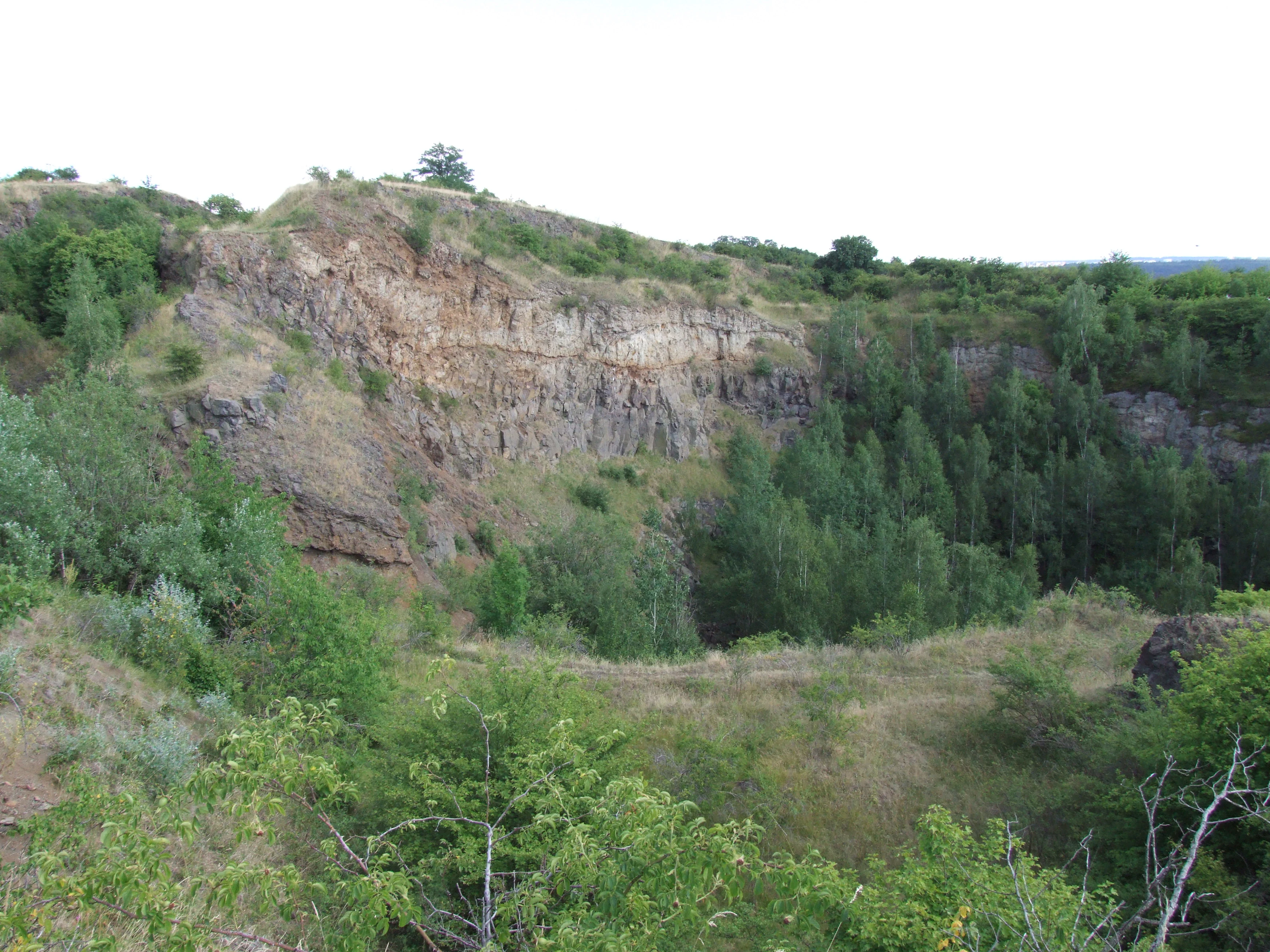
A wide view of an abandoned quarry at Vinařická hora, featuring steep, rocky cliffs and slopes covered in patches of green trees and tall grass.
The quarry face at Vinařická hora, showing exposed volcanic rock layers and surrounding vegetation.

Vinařická hora history and protected-area timeline

Vinařická hora's modern significance begins with the long history of stone quarrying on its slopes. Extraction of the volcanic rock began in the 19th century and continued through the 20th century, only ceasing in the 1980s. While the quarrying gradually dismantled parts of the volcanic cone, it also opened rare three-dimensional windows into the volcano's internal structure, exposing alternating beds of basalt, ash, and solidified lava that today form the geological heart of the site.

Recognition of the hill's natural value followed this industrial phase. On 15 February 1985, the District National Committee in Kladno declared the northern, western, and southern slopes of Vinařická hora a protected přírodní památka, or natural monument. The protected area was established explicitly to safeguard the volcanic summit and the threatened thermophilous plant communities that depend on its dry, sunny conditions. Since designation, the site has been managed as both a geological reserve and an ecological sanctuary, supplemented by an interpretive nature trail that traces the slopes and key exposures.

Vinařická hora landscape and geographic character

Vinařická hora forms a compact, asymmetric hill rising to 413 meters above sea level on the otherwise flat Prague Plateau. To the east, the hill blends almost imperceptibly into the broad, nearly level surface of the Rovina, while its western and northern flanks drop sharply, by roughly 140 meters, into the narrow valley of the Knovízský potok. This pronounced relief contrast gives the hill a striking profile when seen from the west and north, while from the east it appears as a gentle rise.

The hill is a textbook example of a dissected stratovolcano remnant. Successive eruptions during the Tertiary built up alternating layers of basaltic lava, volcanic ash, and pyroclastic material, and these beds are still clearly visible in the abandoned quarries that pock the western slopes. Below the volcanic core lie the Cretaceous sandstones and opukas (siliceous marlstones) into which the original magma intruded, while the deeper geology of the area also includes coal-bearing strata that were transformed by contact with the rising magma. Surrounding the hill, the plateau offers long sightlines broken only by occasional villages and woodland edges, making the summit a natural viewpoint over central Bohemia.
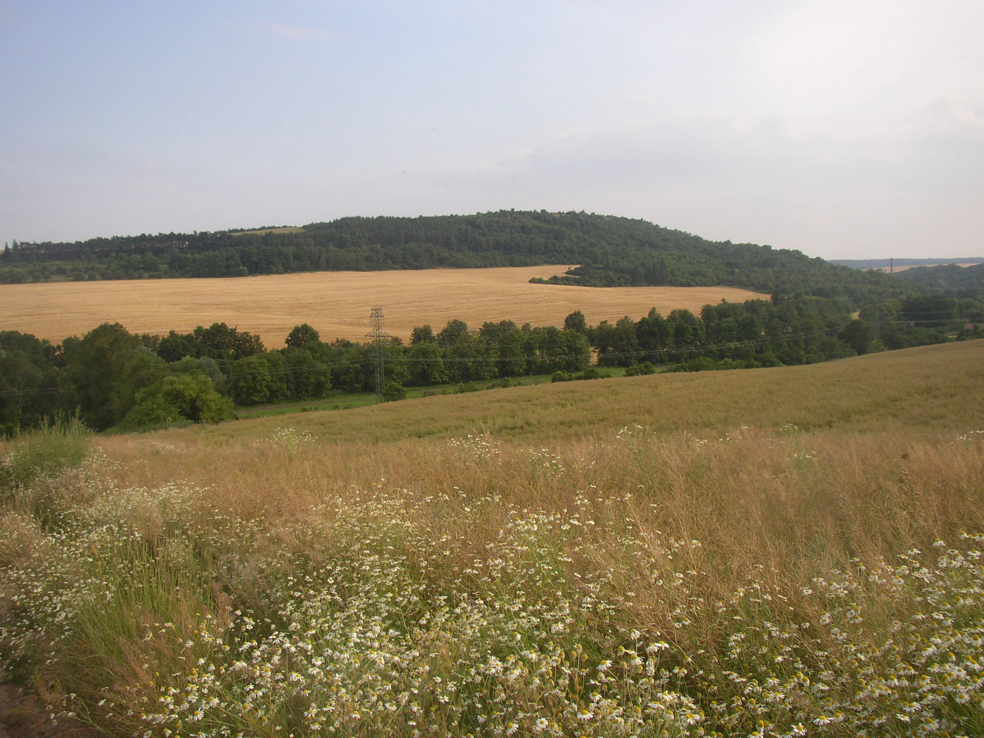
A wide view of a rolling, forested hill rising above golden agricultural fields and a foreground meadow with wildflowers.
A view of the northern slopes of Vinařická hora from a field road in the Knovízský potok valley.

Vinařická hora ecosystems, habitats, and plant life

The natural monument at Vinařická hora protects a compact but unusually varied mosaic of habitats for its size. The protected area was originally designated to secure the dry, warm-loving plant communities that thrive on the sun-exposed volcanic slopes, where thin soils and high summer temperatures replicate conditions otherwise rare in central Bohemia. These thermophilous communities form a patchwork with heathland fragments and more mesic woodland on the cooler, shaded flanks.

The diversity of the vegetation is closely tied to the underlying geology: where volcanic basalt and tuff produce well-drained, mineral-rich soils, open grassland and low shrub communities dominate, while the surrounding Cretaceous sandstones and opukas support different plant assemblages. Common woody species on the protected slopes include field maple and Midland hawthorn, which together form much of the structural backbone of the site, while the rare herbaceous flora includes several warm-loving specialists that have become important targets of conservation attention within the protected area.
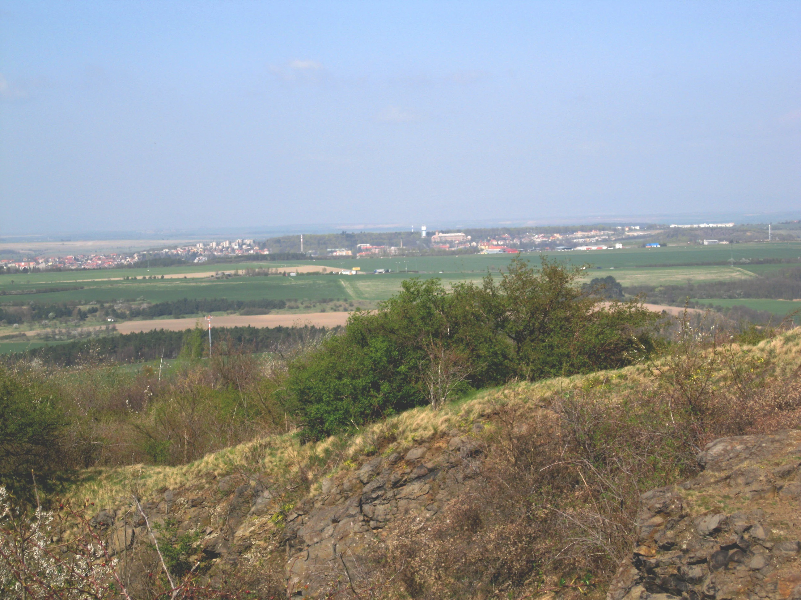
A distant view looking down from a grassy, rocky hillside across a rural landscape towards a distant settlement under a clear sky.
Panoramic view overlooking the landscape from the slopes of Vinařická hora.

Vinařická hora wildlife and species highlights

Source material for Vinařická hora emphasizes plant communities rather than vertebrate fauna, but the mosaic of dry grasslands, heath, and woodland on the slopes provides habitat for the typical central European insect and bird assemblages associated with such a landscape mosaic. The dry, herb-rich open areas support diverse pollinators, while the scattered shrubs and woodland edges offer nesting and foraging habitat for common woodland and edge-of-habitat bird species typical of the Bohemian plateau.

The site's conservation value for wildlife is closely tied to its rare plant communities and the structural diversity of dry-and-warm-loving habitats. By preserving these open, sunny conditions and the associated structural complexity, the protected area indirectly maintains habitat for invertebrates and smaller vertebrates characteristic of similar thermophilous sites elsewhere in central Bohemia.

Vinařická hora conservation status and protection priorities

Vinařická hora has been a protected přírodní památka, or natural monument, since 15 February 1985, when it was designated by the District National Committee in Kladno. The protection covers roughly 69 hectares on the northern, western, and southern slopes of the hill, and the explicit purpose of designation was to safeguard the volcanic summit and its rare thermophilous vegetation, plant communities that are considered threatened in the Czech context.

The site's conservation importance rests on the unusual combination of a Tertiary volcanic landform supporting relict dry-loving plant communities. The diverse bedrock produces varied soils, which in turn maintain a mosaic of vegetation types, including heathland fragments, that would otherwise be poorly represented on the surrounding Prague Plateau. Protection has also preserved the abandoned quarries as key geological exposures, allowing the layered stratovolcano architecture to be studied in continuous section rather than as scattered outcrops. Since designation, the area has been supported by an interpretive nature trail, which serves both public education and long-term monitoring of the protected habitats.

Vinařická hora cultural meaning and human context

The hill's name is closely tied to the adjacent village of Vinařice, from which it takes its identity. The volcanic rock has been quarried here since the 19th century, giving the hill a long working history in the local industrial landscape. The 1985 designation transformed that industrial legacy into a conservation asset, and the establishment of a nature trail integrated the hill into the regional framework of educational and recreational sites in central Bohemia.

Top sights and standout views in Vinařická hora

The standout features of Vinařická hora are its exposed internal structure of an ancient Tertiary stratovolcano, with visible layers of basalt, ash, and lava in successive quarry walls, and its surviving thermophilous plant communities and heathland on sun-exposed volcanic slopes. The hill also combines accessible surface geology with a deeper geological curiosity, the naturally cokeified coal discovered beneath it by the Mayrau mine.

A further highlight is the hill's role as a viewpoint. From the 413-meter summit, the open Bohemian landscape opens out toward the Krušné hory in the northwest, the iconic Říp hill, the peaks of the České středohoří such as Milešovka, Lovoš, and Hazmburk, and on the southeastern horizon landmarks such as Ládví and the Žižkov transmitter in Prague. Together, the geology, ecology, and panoramic setting give this small hill a significance well beyond its modest size.

Best time to visit Vinařická hora

Vinařická hora is an all-season site that changes character through the year. Late spring and early summer are especially rewarding for the protected thermophilous plant communities, when warm-loving grasses and herbaceous species are in active growth and visibility on the dry, open slopes is at its best. Late spring also tends to offer clear, stable atmospheric conditions, favorable for the long-range views from the summit.

In summer, the dry south- and west-facing slopes can become hot and exposed, while autumn brings cooler conditions and softer light for viewing both the vegetation and the stratified volcanic rocks exposed in the old quarries. Winter visits can be worthwhile for visibility across the bare landscape, when the surrounding plateau is often clearer of haze. The site's modest elevation makes it accessible year-round, with seasonal character rather than seasonal access being the main driver of the visit experience.


Monthly climate preview

Long-term temperature and precipitation records across twelve months

Vinařická hora Climate and Monthly Temperature Averages

Vinařická hora exhibits a measured annual temperature and precipitation rhythm recorded from representative coordinate normals between 1991 and 2020. Examining the full monthly breakdown reveals detailed baseline patterns across varying thermal thresholds and daily precipitation rates.
Annual mean9 °C
-2 °C20 °C
Jan-2°
Feb-1°
Mar
Apr
May13°
Jun17°
Jul20°
Aug19°
Sep14°
Oct
Nov
Dec-1°
Warmest month
July

19.7 °C

Coolest month
January

-2.2 °C

Wettest month
June

2.6 mm/day

Driest month
February

1.1 mm/day

Park location guide

Geography guide, regional context, and park location map for Vinařická hora

Vinařická hora park geography, regions, and map view in Czechia

Understand where Vinařická hora sits in Czechia through a broader geographic reading of the surrounding landscape, nearby location context, and its mapped position within the national park landscape.

How Vinařická hora fits into Czechia

Czech Republic is a landlocked Central European country with a population of approximately 10.9 million people. The nation was established as an independent state on January 1, 1993, following the dissolution of Czechoslovakia. Its capital and largest city is Prague, with other major urban centers including Brno, Ostrava, Plzeň, and Liberec.

Wider geography shaping Vinařická hora in Czechia

The Czech Republic is a landlocked country in Central Europe. It is bordered by Germany to the west, Austria to the south, Poland to the northeast, and Slovakia to the southeast. The landscape is predominantly hilly, with the territory covering 78,871 square kilometers.

Map view of Vinařická hora

Use this park location map to pinpoint Vinařická hora in Czechia, understand its exact geographic position, and read its mapped placement within the surrounding landscape more clearly.

Pigeon | © OpenStreetMap contributors

Location context for Vinařická hora

Středočeský kraj

Visual reference guide to basalt quarries, dry grasslands, and protected terrain

Vinařická hora Photos and Volcanic Landscape Scenery

Visual documentation captures the exposed volcanic strata, steep basalt quarries, and varied dry grassland habitats defining Vinařická hora. Detailed field imagery reveals the asymmetric relief and distinct protected landscape character rising above the surrounding plateau.

A wide view of an abandoned quarry at Vinařická hora, featuring steep, rocky cliffs and slopes covered in patches of green trees and tall grass.

A wide shot of a rocky cliff face in an abandoned quarry, with sparse vegetation on the slopes and a blue sky above.

A wide view of a rolling, forested hill rising above golden agricultural fields and a foreground meadow with wildflowers.

A distant view looking down from a grassy, rocky hillside across a rural landscape towards a distant settlement under a clear sky.

Park atlas

Compare surrounding geological monuments and connected regional landscapes

Explore Protected Areas and Parks Near Vinařická Hora in Central Bohemia

Discover protected areas and volcanic reserves situated across the surrounding Central Bohemian territory after reviewing Vinařická hora. Browsing adjacent regional terrain reveals shared geological formations and diverse conservation landscapes throughout the Prague Plateau.
A wide watercolor painting showing a landscape of green hills, scattered trees, and distant pink and purple mountains under a pale sky.
Natural monumentStředočeský kraj
About 3.8 km away#1 closest

West

Smečno Natural Monument: A Protected Woodland Ecosystem in Středočeský Kraj

Geography and conservation mapping in the Czech Republic

Located in the Kladno District, Smečno Natural Monument preserves mature deciduous trees essential for the survival of the hermit beetle. The site acts as a geographical link between distinct landform units, offering a clear look at how small, cavity-rich forest patches maintain ecological connectivity within the broader Central Bohemian landscape.

Area
0.772 km²
Established
2012
IUCN
IV
Relief
Upland
Watercolor painting of a pastoral landscape featuring rolling green hills, patches of trees, and a river flowing through the center.
Natural monumentStředočeský kraj
About 5.2 km away#2 closest

North

Slánská hora Natural Monument: Volcanic Geography and Protected Hilltop Terrain in Central Bohemia

Detailed geological mapping of a Tertiary volcanic outlier and historic monument

Slánská hora functions as a significant geological landmark where basaltic vent remnants meet centuries of human history. This natural monument offers a window into the volcanic processes of the region through exposed columnar basalt and rock fissures. The site serves as a vital protected area, balancing remnants of warm-loving steppe vegetation and deciduous forest with the legacy of former quarries and ancient archaeological strata atop the Slaný ridge.

Area
0.022 km²
Established
1998
IUCN
III
Relief
Mountain
A horizontal watercolor painting showing a winding stream flowing through a lush, green valley with rolling hills and distant mountains under a soft light.
Natural monumentCentral Bohemian Region
About 5.3 km away#3 closest

West

Smečenská rokle Natural Monument: Geological Gorge and Protected Landscape

Geological cross section in the Central Bohemian Region

Smečenská rokle is a compact natural monument featuring a deep erosional canyon cut into the marlstone plateau. The site offers a detailed stratigraphic view of Bohemian Cretaceous Basin sediments while preserving rare patches of scree and ravine forest within the broader agricultural environment of Central Bohemia.

Area
0.062 km²
Established
1987
IUCN
III
Relief
Upland
Watercolor illustration of a peaceful, open landscape with gentle hills in the background and clusters of trees in the foreground.
Nature reserveStředočeský kraj
About 15 km away#4 closest

Northwest

Na Pilavě Nature Reserve: A Detailed Botanical Atlas of the Středočeský kraj Landscape

Mapping protected orchid habitats and forest flora in the Džbán highland.

Na Pilavě is a specialized nature reserve in the Kladno District, valued for its dense concentration of rare woodland orchids and the critically endangered black false hellebore. Set within the forested slopes of the Pilavské údolí, this protected area serves as a vital refuge for thermophilic plant communities and ancient deciduous forest flora.

Area
0.031 km²
Established
1969
IUCN
IV
Relief
Upland
Watercolor painting of a rolling Czech landscape featuring meadow flowers in the foreground, forest in the midground, and distant hazy hills.
Natural monumentStředočeský kraj
About 15 km away#5 closest

South

Markův mlýn Natural Monument: Exploring the Geography and Protected Flora of Central Bohemia

A rare botanical reserve featuring unique rock-steppe plant communities

Markův mlýn is a protected natural monument situated in the Středočeský kraj region, characterized by its rare combination of dry, thin-soil hillside meadows and stream-influenced valley terrain. The area serves as a critical habitat for specialized steppe flora, including the protected Bohemian pasqueflower. This record offers a detailed look at the site's compact geography and the specific environmental conditions that sustain its unusual plant communities.

Area
0.001 km²
Established
1987
IUCN
III
Relief
Lowland
A horizontal watercolor illustration showing a soft-toned landscape with green trees in the foreground, rolling yellow-green fields in the midground, and faint mountains in the background.
Natural monumentStředočeský kraj
About 15 km away#6 closest

Northwest

Smradovna Natural Monument: Geography and Protected Habitats in Central Bohemia

A protected stream valley system within the Stredocesky kraj region.

Smradovna preserves a unique concentration of lowland habitats, including calcareous beech forests and rare alkaline fens. This protected natural monument, located near Bilichov, is defined by its characteristic travertine springs and continuous stream-corridor ecosystem. Gain insight into the regional geography and botanical significance of this tightly knit protected landscape through our structured mapping and data.

Area
1.556 km²
Established
2014
IUCN
IV
Relief
Upland
A soft, painterly watercolor illustration of a wetland scene with gentle green fields, faint distant hills, and low-growing vegetation in the foreground against a white background.
Natural monumentStředočeský kraj
About 16 km away#7 closest

West

Na Novém rybníce Natural Monument: Wetland Geography and Protected Area Atlas

A diverse protected mosaic of meadows and pond basins

Examine the detailed landscape of Na Novém rybníce, an ecologically rich natural monument in the Středočeský kraj. This protected area showcases a compact assemblage of pond, reed marsh, and rare fen meadow vegetation that illustrates the unique character of lowland Bohemian wetlands.

Area
0.054 km²
Established
1990
IUCN
III
Relief
Lowland
Natural monumentStředočeský kraj
About 19 km away#8 closest

Northeast

Veltrusy Natural Monument: Protected Woodland and Historic Park Geography in Středočeský kraj

English-style designed landscapes and floodplain ecological habitats.

Veltrusy Natural Monument is a protected area located on the right bank of the Vltava River, defined by its horseshoe-shaped layout and mosaic of oak-beech woodlands. The site represents a rare intersection of cultural heritage and nature conservation, preserving veteran trees that support significant invertebrate populations. Its geography consists of gently undulating floodplain terrain shaped by the Mlýnský potok, historic avenues, and managed meadows.

Area
2.555 km²
Established
2013
IUCN
III
Relief
Lowland

Common questions about visiting, size, designation, and location context for Vinařická hora

Vinařická hora FAQs for park facts, access, geography, and protected area context

Find quick answers about Vinařická hora, including protected-area facts, park geography, trail and visitor context, and how the park fits into its surrounding country and regional landscape.
MoriAtlas Explorer

Continue Your Protected Areas Search Across the Global Atlas

Deepen your exploration by continuing the structured search for national parks and protected areas worldwide. Utilize the comprehensive filtering capabilities to compare different conservation landscapes and refine your understanding of global park geography. Discover more about the distribution and characteristics of protected natural areas.

Global natural geography