
Mori Atlas logo
Natural monumentVíno

Examining the ecological boundaries and botanical significance of this eastern Bohemian forest.

Víno Natural Monument: An Authorized Protected Landscape Map and Geographic Profile

(Přírodní památka Víno)

Víno Natural Monument represents a protected lowland oak and hornbeam forest situated within the Královéhradecký kraj region of the Czech Republic. This site serves as a crucial ecological refuge, characterized by its continuity as a broadleaf woodland and its role in maintaining stable populations of saproxylic beetle species. The mapped area highlights the importance of old-growth trees, standing deadwood, and decaying timber structures that define the terrain and regional biological diversity of this eastern Bohemian site.

oak-hornbeam forestlowland broadleaf foreststag beetle habitatsaproxylic beetlesdeadwood habitatold-growth trees
A flat vector-style digital illustration showing a valley with a central waterfall flowing into a river, surrounded by pine trees and rocky cliffs.

Víno

Natural monument

Park overview

Structured park overview, official facts, and landscape profile for Víno Natural Monument

Víno Natural Monument park facts, protected area profile, and essential visitor context

Review the core facts for Víno Natural Monument, including designation, size, terrain, visitor scale, habitats, and operating context in one park-focused overview.

About Víno Natural Monument

Víno Natural Monument is a protected lowland broadleaf forest in the eastern Bohemian countryside, in the Hradec Králové District. Although modest in size, the site carries an outsized ecological role: it preserves one of the few remaining isolated oak-hornbeam woodland complexes in an otherwise agricultural part of the region, and it does so with a forest footprint that has remained largely intact for nearly two hundred years.

The protected area was formally declared on 26 November 2013 by the Regional Authority of the Hradovéhradecký Region, and is registered under Czech nature conservation code 5810. Its boundary mirrors that of the forest itself, which sits at the western edge of Převýšov, near Lovčice, at relatively low elevations around 220 to 239 meters above sea level. The forest is largely composed of sessile oak as the dominant tree, with hornbeam forming the understory layer, a structural composition typical of Central European oak-hornbeam forests.

What sets Víno apart from many similarly sized Czech natural monuments is the deliberate orientation of its management toward very old trees and their decay stages. The conservation plan calls for retaining groups of old trees, allowing them to reach advanced stages of decomposition, and preserving torsos, fragments, and cut stumps. This focus on deadwood and aging trees is the technical foundation of the site's value for saproxylic insects and especially the stag beetle.

Quick facts and research context for Víno Natural Monument

Víno Natural Monument is located in the Hradec Králové District of the Hradec Králové Region in eastern Bohemia, near the villages of Lovčice and Převýšov. The protected area covers roughly 72 hectares of isolated forest on gently lowland terrain at elevations between about 220 and 239 meters above sea level.

Established on 26 November 2013 by the Regional Authority of the Hradec Králové Region, the site is classified under IUCN Category III as a natural monument (přírodní památka). Its protection is fundamentally tied to the long-term survival of old-growth broadleaf trees and the insect communities they support, especially the stag beetle.

The current woodland extent is believed to correspond closely to the forest cover present in the area almost two centuries ago, giving the site the character of a long-persisting forest relict in a predominantly agricultural landscape.

Protection and recognition

Documented terrestrial protection scope and official designation records for Víno

Víno Protection Status and Natura 2000 International Recognition

Territorial protection records for Víno outline official conservation scope and administrative standing across official databases. Verified Natura 2000 framework entries establish documented international recognition for the protected landscape.

International recognition

Protection details

Protection scope
Terrestrial
Park context

Deeper park guide and search-rich context for Víno Natural Monument

Víno Natural Monument history, landscape, wildlife, and travel context

Explore Víno Natural Monument through its history, landscape character, ecosystems, wildlife, conservation priorities, cultural context, and seasonal travel timing in a structured park guide built for atlas discovery and search intent.

Why Víno Natural Monument stands out

Víno Natural Monument is best known for being one of the important localities for the stag beetle (Lucanus cervus) in eastern Bohemia. The protection regime is explicitly designed around old trees, decaying trunks, stumps, and dead wood; the sort of microhabitats that large saproxylic beetles depend on for their larval development. Beyond its entomological role, the site is valued as a remnant oak-hornbeam forest that has retained its extent since the early nineteenth century. This continuity of broadleaf woodland in a heavily cultivated region gives the site additional significance as a botanical and ecological refuge.
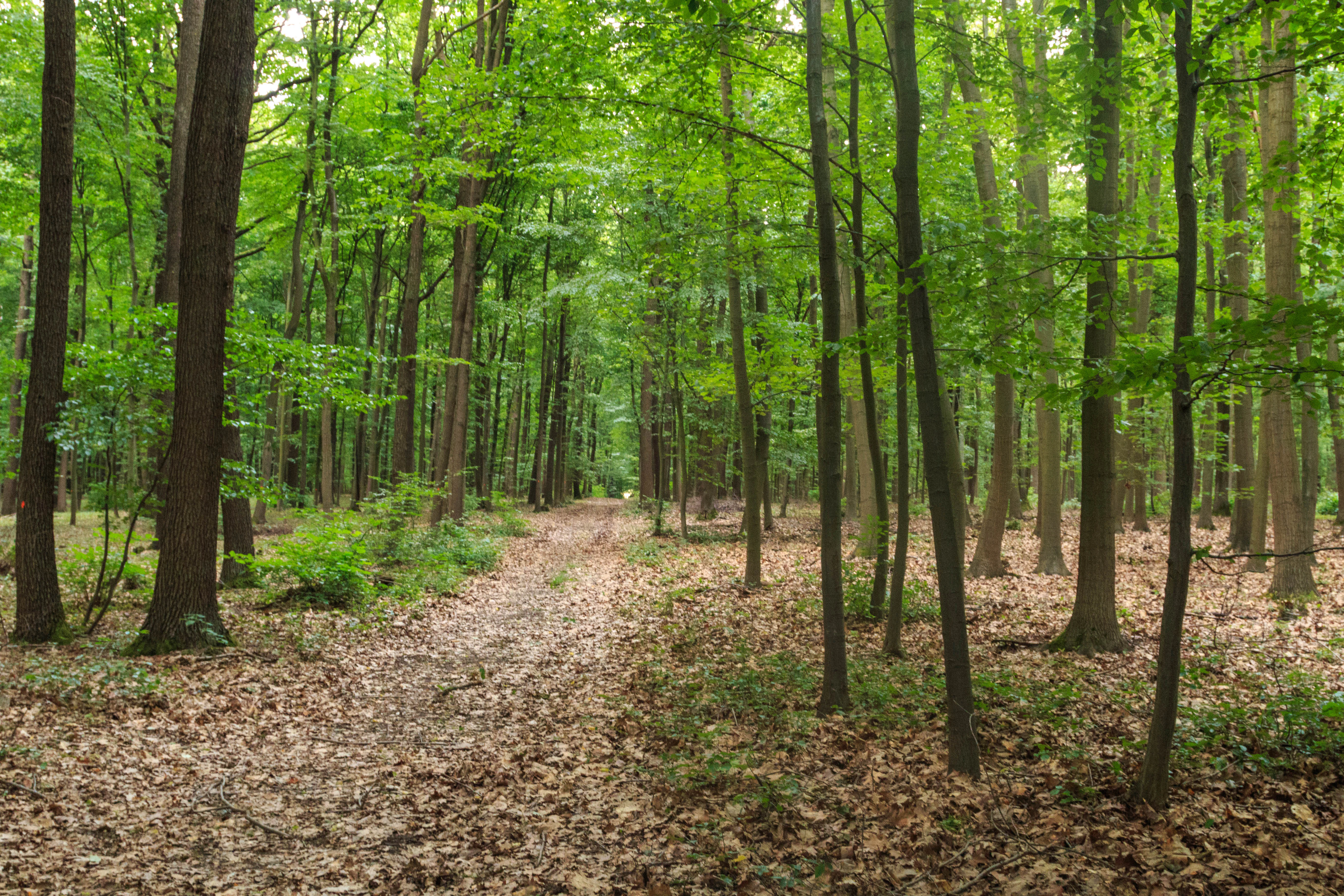
A dirt forest path disappearing into a lush, green deciduous forest filled with tall tree trunks and fallen leaves.
A dirt path leads through the dense canopy of the Víno natural monument.

Víno Natural Monument history and protected-area timeline

The Víno forest has existed as a discernible woodland block for nearly two centuries, with its current extent broadly matching the forest cover shown on historical maps from the early nineteenth century. Through the surrounding region's gradual conversion to farmland, this tract survived as an isolated relict of native broadleaf woodland.

Formal protection came relatively recently. On 26 November 2013, the Regional Authority of the Hradec Králové Region declared the area as Přírodní památka Víno, a natural monument under Czech nature conservation law. The designation was driven primarily by the need to secure stable populations of the stag beetle (Lucanus cervus), a strongly threatened species, by maintaining and managing the old-tree habitats on which it depends.

Since its establishment, management of the site has focused on preserving old trees and deadwood structures rather than on commercial forestry, reflecting both the site's ecological fragility and the particular habitat requirements of the beetle species it was created to protect.

Víno Natural Monument landscape and geographic character

The landscape of Víno Natural Monument is that of a flat to gently rolling lowland, typical of the agricultural countryside of the Hradec Králové District in eastern Bohemia. The protected area sits at elevations from roughly 220 to 239 meters above sea level, rising only modestly above the surrounding farmland. There is no dramatic topography here; the defining character of the place is its forest itself, set against an open, cultivated matrix.

The woodland is a closed-canopy broadleaf forest with a clear visual identity in late summer and autumn, when the dark green of the oaks contrasts with the lighter tones of the hornbeam understory. Stand structure is uneven, with older trees scattered through the canopy and a notable amount of deadwood, including standing torsos and fallen trunks that give parts of the forest a rugged, semi-natural feel despite its small size and accessible location near Převýšov.
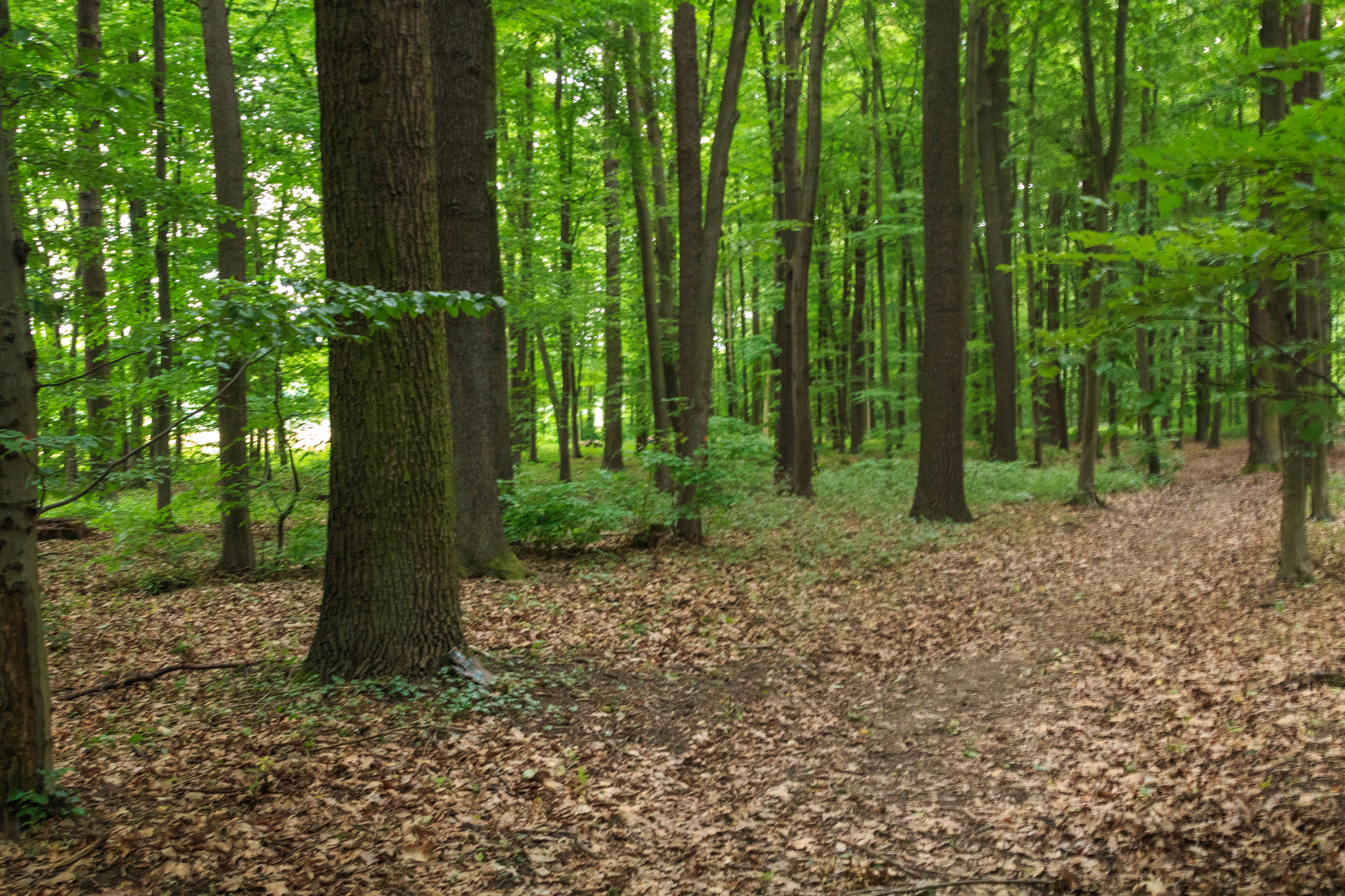
A view of an oak-hornbeam forest in Víno Natural Monument, featuring tall deciduous trees with thick trunks, green foliage, and a forest floor covered in dry brown leaves.
A view into the lush deciduous forest of Víno Natural Monument.

Víno Natural Monument ecosystems, habitats, and plant life

The vegetation of Víno is dominated by oak-hornbeam forest communities, with sessile oak functioning as the principal tree species and hornbeam occupying much of the understory. This combination gives the forest its structural coherence as a central European broadleaf woodland type and reflects the edaphic and climatic conditions of the Bohemian lowlands.

Surveys have recorded approximately 287 species of higher plants within the protected area. Three species are specially protected under Czech law (Act 114/1992 Coll.), and a further nineteen species appear on the IUCN Red List, indicating a botanical richness that is significant for a forest of this size. A small group of additional species, including common columbine (Aquilegia vulgaris) and dotted loosestrife (Lysimachia punctata), are present in the area but are considered naturalized rather than native, and their occurrence is regarded as secondary.
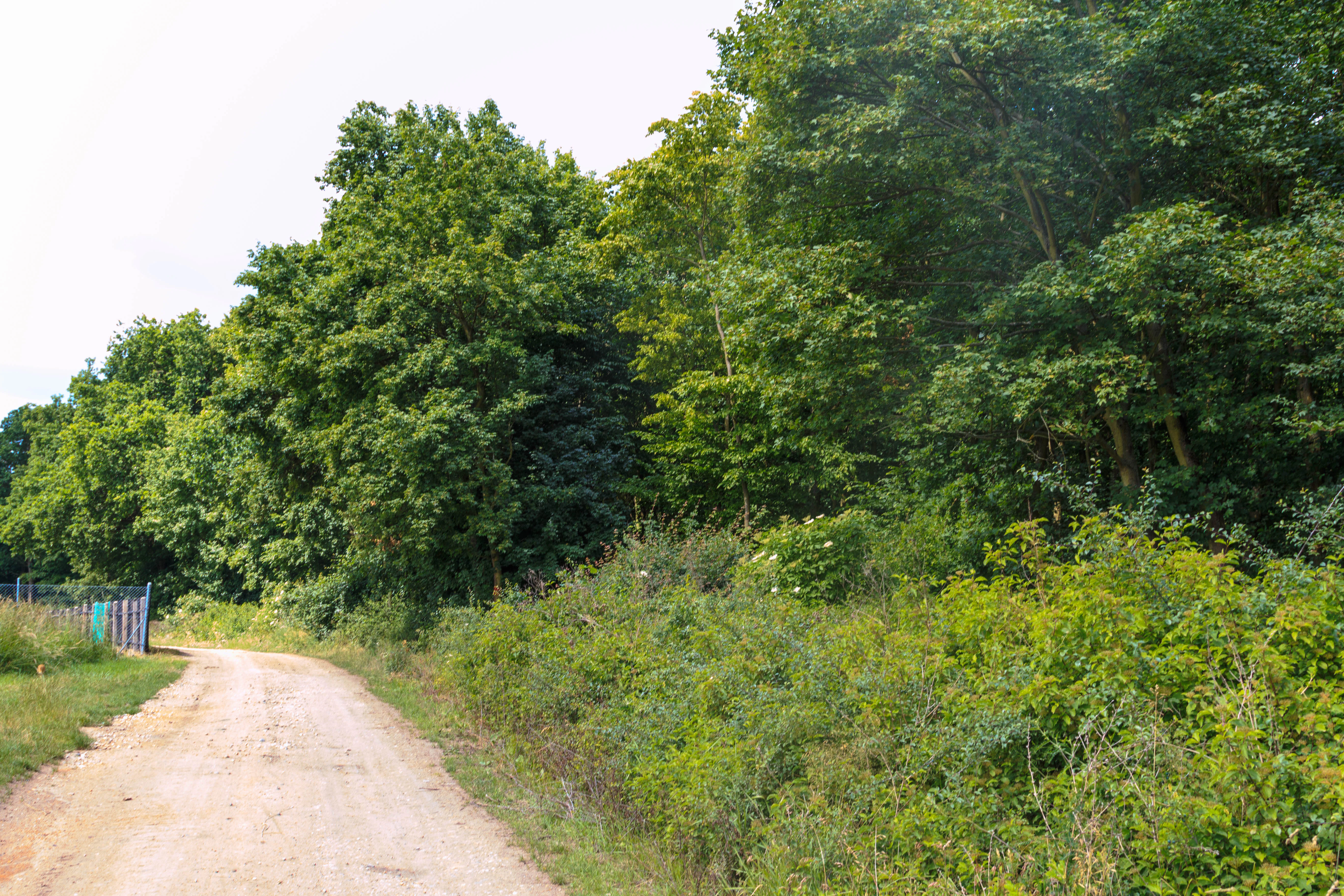
A wide dirt trail curves along the edge of a dense green forest, with a small fence visible on the far left.
A dirt path running along the edge of the woodland at the Víno Natural Monument.

Víno Natural Monument wildlife and species highlights

The wildlife profile of Víno is dominated by invertebrates, especially saproxylic beetles associated with old broadleaf trees and deadwood. The protected area was established specifically to maintain a stable population of the stag beetle (Lucanus cervus), a species classified as strongly threatened in the Czech Republic. From an entomological perspective, Víno is regarded as an important locality for stag beetles in eastern Bohemia.

Field surveys have documented a total of 42 beetle species from 24 families within the site, indicating a notably diverse saproxylic beetle community for a forest of this size. The combination of mature oaks, aging hornbeams, and abundant decaying wood provides a wide variety of microhabitats for these insects, from larval development in dead roots and rotting trunks to adult feeding and mating sites in the canopy.
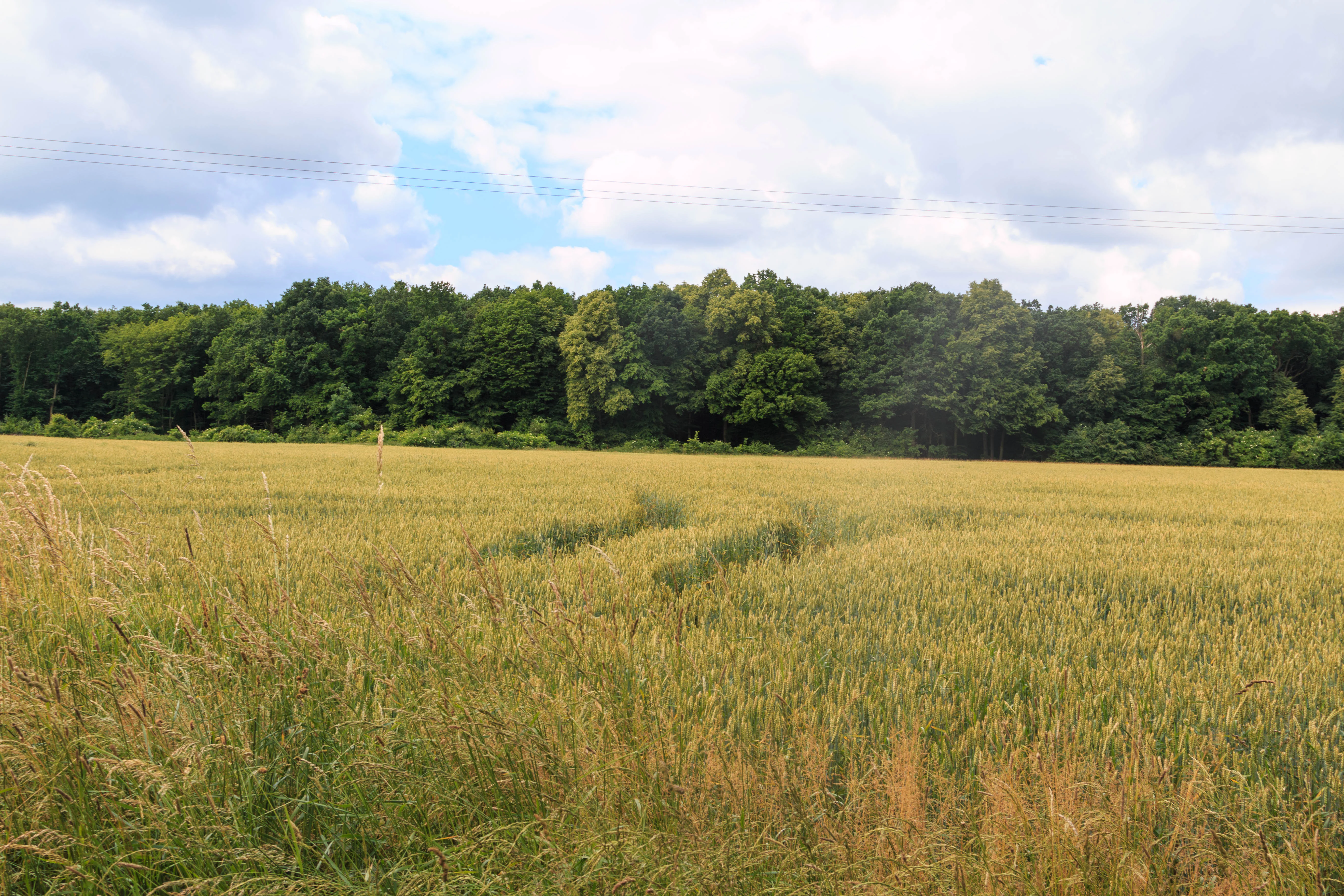
A wide view of a yellow grain field in the foreground leading to a dense line of mature green trees under a cloudy sky.
A view of the forest complex at the Víno natural monument, bordered by agricultural fields.

Víno Natural Monument conservation status and protection priorities

The conservation significance of Víno Natural Monument centers on the long-term preservation of oak-hornbeam forest habitat in an agricultural lowland landscape where such forest fragments are increasingly rare. By protecting an isolated woodland block whose extent has remained stable for roughly two centuries, the site safeguards both a botanical refuge and a structural legacy of older trees that cannot be quickly replaced once lost.

Management of the reserve emphasizes minimal interference with the natural aging of trees. Conservation efforts focus on retaining old trees until they reach advanced stages of decay, keeping torsos, fallen fragments, and cut stumps in place, and avoiding the kind of intensive forestry cycles that would remove deadwood habitats. These measures directly support the site's principal conservation target, the stag beetle, while also benefiting a broader community of saproxylic invertebrates and the many rare plant species recorded there.

Top sights and standout views in Víno Natural Monument

Víno Natural Monument stands out as a small but ecologically rich example of lowland oak-hornbeam forest in eastern Bohemia, with a footprint that has not substantially changed for close to two hundred years.

Its defining features include venerable oaks and hornbeams, abundant deadwood and decaying trunks, and a stag beetle population regarded as one of the important occurrences of the species in the region. For visitors interested in forest ecology, saproxylic beetles, or simply in seeing a surviving patch of broadleaf woodland in an intensively farmed landscape, Víno offers a compact and approachable example of Czech nature conservation at the natural-monument scale.

Best time to visit Víno Natural Monument

Late spring and early summer are well suited to a visit, when the broadleaf canopy is in full leaf, woodland flowers are at their peak, and stag beetles become most active and are easiest to observe around old oaks and decaying wood.

Autumn also has its appeal, with the changing colors of oak and hornbeam making the forest's structural character especially visible. Winter visits offer the best opportunity to see the deadwood features of the forest clearly, when fallen leaves reveal torsos, stumps, and decaying trunks distributed across the stand.

Monthly climate preview

Track monthly precipitation averages and multi year temperature curves for Víno

Víno Climate Normals and Long Term Temperature Patterns

Representative coordinate records show measured multi year temperature ranges and daily precipitation averages across twelve distinct monthly cycles. Examining the complete climate profile reveals detailed shifts in baseline thermal conditions and precipitation distribution throughout the year.
Annual mean8 °C
-3 °C20 °C
Jan-3°
Feb-1°
Mar
Apr
May13°
Jun17°
Jul20°
Aug19°
Sep14°
Oct
Nov
Dec-1°
Warmest month
July

19.6 °C

Coolest month
January

-2.8 °C

Wettest month
July

2.8 mm/day

Driest month
April

1.2 mm/day

Park location guide

Geography guide, regional context, and park location map for Víno Natural Monument

Víno Natural Monument park geography, regions, and map view in Czechia

Understand where Víno Natural Monument sits in Czechia through a broader geographic reading of the surrounding landscape, nearby location context, and its mapped position within the national park landscape.

How Víno Natural Monument fits into Czechia

Czech Republic is a landlocked Central European country with a population of approximately 10.9 million people. The nation was established as an independent state on January 1, 1993, following the dissolution of Czechoslovakia. Its capital and largest city is Prague, with other major urban centers including Brno, Ostrava, Plzeň, and Liberec.

Wider geography shaping Víno Natural Monument in Czechia

The Czech Republic is a landlocked country in Central Europe. It is bordered by Germany to the west, Austria to the south, Poland to the northeast, and Slovakia to the southeast. The landscape is predominantly hilly, with the territory covering 78,871 square kilometers.

Map view of Víno Natural Monument

Use this park location map to pinpoint Víno Natural Monument in Czechia, understand its exact geographic position, and read its mapped placement within the surrounding landscape more clearly.

Pigeon | © OpenStreetMap contributors

Location context for Víno Natural Monument

Královéhradecký kraj
Recorded earthquake history

Examine the Seismic History Associated with Víno Natural Monument

Browse the documented catalogue of earthquake events recorded near the boundaries of Víno Natural Monument. MoriAtlas organizes these historical records by magnitude and proximity to help researchers and visitors understand regional seismic patterns without presenting an assessment of future hazards.

Víno Natural Monument Earthquake Records

Catalogued events

1 event

Strongest magnitude

Magnitude 3.1

Most recent event

Nov 21, 1979

This history includes earthquakes recorded inside the park or within 50 km of its borders

Explore detailed photographs showcasing the oak and hornbeam habitats of Víno

Víno Photos and Protected Landscape Imagery: Visualizing the Forest Sanctuary

Visual records capture the distinctive canopy structure, ancient timber, and deadwood microhabitats that define the lowland forest environment of Víno. Examining these protected area views provides clear visual context on relict woodland conservation and regional botanical diversity.

A dirt forest path disappearing into a lush, green deciduous forest filled with tall tree trunks and fallen leaves.

A thick deciduous forest featuring tall, thin trees with brownish bark, growing out of a leaf-covered forest floor.

A view of an oak-hornbeam forest in Víno Natural Monument, featuring tall deciduous trees with thick trunks, green foliage, and a forest floor covered in dry brown leaves.

A wide dirt trail curves along the edge of a dense green forest, with a small fence visible on the far left.

A wide view of a yellow grain field in the foreground leading to a dense line of mature green trees under a cloudy sky.

Park atlas

Compare surrounding lowland forests and regional protected landscapes

Exploring Parks Near Víno and Other Protected Areas in the Region

Visitors can browse other protected areas near Víno to compare regional lowland forests and ancient woodland reserves. Expanding the search reveals related conservation sites across the surrounding agricultural countryside.
Natural monumentKrálovéhradecký kraj
18 km away#1 closest

North

Veselský háj Natural Monument: Geographic Boundaries and Protected Landscape Context

Lowland forest and wetland mosaic in the Czech Republic

Veselský háj stands as a key natural monument in the Královéhradecký kraj region; characterized by its well-preserved oak-hornbeam woodland and diverse botanical assemblages. The site offers a window into the structure of Bohemian lowland ecosystems, where rare species like the Siberian iris and violet helleborine thrive within a matrix of ancient forest and open water. Explore the boundaries and topographic features of this significant protected terrain.

Area
442.71 km²
Established
1998
IUCN
III
Relief
Lowland
A soft watercolor illustration of a winding stream flowing through green meadows and trees with distant low hills in the background.
Natural monumentPardubice Region
About 22 km away#2 closest

Southeast

Meandry Struhy Natural Monument: A Case Study in Elbe Lowland Stream Geography

Riparian forests and winding stream channels in Pardubice Region.

Meandry Struhy stands as a significant natural monument in the Pardubice Region, protecting the unique geomorphology of a freely meandering stream. The area provides a rare look at undisturbed riparian galleries, floodplain forests, and vital nesting habitats for lowland bird species. This protected landscape offers a clear view into the ecological processes of the Elbe lowlands, where natural watercourse behavior continues to shape the local environment.

Area
0.402 km²
Established
1980
IUCN
IV
Relief
Lowland
A horizontal watercolor painting of a serene wetland scene with birch trees, calm water reflecting the sky, and grassy shores.
Natural monumentStředočeský kraj
29 km away#3 closest

West

Milčice Natural Monument: A Protected Wetland Sanctuary in the Středočeský kraj

Rare calcareous spring systems and lowland fen ecology

Milčice serves as a regionally important natural monument in the Středočeský kraj, protecting a distinct set of tufa-forming springs. This site offers a rare glimpse into the specialized ecology of mineralized lowland wetlands, providing a stark contrast to the surrounding agricultural terrain of the Middle Elbe Table.

Area
0.041 km²
Established
2017
IUCN
III
Relief
Lowland
An illustrative style digital painting of a tranquil park scene with a lake in the foreground, a path along the bank, and mountains in the distance, depicted with a muted, pastel-toned color palette.
Protected landscapeChrudim District
About 30 km away#4 closest

Southeast

Přírodní park Heřmanův Městec: Geographic Profile and Protected Landscape Boundaries

Tracing the elevation transitions of the Chrudim District foothills

This protected landscape in the Chrudim District merges man-made baroque vistas with natural oak woodlands. The park terrain rises over 100 metres from water-side flats to forested ridges, providing a distinct study in regional geology and calcareous soil habitats that support rare beetle and bat populations.

Area
3.41 km²
Established
1996
Relief
Mixed relief
Climate
Temperate
Watercolor painting of a peaceful wetland landscape with a winding stream, soft rolling hills in the background, and wild meadow vegetation in the foreground.
Natural monumentKrálovéhradecký kraj
About 31 km away#5 closest

East

Roudnička a Datlík Natural Monument: Wetland Geography and Protected Landscape Context

A vital ecological refuge within the Královéhradecký landscape.

Roudnička a Datlík protects a rare wetland mosaic of fishponds, reedbeds, and purple moor-grass meadows on the edge of the East Bohemian table. This natural monument remains a key site for regional conservation management, supporting a variety of orchids and waterbirds within an urban-fringe environment. Explore the site's mapped boundaries and its role in protecting lowland biodiversity.

Area
0.297 km²
Established
1988
IUCN
IV
Relief
Lowland
A horizontal watercolor illustration depicting a soft, rolling landscape with clusters of green trees against a pale, light-colored background.
Nature reserveCzechia
About 32 km away#6 closest

East

Na Plachtě Nature Reserve: Mapped Wetlands and Conservation Geography in Czechia

Urban-edge wetland mosaic with ponds and peat meadows

Located in eastern Bohemia, the Na Plachtě nature reserve encompasses a 39-hectare landscape of ponds, marshland, and sandy patches. This important Natura 2000 protected area offers a deep look into specialized amphibian and insect habitats, maintained through active management and community-led conservation efforts.

Area
0.388 km²
Established
2013
Scope
Terrestrial
Water
Major water bodies
Watercolor painting of a landscape featuring soft green hills, coniferous trees, and low-lying wetland vegetation in shades of pink and green.
Nature reserveKrálovéhradecký kraj
About 32 km away#7 closest

East

Na Plachtě 3 Nature Reserve: Mapped Protected Landscapes in the Královéhradecký kraj

Explore the diverse sandy habitats and protected terrain of this Czech natural monument

Na Plachtě 3 represents a critical protected enclave in the Královéhradecký kraj, characterized by its mosaic of dry heaths, open sand patches, and peat meadows. This lowland site provides essential hibernation grounds for amphibians and invertebrates, maintaining a rich biological profile that contrasts with the urban-adjacent geography of Hradec Králové. Analyze its protected boundaries, geological history, and early successional landscape character through detailed mapping.

Area
0.17 km²
Established
2012
IUCN
IV
Relief
Lowland
A minimalist watercolor painting showing a horizontal landscape with a pond in the foreground, green fields in the midground, and soft rolling hills in the background.
Natural monumentKrálovéhradecký
About 33 km away#8 closest

North

Rybník Jíkavec Natural Monument: Mapping Protected Wetland Habitats in Královéhradecký

A preserved pond and meadow landscape in central Czechia

Rybník Jíkavec protects a compact cluster of wetland habitats, including open water and sedge-rich meadows within the Královéhradecký region. This nature monument highlights the ecological importance of traditionally managed fishponds and their role in maintaining rare inland marsh flora across the local Bohemian countryside.

Area
0.073 km²
Established
1998
IUCN
IV
Relief
Lowland

Common questions about visiting, size, designation, and location context for Víno Natural Monument

Víno Natural Monument FAQs for park facts, access, geography, and protected area context

Find quick answers about Víno Natural Monument, including protected-area facts, park geography, trail and visitor context, and how the park fits into its surrounding country and regional landscape.
MoriAtlas Explorer

Continue Your Protected Areas Search Across the Global Atlas

Deepen your exploration by continuing the structured search for national parks and protected areas worldwide. Utilize the comprehensive filtering capabilities to compare different conservation landscapes and refine your understanding of global park geography. Discover more about the distribution and characteristics of protected natural areas.

Global natural geography