Mori Atlas logo
Natural monumentVrškámen

Understanding the geomorphological history and landscape boundaries of this rare Bohemian boulder.

Vrškámen Natural Monument: A Geological Map of Granite Formations in Středočeský kraj

(Přírodní památka Vrškámen)

Vrškámen serves as a distinctive geological landmark within the rolling hills of the Vlašimská pahorkatina. This protected natural monument preserves a massive porphyritic syenite boulder that emerged through selective Tertiary weathering of the Central Bohemian Pluton. As one of the smallest protected areas in the Czech Republic, it offers a concentrated view into the regional geomorphology and the geological heritage of the Sedlčansko countryside.

geological monumentgranite bouldersyeniteCentral Bohemian Plutonsmall protected areaVlašimská pahorkatina

Vrškámen

Natural monument

Park overview

Structured park overview, official facts, and landscape profile for Vrškámen

Vrškámen park facts, protected area profile, and essential visitor context

Review the core facts for Vrškámen, including designation, size, terrain, visitor scale, habitats, and operating context in one park-focused overview.

About Vrškámen

Vrškámen is a geological natural monument in the Central Bohemian Region of the Czech Republic, near the small village of Petrovice in the Příbram district. It protects a single prominent boulder that rises slightly above the rolling farmland of the Vlašimská pahorkatina, a gently undulating highland in the heart of Bohemia. Despite its diminutive size on paper, the site carries real value for anyone interested in the long-term weathering history of the Bohemian Massif.

The protected object is a roughly rectangular granite boulder about 3.5 meters wide, 5.5 meters long, and 3.2 meters tall, and it is widely regarded as the largest granite boulder in central Bohemia. The boulder is composed of a porphyritic syenite to syenodiorite attributed to the Čertovo břemeno rock type, an intrusive variant associated with the Central Bohemian Pluton. Geologists interpret Vrškámen as the residual core of a larger body of bedrock that was shaped by selective weathering in the Tertiary period, leaving the resistant igneous rock standing while softer surrounding material was worn away.

Although it sits close to the edge of the village of Petrovice, along the road toward Kojetín, Vrškámen was among the very smallest protected areas in the Czech Republic when established in 1977, a fact that continues to make it a curiosity within the national system of small-scale geological protections. The protected site is administered by the Central Bohemian Regional Authority, while documentation and monitoring are carried out through AOPK ČR, the Czech Agency for Nature Conservation and Landscape Protection.

Quick facts and research context for Vrškámen

Vrškámen is a protected natural monument (přírodní památka), a category III designation under the International Union for Conservation of Nature system, located in the Středočeský kraj of central Czechia. It lies in cadastral territory of Vilasova Lhota, roughly half a kilometer southeast of Petrovice in the Příbram district, at an elevation of approximately 450 to 458 meters above sea level.

The site was officially declared on 8 February 1977 and is managed by the Central Bohemian Regional Authority, with documentation maintained by AOPK ČR. The protected object is a sizeable granite boulder measuring roughly 350 by 550 centimeters across and standing about 320 centimeters tall, making it the largest granite boulder in central Bohemia according to local sources.

Protection and recognition

Analysis of documented management scope and official recognition records

Vrškámen Protection Status and Designated Terrestrial Conservation Framework

Terrestrial protection status and administrative conservation records outline the designated framework established for Vrškámen. Structured documentation details the operational scope and verified recognition sources associated with the protected terrain.

Protection details

Protection scope
Terrestrial
Transboundary protection
No
Park context

Deeper park guide and search-rich context for Vrškámen

Vrškámen history, landscape, wildlife, and travel context

Explore Vrškámen through its history, landscape character, ecosystems, wildlife, conservation priorities, cultural context, and seasonal travel timing in a structured park guide built for atlas discovery and search intent.

Why Vrškámen stands out

Vrškámen is best known as the largest granite boulder in central Bohemia and as one of the smallest protected natural areas in the entire Czech Republic. Its scientific and cultural value comes from its geological origin: it is a residual rock form created by the selective weathering of a Cretaceous or Tertiary age pluton, leaving behind a durable boulder of porphyritic syenite to syenodiorite that survived long after the softer surrounding bedrock eroded away. The boulder shares its petrological character with the better-known Husova kazatelna rocking stone nearby, which makes Vrškámen an important reference point for understanding the regional geology of the Sedlčansko area and the broader Vlašimská pahorkatina hill country.
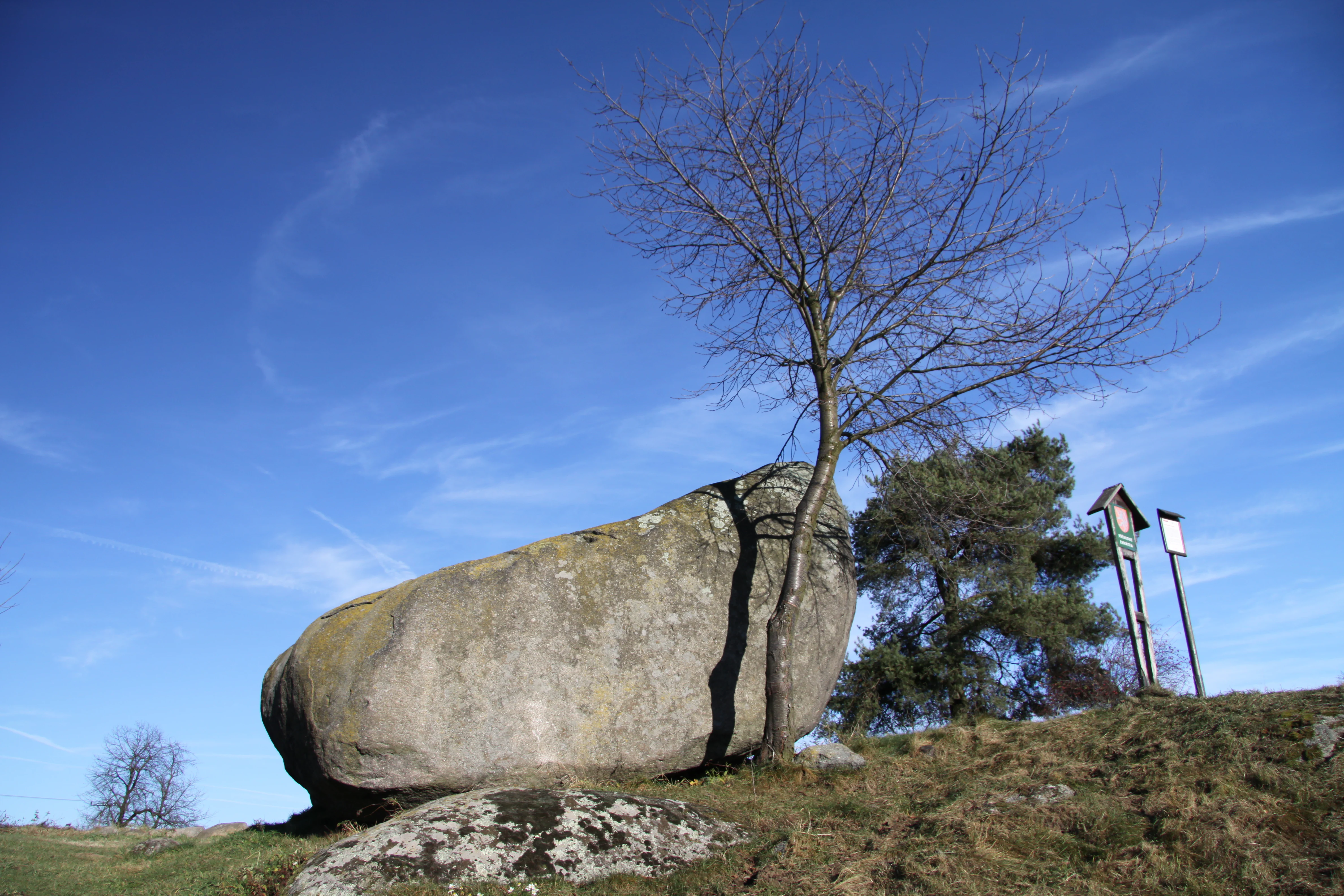
A large, weathered granite boulder sits on a grassy hill next to a small, leafless deciduous tree, with educational signage poles visible in the background against a clear blue sky.
The granite boulder of the Vrškámen natural monument in the Central Bohemian Region.

Vrškámen history and protected-area timeline

Vrškámen was formally declared a protected natural monument (přírodní památka) on 8 February 1977, giving it a long-standing place in the Czech system of small-scale geological protections. The decision to protect the site was driven by the geological and geomorphological value of the boulder itself rather than by any broader ecological landscape.

Over the following decades, the boundary of the protected area became a subject of administrative attention, as different official documents recorded different surface areas, ranging from about 232 square meters to roughly 1276 square meters depending on the version of the survey used. A subsequent geodetically defined boundary, based on four coordinate points, aligned the protected parcel to roughly 232 square meters, an area so small that it places Vrškámen among the very smallest protected natural monuments in the Czech Republic.

Vrškámen landscape and geographic character

Vrškámen sits in the Vlašimská pahorkatina, a region of rolling hills and modest elevations that typifies much of the central Bohemian countryside. The surrounding terrain is gentle rather than dramatic, shaped by long-term weathering of the Central Bohemian Pluton, an extensive body of intrusive igneous rock that underlies much of the area between Prague and the Šumava foothills.

Within this smoothly undulating landscape, Vrškámen itself stands out as an abrupt geological interruption: a compact block of resistant porphyritic syenite, a few meters across, survived while the surrounding rock was gradually stripped away by weathering processes that began in the Tertiary period. The result is a solitary boulder that reads visually as a small rocky island in otherwise arable and settled country, a feature that echoes the wider pattern of residual rock forms found across the Sedlčansko region.

Vrškámen ecosystems, habitats, and plant life

Vrškámen is fundamentally a geological rather than ecological monument, and its nature value lies in the rock itself rather than in any extensive biological community. The protected surface is extremely compact, and the site does not host a notable forest, wetland, or alpine community in the way a large national park would. Instead, its ecological character is that of a small rocky outcrop embedded in an agricultural and rural landscape of fields, meadows, road verges, and the margins of a village.

For visitors and researchers, the site's ecological interest is therefore less about species richness and more about how a tiny patch of exposed igneous rock fits into the broader mosaic of human-used land that surrounds it.

Vrškámen conservation status and protection priorities

The conservation significance of Vrškámen is anchored in its geological rather than biological character. Its protection, formalized in 1977, was intended to preserve an unusually large and well-exposed example of a regionally characteristic residual granite boulder, complete with a documented link to the wider plutonic geology of central Bohemia.

Because the protected boundary is exceptionally small, the site's value is effectively tied to a single physical object: the boulder itself. The long-running boundary discussions documented by AOPK ČR reflect how difficult it can be to translate the protection of a singular geological feature into a stable, legally clear parcel on the ground, a challenge that has made Vrškámen a useful case study within the Czech system of small-scale natural monuments.

Vrškámen cultural meaning and human context

Vrškámen sits in a landscape long shaped by rural Bohemian life, on the outskirts of Petrovice near the road toward Kojetín. The boulder thus exists within a setting of villages, small fields, and quiet country roads, rather than in a remote wilderness. In this region, notable local geological features have traditionally drawn curiosity from residents, naturalists, and travelers alike, a tradition that fits with Vrškámen's longer-standing presence in regional natural heritage literature.

The site's similarity to the better-known Husova kazatelna rocking stone nearby also gives it a modest cultural role as a companion landmark within the local folklore of unusual rocks of the Sedlčansko area.

Top sights and standout views in Vrškámen

Vrškámen is a compact geological treasure: a roughly 3.5 by 5.5 meter granite boulder that has been legally protected since 1977 and is documented as the largest granite boulder in central Bohemia. Its protected footprint is one of the smallest of any natural monument in the Czech Republic, making it a striking example of how a tiny piece of ground can carry real scientific value.

The boulder is composed of porphyritic syenite of the Čertovo břemeno type, the same rock family that forms the more famous Husova kazatelna nearby, and it survives as a residual form shaped by selective weathering of the Central Bohemian Pluton in the Tertiary period.

Best time to visit Vrškámen

Because Vrškámen is a small geological landmark rather than a landscape-scale destination, it can be visited at any time of year. The surrounding Vlašimská pahorkatina has a temperate central European climate, with leafy green countryside in late spring and summer, warm golden tones in early autumn, and occasional snow cover in winter that can make the contrast between the dark boulder and the pale ground especially visible.

Visitors interested in clearer views of the rock surface and surrounding context may favor spring or autumn, when the vegetation around the boulder has not fully expanded and lower sunlight brings out the texture of the igneous rock.

Monthly climate preview

Long-term representative coordinate measurements for Středočeský kraj terrain

Vrškámen Climate Normals: Measured Annual Temperature and Precipitation Rhythm

Representative coordinates record measured monthly temperature and precipitation normals for Vrškámen across a thirty-year climatology period from 1991 to 2020. Examining the complete twelve-month sequence reveals detailed fluctuations in average minimum and maximum thresholds for the protected area.
Annual mean8 °C
-3 °C19 °C
Jan-3°
Feb-1°
Mar
Apr
May13°
Jun17°
Jul19°
Aug19°
Sep14°
Oct
Nov
Dec-2°
Warmest month
July

18.9 °C

Coolest month
January

-2.7 °C

Wettest month
June

2.8 mm/day

Driest month
February

1.2 mm/day

Park location guide

Geography guide, regional context, and park location map for Vrškámen

Vrškámen park geography, regions, and map view in Czechia

Understand where Vrškámen sits in Czechia through a broader geographic reading of the surrounding landscape, nearby location context, and its mapped position within the national park landscape.

How Vrškámen fits into Czechia

Czech Republic is a landlocked Central European country with a population of approximately 10.9 million people. The nation was established as an independent state on January 1, 1993, following the dissolution of Czechoslovakia. Its capital and largest city is Prague, with other major urban centers including Brno, Ostrava, Plzeň, and Liberec.

Wider geography shaping Vrškámen in Czechia

The Czech Republic is a landlocked country in Central Europe. It is bordered by Germany to the west, Austria to the south, Poland to the northeast, and Slovakia to the southeast. The landscape is predominantly hilly, with the territory covering 78,871 square kilometers.

Map view of Vrškámen

Use this park location map to pinpoint Vrškámen in Czechia, understand its exact geographic position, and read its mapped placement within the surrounding landscape more clearly.

Pigeon | © OpenStreetMap contributors

Location context for Vrškámen

Středočeský kraj

Visual exploration of the protected geological monument and surrounding rolling terrain

Vrškámen Photos, Granite Boulder Scenery, and Central Bohemian Landscape Views

Visual documentation captures the solitary granite boulder and rolling agricultural scenery that define the protected landscape around Vrškámen. Examining these field photographs reveals the distinct geomorphological character of the Central Bohemian Pluton and its enduring weathering remnants.

A large, weathered granite boulder sits on a grassy hill next to a small, leafless deciduous tree, with educational signage poles visible in the background against a clear blue sky.

Park atlas

Compare regional geology and connected protected landscapes across central Bohemia

Exploring Parks Near Vrškámen and Surrounding Protected Natural Areas

Visitors exploring Vrškámen can browse other protected natural areas and geological monuments located throughout the surrounding region. Comparing adjacent park geography provides broader context on regional plutonic formations and rolling hill terrain.
Natural monumentStředočeský kraj
About 8.8 km away#1 closest

Northeast

Vápenické jezero Natural Monument: Wetland Geography and Protected Landscape in Středočeský kraj

Mapping the ecological features of the Sedlčany Basin.

Located in the Sedlčany Basin, Vápenické jezero is a protected pond system serving as a vital sanctuary for the fire-bellied toad and diverse wetland bird species. This entry provides a detailed look at its spring-fed water body, bulrush-covered surface, and long-standing ecological role in the broader landscape of central Bohemia.

Area
0.084 km²
Established
2013
IUCN
III
Relief
Upland
A horizontal watercolor painting depicting a soft green landscape with scattered trees, rolling hills, and a pale pink sky on a white background.
Natural monumentJihočeský kraj
About 13 km away#2 closest

Southwest

Sobědražský Prales Natural Monument: Protected Woodland Map and Geographic Context

An ancient oak and beech forest remnant in the South Bohemian Region.

Sobědražský prales represents a significant natural monument within the Czech Republic, protecting a rare stand of aged oaks and beeches. This site offers valuable insights into the historical composition of local forests, supporting critical biodiversity such as hole-nesting birds amidst the managed landscapes of the Jihočeský kraj.

Area
0.017 km²
Established
1986
IUCN
IV
Relief
Upland
A minimalist watercolor illustration depicting a soft, light-toned landscape with a row of trees on the right and distant, blurred hills in the background.
Natural monumentJihočeský kraj
About 16 km away#3 closest

South

Rukávečská obora: Natural Monument and Protected Beech Forest in Jihočeský kraj

A historic protected landscape in the Písek Highlands

Located in the Czech Republic, Rukávečská obora represents a significant natural monument defined by its 225-year-old beech stands. This site provides an essential look at the geological and botanical history of the Písek Highlands, serving as a key protected area for local invertebrate and bird species within the Vltava river valley watershed.

Area
0.067 km²
Established
1929
IUCN
V
Relief
Upland
A watercolor painting of a river landscape with rolling hills in the background and soft vegetation along the banks.
Natural monumentJihočeský kraj
About 16 km away#4 closest

Southeast

Smutný Natural Monument: Geographic Profile and Protected Fluvial Landscape in Jihočeský Kraj

A naturally meandering lowland stream corridor in the Czech Republic

The Smutný Natural Monument protects a significant 2.5 kilometer reach of the Smutná River, characterized by its remarkably intact fluvial morphology. Unlike typical agricultural watercourses in the region, this corridor features natural riffle-pool sequences and sediment deposition patterns along a gentle Bohemian valley. The protected site serves as a vital ecological anchor for riparian vegetation and wetland flora, demonstrating how undisturbed stream dynamics shape local terrain and provide persistent freshwater habitats.

Area
0.044 km²
Established
1985
IUCN
III
Relief
Lowland
Natural monumentJihočeský kraj
About 22 km away#5 closest

Southwest

V Obouch Natural Monument: Geographic Profile of the Lomnice River Valley

Protected riparian corridors and riverine terrain in Jihočeský kraj

Explore the unique geomorphology of V Obouch, a protected river segment in the Czech Republic. This site provides a detailed cross-section of alder floodplain forests, boulder rapids, and canyon-like terrain that defines the ecological character of the South Bohemian river network.

Area
0.051 km²
Established
1986
IUCN
IV
Relief
Upland
A pale, soft watercolor painting of a rolling, grassy meadow landscape with a prominent green mushroom in the foreground and sparse, leafless trees.
Natural monumentJihočeský kraj
About 26 km away#6 closest

Southwest

Malý Kosatín: Protected Botanical Landscapes in the South Bohemian Region of Czechia

A rare fen-meadow sanctuary in the Písek District

Located in the heart of the Czech countryside, Malý Kosatín is a natural monument distinguished by its intense botanical density and traditional meadow management. The site serves as a crucial habitat for threatened orchids and sedge communities, providing a focused view of the ecological character that defines the upland terrain surrounding the Písek District.

Area
0.01 km²
Established
1986
IUCN
IV
Relief
Upland
A horizontal watercolor illustration of a gentle, rolling landscape with green fields, patches of forest, and faint pink floral accents in the foreground.
Protected landscapeBenešov District
About 27 km away#7 closest

Northeast

Přírodní park Džbány-Žebrák: Geography and Protected Area Landscape Map

Mapping the forests and meadows of the Benešov District

Přírodní park Džbány-Žebrák offers a distinct look into the central Bohemian uplands, marked by gentle ridges and spring-fed valleys. This protected area supports an interconnected web of small ponds, damp woodland clearings, and rural agricultural mosaics. Use this resource to trace the park boundaries and understand the regional significance of its protected waters, orchid-rich meadows, and varied, bird-populated forests.

Area
53 km²
Established
1996
Water
Major water bodies
Natural monumentJihočeský kraj
About 34 km away#8 closest

East

Vlašimská Blanice Natural Monument: Mapped River Geography and Protected Valley Terrain

A vital riverine habitat in the South Bohemian Region

Vlašimská Blanice forms a protected natural monument around an unregulated, meandering section of the Blanice River. This landscape is defined by its continuous riparian woodland, gravel-rich riverbed structures, and a surrounding mosaic of floodplains and meadows, providing essential habitat continuity within the Jihočeský kraj terrain.

Area
0.304 km²
Established
2014
IUCN
III
Relief
Upland

Common questions about visiting, size, designation, and location context for Vrškámen

Vrškámen FAQs for park facts, access, geography, and protected area context

Find quick answers about Vrškámen, including protected-area facts, park geography, trail and visitor context, and how the park fits into its surrounding country and regional landscape.
MoriAtlas Explorer

Continue Your Protected Areas Search Across the Global Atlas

Deepen your exploration by continuing the structured search for national parks and protected areas worldwide. Utilize the comprehensive filtering capabilities to compare different conservation landscapes and refine your understanding of global park geography. Discover more about the distribution and characteristics of protected natural areas.

Global natural geography