
Why Wadebruch Nature Reserve stands out
Wadebruch is best known as a compact, ecologically rich example of a lower Leine floodplain landscape. Its most distinctive features are the abandoned, gradually silting-up oxbow arm of the Leine with surrounding alder swamp forest, the dry oak-mixed forest covering the steep former cut-bank terraces, and the fragments of species-poor sandy dry grassland still clinging to the upper terrace edge. Together these elements create a striking small-scale contrast between permanently wet woodland, seasonally flooded grassland, open water remnants, and dry sandy slopes within a few hundred meters.
Wadebruch Nature Reserve history and protected-area timeline
Wadebruch was officially designated as a nature reserve on 27 June 1985, placing its approximately 16 hectares under formal protection under Lower Saxon nature conservation law. Its protection was grounded in its position within the floodplain of the lower Leine and its inclusion in the broader network of sites established to safeguard representative examples of Lower Saxony's riverine landscapes.
The reserve's ecological value is further recognized through its complete overlap with the European Habitats Directive (FFH) site covering the lower stretches of the Aller, Leine, and Oker rivers, embedding Wadebruch within a trans-regional framework for protecting lowland river habitats. The responsible lower nature-protection authority is the Region Hannover, while technical supervision is provided by the Lower Saxony State Office for Water Management, Coastal Defense, and Nature Conservation (NLWKN). Since its establishment, the area has continued to function as a small reference site for the ongoing natural dynamics of an aging Leine oxbow and its associated terraces.
Wadebruch Nature Reserve landscape and geographic character
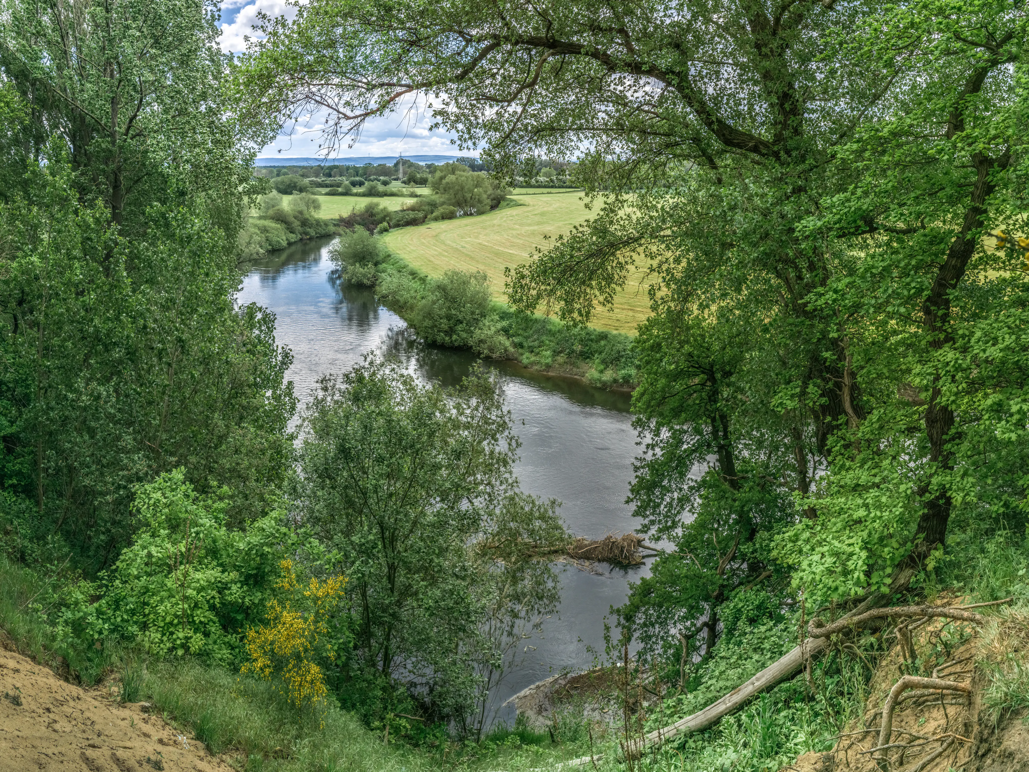
The landscape of Wadebruch is shaped by the contrast between a flat river floodplain and a sharply rising terrace edge. The lower portion of the reserve occupies the Niederung, or lowland, of the Leine near Schloss Ricklingen, where the valley floor lies roughly between 40.9 and 45.4 meters above sea level. Here, the terrain is level and defined by the slow infilling of a former channel of the Leine, which once cut actively against this stretch of bank.
The most prominent landform is the Prallhang, the steep outer bank of the old river meander, now expressed as sandy terrace slopes that rise abruptly above the wet floodplain. These slopes give the small reserve a remarkable topographic relief for its size, and they define the boundary between the permanently or seasonally wet valley floor and the drier upland. The former channel itself, the Altarm, runs as a curved depression through the lower part of the area, holding open water in some sections while other parts have filled in and converted to woodland and reed.
Above the terrace slopes, the sandy upland acts as a natural backdrop to the wet valley, and it is along the upper rim that the narrow band of sandy dry grassland persists. This compressed vertical sequence of water, marsh, grassland, steep slope, dry forest, and open sandy grassland in a single short transect is what gives Wadebruch its distinctive visual and ecological character.
Wadebruch Nature Reserve ecosystems, habitats, and plant life
The ecological identity of Wadebruch is tied closely to the transition between wet and dry habitats across a very short distance. The abandoned Leine channel and its immediate margins support alder spring woodland and alder-ash swamp forest, known in German as Erlen-Quellwald and Erlen- or Erlen-Eschen-Bruchwald. These wet forests are characterized by a pronounced herbaceous understory adapted to periodic waterlogging and to the gradual accumulation of organic matter in the filling channel.
In the sections of the former arm that are still partially open, extensive reed beds (Schilfröhrichte) have developed, while several small areas of flood meadow vegetation, or Flutrasen, occupy the interface between open water and the seasonally flooded grassland beyond. The remaining grassland, much of which may be submerged during high water events of the Leine, forms the largest habitat block of the reserve and reflects the hydrological regime of a lowland river that is still capable of overflowing its banks.
The dry terrace slopes above carry a near-natural oak-rich mixed woodland, contrasting strongly with the damp valley floor in both species composition and microclimate. Along the southwestern upper edge of the slopes, a narrow strip of species-poor sandy dry grassland (Sandmagerrasen) remains as a relic of formerly open, nutrient-poor land on the sandy terrace soils.
Wadebruch Nature Reserve wildlife and species highlights
The wildlife value of Wadebruch arises less from the presence of any single charismatic species than from the close juxtaposition of floodplain wetlands, swamp woodland, reed beds, and dry oak forest within a small area, providing habitat for a wide range of typical lowland river species. The alder swamp forests and reed-fringed remnants of the old channel offer habitat for amphibians, aquatic invertebrates, and wetland birds associated with the lower Leine system.
The seasonally flooded grasslands and the transition to wet woodland support breeding and foraging habitat for bird communities typical of floodplain landscapes in the Hannover Region. The dry oak-mixed forest on the terraces provides habitat for woodland bird species typical of sandy-soil oak forests in the North German plain, while the narrow band of sandy dry grassland on the upper edge can host characteristic insect and plant communities of open sandy habitats.
Wadebruch Nature Reserve conservation status and protection priorities
Wadebruch is significant from a conservation perspective because it preserves, in compact form, the structure of a lowland river landscape that has otherwise been heavily altered straightening, embankment, and agricultural conversion. The reserve's full inclusion in the larger Natura 2000 (FFH) site for the lower Aller, Leine, and Oker rivers connects it directly to the European network for protecting habitat types listed under the EU Habitats Directive.
Its IUCN Category IV status reflects its role as a Habitat/Species Management Area, with active safeguarding of particular habitat types and species rather than strict wilderness protection. The protection regime emphasizes the maintenance of natural river dynamics, including periodic flooding of the grassland, the continued natural silting-up of the old channel, and the preservation of the dry oak-wooded terrace slopes. By conserving this small-scale mosaic of floodplain, swamp forest, reed bed, and dry forest in close proximity, Wadebruch contributes to landscape-level conservation of the lower Leine and supports ecological connectivity along the river corridor.
Wadebruch Nature Reserve cultural meaning and human context
Wadebruch does not have a strongly documented cultural or historical dimension beyond its role within the historically agricultural landscape of the lower Leine floodplain. The presence of Schloss Ricklingen nearby connects the reserve to the surrounding cultural landscape of noble estates, country seats, and traditional lowland land use that characterize the Hannover Region. The surviving sandy dry grassland on the terrace edge reflects older, lower-intensity land use practices on poor sandy soils that have largely disappeared from the surrounding modern agricultural landscape.
Top sights and standout views in Wadebruch Nature Reserve
The highlights of Wadebruch center on the unusually complete ecological gradient compressed into a very small area: an aging Leine oxbow with alder swamp forest and reed beds, seasonally flooded grassland, and steep sandy terrace slopes with near-natural oak mixed woodland and a relic of sandy dry grassland. The reserve's full integration into the FFH site of the lower Aller, Leine, and Oker anchors it within a trans-regional conservation framework, and its 1985 designation has secured these habitats for nearly four decades.
Best time to visit Wadebruch Nature Reserve
Wadebruch is a small lowland nature reserve whose character is strongly shaped by seasonal water levels and vegetation cycles along the Leine. Late spring and early summer tend to be a productive time for observing the herbaceous layer of the alder swamp forests and reed beds, and for hearing the bird activity of both floodplain and woodland. The dry oak slopes and sandy grassland edge are typically best appreciated in late spring and summer when their plant communities are most visible.
Periods of high water on the Leine, when flood meadow areas are inundated, illustrate the hydrological dynamics that define the reserve and its ecological value. Cooler seasons can be attractive for visitors interested in the structural contrast between bare deciduous woodland on the slopes and the open water and reed remnants in the old channel. As with all small protected floodplain habitats, visitors should plan around low-impact, quiet observation rather than peak tourist seasons.