
Mori Atlas logo
Nature reserveWaller Moor

Examining the ecological restoration, hydrologic boundaries, and regional geography of this Lower Saxony nature reserve

Waller Moor Nature Reserve: A Detailed Geographic Overview of Protected Peatland and Bog Landscapes

Waller Moor serves as a significant example of peatland conservation in the Verden district of Lower Saxony. This protected area showcases a recovering raised bog complex, managed through active rewetting to restore native vegetation and improve habitat quality. The surrounding landscape features a mosaic of grassland buffers, birch and pine woodland, and small ponds that link the reserve into the broader regional hydrology of the Alte Aller river system.

wetlandraised bogpeatland restorationrewettingmoorland floralowland nature reserve
A flat-style digital illustration showing a winding river leading toward a waterfall flanked by steep cliffs, with mountains in the background, surrounded by pine and deciduous trees under a sunny sky.

Waller Moor

Nature reserve

Park overview

Structured park overview, official facts, and landscape profile for Waller Moor

Waller Moor park facts, protected area profile, and essential visitor context

Review the core facts for Waller Moor, including designation, size, terrain, visitor scale, habitats, and operating context in one park-focused overview.

About Waller Moor

Waller Moor is one of the smaller designated nature reserves in the Verden district of Lower Saxony, set in the rural landscape between the town of Verden an der Aller and the surrounding agricultural lowlands. Although compact, the reserve plays a meaningful role in the regional conservation network because it hosts a recognizable raised bog habitat profile, complete with bog vegetation communities, scattered woodland, and small open water features.

The reserve was placed under protection on 16 December 1985 and carries the official designation NSG LÜ 133, giving it an established status within the Lower Saxon nature protection system. Its administration falls under the Verden district as the responsible lower nature conservation authority, with overarching supervision by the Lower Saxon State Office for Water Management, Coastal Protection and Nature Conservation (NLWKN).

Ecologically, Waller Moor is interesting precisely because of the tension between past land use and ongoing restoration. Centuries of drainage and peat cutting altered the original hydrology of the site, but the current management strategy relies on rewetting to nudge the ecosystem back toward functioning bog conditions. Surrounding extensive grassland acts as a buffer, helping protect the fragile bog core from fertilizer drift and other agricultural pressures from the wider countryside.

For visitors and regional nature enthusiasts, Waller Moor does not present itself as a grand landscape spectacle. Its value lies instead in quiet, careful observation: the mix of bog plants, low woodland, and shallow ponds near the edge of the Spanger Holz reflects the broader pattern of small, locally important peatland reserves that dot the northern German countryside.

Protection and recognition

Documented terrestrial protection scope, management framework, and international recognition details

Waller Moor Protection Status and Designated Conservation Records

Waller Moor maintains a documented terrestrial protection scope within the global protected area network. Official records outline the registered protection status, designated management context, and international recognition sources associated with the landscape.

Protection details

Protection scope
Terrestrial
Transboundary protection
No
WDPA ID
166161
Park context

Deeper park guide and search-rich context for Waller Moor

Waller Moor history, landscape, wildlife, and travel context

Explore Waller Moor through its history, landscape character, ecosystems, wildlife, conservation priorities, cultural context, and seasonal travel timing in a structured park guide built for atlas discovery and search intent.

Why Waller Moor stands out

Waller Moor is best known as a small, formerly drained and peat-cut raised bog site that has been given formal protection status and is being managed through rewetting to restore peat-forming bog vegetation and improve habitat quality.
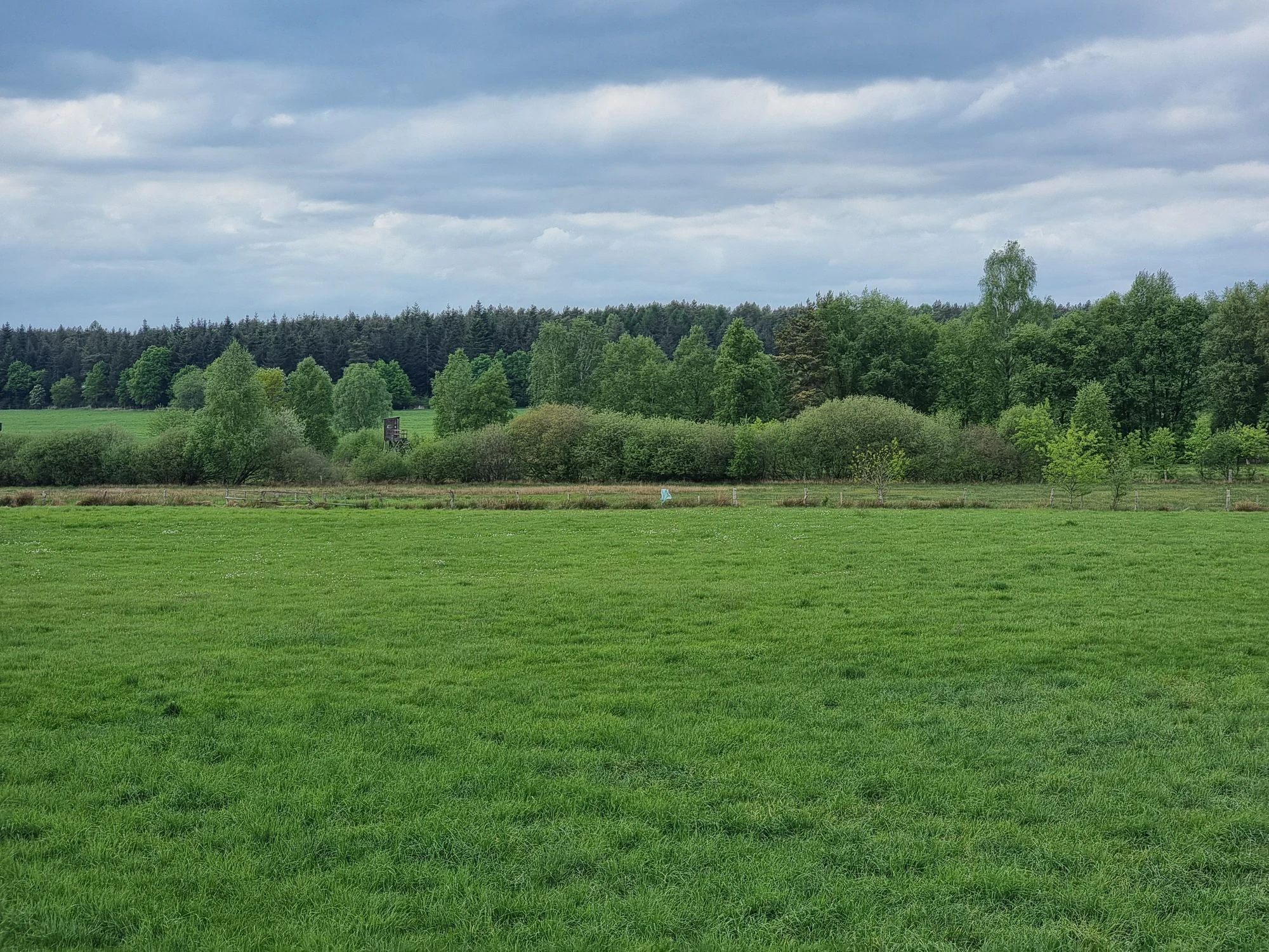
A wide shot of a green grassy meadow with a line of trees and bushes in the background under a cloudy sky.
A view across the green meadows toward the tree line at Waller Moor.

Waller Moor history and protected-area timeline

The formal protection history of Waller Moor begins on 16 December 1985, when the area was declared a nature reserve (Naturschutzgebiet) under the designation NSG LÜ 133.

Before that designation, the site had been shaped for a long period by human use. The original raised bog ecosystem was altered through drainage and peat cutting, both typical land-use interventions in the north German plain where peatlands historically provided fuel and soil amendments for nearby communities. These interventions changed the hydrology and vegetation of the site over time, turning what was once a continuously waterlogged bog into a partly drained, broken landscape.

The protection designation marked a shift toward active conservation management, with rewetting introduced as a central restoration strategy. The intent has been to halt the loss of bog-forming conditions and to allow peat-building vegetation communities to gradually recover. The presence of small ponds in the eastern part of the reserve and the maintained extensive grassland buffer surrounding the bog core both reflect the practical measures used to support this longer-term restoration goal.

Although the reserve is small, its establishment fits into the broader 1980s wave of formal nature protection in Lower Saxony, when many comparable peatland and wetland sites in agricultural landscapes were brought under official protection to preserve what remained of their ecological character.

Waller Moor landscape and geographic character

Waller Moor sits in a gently undulating section of the Lower Saxon countryside north of the village of Völkersen, where the flat to slightly rolling terrain typical of the region provides space for small but distinct habitat contrasts. Elevations across the reserve range roughly between 28 and 39 meters above sea level, placing it well within the lowland character of the area.

The landscape consists of several overlapping elements. At its core lies a recovering raised bog, fringed on the west, south, and east by extensive grassland that has been deliberately managed in a low-intensity way to shield the bog from the more intensively farmed fields beyond. To the north, low woodland dominated by birch and pine edges into the Spanger Holz, a larger forest that gives the reserve part of its geographic context.

In the eastern portion of the reserve, several small ponds add open water to the otherwise boggy and wooded landscape. The hydrology of the area is summarized by the fact that water from the moor ultimately drains into the Alte Aller, an older channel of the Aller river system, linking the small site into the broader regional water network.

Waller Moor ecosystems, habitats, and plant life

The ecological character of Waller Moor centers on a recovering raised bog habitat that retains recognizable features of the original peatland ecosystem despite its disturbed history. The mosaic of bog, woodland, ponds, and buffer grassland creates several distinct micro-habitats within a relatively compact area.

In the northern part of the reserve, low woodland made up primarily of birch and pine forms a transitional zone between the higher, drier Spanger Holz forest and the wet bog core. This wooded fringe provides structural diversity and habitat for a range of bog- and forest-associated species.

The western part of the reserve hosts the most distinctive bog flora, where Molinia grass, cross-leaved heath, and a suite of specialist bog plants coexist. Notable plant species recorded here include bog lily (Moorlilie), marsh gentian (Lungen-Enzian), and bog rosemary, alongside orchids that depend on the particular hydrology and low nutrient status still maintained in places across the site.

In the east, small ponds and wetter margins add an aquatic dimension to the otherwise terrestrial bog mosaic. The surrounding extensive grassland plays an important ecological role by acting as a low-disturbance buffer between the bog's sensitive core and the conventional farmland that borders the reserve to the south and west.

Waller Moor wildlife and species highlights

Waller Moor is best understood as a habitat-focused rather than a flagship-species wildlife site. Its specific significance lies in supporting communities of bog-adapted plants and the invertebrate and small vertebrate fauna that depend on them, rather than hosting large charismatic mammals.

The mixture of birch-pine fringe woodland, recovering open bog, ponds, and buffer grassland offers niches for typical north German peatland wildlife, including the bird, insect, and amphibian groups associated with such habitats. The presence of small ponds in particular provides breeding and feeding habitat for amphibians and aquatic invertebrates that benefit from the rewetting measures applied across the site.

The extensive grassland surrounding the bog not only buffers the reserve from agricultural pressures but also contributes modest open-land wildlife value, supporting insect and bird species typical of low-intensity meadow management.

Waller Moor conservation status and protection priorities

Waller Moor matters from a conservation standpoint because it represents one of the many small but ecologically distinctive raised bog fragments in the Lower Saxon countryside that have been preserved against ongoing habitat loss. Peatlands across northern Germany have been heavily reduced through drainage and peat extraction, making surviving bog sites and their restoration particularly important for biodiversity and for the broader climate-relevant function of peat-forming ecosystems.

The protection status of NSG LÜ 133 provides a formal legal framework for safeguarding the site, and the designation places it under the oversight of the Verden district as the responsible lower nature conservation authority. The presence of NLWKN as the supervising state-level authority reinforces the linkage between local site management and regional conservation policy.

Active restoration through rewetting is the core conservation strategy at Waller Moor. By raising the water table and supporting the re-establishment of bog vegetation, the management approach aims to restore conditions suitable for peat formation and for the characteristic bog flora such as bog lily, marsh gentian, and bog rosemary. The buffer grassland surrounding the core reduces the risk of nutrient and pollutant inputs from neighboring agriculture, which is a continuing pressure for many peatland sites embedded in working farmland.

Top sights and standout views in Waller Moor

Waller Moor stands out for the combination of a formally protected raised bog, active rewetting management, and an extensive grassland buffer that sets it apart from neighboring farmland.

The reserve is also notable within the Verden district for its integration into the larger Spanger Holz landscape, where woodland, bog, ponds, and meadows come together in a compact area that captures many of the defining features of peatland conservation in Lower Saxony.

Monthly climate preview

Long-term monthly temperature and precipitation records for Lower Saxony

Waller Moor Climate Normals and Measured Annual Temperature Patterns

Representative coordinate records show measured annual temperature and precipitation fluctuations across twelve distinct monthly intervals. Complete monthly normals provide detailed baseline data for tracking long-term weather by month across the terrain.
Annual mean9 °C
1 °C18 °C
Jan
Feb
Mar
Apr
May13°
Jun16°
Jul18°
Aug18°
Sep14°
Oct
Nov
Dec
Warmest month
July

18.1 °C

Coolest month
January

0.7 °C

Wettest month
July

2.5 mm/day

Driest month
April

1.4 mm/day

Park location guide

Geography guide, regional context, and park location map for Waller Moor

Waller Moor park geography, regions, and map view in Germany

Understand where Waller Moor sits in Germany through a broader geographic reading of the surrounding landscape, nearby location context, and its mapped position within the national park landscape.

How Waller Moor fits into Germany

Germany is a federal republic in Western and Central Europe with a population of over 83 million across sixteen constituent states. It is Europe's largest economy by nominal GDP and a major global exporter and importer. The capital is Berlin, and the country borders Denmark, Poland, Czech Republic, Austria, Switzerland, France, Luxembourg, Belgium, and the Netherlands.

Wider geography shaping Waller Moor in Germany

Germany is located in Western and Central Europe, spanning 357,022 km². It borders Denmark to the north, Poland and the Czech Republic to the east, Austria and Switzerland to the south, and France, Luxembourg, Belgium, and the Netherlands to the west. The country has coastlines on the Baltic Sea and North Sea to the north, with the Alps located in the southern region.

Map view of Waller Moor

Use this park location map to pinpoint Waller Moor in Germany, understand its exact geographic position, and read its mapped placement within the surrounding landscape more clearly.

Pigeon | © OpenStreetMap contributors

Location context for Waller Moor

Lower Saxony

Visual exploration of recovering bog habitats, woodland edges, and lowland terrain

Waller Moor Photos, Landscapes, and Protected Area Scenery

Visual documentation captures the recovering raised bog habitats, birch fringed woodlands, and open water ponds defining Waller Moor. Photographic records help researchers and visitors examine the protected landscape character, terrain features, and peatland regeneration efforts across the reserve.

A wide shot of a green grassy meadow with a line of trees and bushes in the background under a cloudy sky.

Park atlas

Discover related lowland reserves and connected wetland landscapes across the Verden district

Exploring Parks Near Waller Moor and Surrounding Lower Saxony Protected Areas

Continue geographic discovery by comparing Waller Moor with other regional nature reserves and wetland habitats throughout Lower Saxony. Examining adjacent protected landscapes provides broader context for peatland conservation and lowland river basin geography.
Nature reserveLower Saxony
About 5 km away#1 closest

East

Wolfsgrund Nature Reserve: Geographic Overview of Protected Heathlands in Lower Saxony

Inland dune topography and alder swamp forest ecology

Wolfsgrund represents a core protected area in Lower Saxony, defined by its unique inland dune geography and the narrow valley of the Everser Bach. The reserve encompasses a diverse ecological gradient, protecting sensitive dry heath, moist heathlands, and alder swamp forests that serve as a crucial refuge for regional biodiversity. This structured geographic overview highlights the terrain transitions and conservation significance of this essential German nature reserve.

Area
0.458 km²
Established
1977
IUCN
IV
Nature reserveNiedersachsen
About 5.3 km away#2 closest

Southeast

Waller Flachteiche Nature Reserve: Exploring the Geography of Protected Landscapes in Niedersachsen

Mapped habitats of a former sand quarry wetland

Waller Flachteiche is a state-recognized nature reserve covering over 22 hectares of sandy, lowland terrain in Germany. The protected area offers a look at a recovered industrial site, where periodically drying ponds and diverse scrubland create a specialized habitat for rare amphibians and wetland flora. Its defined boundaries highlight a critical Natura 2000 component within the broader Niedersachsen region.

Area
0.227 km²
Established
2018
IUCN
IV
Nature reserveLandkreis Rotenburg (Wümme)
About 5.4 km away#3 closest

Northeast

Wümmeniederung mit Rodau, Wiedau und Trochelbach: Protected Wetland and Heath Landscape

Regional geography and floodplain connectivity in Landkreis Rotenburg

This nature reserve protects a sprawling lowland landscape characterized by the Wümme, Rodau, Wiedau, and Trochelbach rivers. The terrain features a mosaic of near-natural meandering streams, species-rich wet meadows, and rare raised bog remnants, providing a comprehensive overview of northern German lowland ecology.

Area
28.96 km²
Established
2020
IUCN
IV
Relief
Lowland
Nature reserveLower Saxony
About 5.9 km away#4 closest

East

Wedeholz Nature Reserve: Geographic Overview of Lower Saxony Protected Forest Landscapes

Ancient oak forests, Geest terrain, and protected wetland habitats

Wedeholz represents a dense forest conservation area in Lower Saxony, defined by its mature oak and beech communities. The reserve terrain transitions from dry sandy Geest soils to delicate pine swamp forests and floating bogs, supporting a high density of deadwood-dependent species and woodland biodiversity within a compact, protected boundary.

Area
1.83 km²
Established
2019
IUCN
IV
Relief
Upland
Nature reserveLower Saxony
About 14 km away#5 closest

North

Wiestetal Nature Reserve: Mapping the Wieste Stream and Riparian Habitat Corridor

Protected floodplain geography in Lower Saxony, Germany

Wiestetal acts as a critical nature reserve between Mulmshorn and Ottersberg, protecting the unique ecological character of the Wieste lowland stream. The area is defined by its meandering water channels, flooded sand quarry ponds, and diverse forest edges that sustain local biodiversity. This protected landscape offers a detailed look at the interplay between glacial sand deposits and the vibrant aquatic ecosystems of Northern Germany.

Area
3.82 km²
Established
2013
IUCN
IV
Relief
Upland
Nature reserveLower Saxony
About 15 km away#6 closest

Northeast

Stellmoor und Weichel: Geographic Profile of a Lower Saxony Nature Reserve

Protected geest woodlands and peat-bog mosaic landscapes

Examine the territorial boundaries and ecological features of Stellmoor und Weichel. Located on the flat geest ridge of Northern Germany, this reserve maps the transition from managed deciduous woodland to complex mire, willow thicket, and bog-fringe water systems, maintaining a long-standing natural forest reserve status.

Area
2.18 km²
Established
2018
IUCN
IV
Nature reserveLower Saxony
About 17 km away#7 closest

Southeast

Verdener Moor Nature Reserve: Geographic Atlas and Protected Area Context

Preserving raised bog ecosystems in Lower Saxony, Germany

Located in the municipality of Kirchlinteln, Verdener Moor functions as a protected nature reserve that demonstrates lowland peatland conservation. The landscape features a distinct mosaic of open water resulting from historical peat extraction, wet heath, and rewilded forest edges. This site offers valuable insight into the restoration of bog habitats through rewetting and bush removal within the broader geography of Lower Saxony.

Area
0.91 km²
Established
1989
IUCN
IV
Relief
Lowland
Nature reserveLandkreis Rotenburg (Wümme)
About 17 km away#8 closest

North

Westliches Borchelsmoor Nature Reserve: Geographic Profile and Protected Bog Landscape

A preserved peatland fragment in the Landkreis Rotenburg district.

Located in northern Lower Saxony, Westliches Borchelsmoor represents a significant remnant of the historical Borchelsmoor raised bog. The reserve showcases a complex topography of old drainage lines and birch woodland, providing a clear window into the ecological transition of modified moorland. This site serves as a core component of the local wetland mosaic and offers valuable insights into ongoing peatland restoration and bog conservation.

Area
1.25 km²
Established
2010
IUCN
IV
Relief
Lowland

Common questions about visiting, size, designation, and location context for Waller Moor

Waller Moor FAQs for park facts, access, geography, and protected area context

Find quick answers about Waller Moor, including protected-area facts, park geography, trail and visitor context, and how the park fits into its surrounding country and regional landscape.
MoriAtlas Explorer

Continue Your Protected Areas Search Across the Global Atlas

Deepen your exploration by continuing the structured search for national parks and protected areas worldwide. Utilize the comprehensive filtering capabilities to compare different conservation landscapes and refine your understanding of global park geography. Discover more about the distribution and characteristics of protected natural areas.

Global natural geography