
Mori Atlas logo
Nature reserveWalterbachtal

A compact protected area featuring mapped stream dynamics, valley meadows, and ancient forest slopes

Walterbachtal Nature Reserve: Exploring the Stream Valley Landscapes of the German Deister Range

(Naturschutzgebiet Walterbachtal)

Walterbachtal represents a significant nature reserve located in Lower Saxony, Germany, nestled within the forested hills of the Deister range in the Weserbergland. This protected area centers on a near-natural stream channel that traverses a mosaic of floodplain meadows and lush, steep-sided deciduous slopes. The site functions as a vital refuge, where the interplay of cool aquatic environments, open grasslands, and dense woodland creates a diverse habitat for bird and amphibian populations.

nature reservestream valleybrook habitatsalmonid watersfloodplain forestdeciduous forest
A flat-design, digital illustration of a scenic mountain valley featuring a waterfall on the left, a river winding through a grassy foreground, evergreen trees on the right, and distant plateaus under a large sun.

Walterbachtal

Nature reserve

Park overview

Structured park overview, official facts, and landscape profile for Walterbachtal

Walterbachtal park facts, protected area profile, and essential visitor context

Review the core facts for Walterbachtal, including designation, size, terrain, visitor scale, habitats, and operating context in one park-focused overview.

About Walterbachtal

Walterbachtal is a small but ecologically focused nature reserve in the Weserbergland region of Lower Saxony. It covers a stretch of the Walterbach, a typically two to five meter wide stream, along with the roughly fifty to one hundred meter wide valley floor that runs beside it, and the moderately steep slope forests of the Deister that overhang the brook on either side. The elevation across the protected area ranges from about 109 to 158 meters above sea level, placing it firmly within the lower, well-wooded band of the Deister rather than its more exposed upper ridges.

The reserve's centerpiece is the Walterbach itself, an essentially natural low-mountain stream with partially steep banks, gravel bars, plunge steps, and deeper pools cut into its bed. This channel structure, together with the surrounding alder floodplain forest that lines much of the watercourse, gives the valley a markedly humid and sheltered character. Because the brook supports populations of brown trout and bullhead, it is officially counted among the region's salmonid waters, and the varied channel morphology offers the kind of microhabitats that such species depend on.

Above the narrow floodplain, the broad valley floor is dominated by green land that has been kept open through traditional use as pasture. These meadows, with their transitions to wetter seepage zones near the stream, contrast vividly with the surrounding slope forests. The moderately steep valley sides are clothed in beech forest and oak-hornbeam forest, broken by springs and flushes that support a rich display of spring-flowering plants. Together, watercourse, valley-flora meadow, and slope forest represent a compact but unusually complete cross-section of the natural and semi-natural habitats typical of the lower Deister.

Administratively and ecologically, Walterbachtal sits within the larger framework of the Naturpark Weserbergland Schaumburg-Hameln, a landscape-level park that links many small protected sites across the region. As a nature reserve under the German Naturschutzgesetz, it carries stricter protection than the surrounding Naturpark and is intended to safeguard the long-term integrity of its habitats and species rather than to serve as a public recreation area. The site is recognized internationally through the World Database on Protected Areas under ID 166165 and is classified as an IUCN Category IV Habitat/Species Management Area, reflecting its role in conserving specific habitats and species rather than a large-scale ecosystem.

Quick facts and research context for Walterbachtal

Walterbachtal is a designated nature reserve (Naturschutzgebiet) in Lower Saxony, identified by the code NSG HA 124. It lies within the Naturpark Weserbergland Schaumburg-Hameln and is administered jointly by the counties of Schaumburg and Hameln-Pyrmont. The site has been protected since 24 December 1987 and is managed under the oversight of the Lower Saxony agency for water management, coastal protection, and nature conservation (NLWKN).

The reserve straddles two administrative regions: the larger portion lies in the municipality of Lauenau and the community of Messenkamp in Schaumburg, while a smaller area falls within the city of Bad Münder am Deister in Hameln-Pyrmont. The site is recognized internationally through the World Database on Protected Areas under ID 166165 and is classified as an IUCN Category IV Habitat/Species Management Area.

Protection and recognition

Documented terrestrial protection scope and baseline conservation data

Walterbachtal Protection Status and International Recognition Records

Walterbachtal maintains a recorded terrestrial protection scope within the global protected area registry without assigned international recognition designations. Conservation tracking covers baseline administrative parameters, management jurisdiction, and official database indexing.

Protection details

Protection scope
Terrestrial
Transboundary protection
No
WDPA ID
166165
Park context

Deeper park guide and search-rich context for Walterbachtal

Walterbachtal history, landscape, wildlife, and travel context

Explore Walterbachtal through its history, landscape character, ecosystems, wildlife, conservation priorities, cultural context, and seasonal travel timing in a structured park guide built for atlas discovery and search intent.

Why Walterbachtal stands out

Walterbachtal is best known for protecting a near-natural section of a small Deister stream, the Walterbach, together with the still traditionally used wet meadows of its narrow valley floor. The reserve's value rests on the close interplay of a structurally diverse brook, surrounding old deciduous woodland on slopes, and open grassland that has been shaped by long-standing grazing use. The stream itself carries trout and bullhead, which places it among the recognized salmonid waters of the region, while the gravel beds and pools of its channel and the seepage areas on the wooded slopes provide habitat for amphibians and a wide range of breeding, resting, and foraging birds. The reserve therefore functions as a compact refuge for stream and meadow biodiversity within an otherwise heavily used low-mountain landscape.
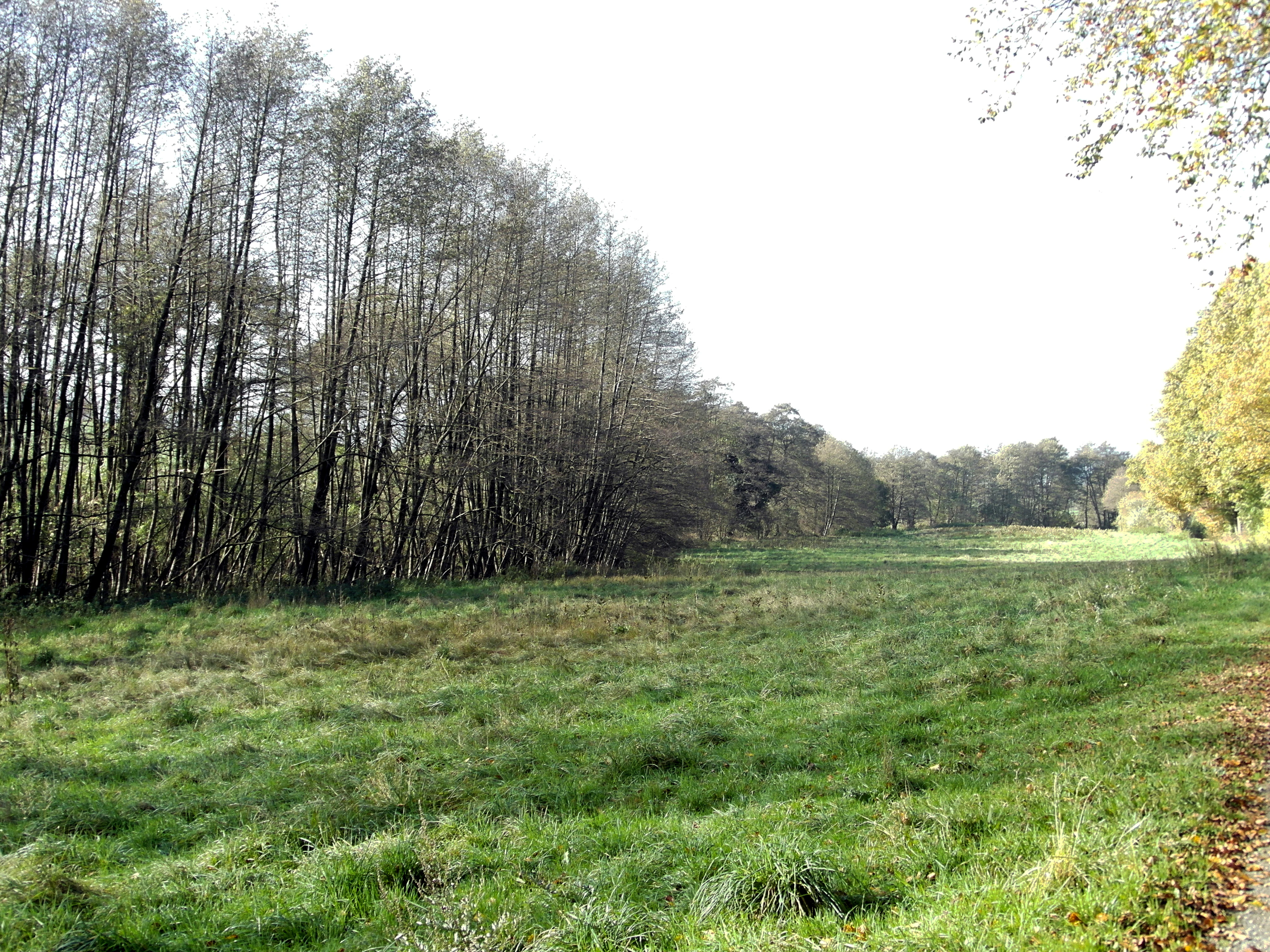
A green meadow landscape in Walterbachtal, bordered by a dense line of slender, leafless trees on the left, under a bright, overcast sky.
A grassy meadow bordered by a line of trees in the Walterbachtal nature reserve.

Walterbachtal history and protected-area timeline

The decision to formally protect the Walterbachtal was taken on 24 December 1987, when the area was designated as a Naturschutzgebiet under the nature conservation law of Lower Saxony. This designation formalized the long-standing ecological and cultural value of the valley, where traditional pasture use along the stream had coexisted for generations with near-natural deciduous forest on the slopes.

After designation, the reserve was given the official identifier NSG HA 124 and divided between the two counties whose territory it crosses, with the larger portion falling to Landkreis Schaumburg and the smaller to Landkreis Hameln-Pyrmont. Management responsibility was assigned to the respective lower nature conservation authorities of these two counties, with technical oversight from the Lower Saxony agency for water management, coastal protection and nature conservation (NLWKN).

Internationally, the site is catalogued in the World Database on Protected Areas under ID 166165. Its international classification as an IUCN Category IV Habitat/Species Management Area reflects the German designation's intent, which is the active conservation of particular habitats and species rather than the protection of an entire natural landscape.

Walterbachtal landscape and geographic character

The landscape of Walterbachtal is defined by a clear vertical sequence running from stream to valley floor to slope. At its base flows the Walterbach, a narrow, dynamic low-mountain stream that has carved a small but varied channel with gravel bars, plunge steps, plunge pools, and partially overhanging banks. The brook is typically only a few meters wide, but its immediate floodplain broadens out into a valley lowland roughly fifty to one hundred meters across that still retains the open character of a wet meadow.

Above the floodplain, the reserve rises into the moderate slopes of the Deister, a wooded low mountain range that forms the western backdrop to the city of Hannover. Across the protected area, elevation climbs from about 109 meters to about 158 meters above sea level. The slopes are not dramatic, but they are steep enough to remain unsuitable for cultivation, which has allowed continuous forest cover to persist here.

The visual contrast within the reserve is therefore strong: a narrow, shadowy corridor of water and broad-leaved woodland along the stream, an open, sunlit strip of meadow in the valley floor, and then a continuous green wall of deciduous forest climbing the slopes on either side. This mosaic of water, meadow, and forest is one of the defining scenic qualities of the Walterbachtal.

Walterbachtal ecosystems, habitats, and plant life

Ecologically, Walterbachtal is notable for packing a surprising diversity of habitats into a small footprint. The stream corridor supports alder-dominated floodplain forest along much of its length, a vegetation type adapted to periodic flooding and to permanently moist soils. The brook itself provides structured, near-natural aquatic habitat with a mix of riffles, pools, and gravel beds.

The valley floor is shaped by traditionally used, species-rich green land, kept open as pasture rather than converted to cropland or left to scrub over. This maintains the open meadow character that contrasts with the surrounding forest, and supports meadow flora adapted to seasonal flooding and to spring-fed seepage.

The wooded slopes are dominated by beech forest and oak-hornbeam forest, classic Central European deciduous woodland types that thrive on the calcareous and loamy soils of the Deister. Within this forest matrix, spring-fed flushes and seepage zones represent particularly valuable microhabitats. These moist, nutrient-rich areas sustain rich populations of spring-flowering woodland plants and contribute to the botanical diversity of the reserve.

Walterbachtal wildlife and species highlights

Wildlife is one of the central conservation reasons for the protection of Walterbachtal. The Walterbach carries self-sustaining populations of brown trout and bullhead, two characteristic species of cool, well-oxygenated low-mountain streams. Their presence is one of the criteria by which the brook is officially recognized as a salmonid water.

The valley floor and slopes together provide habitat for amphibians, which use the stream, its margins, and the seepage zones on the slopes as breeding and refuge habitat. The reserve is also described as an important breeding, resting, and foraging area for numerous bird species, which benefit from the close proximity of water, open meadow, and forest. The combination of dense slope forest, open wet grassland, and a near-natural stream supports very different bird communities within a very short distance.

Walterbachtal conservation status and protection priorities

The conservation significance of Walterbachtal lies in its role as a small, focused refuge for habitats and species that have become scarce in the broader countryside of Lower Saxony. The protection of a near-natural stream corridor with its associated floodplain forest and the preservation of traditionally used wet meadows on the valley floor together represent a combination that is increasingly rare in this densely settled part of Germany.

As an IUCN Category IV Habitat/Species Management Area, the reserve is specifically oriented toward the conservation of particular habitats and species rather than the protection of a complete natural landscape. Its management is overseen by the Lower Saxony water and nature conservation agency (NLWKN), which provides technical guidance, while the day-to-day regulatory authority rests with the lower nature conservation authorities of the counties of Schaumburg and Hameln-Pyrmont.

The site is part of the broader Naturpark Weserbergland Schaumburg-Hameln, but as a formal nature reserve it carries more stringent restrictions than the surrounding park. These restrictions are intended to keep the brook, its floodplain, and the slope forest intact, to maintain the meadow character of the valley floor, and to ensure that the populations of trout, bullhead, amphibians, and breeding birds that depend on the area can persist in the long term.

Walterbachtal cultural meaning and human context

Walterbachtal reflects the long history of small-scale, low-intensity land use that has shaped the valleys of the Deister over centuries. The green land along the Walterbach has been kept open as pasture for generations, and it is precisely this continuing traditional use that has preserved the open character of the valley floor against the natural tendency of Central European low-mountain valleys to revert to forest when grazing ceases.

The reserve also lies within the broader Weserbergland, a region whose cultural identity is closely bound to its small valleys, wooded ridges, and traditional mixed land use. Although Walterbachtal itself is not a major cultural landmark, it is a representative example of the kind of valley landscape that has historically supported small farming communities around Springe, Lauenau, and Bad Münder am Deister, and that continues to define the regional landscape today.

Top sights and standout views in Walterbachtal

Walterbachtal's most distinctive highlight is the close coexistence, within a single short valley, of a near-natural trout stream, traditionally grazed wet meadows, and continuous beech and oak-hornbeam forest. Few other reserves in the Weserbergland combine these three elements so compactly.

The reserve is also unusual in the clarity of its habitat transitions: visitors moving from the stream edge up onto the slopes pass from alder floodplain forest to open meadow to closed deciduous forest in a matter of meters, with springs, seepage zones, and gravel bars punctuating the transitions. The presence of brown trout and bullhead in the brook, of amphibian habitat along the banks, and of a rich breeding bird community across the valley underlines how much ecological value can be packed into a small, locally protected site.

Best time to visit Walterbachtal

Because Walterbachtal is a quiet, lightly visited nature reserve rather than a tourist destination, the question of when to visit is shaped mainly by what one wants to experience rather than by peak-season crowds. Spring is particularly rewarding, when the spring-flowering plants on the slope springs are at their peak and the bird community along the valley is most active.

Late spring and early summer are also a good time to see the wet meadows of the valley floor at their most floristically diverse, while the slopes are in fresh leaf and the stream is generally well supplied with water. Autumn brings leaf color to the beech and oak forests and a different, more contemplative character to the valley. In winter, the bare trees make the structure of the channel and the contrast between open meadow and forested slope easier to observe, though paths may be wet and slippery.

Monthly climate preview

Long-term representative monthly temperature and precipitation data for Walterbachtal

Walterbachtal Climate Normals and Annual Temperature Rhythm

Representative coordinates record long-term temperature ranges and precipitation rates across twelve monthly observation points for Walterbachtal. Analyzing the complete monthly climate normals reveals detailed seasonal shifts in average minimum and maximum temperatures.
Annual mean9 °C
1 °C18 °C
Jan
Feb
Mar
Apr
May13°
Jun16°
Jul18°
Aug18°
Sep14°
Oct10°
Nov
Dec
Warmest month
July

18.4 °C

Coolest month
January

0.6 °C

Wettest month
July

2.4 mm/day

Driest month
April

1.4 mm/day

Park location guide

Geography guide, regional context, and park location map for Walterbachtal

Walterbachtal park geography, regions, and map view in Germany

Understand where Walterbachtal sits in Germany through a broader geographic reading of the surrounding landscape, nearby location context, and its mapped position within the national park landscape.

How Walterbachtal fits into Germany

Germany is a federal republic in Western and Central Europe with a population of over 83 million across sixteen constituent states. It is Europe's largest economy by nominal GDP and a major global exporter and importer. The capital is Berlin, and the country borders Denmark, Poland, Czech Republic, Austria, Switzerland, France, Luxembourg, Belgium, and the Netherlands.

Wider geography shaping Walterbachtal in Germany

Germany is located in Western and Central Europe, spanning 357,022 km². It borders Denmark to the north, Poland and the Czech Republic to the east, Austria and Switzerland to the south, and France, Luxembourg, Belgium, and the Netherlands to the west. The country has coastlines on the Baltic Sea and North Sea to the north, with the Alps located in the southern region.

Map view of Walterbachtal

Use this park location map to pinpoint Walterbachtal in Germany, understand its exact geographic position, and read its mapped placement within the surrounding landscape more clearly.

Pigeon | © OpenStreetMap contributors

Explore detailed visual records of Walterbachtal, featuring stream corridors and wooded slope mosaics.

Walterbachtal Photos and Landscape Scenery: Visualizing Stream Valleys and Protected Habitats

Visual records capture the distinctive terrain of Walterbachtal, ranging from shaded stream channels to sunlit floodplain meadows. Examining these protected area images clarifies how local topography, deciduous woodland, and valley wetlands form a compact ecological refuge.

A green meadow landscape in Walterbachtal, bordered by a dense line of slender, leafless trees on the left, under a bright, overcast sky.

Park atlas

Compare adjacent Weserbergland reserves and regional low-mountain terrain.

Explore Other Parks Near Walterbachtal and Surrounding Protected Areas

Browse nearby protected landscapes and stream valley reserves that share similar ecological traits with Walterbachtal. Extending the regional comparison reveals how surrounding low-mountain terrain and river corridors connect across Lower Saxony.
Protected areaRegion Hannover
About 13 km away#1 closest

North

Mausohr-Wochenstube bei Barsinghausen: Protected Habitat and Regional Landscape Context

A vital Natura 2000 maternity site in Region Hannover

Examine the geography of Mausohr-Wochenstube bei Barsinghausen, an essential protected area for greater mouse-eared bats. This site showcases the intersection of architectural heritage and natural conservation, relying on the adjacent river corridors and agricultural landscapes of the Region Hannover to sustain its vital ecological function within Lower Saxony.

Area
0.001 km²
Established
2004
Relief
Lowland
Climate
Temperate
Natural monumentRheinland-Pfalz
About 17 km away#2 closest

Southeast

Steinbruch Holzmühle Natural Monument: Protected Limestone Landscapes and Geological Map

Mapping the geological strata and amphibian habitats of the Osterwald hills.

Investigate the geological significance and managed ecological profile of Steinbruch Holzmühle. This site features preserved Kimmeridgian limestone formations and restored habitats that provide a unique case study in post-industrial conservation within the local regional hill network.

Watercolor illustration depicting a landscape with soft green hills, forest edges, and distant purple-hued mountains.
Protected areaRegion Hannover
About 17 km away#3 closest

East

Binnensalzstelle am Kaliwerk Ronnenberg: Mapped Protected Area and Industrial Landscape Context

A rare inland saline ecosystem in Region Hannover

Investigate the Binnensalzstelle am Kaliwerk Ronnenberg, a protected area in Region Hannover defined by its unusual saline conditions. This site presents a concentrated intersection of industrial history and ecological rarity, showcasing how potash mine tailings foster salt-dependent habitats in a inland landscape.

Area
0.017 km²
Established
2004
Relief
Lowland
Climate
Temperate
Watercolor painting of a rolling, forested ridge landscape in shades of green, yellow, and soft pink.
Protected areaLower Saxony
About 17 km away#4 closest

Southeast

Ith Protected Area: Mapped Limestone Ridge Geography and Geological Features

Continuous limestone cliff formations in the Lower Saxony uplands

The Ith stands as a major geological landmark in Lower Saxony, featuring a 22 kilometer spine of Upper Jurassic limestone. This protected area preserves a unique collection of cliff crags, dense beech forests, and limestone-dependent plant communities that span the districts of Hameln-Pyrmont and Holzminden.

Relief
Mountain
Climate
Temperate
Access
Access unknown
Scope
Terrestrial
Nature reserveLower Saxony
About 19 km away#5 closest

East

Zigeunerwäldchen Nature Reserve: A Detailed Geographic Atlas of the Haller River Floodplain

Protected riparian forest boundaries in Lower Saxony

Zigeunerwäldchen is a protected nature reserve in Lower Saxony that preserves a vital fragment of the Haller river floodplain. The landscape is defined by willow-dominated alluvial forest, marshy clearings, and thick stands of sedge. By maintaining these natural water-influenced terrains, the reserve provides a rare glimpse into the historical floodplain architecture of the Calenberger Land region.

Area
0.15 km²
Established
1986
A wide panoramic watercolor illustration showing a winding river or stream flowing through a landscape of green pine trees and pink flowering bushes under a pale sky.
Nature reserveRegion Hannover
About 21 km away#6 closest

North

Wadebruch Nature Reserve: Geographic Analysis of a Lower Leine Floodplain Protected Area

A dense mosaic of alder swamps, oxbow channels, and sandy terrace forest in Germany.

Wadebruch serves as a compact, ecologically rich example of a lower Leine floodplain environment. Located in the Hannover Region, this protected site preserves a historic river meander, including an aging oxbow and alder swamp forest, contrasted against steep sandy banks. The site provides essential insights into the natural river patterns that once characterized this part of Lower Saxony.

Area
0.16 km²
Established
1985
IUCN
IV
Relief
Lowland
Nature reserveLower Saxony
About 22 km away#7 closest

North

Steinhuder Meer mit Randbereichen: Protected Nature Reserve and Wetland Geography

Lowland lake, fen meadows, and bog ecosystems in Lower Saxony

Steinhuder Meer mit Randbereichen stands as a primary conservation site in northwestern Germany. The protected landscape combines a vast, shallow lowland lake with extensive reed belts and peatland remnants, creating a complex wetland gradient that defines the regional geography of the Weser-Aller lowlands.

Area
53.71 km²
Established
2004
Nature reserveRegion Hannover
About 23 km away#8 closest

East

Sundern Nature Reserve and Floodplain Forest Landscapes of Region Hannover

Historic river meander and alluvial habitat preservation

Sundern represents a critical fragment of the historic Leine river floodplain in the Region Hannover. This nature reserve features a complex mosaic of moist backwaters and dry deciduous woodlands, including old-growth oak-hornbeam stands. The area is defined by its glacial valley setting, where centuries of sediment accumulation have shaped a distinct, slightly elevated landscape mosaic that remains vital for regional conservation.

Area
0.504 km²
Established
1931
IUCN
IV
Relief
Lowland

Common questions about visiting, size, designation, and location context for Walterbachtal

Walterbachtal FAQs for park facts, access, geography, and protected area context

Find quick answers about Walterbachtal, including protected-area facts, park geography, trail and visitor context, and how the park fits into its surrounding country and regional landscape.
MoriAtlas Explorer

Continue Your Protected Areas Search Across the Global Atlas

Deepen your exploration by continuing the structured search for national parks and protected areas worldwide. Utilize the comprehensive filtering capabilities to compare different conservation landscapes and refine your understanding of global park geography. Discover more about the distribution and characteristics of protected natural areas.

Global natural geography