
Mori Atlas logo
Nature reserveWanhödener Moor

Mapping the protected raised bog terrain and coastal wetland ecosystems within Lower Saxony

Wanhödener Moor Nature Reserve: A Detailed Geographic Overview of Northern German Bog Landscapes

(Naturschutzgebiet Wanhödener Moor)

Wanhödener Moor stands as a significant protected nature reserve within the Westerwannaer Moorgeest of Lower Saxony, Germany. This site offers an instructive look at a surviving raised bog fragment situated in the flat coastal lowlands. Through its unique combination of uncultivated bog surface, regenerative birch woodland, and historical boundary channels, the reserve serves as a critical reference point for the ecological history of North Sea peatlands.

raised bogpeatlandmoorlandcoastal lowlandnature reserveLower Saxony
A digital illustration featuring a tall waterfall cascading between steep, rocky mountain cliffs into a valley with a stream, surrounded by evergreen and birch trees under a light sky.

Wanhödener Moor

Nature reserve

Park overview

Structured park overview, official facts, and landscape profile for Wanhödener Moor

Wanhödener Moor park facts, protected area profile, and essential visitor context

Review the core facts for Wanhödener Moor, including designation, size, terrain, visitor scale, habitats, and operating context in one park-focused overview.

About Wanhödener Moor

The Wanhödener Moor nature reserve lies in the coastal hinterland of Lower Saxony, southeast of the village of Nordholz, within the wider area of Wurster Nordseeküste. Although modest in extent, occupying roughly 39 hectares, it represents a carefully protected fragment of a formerly much larger raised bog landscape. Its low elevation, between one and four meters above sea level, places it firmly within the wetland-influenced terrain that characterizes much of the North German Plain, where the air carries Atlantic moisture and the soils are dominated by peat and other waterlogged deposits.

From a landscape perspective, the reserve sits in the Westerwannaer Moorgeest, a stretch of geest-adjacent moorland shaped by centuries of human intervention. Most of the original high bog in this area was drained and then cut for peat, transforming the terrain into a patchwork of fields, pastures, and woodland. Wanhödener Moor preserves one of the small sections that escaped full cultivation. Today, the site combines an uncultivated bog core, where peatland vegetation still persists, with surrounding margins that were converted to extensive grassland and now support grazing and hay-cutting at low intensity.

Ecologically, the site is a notable example of bog woodland dynamics. Birch and pine have established on the ungrazed and unmown sections of the bog, and conservation managers periodically remove parts of this woody growth, a process known as Entkusselung, to maintain open bog vegetation and prevent the trees from overshading the mosses and dwarf shrubs that define raised bog habitats. This active management reflects the recognition that, in a small reserve like this, simply leaving the land untouched would lead to gradual woodland takeover rather than the preservation of the open peatland community the site exists to protect.

Hydrologically, the reserve rests within a network of drainage channels that historically lowered water tables across the surrounding peat farmland. The local boundary ditch between Wanna and Wanhöden, which forms the reserve's eastern edge, channels excess water toward the Emmelke, a small tributary of the Medem that ultimately feeds the Elbe estuary system near the North Sea coast. Although the bog remains strongly influenced by these historic drainage patterns, the protected status of the site provides a framework within which land managers can work to stabilize or partially restore the moisture conditions essential to peatland ecology.

Together, its small size, its coastal-peatland character, and the layered history of extraction, cultivation, and protection make Wanhödener Moor a representative example of the many modest but ecologically valuable reserves that dot the Cuxhaven district. It is a place where the long transformation of the North German moorland landscape has left a compact, still-readable ecological remnant under formal conservation management.

Quick facts and research context for Wanhödener Moor

Wanhödener Moor is a designated nature reserve (Naturschutzgebiet) in Lower Saxony, Germany, located in the municipality of Wurster Nordseeküste within the district of Cuxhaven. The reserve has been protected since 16 July 1986 and is identified under the code NSG LÜ 145 by the Lower Saxon state agency NLWKN. It covers about 39 hectares in a landscape, the Westerwannaer Moorgeest, that lies only one to four meters above sea level, giving the bog a distinctly coastal, lowland character.

Protection and recognition

Examine documented terrestrial conservation metrics and official registry details

Wanhödener Moor Protection Status and International Recognition Record

Wanhödener Moor maintains a documented terrestrial protection status within official registry databases. Review verified management scope and international recognition records without extraneous travel details.

Protection details

Protection scope
Terrestrial
Transboundary protection
No
WDPA ID
166167
Park context

Deeper park guide and search-rich context for Wanhödener Moor

Wanhödener Moor history, landscape, wildlife, and travel context

Explore Wanhödener Moor through its history, landscape character, ecosystems, wildlife, conservation priorities, cultural context, and seasonal travel timing in a structured park guide built for atlas discovery and search intent.

Why Wanhödener Moor stands out

Wanhödener Moor is best known as a surviving remnant of a once extensive raised bog (Hochmoor) in the North German coastal lowlands. Much of the surrounding peatland has been cut for peat or drained for agricultural use, leaving this small reserve as one of the remaining places where original bog vegetation and bog-woodland transitions can still be observed. Its combination of uncultivated bog surface, regenerating birch and pine woodland, and species-rich extensively managed grassland margins gives it a layered ecological identity unusual for such a compact site near the North Sea. The area also illustrates the broader story of human use of northern German moorlands, providing a small but instructive window into centuries of peat cutting, drainage, and subsequent attempts to preserve what remains. While it is not a tourist landmark, it serves as a meaningful reference point for understanding the historic and ongoing relationship between people and peatlands along Germany's North Sea coast.
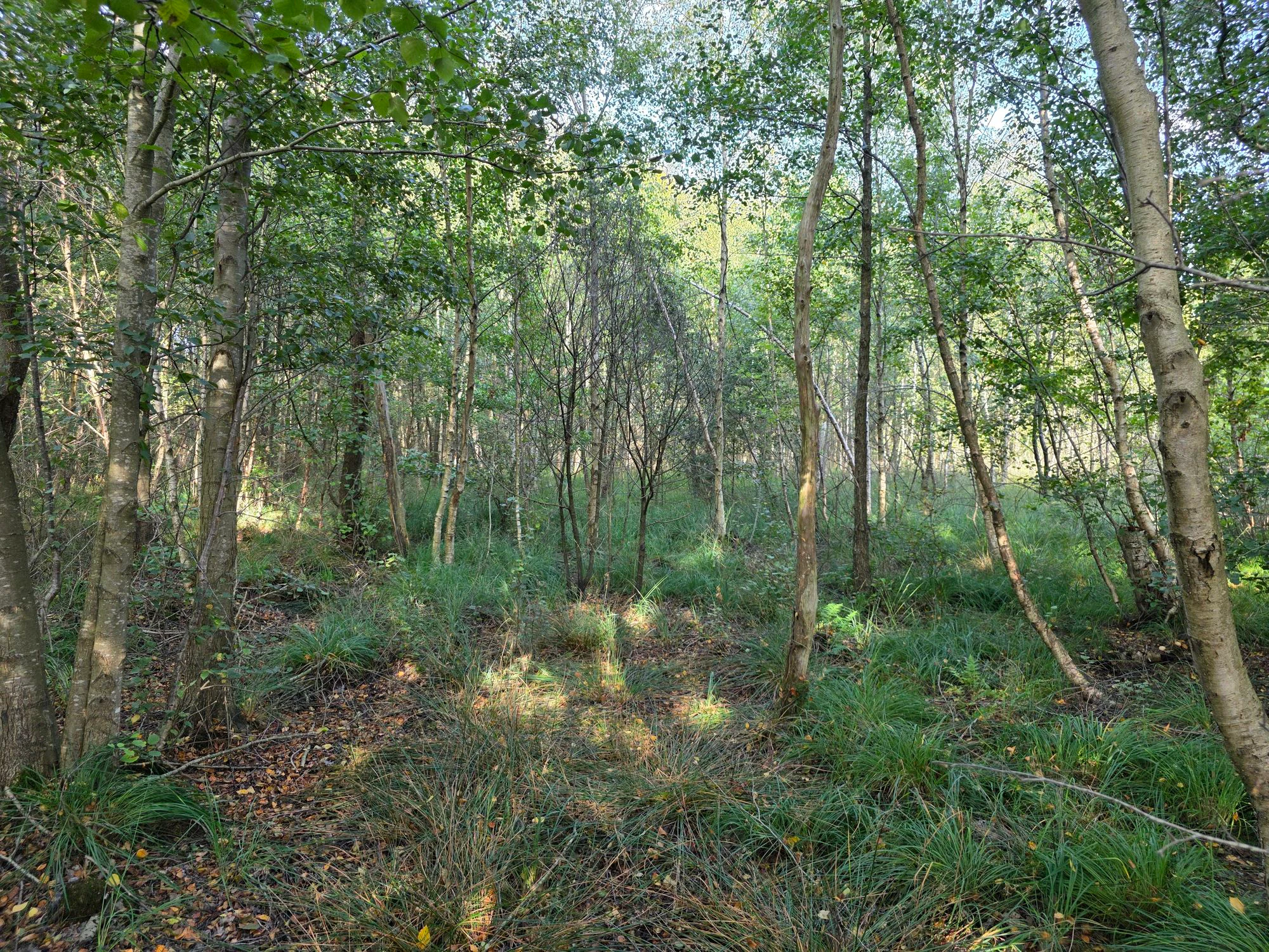
A dense patch of birch trees in a boggy, natural forest environment with dappled sunlight and low-lying ground vegetation.
A view into the wooded areas of the Wanhödener Moor nature reserve.

Wanhödener Moor history and protected-area timeline

The broader wetland landscape in which Wanhödener Moor sits has a long history of human use, with much of the original raised bog in the region drained and exploited for peat over centuries before modern conservation awareness emerged. As agricultural demand grew and peat became an important local fuel and soil amendment, large portions of the North German coastal peatlands were successively cut, drained, and converted into grassland or cropland.

Wanhödener Moor itself reflects this layered transformation. Once part of a more continuous area of raised bog across the Westerwannaer Moorgeest, it was reduced to a fragment as neighboring peatland sections were exploited. While some areas of the reserve were similarly drained and cultivated into grassland, a central core of the bog escaped full conversion, leaving behind a surviving piece of original peatland habitat that would later become the focus of formal protection.

The decisive moment in the site's modern history came on 16 July 1986, when the area was officially designated as a nature reserve (Naturschutzgebiet) under the designation NSG LÜ 145. Since then, the site has been managed by the district of Cuxhaven as the responsible lower nature protection authority, in cooperation with the Lower Saxon state agency NLWKN, with the explicit aim of protecting the remaining bog flora, maintaining open peatland surfaces against encroachment by birch and pine, and preserving the adjacent extensive grassland margins.

Wanhödener Moor landscape and geographic character

Wanhödener Moor occupies a very low, flat stretch of the North German coastal lowlands, sitting only one to four meters above sea level. The terrain is typical of the coastal geest and moorland transition zone in this part of Lower Saxony, where sandy and peaty glacial deposits give way to peatlands formed under historically wet conditions. The reserve lies within the Westerwannaer Moorgeest, a landscape that today reads as a patchwork of unimproved bog, wooded peatland margins, and surrounding improved grassland rather than as a continuous wild wetland.

The visible features of the site are subtle but ecologically telling. A central section retains the irregular, hummocky surface associated with raised bog vegetation, dotted with pools, moist hollows, and tussocks. Toward the edges, the land flattens further into extensive grassland that visually merges with the surrounding farmland. Birch and pine rise in scattered patches along the bog margins, their irregular silhouettes a typical feature of partially wooded peatlands in northern Germany.

Water movement through the landscape is shaped by an old network of drainage channels. The reserve is bounded on its eastern side by the historic boundary ditch between Wanna and Wanhöden, which continues to collect water from the bog and from adjacent pastures. This drainage feeds the Emmelke, a small stream that flows toward the Medem and onward toward the Elbe estuary, embedding the reserve in the broader hydrological story of the North Sea coast.

Wanhödener Moor ecosystems, habitats, and plant life

Wanhödener Moor is fundamentally a raised bog remnant, and its nature is defined by the ecological characteristics of that habitat. Raised bogs in northern Germany are rainwater-fed peatlands whose dome-like surfaces rise slightly above the surrounding terrain and whose plant communities are adapted to extremely nutrient-poor, acidic, and waterlogged conditions. Although centuries of drainage and peat cutting have degraded most of the regional bog landscape, the reserve preserves a workable example of the open, species-poor but highly specialized vegetation typical of intact raised bogs.

Around the bog core, the nature of the site changes in a clear gradient. Some of the formerly boggy land has been transformed into grassland, but management has kept this margin at a low intensity, allowing a wet meadow flora to persist. The boundary between active bog and former bog is therefore not only visible but ecologically instructive, showing how peatlands shift when drainage is introduced while still providing habitat for moisture-loving plant communities.

The reserve also illustrates a common dynamic in degraded German peatlands, namely the tendency of birch and pine to colonize drying bog surfaces once natural saturation weakens. The presence of these trees on parts of the reserve, alongside active efforts to control them, is itself part of the site's ecological identity. It is a place where the natural history of the bog, the legacy of peat extraction, and modern nature conservation objectives all interact on a small, visible scale.

Wanhödener Moor wildlife and species highlights

Because Wanhödener Moor is a small, low-lying coastal bog reserve, its wildlife is shaped more by habitat structure than by the presence of conspicuous large mammals. Open and partially wooded peatland, wet grassland, and scrub transitions create conditions favorable for characteristic bog and wetland birdlife, including species often associated with northern German moorland edges. The mosaic of bog, wet meadow, and regenerating woodland also tends to support a range of invertebrates adapted to wet, acidic conditions, which in turn feed insectivorous birds.

The reserve is less notable for charismatic species than for the value of its habitat mosaic for bog specialist wildlife more broadly. The presence of damp, open, and lightly wooded conditions provides resting, feeding, and nesting opportunities for species that have lost much of their original habitat across intensively managed coastal farmland. This indirect ecological role is an important part of the site's significance within the network of small protected areas in the district of Cuxhaven.

Wanhödener Moor conservation status and protection priorities

Wanhödener Moor is a formally designated Naturschutzgebiet, the principal formal conservation designation for nature reserves under German federal and state law. Its recognition in 1986 with the code NSG LÜ 145 placed the site under the protection of the district of Cuxhaven as the competent lower-level authority, supported by the state-level expertise of the Lower Saxon agency NLWKN. Within Germany's protected-area framework, this designation confers strong legal protection against interference with the site's character and obliges management to maintain the habitats that define it.

The conservation value of the reserve lies especially in its function as a surviving fragment of a once larger raised bog. Because almost the entire surrounding Westerwannaer Moorgeest has been drained, cut for peat, or converted to agricultural use, this small area carries disproportionate importance as a reference site for raised bog vegetation in the coastal district of Cuxhaven. It is therefore treated not only as a local site of interest but also as a contribution to the broader regional network of protected peatland fragments maintained across Lower Saxony.

Management at Wanhödener Moor is active rather than purely passive. Conservation staff periodically intervene to remove encroaching birch and pine from the open bog surface, a deliberate effort to keep enough open habitat for peatland specialists to survive on the limited acreage available. At the same time, conservation of the surrounding extensive grassland margins is pursued through low-intensity grazing and mowing, maintaining habitat for wet-meadow flora and fauna without the intensification seen on neighboring farmland.

Wanhödener Moor cultural meaning and human context

The cultural context of Wanhödener Moor is closely bound up with the centuries-long use of northern German peatlands as a source of fuel, soil improvement, and agricultural land. Communities in the coastal hinterland of Lower Saxony, including the historic settlements of Wanna and Wanhöden, drew part of their livelihood from cutting and trading peat, and the visible drainage pattern and cultivation boundaries across the area mark this long human imprint on the landscape.

The boundary ditch between Wanna and Wanhöden, which today is also the eastern edge of the nature reserve, is itself a small cultural marker of past community organization, serving historically as much more than a hydrological feature. The name Wanhödener Moor itself links the place directly to the local settlement history of the area.

In its contemporary framing, the reserve reflects a transition in regional identity from resource extraction to landscape stewardship. Where earlier generations of villagers exploited peatland for everyday needs, modern management now seeks to preserve the remains of that same landscape as ecological heritage, signaling a meaningful shift in how the relationship between local communities and the moor is understood.

Top sights and standout views in Wanhödener Moor

Wanhödener Moor is a compact raised bog remnant on the North German coastal lowlands, marked by surviving open peatland vegetation next to birch and pine woodland on rewetted margins, controlled through periodic woody-species removal. It forms part of a broader network of small, ecologically important Naturschutzgebiete in the district of Cuxhaven and is supported by the Lower Saxon conservation agency NLWKN. The combination of its modest size, its clearly layered management story, and its position in a historically exploited peatland region gives it a distinctive role as a window into the evolution of Germany's North Sea coast moorland landscape.

Best time to visit Wanhödener Moor

As a small lowland bog reserve frequented largely for conservation interests rather than mainstream tourism, the seasonal atmosphere of Wanhödener Moor is shaped by moisture and light more than by dramatic seasonal change. Late spring and early summer tend to bring the freshest green signal across the bog margins and surrounding damp grasslands, while the woodier sections of the reserve show clearer color in autumn as birch and pine respond to the changing season. Cool, damp days with overcast skies, common in this part of the North German coast, often bring out the moody character of a coastal peatland, with muted colors and reflective water surfaces across the bog hollows and ditches.

Monthly climate preview

Long-term monthly temperature averages and precipitation records for Lower Saxony

Wanhödener Moor Climate Normals and Measured Temperature Patterns

Representative coordinate records show average monthly temperatures ranging from 1.21 °C to 17.88 °C alongside consistent daily precipitation totals throughout the year. Reviewing the complete twelve-month meteorological breakdown helps trace long-term climate variations across the protected landscape.
Annual mean9 °C
1 °C18 °C
Jan
Feb
Mar
Apr
May12°
Jun16°
Jul18°
Aug18°
Sep14°
Oct10°
Nov
Dec
Warmest month
July

17.9 °C

Coolest month
January

1.2 °C

Wettest month
July

2.6 mm/day

Driest month
April

1.4 mm/day

Park location guide

Geography guide, regional context, and park location map for Wanhödener Moor

Wanhödener Moor park geography, regions, and map view in Germany

Understand where Wanhödener Moor sits in Germany through a broader geographic reading of the surrounding landscape, nearby location context, and its mapped position within the national park landscape.

How Wanhödener Moor fits into Germany

Germany is a federal republic in Western and Central Europe with a population of over 83 million across sixteen constituent states. It is Europe's largest economy by nominal GDP and a major global exporter and importer. The capital is Berlin, and the country borders Denmark, Poland, Czech Republic, Austria, Switzerland, France, Luxembourg, Belgium, and the Netherlands.

Wider geography shaping Wanhödener Moor in Germany

Germany is located in Western and Central Europe, spanning 357,022 km². It borders Denmark to the north, Poland and the Czech Republic to the east, Austria and Switzerland to the south, and France, Luxembourg, Belgium, and the Netherlands to the west. The country has coastlines on the Baltic Sea and North Sea to the north, with the Alps located in the southern region.

Map view of Wanhödener Moor

Use this park location map to pinpoint Wanhödener Moor in Germany, understand its exact geographic position, and read its mapped placement within the surrounding landscape more clearly.

Pigeon | © OpenStreetMap contributors

Location context for Wanhödener Moor

Lower Saxony

Visual reference for raised bog terrain, habitats, and coastal moorland character

Wanhödener Moor Photos and Landscape Scenery in Lower Saxony

Visual records illustrate the flat terrain, uncultivated bog surfaces, and wooded wetland margins that define this northern German nature reserve. Examining actual landscape photography helps observers understand the ecological character of surviving coastal peatlands.

A dense patch of birch trees in a boggy, natural forest environment with dappled sunlight and low-lying ground vegetation.

Park atlas

Compare adjacent wetland reserves and regional peatland geography across Lower Saxony

Exploring Parks Near Wanhödener Moor and Surrounding Coastal Protected Areas

Visitors exploring Wanhödener Moor can continue comparing nearby protected areas and regional wetland remnants across the coastal lowlands. Expanding the geographic scope reveals connected peatland reserves and localized conservation landscapes throughout the Cuxhaven district.
A horizontal watercolor illustration showing a coastal landscape with soft pink and green hues, featuring small trees, marshy terrain, and a gentle horizon line.
Nature reserveLower Saxony
About 9.4 km away#1 closest

Northwest

Cuxhavener Küstenheiden Nature Reserve: Geography and Coastal Heathland Atlas

Protected heath mosaic on the North Sea coast of Lower Saxony

Cuxhavener Küstenheiden stands as a landmark protected area along the German coast, showcasing an expansive mosaic of dry sand heaths, wet heathlands, and coastal dunes. This nature reserve acts as a vital bridge between the inland sandy terrain and the tidal Wadden Sea, providing a sustained habitat managed for ecological integrity through large-scale grazing.

Area
8.92 km²
Established
1983
IUCN
IV
Relief
Lowland
Watercolor painting showing coastal wetlands with mudflats, salt marshes, and distant hills under a soft light
National parkLower Saxony
About 11 km away#2 closest

West

Lower Saxon Wadden Sea National Park: Protected Coastal Landscape & Geography Atlas

Explore mapped boundaries, intertidal zones, and Lower Saxony's natural terrain.

Delve into the Lower Saxon Wadden Sea National Park, a significant national park situated in Lower Saxony, Germany. This page serves as your atlas entry point for understanding its protected landscape, characterized by vast mudflats, salt marshes, and a crucial role as a migratory bird corridor. Discover the geographic context of this UNESCO World Heritage site and its unique intertidal ecosystem through structured map data and detailed landscape information.

Area
345.8 km²
Established
1986
IUCN
II
Relief
Lowland
Watercolor painting of a landscape with a winding river, green hills, and scattered vegetation under a pale sky
National parkHamburg
About 14 km away#3 closest

Northwest

Hamburg Wadden Sea National Park: North Sea Tidal Landscape and Protected Area

Explore the mapped geography of this unique coastal national park.

Hamburg Wadden Sea National Park, a vital part of the UNESCO-listed Wadden Sea, showcases a unique dynamic landscape of intertidal mudflats, sandbars, and dune islands. This protected national park provides critical habitat for numerous bird species and marine mammals, offering an unparalleled opportunity to study tidal ecosystem dynamics and coastal geography through detailed mapping and atlas exploration.

Area
137.5 km²
Established
1990
IUCN
II
Relief
Lowland
Watercolor illustration of a landscape with green hills, a body of water, and grassy foregrounds
National parkSchleswig-Holstein
About 16 km away#4 closest

North

Schleswig-Holstein Wadden Sea National Park: Germany's Largest Protected Tidal Landscape

Explore the mapped geography of this vital North Sea national park.

Schleswig-Holstein Wadden Sea National Park is a monumental protected area, recognized globally as a UNESCO World Heritage Site for its extraordinary tidal wetland ecosystem. This page offers detailed insights into its geographic scope, from the North Frisian Islands to the Elbe estuary, highlighting the dynamic interplay of mudflats, salt marshes, and coastal terrain. Discover the park's critical role as a migratory bird flyway and marine nursery, providing rich data for geographic and atlas exploration of this unique North Sea protected landscape.

Area
4,410 km²
Established
1985
IUCN
II
Visitors
1.7M annual
Nature reserveLandkreis Cuxhaven
About 18 km away#5 closest

Southeast

Wildes Moor bei Stinstedt: Protected Raised Bog and Wetland Geography in Lower Saxony

Examining Moorland Habitat and Terrain within Landkreis Cuxhaven

Wildes Moor bei Stinstedt serves as a crucial example of a small scale raised bog landscape surviving within a modified agricultural plain. This overview outlines the protected area's history of peat extraction and drainage, offering a detailed perspective on the site's ongoing role as a managed habitat for specialized bog vegetation in the North German coastal region.

Area
0.57 km²
Established
1984
IUCN
IV
Relief
Lowland
Nature reserveLower Saxony
About 26 km away#6 closest

Southeast

Windbrackenholz Nature Reserve: A Detailed Look at Lower Saxony Woodland Geography

Protected oak-beech habitat in the Cuxhaven district.

Windbrackenholz represents a key example of long-standing forest conservation in the Lower Saxony lowlands. This nature reserve provides a critical window into the structure of Geest woodland habitats, characterized by its mature oak and beech trees and its integration into the wider regional forest mosaic. Delve into the protected boundaries and landscape context of this significant northwestern German site.

Area
0.34 km²
Established
1985
IUCN
IV
A soft, light-toned watercolor painting of a wetland landscape featuring green fields, a small path, a line of trees, and a distant low hill.
Nature reserveBremen
About 26 km away#7 closest

Southwest

Luneplate Nature Reserve: A Detailed Geographic Atlas of Bremen's Coastal Wetland Landscapes

Protected estuarine habitats and tidal geography in the Weser river basin

Luneplate Nature Reserve offers a rich study of coastal wetland geography. Spanning the interface between the Weser river and the North Sea, the reserve features extensive mudflats, saltmarshes, and reedbeds. This protected landscape serves as an essential migratory hub, providing habitat for diverse waterbird populations within the maritime environment of Bremerhaven.

Area
14.38 km²
Established
2015
IUCN
IV
A soft watercolor painting featuring a reflective water surface, grassy marshland in the foreground, a tree line in the midground, and rolling, misty hills in the background.
Nature reserveBremen
About 26 km away#8 closest

South

Düllhamm Nature Reserve: Protected Lowland Mosaic in Bremerhaven

Mapping the transitional forest and marshland terrain of Bremen.

Covering a small footprint, Düllhamm remains a vital nature reserve representing the lowland ecosystems of northern Germany. The area maps a unique gradient of dry oak-birch woodland shifting into wet meadows, boggy heath, and reed-covered marshes. This protected landscape offers a concentrated look at regional ecological patterns within the urbanized landscape of the Bremerhaven district.

Area
0.043 km²
Established
1984
Relief
Lowland
Climate
Temperate

Common questions about visiting, size, designation, and location context for Wanhödener Moor

Wanhödener Moor FAQs for park facts, access, geography, and protected area context

Find quick answers about Wanhödener Moor, including protected-area facts, park geography, trail and visitor context, and how the park fits into its surrounding country and regional landscape.
MoriAtlas Explorer

Continue Your Protected Areas Search Across the Global Atlas

Deepen your exploration by continuing the structured search for national parks and protected areas worldwide. Utilize the comprehensive filtering capabilities to compare different conservation landscapes and refine your understanding of global park geography. Discover more about the distribution and characteristics of protected natural areas.

Global natural geography