Mori Atlas logo
National parkWarby-Ovens National Park

Explore the unique Box-Ironbark forest ecosystem and its mapped terrain in northeastern Victoria.

Warby-Ovens National Park: Protected Landscape, Map Boundaries & Regional Geography

Warby-Ovens National Park represents a significant protected area in northeastern Victoria, Australia, spanning 14,655 hectares. This park is distinguished by its extensive Box-Ironbark forest ecosystem, a critical habitat for several nationally threatened bird species. Its geographic identity is shaped by the low granite hills and rolling terrain of the Warby Ranges, with the Ovens River carving through the northern landscape. This atlas entry provides a detailed view of its mapped boundaries, regional context, and unique natural features for comprehensive discovery.

Box-Ironbark ForestVictoria National ParksBirdwatchingThreatened Species ConservationImportant Bird AreaWoodland Ecosystems

Warby-Ovens National Park

National park

Park overview

Structured park overview, official facts, and landscape profile for Warby-Ovens National Park

Warby-Ovens National Park park facts, protected area profile, and essential visitor context
Review the core facts for Warby-Ovens National Park, including designation, size, terrain, visitor scale, habitats, and operating context in one park-focused overview.

About Warby-Ovens National Park

Warby-Ovens National Park represents a vital conservation refuge in northeastern Victoria, protecting a landscape that has been largely transformed by agricultural development across the Northern Inland Slopes bioregion. The park encompasses the Warby Ranges, a series of low granite hills and foothills that rise from the surrounding pastoral and agricultural landscape, creating a distinct island of native vegetation covering approximately 16 percent of the protected areas within the bioregion. The park's elevation to national park status in 2010 reflected growing recognition of the ecological values contained within the Box-Ironbark forest remnants, which support one of Victoria's most significant assemblages of threatened woodland birds. The park is managed by Parks Victoria in partnership with multiple stakeholders including the Yorta Yorta Nation, catchment management authorities, and local government entities. The management approach focuses on protecting threatened species, restoring connectivity between remnant vegetation patches, controlling pest species, and managing visitor impacts while providing opportunities for sustainable recreation.

Quick facts and research context for Warby-Ovens National Park

Warby-Ovens National Park protects one of Victoria's most significant remnants of Box-Ironbark forest, a once-widespread ecosystem that has been largely cleared for agriculture across northern Victoria. The park contains 12 distinct ecological vegetation classes, with eight classified as vulnerable or endangered within the Northern Inland Slopes bioregion. The park supports nearly 500 species of native plants, including 23 threatened species, and provides habitat for 146 bird species, 22 mammal species, 21 reptile species, and 9 amphibian species. The park's landscape is characterized by the Warby Ranges, with Mount Glenrowan standing as a notable peak that historically served as a vantage point for bushranger Ned Kelly and the Kelly Gang in the late 1800s.

Park context

Deeper park guide and search-rich context for Warby-Ovens National Park

Warby-Ovens National Park history, landscape, wildlife, and travel context
Explore Warby-Ovens National Park through its history, landscape character, ecosystems, wildlife, conservation priorities, cultural context, and seasonal travel timing in a structured park guide built for atlas discovery and search intent.

Why Warby-Ovens National Park stands out

Warby-Ovens National Park is best known for its extensive Box-Ironbark forest ecosystem, which covers approximately 27 percent of the park and provides critical habitat for several nationally threatened bird species including the Regent Honeyeater, Painted Honeyeater, Swift Parrot, and Grey-crowned Babbler. The park is also notable for its population of Northern Sandalwood, a historically widespread species that was nearly eliminated from the Warby Ranges during the gold rush era of the late 1800s but has shown remarkable recovery through vegetative regeneration. The park's significance as an Important Bird Area and its location on the traditional Country of the Yorta Yorta people further distinguish it within Victoria's protected area network.

Warby-Ovens National Park history and protected-area timeline

The Warby-Ovens area has a rich human history extending back thousands of years to the occupation of the Country by the Bangerang clan of the Yorta Yorta Nation. European settlement began in the 1840s when pastoralist Ben Warby established himself in the area, eventually lending his name to the Warby Ranges. The area gained historical notoriety in the late 1870s when Mount Glenrowan, located within the current park boundaries, served as a key vantage point for Ned Kelly and The Kelly Gang as they conducted their activities in the region around the township of Glenrowan. The park was initially reserved as a state park in 1978, providing formal protection for the remaining Box-Ironbark forest and woodland ecosystems. Over the subsequent decades, the ecological significance of the area became increasingly apparent as surveys documented the diversity of threatened species dependent on the remnant forest habitats. This growing understanding of the park's conservation values contributed to its elevation to national park status in June 2010, providing a higher level of protection for the ecosystem and the species it supports.

Warby-Ovens National Park landscape and geographic character

The Warby-Ovens National Park encompasses a diverse landscape of low granite hills, ridges, and valleys within the Warby Ranges. The terrain is characterized by rolling hills and rocky outcrops typical of the granite-influenced terrain in northeastern Victoria. The Ovens River flows through the northern portion of the park, providing riparian habitat and natural drainage through the landscape. The park's elevation ranges from approximately 200 to 500 metres above sea level, with the higher elevations concentrated on the plateau and ridges of the Warby Range. The underlying geology consists primarily of granite with associated metamorphic and sedimentary formations, which influence soil types and vegetation patterns across the park. Granitic outcrops and rocky exposures are prominent features, particularly on the western slopes where they provide shelter and habitat for species such as the Inland Carpet Python.

Warby-Ovens National Park ecosystems, habitats, and plant life

The ecological character of Warby-Ovens National Park is defined by its Box-Ironbark forest and associated woodland communities, which represent some of the most biodiverse habitats in northern Victoria. Box-Ironbark Forest, characterized by an overstorey of Mugga Ironbark, Red Box, and Grey Box, makes up 27 percent of the park and predominates in the northern areas. The plateau and higher areas support Healthy Dry Forest dominated by Red Stringybark, Red Box, and Long-leaf Box, accounting for 24 percent of the park's area. Granitic Hill Woodland occurs on the steeper western slopes featuring Blakely's Red Gum, Red Stringybark, and White Cypress Pine. The park supports almost 500 native plant species, including 23 classified as threatened under Victorian legislation. Twelve distinct ecological vegetation classes exist within the park, with eight classified as vulnerable or endangered within the Northern Inland Slopes bioregion. The alluvial terraces along watercourses support specialized herb-rich woodland and creekline grassy woodland communities.

Warby-Ovens National Park wildlife and species highlights

Warby-Ovens National Park supports an exceptional diversity of wildlife, with 146 bird species, 22 mammal species, 21 reptile species, and 9 amphibian species documented within its boundaries. Eighteen bird species are listed as threatened in Victoria, reflecting the park's importance as a refuge for woodland birds dependent on Box-Ironbark forests. The Regent Honeyeater, one of Australia's most endangered birds, inhabits the park alongside the vulnerable Painted Honeyeater and the migratory Swift Parrot, which winters in the Box-Ironbark forests feeding on nectar from winter-flowering eucalypts. The Grey-crowned Babbler lives in social groups within the park's woodlands, while the Powerful Owl, Australia's largest owl species, hunts arboreal marsupials in the old-growth forest patches. Mammals include the endangered Squirrel Glider, which glides between tree hollows in the Box-Ironbark forests, while reptiles such as the endangered Inland Carpet Python inhabit the rocky slopes and granite outcrops.

Warby-Ovens National Park conservation status and protection priorities

Warby-Ovens National Park plays a critical role in conserving Victoria's Box-Ironbark forest ecosystems, which have been severely reduced by historical land clearing for agriculture. The park forms the core of the Warby-Chiltern Box-Ironbark Important Bird Area, recognized internationally for its significance in protecting threatened woodland bird species. The park contains populations of several plant and animal species that are endangered at the state or national level, including the Northern Sandalwood, which has shown remarkable recovery from near-extirpation through vegetative regeneration after fire. Conservation management focuses on protecting habitat through fire management strategies that protect fire-sensitive species, controlling pest animals including foxes and rabbits, and managing the spread of Phytophthora cinnamomi, a soil-borne disease that affects native plants. Revegetation programs aim to connect fragmented habitat patches and establish wildlife corridors between the park and the Ovens River.

Warby-Ovens National Park cultural meaning and human context

Warby-Ovens National Park occupies the traditional Country of the Bangerang clan of the Yorta Yorta Nation, whose connection to the landscape extends back thousands of years. The Yorta Yorta people maintain cultural connections to the rivers, forests, and hills within the park region. In the colonial period, the area gained historical significance during the bushranging era of the late 1800s, particularly around Mount Glenrowan, which Ned Kelly and his gang used as a lookout point overlooking the nearby township of Glenrowan. The gold rush era of the late 1800s brought significant change to the landscape, with miners harvesting Northern Sandalwood from the Warby Ranges and exporting the fragrant timber to Asia. This extraction, combined with broader land clearing for agriculture, dramatically transformed the surrounding landscape, leaving the remnant forests within the current park boundaries as critical survivors of the pre-colonial environment.

Top sights and standout views in Warby-Ovens National Park

The Box-Ironbark forests of Warby-Ovens National Park support one of Victoria's most significant assemblages of threatened woodland birds, making it a destination of international importance for birdwatchers. The park provides habitat for the endangered Regent Honeyeater and the vulnerable Swift Parrot, both species with very restricted distributions in Australia. The Northern Sandalwood population represents a remarkable conservation story, with the species recovering through vegetative suckering after being nearly eliminated during the gold rush era. Mount Glenrowan offers historical significance as a former vantage point for Ned Kelly, while the Ovens River corridor provides riparian habitat and walking trail opportunities through the forest. The diversity of vegetation communities, from Box-Ironbark forests to Granitic Hill Woodlands, creates a mosaic of habitats supporting dozens of threatened species.

Best time to visit Warby-Ovens National Park

The cooler months from autumn through to early spring, particularly April through October, offer the most comfortable conditions for exploring Warby-Ovens National Park. During winter and early spring, the Box-Ironbark forests come alive with flowering eucalypts, with Mugga Ironbark providing a critical winter nectar source that attracts species such as the Swift Parrot and Regent Honeyeater. Spring brings wildflower displays throughout the understorey and is an ideal time for observing breeding activity in birds like the Grey-crowned Babbler and Regent Honeyeater. Summer months can be hot in the northeast Victoria region, though early morning walks provide opportunities to observe wildlife including Squirrel Gliders and nocturnal birds. The park can become quite wet during winter and spring, with some tracks temporarily closed to prevent the spread of Phytophthora cinnamomi.
Park location guide

Geography guide, regional context, and park location map for Warby-Ovens National Park

Warby-Ovens National Park park geography, regions, and map view in Australia
Understand where Warby-Ovens National Park sits in Australia through a broader geographic reading of the surrounding landscape, nearby location context, and its mapped position within the national park landscape.

How Warby-Ovens National Park fits into Australia

Australia is a constitutional monarchy and federal parliamentary democracy comprising six states and ten territories. With a population of nearly 28 million, it is one of the world's most urbanised countries, with most people concentrated on the eastern seaboard. The country has a high Human Development Index and is known for its cultural diversity, ancient Aboriginal heritage, and unique wildlife.

Wider geography shaping Warby-Ovens National Park in Australia

Australia occupies the entire Australian continent, the island of Tasmania, and numerous smaller islands. It is the world's flattest and driest inhabited continent, featuring vast deserts in the interior (the Outback), tropical rainforests along the eastern coast, and a coastline bordering the Indian and Pacific Oceans.

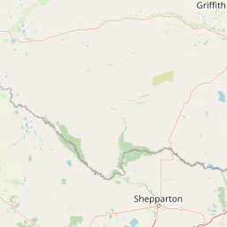
Map view of Warby-Ovens National Park

Use this park location map to pinpoint Warby-Ovens National Park in Australia, understand its exact geographic position, and read its mapped placement within the surrounding landscape more clearly.

Pigeon | © OpenStreetMap contributors
Park atlas

Browse national parks and protected areas, tracing connected landscapes across northeastern Victoria.

Explore Nearby National Parks and Protected Areas Near Warby-Ovens National Park
After exploring Warby-Ovens National Park's Box-Ironbark forests and granite-influenced terrain, continue your discovery by browsing other protected areas and national parks throughout northeastern Victoria. Comparing these diverse landscapes offers richer insights into regional conservation efforts, shared ecological features, and the spread of significant woodland bird habitats across Australia's Victorian state.
National park

Mount Buffalo National Park: Historic Granite Plateau in Victoria's Alpine Region

Mapped Protected Landscape and Geographic Context

Mount Buffalo National Park represents a significant protected area within Victoria, Australia, celebrated for its distinctive granite plateau. This national park, one of Australia's oldest, features dramatic rock formations, tors, and the iconic summit of The Horn, offering panoramic vistas across the alpine landscape. Its elevation of approximately 1,723 meters supports a variety of ecosystems, from forested slopes to alpine grasslands. The park's unique geology and its role as a protected landscape make it a key destination for understanding regional Australian geography and conservation history.

Area
310 km²
Established
1898
IUCN
II
Visitors
200K annual
National park

Lower Goulburn National Park: Australia's River Red Gum Woodland Protected Landscape

Explore mapped boundaries and riparian geography.

Lower Goulburn National Park in Victoria, Australia, safeguards a critical segment of the Goulburn River, celebrated for its magnificent river red gum woodlands. This protected area offers a linear exploration of a rare riparian ecosystem, providing essential habitat and scenic beauty. Understand its geographic layout, mapped extent, and the distinctive landscape formed by these iconic Australian trees, offering a vital natural contrast to the surrounding agricultural areas.

Area
93.1 km²
Established
2010
IUCN
II
Relief
Lowland
Watercolor illustration showing a lake surrounded by green hills and vegetation
National park

Lake Eildon National Park: Protected Landscape with Ancient Volcanic and Gold Mining Heritage

Explore mapped terrain and diverse eucalypt forests.

Lake Eildon National Park in Victoria's Central Highlands offers a unique protected landscape shaped by ancient volcanic activity and the region's gold rush era. This national park, centered around the large Lake Eildon reservoir, provides critical habitat within its diverse eucalypt forests. Discover its geological significance, historical mining sites, and mapped boundaries, offering a comprehensive view of its protected-area identity and regional geographic context.

Area
277.5 km²
Established
1997
IUCN
II
Relief
Mountain
National parkNew South Wales

Benambra National Park: New South Wales Protected Area and Great Yambla Range Map

Explore mapped terrain and woodland ecosystems.

Benambra National Park serves as a key protected area in New South Wales, preserving crucial white box and Red Box woodland communities against a backdrop of the Great Yambla Range's dramatic topography. This national park is significant for its role in conserving habitat for at least twelve threatened bird species and its unique geological features, including cliff faces and flat-topped peaks. Understanding the park's mapped boundaries and its place within the South West Slopes region offers valuable context for geographic discovery and the study of Australia's natural landscapes.

Area
13.99 km²
Established
2001
IUCN
II
Relief
Mixed relief
Watercolor illustration of a river landscape with green hills, trees, and pink reeds
National park

Barmah National Park National Park: World's Largest River Red Gum Forest Landscape

Explore Mapped Boundaries and Wetland Geography

Barmah National Park in Victoria, Australia, is renowned for protecting the largest river red gum floodplain forest on Earth, a globally significant Ramsar-listed wetland. This protected area's landscape is defined by majestic eucalypts bordering freshwater marshes along the Murray River. Dive into its distinct geography, mapped terrain, and the protected status of this remarkable ecosystem, offering unparalleled opportunities for understanding regional natural landscapes and conservation.

Area
285.21 km²
Established
2010
IUCN
II
Relief
Lowland
National park

Alpine National Park: Victoria's Expansive National Park in the Great Dividing Range

Mapping significant alpine, subalpine, and mountain wilderness landscapes.

Alpine National Park represents Victoria's largest protected area, safeguarding critical alpine and subalpine environments across the Great Dividing Range. This national park encompasses vast mountainous terrain, including Victoria's highest peaks like Mount Bogong, and the expansive Bogong High Plains known for their unique grassland and woodland ecosystems. The park's protected landscape offers rich opportunities for geographic discovery and understanding its place within Australia's significant mountain wilderness regions.

Area
6,474 km²
Established
1989
IUCN
II
Relief
Mountain
National parkNew South Wales

Woomargama National Park: National Park Protected Area with Mapped Landscape Identity

Discover the geographic context and park boundaries.

Woomargama National Park serves as a distinct entity for geographic exploration within New South Wales. As a designated national park, its protected landscape identity is integral to understanding the regional map. This profile facilitates detailed study of its position, natural terrain context, and role within Australia's network of conservation areas, providing structured data for atlas-based discovery.

Area
241.85 km²
Established
2001
IUCN
II
Relief
Upland
Watercolor painting of green trees, rolling hills, and a pastel sky.
National park

Heathcote-Graytown National Park: Protected Box-Ironbark Forests and Swift Parrot Habitat

Mapping the landscape and geography of this Australian National Park.

Heathcote-Graytown National Park is a significant protected area safeguarding one of Victoria's remaining box-ironbark forest ecosystems. Its landscape, nestled within the Great Dividing Range, provides essential habitat for migratory swift parrots and supports diverse woodland bird species recognized by BirdLife International. Explore the park's mapped terrain and understand its role within the Central Highlands' regional geography as a vital conservation landscape.

Area
128.33 km²
Established
2002
IUCN
II
Relief
Mountain

Common questions about visiting, size, designation, and location context for Warby-Ovens National Park

Warby-Ovens National Park FAQs for park facts, access, geography, and protected area context
Find quick answers about Warby-Ovens National Park, including protected-area facts, park geography, trail and visitor context, and how the park fits into its surrounding country and regional landscape.
MoriAtlas Explorer

Continue Your Protected Areas Search Across the Global Atlas

Deepen your exploration by continuing the structured search for national parks and protected areas worldwide. Utilize the comprehensive filtering capabilities to compare different conservation landscapes and refine your understanding of global park geography. Discover more about the distribution and characteristics of protected natural areas.

Global natural geography
Warby-Ovens National Park: Protected Area, Map & Geography | MoriAtlas