
Lakes
Park geography
Structured data covering alpine terrain, water features, and regional boundaries
Geographic Profile and Mapped Boundaries of Waterton Lakes National Park in Alberta
Analyze the physical geography of Waterton Lakes National Park, spanning 505 square kilometers within Alberta. This profile outlines elevation extremes from 1290 meters to 2910 meters and catalogs internal landscape features including the Wilson Range, prominent mountain peaks, and major waterfalls.
Related tags
Rocky MountainsTransboundary protected areaWorld Heritage SiteBiosphere reserveMountain-prairie transition
Where the Rocky Mountains meet theprairies
Waterton Lakes National Park
Waterton Lakes National Park occupies the southwestern corner of Alberta, Canada, where the Rocky Mountains give way to the Canadian Prairies. Established in 1895 as the fourth Canadian national park, it was originally designated as the Kootenay Lakes Forest Reserve before taking its present name, which honors Waterton Lake and the Victorian naturalist Charles Waterton. The park spans approximately 505 square kilometers of rugged mountain terrain and wilderness, featuring a remarkable transition zone where prairie grasslands meet alpine environments. This unique positioning, alongside the park's rich geological history and diverse ecosystems, has earned it international recognition as part of the Waterton-Glacier International Peace Park, a UNESCO World Heritage Site designated in 1995. The park is also notable as Canada’s second biosphere reserve, established under the UNESCO Man and the Biosphere Programme in 1979, reflecting its significance as a living laboratory for understanding human-environment relationships.
- Location
- Canada
- Park type
- National park
- Established
- 1895
- Area
- 505 km²
- Highest point
- 2,910 m
Location overview
Regional positioning in Alberta and transboundary conservation status
Waterton Lakes National Park Geographic Location and Settings
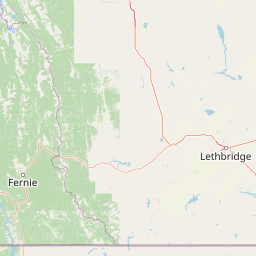
Waterton Lakes National Park is situated within the administrative region of Alberta in Canada. Geographic records confirm its regional placement alongside a documented transboundary status with neighboring protected areas.
- Countries
- Canada
- Regions
- Alberta
- Primary location
- Alberta
- Geographic setting
- Transboundary · Inland
Boundary and coordinates
Interactive boundary geometry and calculated area metrics
Waterton Lakes National Park Boundary Map and Spatial Extent
Mapped park geometry provides immediate spatial context for the protected area. Accompanying boundary facts detail total surface area and coordinate spans without survey-level precision.
- Boundary area
- 499.4 km²
- Boundary perimeter
- 144.2 km
- Northernmost point
- 49.2048° N
- Southernmost point
- 48.9975° N
- Easternmost point
- 113.6534° W
- Westernmost point
- 114.1667° W
- Geographic centre
- 49.0813° N, 113.9332° W
- North–south span
- 23.1 km
- East–west span
- 37.5 km
Elevation and terrain
Vertical range profile and recorded natural features
Waterton Lakes National Park Elevation and Terrain Geography
Recorded elevation spans from 1290 meters to a high point of 2910 meters across mountain terrain. Linked feature cards provide names, types, measurements, and spatial relationships.
- Minimum elevation
- 1,290 m
- Maximum elevation
- 2,910 m
- Highest point
- 2,910 m
Selected named natural features
Streams
North Fork Belly River
Peaks
Mount Dungarvan
2,575 m
Peaks
Vimy Ridge
2,423 m
Lakes
Upper Waterton Lake
Peaks
Bertha Peak
2,454 m
Environmental setting
Temperate climate zones, mountain relief, and major forest cover classifications
Waterton Lakes National Park Environmental Classifications and Physical Settings
Recorded landscape features and habitat types frame the physical setting through complementary interpretive categories. Stored classifications connect recorded terrain properties to relevant atlas destinations.
- Relief
- Mountain
- Climate
- Temperate
- Water
- Major water bodies
- Forest cover
- Mostly forested
- Seasonality
- Year-round
Landscape features
Mountains · Valleys · Forest · Lakes · Rivers · Waterfalls · Cliffs · Beach
Habitat types
Temperate broadleaf forest · Temperate coniferous forest · Grassland · Alpine meadow · Wetland
Park atlas
Browse the regional spread of mountain-prairie transition zones, glacial features, and transboundary conservation landscapes.
Compare Protected Areas: Discover National Parks and Landscapes Near Waterton Lakes National Park
Explore a curated list of national parks and protected areas geographically connected to Waterton Lakes National Park, spanning diverse Rocky Mountain and prairie ecosystems. Compare unique landscapes, geological features like the Lewis Overthrust, and significant conservation efforts across this distinct North American region.
National parkMontana
Park boundaries overlap#1 closest
South

Glacier National Park: A Montana National Park with Distinct Protected Landscape Geography
Explore its mapped boundaries and regional natural terrain.
Glacier National Park represents a significant national park entity within Montana, providing a unique lens for understanding protected landscapes and regional geography. As a key component of the US protected areas network, it offers valuable insights into mapped park boundaries and the surrounding natural terrain. This page serves as a gateway to exploring the specific geographic context and landscape identity of Glacier National Park.
- Area
- 4,100.77 km²
- Established
- 1910
- IUCN
- II
- Visitors
- 2.9M annual
Protected landscapeMontana
41 km away#2 closest
Southwest
Kootenai National Forest: Geography and Protected Land Map for Northwestern Montana
Northern Rockies mountain ranges and watershed analysis.
Spanning over two million acres, Kootenai National Forest represents a critical protected landscape in the Northern Rockies. This atlas entry details the interplay between the Cabinet Mountains, regional river systems like the Kootenai and Clark Fork, and the dense conifer forests that define this uniquely wet corner of Montana.
- Area
- 8,900 km²
- Established
- 1907
- Relief
- Mountain
- Climate
- Temperate

Protected landscapeMontana
72 km away#3 closest
Southeast
Helena-Lewis and Clark National Forest: Geographic Overview and Protected Area Map
Montana wilderness spanning the Continental Divide
Spanning from the rolling eastern plains to the crest of the Northern Rockies, Helena-Lewis and Clark National Forest serves as a massive protected landscape in central Montana. This forest system protects eight unique mountain ranges and critical wilderness corridors, offering a comprehensive look at the ecological transition zones of the American Mountain West.
- Area
- 11,000 km²
- Established
- 1897
- Relief
- Mountain
- Climate
- Temperate
Protected areaMontana
125 km away#4 closest
South
Lolo National Forest: An Atlas of Protected Lands and Mountainous Terrain in Montana
Ecological transition zone of the northern Rocky Mountains
This protected area covers two million acres of diverse northern Rocky Mountain geography. Known for its massive western red cedars and transitional ecology, the forest features a complex network of ridgelines, glacial lake basins, and river corridors that serve as vital habitat across the Montana landscape.
- Area
- 8,894.85 km²
- Established
- 1906
- Relief
- Mountain
- Climate
- Temperate
Wildlife reserveMontana
144 km away#5 closest
South
Mission Mountains Wilderness: A Rugged Protected Area in the Montana Rocky Mountains
Glacial topography and high elevation alpine ecosystems
Mission Mountains Wilderness is a defining landmark in northwestern Montana, characterized by a steep and narrow mountain spine that rises abruptly above the Flathead Valley. The area protects a full spectrum of ecosystems, from dense coniferous forests to exposed talus slopes and alpine tundra. With its glacially carved cirques and deep U shaped valleys, this wilderness functions as a key component of a larger, jointly managed regional conservation landscape in the United States.
- Area
- 298.97 km²
- Established
- 1975
- IUCN
- Ib
- Relief
- Mountain
National parkCanada
193 km away#6 closest
Northwest

Banff National Park: Exploring Canada's Iconic National Park Protected Landscape and Geography
Mapped park boundaries and regional geographic context for Banff National Park.
Gain a structured understanding of Banff National Park as a key protected area within Canada. This resource details its identity as a national park, providing insights into its geographic setting and mapped landscape. It serves as a vital point for atlas-based discovery, helping to contextualize Banff National Park's significance within Canada's protected lands and natural terrain.
- Area
- 6,641 km²
- Established
- 1885
- IUCN
- II
- Visitors
- 4.1M annual
National parkBritish Columbia
201 km away#7 closest
Northwest
Kootenay National Park: National Park Protected Landscape and Geographic Context
Explore Kootenay National Park's mapped terrain and regional geography.
Kootenay National Park is a protected national park located in British Columbia, Canada. This dedicated detail page provides an atlas-style exploration of its geographic identity, focusing on its mapped boundaries and the surrounding natural terrain. Understand how Kootenay National Park fits into the larger regional geography, offering rich context for protected landscape discovery and analysis.
- Area
- 1,406 km²
- Established
- 1920
- IUCN
- II
- Visitors
- 574.1K annual
Wildlife reserveAlberta
About 203 km away#8 closest
North
Inglewood Migratory Bird Sanctuary: Federal Wildlife Reserve and Riparian Corridor Map
Protected riparian ecosystems along the Bow River in Alberta.
Analyze the geography of the Inglewood Migratory Bird Sanctuary, a federal wildlife reserve in Calgary, Alberta. This site preserves rare cottonwood floodplain forest and river habitats that serve as a critical stopover for migratory birds, offering a unique look at how protected landscapes persist within urban environments.
- Area
- 1.11 km²
- Established
- 1929
- Relief
- Lowland
- Scope
- Terrestrial
MoriAtlas Explorer
Continue Exploring Waterton Lakes National Park's Geographic and Landscape Context
Delve deeper into the structured geographic information for Waterton Lakes National Park. Understand its protected landscape identity, mapped terrain, and its unique position within Alberta's vast regional geography. This detailed exploration supports a comprehensive understanding of the park's atlas significance and its place within Canada's network of protected areas.
Browse next
Global natural geography
Explore related park routes
Explore MoriAtlas Global ParksBrowse All MoriAtlas ParksGlobal Park Map DiscoveryMoriAtlas: Browse All CountriesBrowse All MoriAtlas ContinentsNational Park Environment AtlasGrand Canyon National Park AtlasYellowstone National Park AtlasYosemite National Park Atlas and GeographySerengeti National Park AtlasGalápagos National Park Protected LandscapeBanff National Park Geography and AtlasKruger National Park Atlas EntryUluṟu-Kata Tjuṯa National Park AtlasExplore Uluru-Kata Tjuta National Park GeographyPlitvice Lakes National Park AtlasFiordland National Park Protected LandscapeGreat Smoky Mountains National Park AtlasAfghanistan National Parks and Protected AreasAlbania National Parks and Protected AreasAlgeria National Parks and Protected AreasAmerican Samoa National Parks and Protected AreasAndorra National Parks and Protected AreasAngola National Parks and Protected AreasAntarctica National Parks and Protected AreasAntigua and Barbuda Park List