Mori Atlas logo
Protected landscapeWayne National Forest

A rugged forest mosaic spanning the unglaciated Allegheny Plateau and its unique geological features.

Wayne National Forest: Exploring the Protected Appalachian Landscapes of Southeastern Ohio

Wayne National Forest stands as the only national forest in Ohio, protecting a vast expanse of Appalachian terrain across three distinct units. The landscape is defined by the deeply dissected Unglaciated Allegheny Plateau, where sandstone and shale geology form steep ridges and entrenched hollows. This protected area showcases a significant history of ecological recovery, featuring expansive hardwood communities and essential migratory songbird habitats that trace the natural history of the region.

Appalachian landscapenational forestOhioreforestation landmixed hardwood forestrugged terrain

Wayne National Forest

Protected landscape

Park overview

Structured park overview, official facts, and landscape profile for Wayne National Forest

Wayne National Forest park facts, protected area profile, and essential visitor context

Review the core facts for Wayne National Forest, including designation, size, terrain, visitor scale, habitats, and operating context in one park-focused overview.

About Wayne National Forest

Wayne National Forest covers more than 240,000 acres of forested land in southeastern Ohio, with a proclamation boundary that extends over a much larger area across multiple counties. It is the only unit of the U.S. National Forest System located entirely within Ohio, and its character is strongly shaped by the Appalachian topography, the legacy of 19th-century land use, and the recovery of forest cover during the 20th century.

The forest sits on the Unglaciated Allegheny Plateau, a region whose geology differs from glaciated portions of the Midwest. The substrate includes late Paleozoic sandstone and shale, iron-stained redbeds, and numerous coal beds. Exposed to prolonged weathering after wide-scale clearing, the land developed substantial erosion. The national forest is essentially a 20th-century reforestation landscape, today grown into a network of hardwood ridges, sheltered hollows, and cliff-lined streams.

Wayne National Forest is managed in three units, each named for a regional center: Athens, Marietta, and Ironton. The Athens and Marietta Units form the Athens Ranger District, while the Ironton Unit forms a separate district. Recreation areas, trail systems, and ATV routes are distributed across all three, and the forest is crossed by several national recreation trails. Its administrative headquarters overlook the Hocking River, between The Plains and Nelsonville, on US Route 33.

Despite its name, Wayne is not a contiguous block of wilderness. Many parts were logged or mined before they were acquired, and federal ownership often excludes the mineral estate, meaning the forest exists as a patchwork of public land surrounded by private holdings. This mix of past use, ongoing reclamation, and recovery is central to Wayne's identity.

Quick facts and research context for Wayne National Forest

Wayne National Forest lies entirely within Appalachian Ohio and is the sole official national forest in that state. Its terrain sits on late Paleozoic sandstone and shale geology, producing the rugged topography and deep ravines that define much of the forest. It was administratively separated from the Hoosier National Forest and reconstituted as an independent national forest in December 1992.

The forest is divided into three units based around Athens, Marietta, and Ironton, and much of the included land is former coal-mining country held by federal ownership with mineral rights retained by previous holders. Wayne is crossed by several notable long-distance trails and is connected to the broader recreation network of southeastern Ohio.

Protection and recognition

Comprehensive review of terrestrial protection measures and official designation records for Wayne National Forest.

Wayne National Forest Protection Status and Designated Terrestrial Conservation Scope

Wayne National Forest maintains a documented terrestrial protection scope detailing its environmental management framework and administrative boundaries. Structured conservation records outline official designation history, geographic parameters, and international recognition metrics.

Protection details

Protection scope
Terrestrial
Transboundary protection
No
Park context

Deeper park guide and search-rich context for Wayne National Forest

Wayne National Forest history, landscape, wildlife, and travel context

Explore Wayne National Forest through its history, landscape character, ecosystems, wildlife, conservation priorities, cultural context, and seasonal travel timing in a structured park guide built for atlas discovery and search intent.

Why Wayne National Forest stands out

Wayne National Forest is best known for being Ohio's only national forest and for showcasing the rugged Appalachian character of the state's southeastern region. It is recognized for its deeply dissected landscape, with forested ridges, hollows, and ravines shaped by sandstone and shale. The forest is also widely noted for its mixed mesophytic hardwood communities, including oak, hickory, tulip tree, sugar maple, and American beech, along with cool ravines that shelter eastern hemlock and white pine. The combination of recovering second-growth forest, reclaimed mine land, and a rich spring wildflower display gives Wayne a distinct ecological identity within the broader Appalachian forest system.
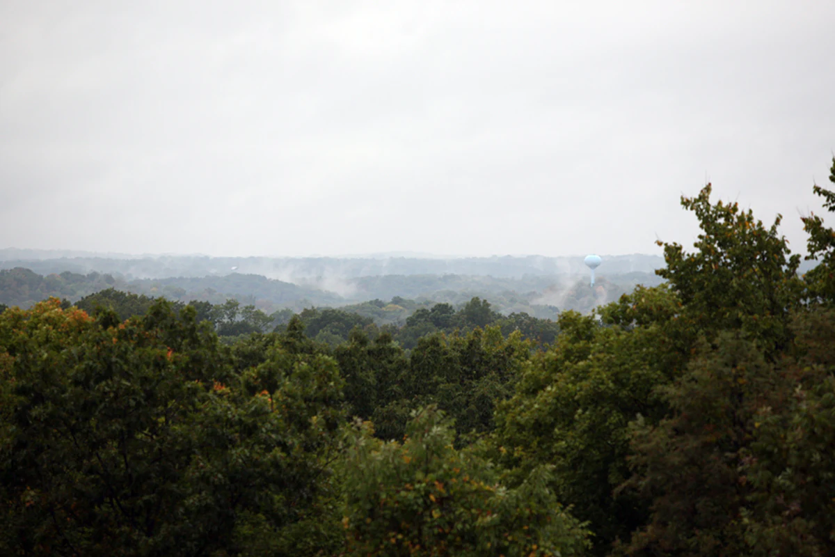
A wide, hazy landscape view looking over a sprawling green forest under an overcast sky.
A view overlooking the dense hardwood forest canopy of Wayne National Forest in Ohio.

Wayne National Forest history and protected-area timeline

The land now covered by Wayne National Forest was ceded to the United States by the Northwestern Confederacy in 1795 through the Treaty of Greenville, which opened much of present-day Ohio to American settlement. Throughout the late 18th and 19th centuries, the region's forests were cleared for farming and timber, and poor practices led to severe erosion and thin soils.

In response to that widespread degradation, the U.S. government undertook reforestation efforts, and the first federal land acquisitions for what would become Wayne National Forest were made in 1935. Initially, the forest was administered together with the Hoosier National Forest under the consolidated Wayne-Hoosier National Forest, with headquarters in Indiana. This arrangement lasted until December 1992, when Wayne was established as an independent national forest with its own administration in southeastern Ohio. The forest was first informally referred to as the Ohio National Forest and later officially named Wayne National Forest in honor of General Anthony Wayne, a Revolutionary War-era military figure and statesman often associated with Ohio's early history.

More recent history includes controversy. In 2022, a fire official deliberately set fires that burned roughly 1,300 acres of the forest; the individual was sentenced in 2025 to prison time and restitution. In 2024, the federal government proposed allowing oil and gas fracking across roughly 40,000 acres of Wayne, drawing opposition from conservation groups and reviving a legal debate from 2020.

The forest has also been the subject of a proposed renaming. In August 2023, the U.S. Forest Service proposed renaming Wayne National Forest as Buckeye National Forest, citing concerns over its namesake's historical significance. Alternatives raised in comments included Ohio National Forest, Pawpaw National Forest, and the Shawnee-origin name Koteewa National Forest. As of the available record, no renaming had been formally adopted.

Wayne National Forest landscape and geographic character

Wayne National Forest lies across the Unglaciated Allegheny Plateau in southeastern Ohio. Its terrain reflects the work of erosion on sedimentary rock, producing steep ridges separated by narrow hollows and entrenched streams rather than rounded glacial features. Elevation differences across the forest commonly run into the hundreds of feet, giving the land a far more rugged profile than much of the surrounding Midwest.

The geology is dominated by late Paleozoic sandstones and shales, including bands of distinctive iron-rich redbeds. Coal seams are also a notable feature of the substrate, and many of the lands within the forest are former coal-mining areas that have since been reclaimed. This combination of rocky terrain, weathered soils, and reclamation history shapes much of the forest's character today.

The forest is divided into three units scattered across southeastern Ohio rather than forming a single solid block. The Athens Unit covers parts of Athens, Hocking, Morgan, Perry, and Vinton Counties; the Marietta Unit spans Monroe, Noble, and Washington Counties, with the majority of its acreage in Washington County; and the Ironton Unit extends through Gallia, Jackson, Lawrence, and Scioto Counties, with most of its area in Lawrence County.

Wayne National Forest ecosystems, habitats, and plant life

The forests of Wayne are dominated by mixed mesophytic hardwood communities typical of the central Appalachians. Overstory species include oak, hickory, red maple, sugar maple, American beech, tulip tree, black cherry, and ash, while eastern hemlock and white pine cling to cooler ravines and shaded stream corridors. On drier, disturbed, or reclaimed upland sites, shortleaf pine and Virginia pine are more common, and the understory of these forests brings in pawpaw, spicebush, flowering dogwood, eastern redbud, and serviceberry.

Distinct microclimates play a major role in Wayne's ecological identity. Cold-air drainage along streams supports moisture-loving species, while exposed ridgetops and reclaimed ground favor drought-tolerant and early-successional vegetation. The combination of mature forest, recovering mine land, and ravine microhabitats gives the forest multiple vegetation communities within relatively short distances.

Spring is a particularly notable season ecologically, as the forest floor hosts an abundance of native wildflowers. Trillium, mayapple, bloodroot, spring beauty, and several species of violets create a rich seasonal display. Across the broader year, the forest supports extensive riparian and wetland habitat around its many small streams.

The wildlife setting of Wayne is broadly Appalachian rather than Midwestern. Mammal communities include white-tailed deer, eastern gray squirrels, fox squirrels, raccoons, opossums, striped skunks, coyotes, red foxes, and bobcats. Smaller mammals such as chipmunks, voles, bats, and shrews occupy the understory and forest floor. The forest hosts breeding populations of neotropical migratory songbirds, including wood thrush, scarlet tanager, cerulean warbler, and ovenbird, alongside barred owl, wild turkey, and a variety of woodpeckers and hawks. Bald eagles and osprey have also become more frequently observed near larger rivers and reservoirs.

Reptile and amphibian life thrives around the forest's extensive stream network and wetlands. Eastern box turtles, timber rattlesnakes, black rat snakes, and northern water snakes occur across the forest, while amphibians include American toad, spring peeper, and several salamander species, among them red-backed and spotted salamanders.

Wayne National Forest wildlife and species highlights

Wildlife observation is a quiet but important dimension of Wayne National Forest. Mammals are typical of the central Appalachians: white-tailed deer are widespread, and the forest supports healthy populations of eastern gray and fox squirrels, raccoon, opossum, striped skunk, coyote, red fox, and bobcat. Smaller mammals, including chipmunks, voles, bats, and shrews, are also part of the everyday ecological community.

The forest is particularly significant for birds. Its interior woodlands serve as breeding habitat for a number of neotropical migratory songbirds, including wood thrush, scarlet tanager, cerulean warbler, and ovenbird. Resident species such as barred owl and wild turkey are joined by various species of woodpeckers and hawks, and both bald eagles and osprey have been increasingly observed near rivers and larger reservoirs.

Reptile and amphibian life is tied closely to the forest's cold streams and moist hollows. Eastern box turtle, timber rattlesnake, black rat snake, and northern water snake are among the reptiles present, while amphibians include American toad, spring peeper, and several species of salamander such as the red-backed and spotted salamanders. This combination of interior-forest birds and moisture-loving herpetofauna gives Wayne an Appalachian rather than Midwestern wildlife profile.

Wayne National Forest conservation status and protection priorities

Wayne National Forest has its origins in a federal effort to restore land that had been damaged by 19th-century clearing, and that conservation background remains central to its identity. The forest was assembled beginning in 1935 as a reforestation response to widespread soil loss, and today stands as an example of successful second-growth forest recovery on former farmland and mine land.

Modern conservation discussions around Wayne include the ongoing tension between its protected status and the commercial use of underlying mineral rights owed to former mining operators. Conservation groups have also actively challenged federal proposals to open portions of the forest to oil and gas fracking, including a 2024 proposal that would have affected roughly 40,000 acres.

In a different kind of conservation story, in May 2024 the forest planted a sweetgum Moon Tree, a sapling grown from seeds that flew aboard NASA's Artemis I mission. The initiative, a partnership between NASA and the U.S. Forest Service, reserves the tree as part of a broader project to preserve biological material that has traveled beyond low Earth orbit.

Wayne National Forest cultural meaning and human context

Wayne National Forest lies in a region whose cultural geography is closely tied to Appalachian Ohio. Southeastern Ohio has long been associated with coal mining, small rural communities, and a landscape that was once heavily farmed and timbered. Names within the forest, like the proposed Buckeye or Pawpaw alternatives, reflect local identity and native plant life, while the shortlist of names once considered by the U.S. Forest Service also included Koteewa, a Shawnee-language word referring to the buckeye.

The forest's namesake, Anthony Wayne, is a complex historical figure revered in some parts of Ohio for his role in early American military campaigns but also contested by others for the violence associated with westward expansion and indigenous displacement. Efforts to consider renaming the forest, organized in part by American Indian tribes, reflect that this part of Ohio continues to negotiate how its public landscapes commemorate American history.

Top sights and standout views in Wayne National Forest

Wayne National Forest's strongest points of identity are its role as Ohio's only national forest, its rugged Appalachian terrain shaped by sandstone and shale, and its recovery story as a 20th-century reforestation landscape. The mixed mesophytic hardwood communities and spring wildflower displays give it a recognizable Appalachian ecological character.

The forest also stands out for its long-distance trail connections, including shared alignments of the North Country Trail, the Buckeye Trail, and the American Discovery Trail. Its three-unit organization across Athens, Marietta, and Ironton, alongside ongoing debates about fossil fuel leasing and renaming, keep Wayne at the center of contemporary discussions about how Appalachian forests are protected and named.

Best time to visit Wayne National Forest

Spring and fall are generally the most rewarding seasons for visiting Wayne National Forest. In spring, the forest floor erupts with trillium, mayapple, bloodroot, spring beauty, and a range of violets, and the cooler air along shaded ravines keeps many of the area's most interesting plant communities active. The same seasons offer mild temperatures and colorful hardwood foliage.

Summer can bring heat and humidity, but is the most reliable period for certain wildlife observation, and for accessing recreation areas, trailheads, and water-based recreation. Winter is generally the quietest season, with cool, bare-canopy conditions that can make ridge and ravine topography especially easy to read on foot, though weather and access constraints vary across the three units.

In every season, choosing one of the forest's three units, Athens, Marietta, or Ironton, and using its individual trail systems will shape the kind of experience a visitor has.

Monthly climate preview

Long-term monthly averages of temperature and precipitation for Ohio

Wayne National Forest Climate Normals and Annual Temperature Patterns

Representative baseline measurements reveal the multi-year temperature progression and precipitation rhythm across twelve recorded intervals at Wayne National Forest. Examining the complete monthly climate dataset provides deeper insight into measured extremes and long-term environmental patterns.
Annual mean12 °C
-2 °C24 °C
Jan-2°
Feb
Mar
Apr11°
May17°
Jun22°
Jul24°
Aug24°
Sep20°
Oct13°
Nov
Dec
Warmest month
July

24.2 °C

Coolest month
January

-1.7 °C

Wettest month
June

3.5 mm/day

Driest month
October

2.4 mm/day

Park location guide

Geography guide, regional context, and park location map for Wayne National Forest

Wayne National Forest park geography, regions, and map view in United States of America

Understand where Wayne National Forest sits in United States of America through a broader geographic reading of the surrounding landscape, nearby location context, and its mapped position within the national park landscape.

How Wayne National Forest fits into United States of America

The United States of America is a federal presidential republic and one of the world's largest countries by area and population. It consists of 50 states across a vast territory spanning multiple time zones, with its capital in Washington, D.C. and largest city in New York City. The nation has a diverse economy, influential political system, and significant cultural and military presence globally.

Wider geography shaping Wayne National Forest in United States of America

The United States occupies a vast territory in North America, bordered by Canada to the north and Mexico to the south. The 48 contiguous states stretch from the Atlantic to the Pacific Ocean, while Alaska occupies the northwestern region and Hawaii is an archipelago in the Pacific. The country encompasses diverse terrain including the Rocky Mountains, Appalachian Mountains, Great Plains, and extensive river systems.

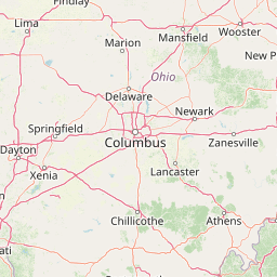
Map view of Wayne National Forest

Use this park location map to pinpoint Wayne National Forest in United States of America, understand its exact geographic position, and read its mapped placement within the surrounding landscape more clearly.

Pigeon | © OpenStreetMap contributors

Location context for Wayne National Forest

Ohio

Visual reference guide to Appalachian ridges, mixed hardwood forests, and protected terrain.

Wayne National Forest Photos and Landscape Scenery

Visual records capture the rugged topography and mixed mesophytic hardwood communities spanning the Unglaciated Allegheny Plateau. Photographic documentation reveals the distinct sandstone geology, steep hollows, and recovering reforestation environment defining Ohio's protected forest.

A wide, hazy landscape view looking over a sprawling green forest under an overcast sky.

Park atlas

Compare regional geography, connected trails, and nearby protected natural areas.

Other Parks Near Wayne National Forest and Surrounding Protected Landscapes

Browsing other parks near Wayne National Forest reveals the diverse forested terrain and rugged plateau topography spanning the surrounding region. Extending the geographic comparison helps trace broader Appalachian conservation patterns and connected natural landscapes across the state.
National parkWest Virginia
About 171 km away#1 closest

Southeast

New River Gorge National Park and Preserve: Appalachian River Gorge Protected Landscape Atlas

Mapped terrain and geographic context within West Virginia.

Delve into the protected landscape identity of New River Gorge National Park and Preserve, a significant national park in West Virginia. This page details its role as a protected area, highlighting the dramatic river gorge geography, mapped terrain, and its place within the Appalachian Mountains. Understand the park's boundaries and the natural context that makes it a key destination for geographic discovery and conservation appreciation.

Area
294.64 km²
Established
2020
IUCN
V
Visitors
1.6M annual
Protected landscapeWest Virginia
About 172 km away#2 closest

Southeast

Gauley River National Recreation Area: Appalachian Gorge and Protected River Landscape

Mapped terrain, remote forest corridors, and river-centered geography in West Virginia.

Gauley River National Recreation Area protects a rugged corridor defined by high-volume river channels, sheer rock outcrops, and dense Appalachian hardwood forests. This documentation covers the park's distinct river-centered geography, the interplay of tributary hollows with main river flows, and its status as a critical piece of the broader southern West Virginia mountain landscape.

Area
46.57 km²
Established
1988
IUCN
V
Visitors
213.6K annual
Watercolor painting showing layers of soft green hills and mountain ridges fading into a light hazy background.
Protected landscapeWest Virginia
About 177 km away#3 closest

East

Monongahela National Forest: Protected Appalachian Landscapes and Regional Geography

Mapping West Virginia wilderness and mountain terrain

Monongahela National Forest protects nearly one million acres of the central Appalachian Mountains. This massive federally managed landscape is defined by the Allegheny Front, the highest peak in the Allegheny range at Spruce Knob, and iconic geological formations like Seneca Rocks. The region represents a vital intersection of climate, hydrology, and biodiversity in the eastern United States, housing eight distinct wilderness areas and complex high-altitude ecosystems.

Area
3,727.8 km²
Established
1920
Visitors
3M annual
Relief
Mountain
National parkOhio
About 181 km away#4 closest

North

Cuyahoga Valley National Park: Detailed Atlas and Protected Landscape Information

Explore the mapped geography and natural terrain of Ohio's National Park.

Access detailed atlas information for Cuyahoga Valley National Park, a vital protected landscape in Ohio. Understand its geographic scope, mapped boundaries, and the surrounding natural terrain. This entry provides essential context for exploring the park's identity as a National Park and its significance within the broader mapped geography of the United States.

Area
132.7 km²
Established
2000
IUCN
II
Visitors
2.9M annual
A soft watercolor painting depicting a marshy landscape with trees, grasses, and a body of water in a pale, airy style.
Nature reserveOhio
About 213 km away#5 closest

North

Old Woman Creek National Estuarine Research Reserve: Protected Lake Erie Estuary

Northern Ohio coastal wetland and research landscape.

Old Woman Creek National Estuarine Research Reserve represents a vital freshwater estuary on the Lake Erie shore. This reserve protects a unique combination of marsh, swamp forest, and barrier beach, providing significant insight into the natural function of Great Lakes coastal systems in northern Ohio.

Area
2.32 km²
Established
1980
Relief
Lowland
Climate
Temperate
A wide, panoramic watercolor illustration showing a row of green trees, faint mountains in the background, and grass reeds in the foreground left against a white background.
Wildlife reserveWest Virginia
About 215 km away#6 closest

Southeast

Laurel Fork South Wilderness: Protected Appalachian Highlands and Forested Terrain

High elevation forest and creek drainage geography

Laurel Fork South Wilderness features a dense, unbroken stretch of Appalachian forest within West Virginia. This protected landscape is defined by its deep narrow hollows and high ridgelines, representing a vital example of mid elevation mountain terrain and recovering forest ecosystems within the Monongahela National Forest.

Area
23.41 km²
Established
1983
IUCN
Ib
Relief
Mountain
Wildlife reserveWest Virginia
About 216 km away#7 closest

East

Laurel Fork North Wilderness: Mapping Appalachian Forest and Mountain Terrain

Protected wilderness landscape in the West Virginia highlands.

Laurel Fork North Wilderness sits as a key conservation unit within the Monongahela National Forest. This protected territory preserves a complex of high-elevation hardwood forests and the stream-cut valley of Laurel Fork. By examining this region, users gain insight into the geography of Allegheny mountain wilderness and the persistent character of recovery-focused Appalachian landscapes.

Area
24.5 km²
Established
1983
IUCN
Ib
Relief
Mountain
A pale, abstract watercolor painting showing a wide view of soft, layered green and pink mountains with a few stylized trees in the lower right.
Wildlife reserveWest Virginia
About 228 km away#8 closest

East

Roaring Plains West Wilderness: Geographic Overview and Protected Plateau Mapping

High-altitude wilderness and Appalachian watershed geography

Roaring Plains West Wilderness encompasses one of the largest high-elevation plateaus in the eastern United States. This protected area within West Virginia hosts dramatic rim-rock vistas and extensive sphagnum bogs, standing as a primary ecological feature along the Eastern Continental Divide. Examine the mapped terrain and environmental boundaries of this significant Allegheny Mountain preserve.

Area
27.6 km²
Established
2009
IUCN
Ib
Relief
Highland

Common questions about visiting, size, designation, and location context for Wayne National Forest

Wayne National Forest FAQs for park facts, access, geography, and protected area context

Find quick answers about Wayne National Forest, including protected-area facts, park geography, trail and visitor context, and how the park fits into its surrounding country and regional landscape.
MoriAtlas Explorer

Continue Your Protected Areas Search Across the Global Atlas

Deepen your exploration by continuing the structured search for national parks and protected areas worldwide. Utilize the comprehensive filtering capabilities to compare different conservation landscapes and refine your understanding of global park geography. Discover more about the distribution and characteristics of protected natural areas.

Global natural geography