Mori Atlas logo
Wildlife reserveWeenen Game Reserve

Examining the ecological reclamation and diverse inland thornveld terrain within this KwaZulu-Natal reserve

Weenen Game Reserve: A Case Study in Restored Savanna Geography and Protected Wildlife Landscapes

Weenen Game Reserve occupies a unique position in the geography of inland KwaZulu-Natal as a testament to intensive land reclamation and ecological restoration. Covering 5,000 hectares of savanna, the area showcases a transition from heavily eroded farmland to a thriving mosaic of open grasslands, thornveld thickets, and valley bushveld. Visitors and researchers use these mapped boundaries to study the resilience of South African ecosystems and the role of active conservation in managing rhinoceros habitats and diverse bird populations.

inland KwaZulu-Natalacacia savannagrassland reservethornveldvalley bushveldrhinoceros conservation

Weenen Game Reserve

Wildlife reserve

Park overview

Structured park overview, official facts, and landscape profile for Weenen Game Reserve

Weenen Game Reserve park facts, protected area profile, and essential visitor context

Review the core facts for Weenen Game Reserve, including designation, size, terrain, visitor scale, habitats, and operating context in one park-focused overview.

About Weenen Game Reserve

Weenen Game Reserve sits in the heart of inland KwaZulu-Natal, South Africa, not far from the provincial capital Pietermaritzburg. The reserve covers roughly 5,009 hectares of gently undulating terrain shaped by the Tugela River catchment, where seasonal watercourses, valleys, and low ridges define a landscape that is quintessentially South African savanna.

The reserve is administered by Ezemvelo KZN Wildlife, the provincial conservation authority responsible for protected areas across KwaZulu-Natal. Within this institutional framework, Weenen plays a particular role as a savanna reserve focused on habitat recovery and the display of typical inland wildlife. Its size makes it manageable for educational visits and guided walking experiences, while still supporting viable populations of large mammals.

Weenen is also notable for its ecological versatility. Three main vegetation types, namely Dry Tall Grassveld, Mixed Thornveld, and Valley Bushveld, meet within its borders, producing a patchwork of grassy plains, thornveld, and denser bush. This diversity supports a broad mammal community and a thriving birdlife, with more than 230 bird species recorded. The reserve provides self-catering accommodation, camping and caravan sites, picnic spots, hides at waterholes, and guided 8-kilometre walking trails, making it both a practical conservation site and an accessible wildlife destination.

In essence, Weenen Game Reserve reflects the modern South African model of a small but ecologically meaningful reserve: a landscape rebuilt from degradation, carefully managed through fire and herbivore control, and opened to visitors seeking a less commercialised bushveld experience.

Quick facts and research context for Weenen Game Reserve

Weenen Game Reserve is a 5,009-hectare protected area located in the inland KwaZulu-Natal province of South Africa, near the city of Pietermaritzburg. It is governed by Ezemvelo KZN Wildlife and was formally proclaimed a nature reserve in 1975, after decades of soil and wetland reclamation work transformed heavily degraded farmland into functional savanna habitat.

The reserve protects a mosaic of Dry Tall Grassveld, Mixed Thornveld, and Valley Bushveld vegetation that supports a typical KwaZulu-Natal savanna fauna, including black and white rhinoceros, giraffe, zebra, kudu, and eland. Rangeland management through controlled burning and grazing pressure is a defining feature of the property, and more than 230 bird species have been recorded on site.

Protection and recognition

Documented terrestrial protection scope and conservation designation records

Weenen Game Reserve Protection Status and International Recognition Data

Weenen Game Reserve maintains a documented terrestrial protection scope without imported international recognition sources or transboundary status. Review the structured conservation records to trace the formal designation details and management context associated with the reserve.

Protection details

Protection scope
Terrestrial
Transboundary protection
No
Park context

Deeper park guide and search-rich context for Weenen Game Reserve

Weenen Game Reserve history, landscape, wildlife, and travel context

Explore Weenen Game Reserve through its history, landscape character, ecosystems, wildlife, conservation priorities, cultural context, and seasonal travel timing in a structured park guide built for atlas discovery and search intent.

Why Weenen Game Reserve stands out

Weenen Game Reserve is best known for being a rehabilitated savanna landscape. Its land was once a labour tenant farm suffering severe soil erosion, and the modern reserve exists because of a landmark reclamation effort by the Department of Agriculture before its 1975 proclamation. This restoration story gives the reserve a strong identity as a working example of land recovery in KwaZulu-Natal. It is also recognised for its classic mix of inland KwaZulu-Natal wildlife: both black and white rhinoceros, giraffe, kudu, eland, red hartebeest, and zebra roam grasslands interspersed with thornveld thickets. The reserve combines accessible ecotourism facilities with serious conservation management, including carefully controlled grazing and the deliberate exclusion of erosion-prone grazers like blue wildebeest and warthog at the time of stocking.

Weenen Game Reserve history and protected-area timeline

The history of Weenen Game Reserve begins with land degradation rather than conservation. Before 1948, the area functioned as a labour tenant farm where subsistence crop production and livestock grazing were practised under social and economic conditions that placed severe strain on the land. Inappropriate farming methods led to extensive soil erosion, gully formation, and the deterioration of wetland systems.

In 1948, the South African Department of Agriculture expropriated the farm in order to halt the environmental decline. Rather than simply fencing the land, the department undertook a detailed programme of erosion control and wetland rehabilitation. Workers and engineers constructed retaining walls, gabion structures, rock packs, and brush packs across the worst-affected areas, while grazing was restricted to allow vegetation to recover. These interventions gradually stabilised the soil and re-established hydrological function across the property.

By 1975, two and a half decades of restoration work had transformed the degraded farmland into ecologically functional savanna suitable for wildlife. That year, the area was formally proclaimed a nature reserve, creating what is now Weenen Game Reserve. Under the management of Ezemvelo KZN Wildlife, the reserve has continued to be shaped by deliberate management choices, including the strategic use of fire, the regulation of herbivore numbers, and the original exclusion of grazing species such as blue wildebeest, impala, and warthog because of their known potential to cause further soil erosion.

Weenen Game Reserve landscape and geographic character

The landscape of Weenen Game Reserve is characteristic of inland KwaZulu-Natal: rolling terrain with a mix of open grassy plains, thornveld slopes, and denser valley bush. The reserve sits within the broader Tugela River catchment, and its valleys are shaped by seasonal streams and small drainage lines that once suffered heavy erosion and have since been stabilised through extensive reclamation work.

Dry Tall Grassveld dominates the more open areas, presenting a relatively sparse, sun-exposed grassland dominated by common thatching-type grasses and increasingly encroached by woody species. In contrast, Mixed Thornveld occupies transitional slopes, where thorny acacia trees and a variety of shrubs create thicker cover and richer habitat structure. Valley Bushveld fills the lower-lying areas and valleys, producing denser, bushier vegetation.

Retaining walls, gabions, rock packs, and brush packs are a quiet but persistent feature of the terrain, marking the long-term engineering response to past soil loss. Waterholes, some equipped with hides, also shape the visitor experience and concentrate wildlife viewing in predictable locations. Together, these features give Weenen a landscape that is both ecologically typical of its region and visually distinctive for its blend of restored grasslands and thornveld mosaics.

Weenen Game Reserve ecosystems, habitats, and plant life

Ecologically, Weenen Game Reserve is a textbook example of inland KwaZulu-Natal savanna. Three principal vegetation types meet within its boundaries: Dry Tall Grassveld, Mixed Thornveld, and Valley Bushveld. This combination produces a layered habitat in which open grassy areas contrast with thornveld thickets and bushier valley bottoms, supporting a wide spectrum of grazing and browsing conditions for different species.

The Dry Tall Grassveld is comparatively sparse and dominated by common grass species such as Hyparrhenia hirta, with woody encroachment a recurring management issue. Mixed Thornveld adds structural complexity, with trees and shrubs such as Vachellia karroo, Vachellia nilotica, Euclea crispa, Euclea racemosa, Olea europaea, Ozoroa paniculosa, Premna mooiensis, and Vitex rehmannii contributing to the canopy and understorey. Valley Bushveld completes the mosaic by adding denser vegetation in the lowlands.

Rangeland at Weenen is actively managed rather than left to wilderness processes alone. Fire is used strategically to maintain grass quality and control woody encroachment, and herbivore numbers are regulated through stocking and culling decisions. These choices reflect a careful balancing act that prioritises soil stability, vegetation composition, and the long-term carrying capacity of the reserve.

Weenen Game Reserve wildlife and species highlights

Weenen Game Reserve supports a mammal community typical of KwaZulu-Natal savanna, with several large and ecologically important species anchoring its profile. Black rhinoceros and white rhinoceros are both present, giving the reserve an outsized conservation significance for rhino protection in the province. Giraffe, greater kudu, common eland, red hartebeest, and plains zebra round out the most visible large mammal species, and are commonly featured on game drives and guided walks.

Impala and warthog, originally excluded because their grazing habits can cause soil erosion, have since established populations in the reserve through natural movement from neighbouring properties. Smaller mammals also contribute to the reserve's biodiversity, including hyaena, jackal, Cape bushbuck, reedbuck, steenbok, and porcupine. This mix of browsers, grazers, and small carnivores, combined with variable vegetation cover, gives Weenen a well-rounded savanna mammal assemblage.

Birdlife is another major draw: more than 230 bird species have been recorded, reflecting the rich habitat diversity and the combination of open grassland, thornveld, and valley bush. Visitors can also observe wildlife from hides positioned at waterholes, allowing quiet viewing of animals coming to drink.

Weenen Game Reserve conservation status and protection priorities

Weenen Game Reserve stands out as a conservation area because of its origin story. The land it protects was once heavily degraded by labour tenancy farming, with extensive soil erosion and collapsed wetlands. The reserve itself is the product of a major reclamation programme carried out by the Department of Agriculture after 1948, using retaining walls, gabions, rock packs, and brush packs, alongside grazing restrictions, to restore the landscape.

That restoration history continues to shape conservation management today. The reserve's rangelands are actively managed through the strategic use of fire and the deliberate control of herbivore numbers. When the reserve was first stocked, species such as blue wildebeest, impala, and warthog were intentionally excluded because of their potential to re-trigger soil erosion. Subsequent natural colonisation by impala and warthog has been tolerated within a broader management framework that balances wildlife presence with land stability.

Weenen also contributes to species-level conservation by harbouring both black and white rhinoceros, an important role given the ongoing pressure on rhino populations in South Africa. Combined with managed woodland and bushveld habitats and one of the most diverse bird checklists in the region, the reserve offers meaningful conservation value well beyond its modest size.

Weenen Game Reserve cultural meaning and human context

Weenen Game Reserve has a layered human history that distinguishes it from purely wild landscapes. The land was originally settled and farmed under the labour tenancy system, a share-cropping arrangement historically associated with significant social and economic hardship, before environmental collapse prompted state intervention in 1948.

The expropriation and subsequent restoration of the land by the Department of Agriculture marked a transition from extractive land use to conservation-oriented management. Today, the reserve operates within the framework of Ezemvelo KZN Wildlife and plays a role in environmental education alongside its tourism and conservation functions, reflecting the broader provincial effort to connect ecological restoration with public access and learning.

Top sights and standout views in Weenen Game Reserve

Weenen Game Reserve is distinctive for its restored savanna landscape, which was transformed from heavily eroded farmland into functioning wildlife habitat through decades of targeted reclamation work.

A standout feature of the reserve is the presence of both black and white rhinoceros, supported by a varied mammal community that includes giraffe, kudu, eland, red hartebeest, and zebra, alongside a bird checklist of more than 230 species. The combination of accessible infrastructure, including hides, picnic sites, and the 8-kilometre guided walking trail, makes Weenen an unusually approachable example of inland KwaZulu-Natal bushveld conservation.

Monthly climate preview

Long-term annual temperature and precipitation rhythm across twelve recorded months

Weenen Game Reserve Climate and Monthly Temperature Normals Preview

Weenen Game Reserve maintains a measured annual rhythm defined by warm summer months and cooler winter periods based on representative coordinate sampling. Analyzing the complete monthly climate normals reveals detailed precipitation shifts and average temperature ranges.
Annual mean16 °C
10 °C21 °C
Jan21°
Feb20°
Mar19°
Apr16°
May13°
Jun10°
Jul10°
Aug13°
Sep16°
Oct18°
Nov19°
Dec20°
Warmest month
January

20.5 °C

Coolest month
July

10.2 °C

Wettest month
December

5.7 mm/day

Driest month
June

0.5 mm/day

Park location guide

Geography guide, regional context, and park location map for Weenen Game Reserve

Weenen Game Reserve park geography, regions, and map view in South Africa

Understand where Weenen Game Reserve sits in South Africa through a broader geographic reading of the surrounding landscape, nearby location context, and its mapped position within the national park landscape.

How Weenen Game Reserve fits into South Africa

South Africa is the southernmost country in Africa, spanning 1.22 million km² with a population of over 63 million. The country operates with three capital cities, Pretoria (executive), Cape Town (legislative), and Bloemfontein (judicial), and is renowned for its biodiversity, national parks, and multicultural society.

Wider geography shaping Weenen Game Reserve in South Africa

South Africa occupies the southernmost region of Africa, with coastline along both the Atlantic Ocean to the west and the Indian Ocean to the east. The interior features elevated plateaus including the Highveld, with the Drakensberg escarpment marking the eastern highlands. The country shares borders with Namibia, Botswana, Zimbabwe, Mozambique, Eswatini, and Lesotho.

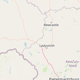
Map view of Weenen Game Reserve

Use this park location map to pinpoint Weenen Game Reserve in South Africa, understand its exact geographic position, and read its mapped placement within the surrounding landscape more clearly.

Pigeon | © OpenStreetMap contributors

Location context for Weenen Game Reserve

KwaZulu-Natal
Park atlas

Compare regional conservation landscapes and nearby savanna habitats

Explore Parks Near Weenen Game Reserve and Surrounding Protected Areas

Browse other protected areas and regional reserves located near Weenen Game Reserve. Compare surrounding savanna terrains and regional wildlife habitats across inland KwaZulu-Natal.
Protected areaKwaZulu-Natal
About 49 km away#1 closest

Southwest

uKhahlamba-Drakensberg Park: Protected Mountain Landscapes and Escarpment Geography in South Africa

Exploring the basalt cliffs and alpine plateau of KwaZulu-Natal.

uKhahlamba-Drakensberg Park encompasses an expansive protected region where the Drakensberg escarpment rises sharply from the foothills of KwaZulu-Natal. This atlas record details the park landscape, including its transition from sandstone terraces to high-altitude basalt, its extensive river gorges, and the concentration of archaeological cave sites. Use this resource to understand the geographic scale of this transboundary conservation area.

Area
2,429.13 km²
Relief
Mountain
Climate
Temperate
Access
Access unknown
A watercolor illustration featuring soft, green rolling hills in the foreground with pale, layered mountain peaks in the background, set against a plain white field.
Protected areaKwaZulu-Natal
About 49 km away#2 closest

Southwest

Maloti-Drakensberg Park Geography: Mountain Escarpments and Alpine Plateau Exploration

A transboundary protected landscape spanning South Africa and Lesotho

Spanning the core of the Drakensberg mountain system, Maloti-Drakensberg Park provides a unique window into high-altitude biodiversity and geological drama. The protected area features basalt cliffs, rolling valleys, and an extensive plateau, forming a critical ecological and cultural corridor. This atlas entry covers the topographic features and spatial distribution of one of southern Africa's most significant protected landscapes.

Area
2,493.13 km²
Established
2001
Relief
Mountain
Climate
Alpine
A soft watercolor painting of a serene landscape with rolling hills in the background; a body of water in the midground; and grassy plains with a few scattered trees in the foreground.
Nature reserveKwaZulu-Natal
About 50 km away#3 closest

West

Spioenkop Dam Nature Reserve: Mapping KwaZulu-Natal Reservoir Landscapes and Heritage

Explore aquatic habitats and historic inland terrain.

Spioenkop Dam Nature Reserve serves as a focal point for protected biodiversity and historical land use in KwaZulu-Natal. The reserve spans a significant impoundment, creating a verdant aquatic habitat that contrasts with the surrounding grasslands and woodland terrain. Users can examine the park's boundaries and topographic features, including the historic Spion Kop battlefield that rises above the reservoir to anchor the northern landscape.

Area
44 km²
Established
1975
Relief
Upland
Climate
Temperate
Nature reserveKwaZulu-Natal
About 88 km away#4 closest

South

Impendle Nature Reserve: Protecting Endangered Grasslands and Mistbelt Ecosystems

A highland conservation sanctuary in the KwaZulu-Natal region

Located in the mist-prone foothills of the Drakensberg, Impendle Nature Reserve stands as a critical block of surviving Midlands Mistbelt Grassland. The reserve terrain combines rugged dolerite ridges with moisture-rich seepage zones and wetlands, providing a specialized habitat for threatened bird species. This protected area remains a significant site for regional biodiversity, emphasizing scientific conservation over expansive development within the KwaZulu-Natal landscape.

Area
30.46 km²
Established
1983
IUCN
IV
Relief
Upland
State or regional parkKwaZulu-Natal
About 104 km away#5 closest

West

Royal Natal National Park: State or Regional Park in KwaZulu-Natal's Geography

Mapped boundaries and landscape context for South African protected areas.

Royal Natal National Park serves as a vital protected landscape within the diverse geography of KwaZulu-Natal, South Africa. This state or regional park offers a focused point for atlas exploration, allowing for a detailed understanding of its mapped boundaries and regional significance. By examining Royal Natal National Park, users can gain specific insights into South Africa's network of protected natural areas and their distribution, enriching overall geographic comprehension.

Area
80.94 km²
Established
1916
Relief
Mountain
Access
Moderate access
National parkFree State
About 122 km away#6 closest

West

Golden Gate Highlands National Park: Protected Area Atlas & Geographic Exploration

Mapping the natural terrain and boundaries of this national park.

Understand the geographic scope and protected landscape of Golden Gate Highlands National Park. This detail page provides an atlas-informed perspective on its natural terrain, mapped boundaries, and regional context within South Africa's Free State. It serves as a foundational entry point for exploring the park's specific geography and protected-area status.

Area
340 km²
Established
1963
Relief
Mountain
Climate
Temperate
A soft, artistic watercolor painting showing rolling green hills in the background with a winding path and fields in the foreground, set against a white background.
Wildlife reserveKwaZulu-Natal
About 126 km away#7 closest

Northeast

Babanango Game Reserve: Exploring Geographic Boundaries and Rewilding Landscapes

Protected wildlife habitats in central KwaZulu-Natal

Centrally positioned in the White Umfolozi River valley, Babanango Game Reserve serves as a model for large-scale biodiversity restoration. Its terrain features a mix of mistbelt grasslands, thornveld, and river frontage supported by ancient geological structures. The reserve preserves both ecological integrity and cultural heritage near historic sites, reflecting a shift toward community-led conservation in modern South African landscape management.

Area
200 km²
Established
2017
Relief
Mixed relief
Climate
Subtropical
Nature reserveKwaZulu-Natal
About 133 km away#8 closest

Southwest

Coleford Nature Reserve: Protected Grasslands and Wetlands in KwaZulu-Natal

Tracing the landscape of a key Drakensberg foothill reserve

The Coleford Nature Reserve represents a critical protected area in the Southern Drakensberg, featuring threatened Drakensberg Foothill Moist Grassland. Its landscape is defined by the Ngwagwane River valley and diverse wetland systems, providing essential habitat for endangered bird species. This reserve functions as a gateway to the broader montane geography of the southwestern KwaZulu-Natal region.

Area
12.72 km²
Established
1948
IUCN
IV
Relief
Highland

Common questions about visiting, size, designation, and location context for Weenen Game Reserve

Weenen Game Reserve FAQs for park facts, access, geography, and protected area context

Find quick answers about Weenen Game Reserve, including protected-area facts, park geography, trail and visitor context, and how the park fits into its surrounding country and regional landscape.
MoriAtlas Explorer

Continue Your Protected Areas Search Across the Global Atlas

Deepen your exploration by continuing the structured search for national parks and protected areas worldwide. Utilize the comprehensive filtering capabilities to compare different conservation landscapes and refine your understanding of global park geography. Discover more about the distribution and characteristics of protected natural areas.

Global natural geography