

Mori Atlas logo
Wildlife reserveWellers Bay National Wildlife Area

Mapping the natural littoral systems and island habitats of southern Ontario

Wellers Bay National Wildlife Area: A Protected Coastal and Barrier Beach Geography

(Réserve nationale de faune de la Baie-Wellers)

Wellers Bay National Wildlife Area serves as a rare, compact protected landscape along the northern shore of Lake Ontario. This wildlife reserve preserves a significant mosaic of barrier beaches, forested islands, and shallow bay waters that remain largely untouched by development. The site functions as a critical stopover for migratory waterfowl and a breeding ground for diverse songbird species, representing an ecologically essential fragment of the original Great Lakes shoreline.

national wildlife areaLake Ontario shorelinebarrier beachislandsbird habitatmigratory birds

Wellers Bay National Wildlife Area

Wildlife reserve

Park overview

Structured park overview, official facts, and landscape profile for Wellers Bay National Wildlife Area

Wellers Bay National Wildlife Area park facts, protected area profile, and essential visitor context

Review the core facts for Wellers Bay National Wildlife Area, including designation, size, terrain, visitor scale, habitats, and operating context in one park-focused overview.

About Wellers Bay National Wildlife Area

Wellers Bay National Wildlife Area sits along the northern shore of Lake Ontario in Prince Edward County, Ontario, just south of the city of Trenton. Managed by the Canadian Wildlife Service, it is a federally designated National Wildlife Area, one of a network of such reserves across Canada focused on the protection of habitats important to migratory birds, breeding species, and species at risk.

The wildlife area is unusual in being composed of a set of distinct but closely linked habitat units. The Baldhead peninsula forms the mainland anchor, Baldhead Beach constitutes a sandy barrier shoreline, and the islands of Bald and Fox rise from the shallow waters of Wellers Bay itself. Together these elements create a rare surviving example of an undeveloped, barrier-type littoral landscape on the Canadian side of Lake Ontario, a type of shoreline that has been extensively modified elsewhere by cottage development and shoreline armoring.

The reserve's compact size contrasts with its disproportionate ecological value. Its forested islands provide secure nesting habitat for songbirds and other woodland species, while the adjacent open waters of Lake Ontario offer feeding and resting conditions for waterfowl, grebes, loons, and scoters during migration. Open habitats nearby support grassland species such as the loggerhead shrike and the upland sandpiper. Multiple species at risk have been documented within or immediately around the area.

The wildlife area reflects a typical southern Ontario conservation challenge: protecting extremely limited remaining natural shoreline within a landscape that is otherwise heavily settled, farmed, and developed. Its history, beginning with a land transfer from the Department of National Defence in 1969 and culminating in formal National Wildlife Area designation in 1977, illustrates the intentional use of surplus federal lands to create durable habitat protection along the Great Lakes.

Quick facts and research context for Wellers Bay National Wildlife Area

Wellers Bay National Wildlife Area is a Canadian federal wildlife reserve located on the northern shore of Lake Ontario in Prince Edward County, Ontario, south of Trenton. The site is composed of the Baldhead peninsula, Baldhead Beach, and the islands of Bald and Fox, surrounding a small area of open Lake Ontario water. It is managed by the Canadian Wildlife Service and was formally established as a National Wildlife Area in 1977, following an earlier 1969 transfer of the land from the Department of National Defence. With an IUCN Category Ia designation, the area is recognized for its strict nature protection character. The wildlife area protects one of the last wild barrier littoral systems on the Canadian side of Lake Ontario.

Protection and recognition

Examine terrestrial protected area designations and official conservation status records

Wellers Bay National Wildlife Area Protection Status and Formal Recognition Records

Terrestrial protected area records establish the official conservation framework and management scope for Wellers Bay National Wildlife Area. Documented protection status details provide verified baseline data for analyzing international recognition metrics and geographic boundaries.

Protection details

Protection scope
Terrestrial
WDPA ID
18199
Park context

Deeper park guide and search-rich context for Wellers Bay National Wildlife Area

Wellers Bay National Wildlife Area history, landscape, wildlife, and travel context

Explore Wellers Bay National Wildlife Area through its history, landscape character, ecosystems, wildlife, conservation priorities, cultural context, and seasonal travel timing in a structured park guide built for atlas discovery and search intent.

Why Wellers Bay National Wildlife Area stands out

Wellers Bay National Wildlife Area is best known for protecting one of the last remaining wild barrier beach and littoral systems on the Canadian shoreline of Lake Ontario. Within a very small total area it combines forested islands, an undeveloped barrier beach, and open lake habitat in a way that is increasingly rare along this heavily populated lakeshore. The wildlife area is also strongly associated with birdlife, both as a breeding ground for songbirds and raptors on its wooded islands and as a stopover for migrating waterfowl and other waterbirds moving along Lake Ontario. The presence of several species at risk adds to its regional conservation importance, making the reserve a small but ecologically heavy-weight protected site in southern Ontario.

Wellers Bay National Wildlife Area history and protected-area timeline

The history of Wellers Bay National Wildlife Area begins in 1969, when the Canadian Department of National Defence transferred the Baldhead peninsula, Baldhead Beach, and the islands of Bald and Fox to the Canadian Wildlife Service. The transfer was carried out specifically to enable the establishment of a protected area on this stretch of Lake Ontario shoreline, where natural coastal features were already under strong development pressure.

Following the transfer, conservation planning moved forward over the following years, and the area was formally established as a National Wildlife Area in 1977. From that point onward it has been managed by the Canadian Wildlife Service as part of the federal network of National Wildlife Areas, with a focus on protecting habitat values and limiting further alteration of the shoreline and islands.

Although short in formal chronology, the history of the site reflects a broader pattern in southern Ontario conservation: small parcels of land, often acquired through unusual channels such as military transfers, becoming the last refuges for natural shoreline habitats that have largely disappeared from the surrounding region.

Wellers Bay National Wildlife Area landscape and geographic character

The landscape of Wellers Bay National Wildlife Area is defined by its position directly on the northern shore of Lake Ontario. The protected area combines four principal physical elements: the Baldhead peninsula on the mainland, the sandy Baldhead Beach forming a barrier shoreline, the islands of Bald and Fox lying just offshore, and the shallow bay waters of Wellers Bay that tie these features together.

The barrier beach at Baldhead is one of the most distinctive landscape features of the reserve. It is part of the small remaining set of natural, undeveloped barrier littoral systems on the Canadian side of Lake Ontario, most of which have been lost to cottage construction, dredging, or shoreline stabilization. The adjacent forested islands add elevation, shelter, and structural diversity to what would otherwise be a low, exposed shoreline environment.

The result is a compact but visually varied landscape. From open sand beach and shallow bay waters, the scene shifts quickly to wooded island interiors and then back to sheltered embayments along the mainland peninsula. The terrain is generally low-lying, shaped by long-term shoreline and lake-level processes rather than by dramatic relief, and the scenery reads as quiet, lake-edge wilderness rather than rugged topography.

Wellers Bay National Wildlife Area ecosystems, habitats, and plant life

The natural environment of Wellers Bay National Wildlife Area is shaped by the meeting of lake, beach, lowland woodland, and meadow habitats within a very small area. These habitats reflect the typical ecological character of the northern Lake Ontario shoreline and provide a narrowly compressed but ecologically rich cross-section of southern Ontario coastal ecosystems.

The forested islands offer the most sheltered terrestrial conditions, supporting nesting songbirds, wood-warblers, vireos, flycatchers, and thrushes in the canopy and understory. The sandy barrier beach and adjacent dunes create specialized conditions for ground-nesting and shoreline species, while open grassy habitats on the mainland side of the area provide habitat for grassland birds, including species of conservation concern such as the loggerhead shrike and the upland sandpiper.

The bay waters themselves are an important part of the ecological system. They serve as feeding and resting habitat for migratory diving ducks, scoters, grebes, and the common loon. The combination of sheltered bay, open lake access, forested nesting islands, and undeveloped beach makes the wildlife area a functional ecological unit rather than a single uniform habitat, and this habitat diversity is central to its conservation significance.

Wellers Bay National Wildlife Area wildlife and species highlights

Wildlife is the defining focus of Wellers Bay National Wildlife Area, as implied by its protection category. The wildlife area is most notable for its birdlife, which uses different parts of the reserve at different times of the year.

The forested islands provide breeding habitat for a variety of songbirds, including wood-warblers, vireos, flycatchers, and thrushes, which find secure nesting cover in the island woodlands. Open meadows and grasslands around the reserve host passerines and species such as the loggerhead shrike and the upland sandpiper, both considered species of conservation concern in the region.

The lake and bay waters surrounding the reserve support waterfowl and other waterbirds, especially during migration. Ducks such as scaup, along with long-tailed ducks, white-winged scoters, common loons, and grebes, use the area as a stopover on Lake Ontario. Species at risk documented in and around the reserve include the least bittern, the piping plover, and the monarch butterfly, along with two snake species, the eastern hog-nosed snake and the eastern ribbon snake, highlighting that the wildlife area's importance extends beyond birds.

Wellers Bay National Wildlife Area conservation status and protection priorities

From a conservation perspective, Wellers Bay National Wildlife Area is significant despite its very small size because it protects a type of shoreline that is increasingly rare on the Canadian side of Lake Ontario. The site's barrier beach and associated littoral landscape have largely disappeared elsewhere in the region under the pressure of lakeshore development, leaving only a few remaining natural examples. The wildlife area is one of those survivors and is therefore disproportionately important to regional habitat protection.

The area also contributes to broader conservation networks. As a federally designated National Wildlife Area managed by the Canadian Wildlife Service, it is part of a national system focused on migratory birds, breeding habitats, and species at risk. Its documented presence of multiple species at risk, including the least bittern, piping plover, monarch butterfly, eastern hog-nosed snake, and eastern ribbon snake, gives the site a real role in protecting biodiversity in southern Ontario.

Protection status under the National Wildlife Area framework also means that habitat alteration, development, and recreational pressure within the reserve are managed and constrained, helping to keep the shoreline in a natural state. This has long-term significance for maintaining the ecological functions of the bay and for protecting a continuing refuge for native species in an otherwise heavily modified regional landscape.

Wellers Bay National Wildlife Area cultural meaning and human context

Wellers Bay National Wildlife Area sits in Prince Edward County, a region with a long history of lakeshore settlement, farming, and more recent tourism and cottage development along Lake Ontario. The wildlife area represents a deliberate effort to set aside a small fragment of the original shoreline character of the region within a landscape that has otherwise been substantially altered by human activity.

The reserve's origin in a 1969 land transfer from the Department of National Defence also reflects an interesting institutional history, in which military lands along the Great Lakes were repurposed for conservation purposes at a time when environmental awareness around the lakes was growing. This context situates the wildlife area within both the conservation history of southern Ontario and the broader story of Great Lakes shoreline protection.

Top sights and standout views in Wellers Bay National Wildlife Area

Wellers Bay National Wildlife Area stands out for the unusual concentration of natural shoreline habitat types preserved within a very small protected footprint. The combination of forested islands, an undeveloped barrier beach, and Lake Ontario bay waters provides an ecological snapshot that is otherwise almost absent from the heavily developed Canadian shoreline of the lake.

Both breeding and migratory wildlife benefit from this diversity. Songbirds breed on the islands, grassland species use the open habitats, and the bay waters support waterfowl, grebes, loons, and scoters during migration. The presence of multiple species at risk adds weight to the reserve's profile, making it a small but high-value site for bird-focused and shoreline-habitat conservation in southern Ontario.

Best time to visit Wellers Bay National Wildlife Area

Wellers Bay National Wildlife Area is most rewarding to experience during the spring and fall migration periods, when Lake Ontario's shoreline becomes a major flyway for waterfowl, grebes, loons, and other waterbirds. These seasons offer the best chances to observe migratory species using the bay waters and the deeper lake beyond the reserve.

Late spring and early summer are also valuable for those interested in breeding songbirds on the forested islands, as well as for observing grassland species in the open habitats around the reserve. Summer visitors may encounter a quieter scene, while winter typically brings reduced waterbird activity but still offers a starkly beautiful landscape of frozen bay, low islands, and open lake. Because this is a federally managed wildlife area with limited public access, any visit should be planned in accordance with current Canadian Wildlife Site guidance rather than as a typical park outing.
Monthly climate preview

Long-term monthly temperature averages and precipitation records for Ontario protection

Wellers Bay National Wildlife Area Climate Normals and Annual Weather Patterns

Representative coordinates record sustained temperature shifts alongside steady monthly precipitation levels across the conservation terrain. Examining the complete twelve-month climatology dataset reveals detailed numerical baselines for this protected Ontario landscape.
Annual mean8 °C
-5 °C21 °C
Jan-5°
Feb-5°
Mar
Apr
May11°
Jun17°
Jul21°
Aug21°
Sep17°
Oct11°
Nov
Dec-1°
Warmest month
July

21.2 °C

Coolest month
January

-4.9 °C

Wettest month
June

2.4 mm/day

Driest month
February

1.7 mm/day

Park location guide

Geography guide, regional context, and park location map for Wellers Bay National Wildlife Area

Wellers Bay National Wildlife Area park geography, regions, and map view in Canada

Understand where Wellers Bay National Wildlife Area sits in Canada through a broader geographic reading of the surrounding landscape, nearby location context, and its mapped position within the national park landscape.

How Wellers Bay National Wildlife Area fits into Canada

Canada is a federal parliamentary constitutional monarchy spanning North America from the Atlantic to the Pacific and Arctic Oceans. With a population of over 41 million, it is officially bilingual in English and French at the federal level. The country gained independence from the United Kingdom through a gradual process culminating in 1982.

Wider geography shaping Wellers Bay National Wildlife Area in Canada

Canada occupies the northern portion of North America, sharing its longest international border with the United States. The country extends from the Atlantic Ocean to the Pacific Ocean and northward into the Arctic Ocean, giving it the longest coastline of any nation.

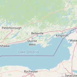
Map view of Wellers Bay National Wildlife Area

Use this park location map to pinpoint Wellers Bay National Wildlife Area in Canada, understand its exact geographic position, and read its mapped placement within the surrounding landscape more clearly.

Pigeon | © OpenStreetMap contributors

Location context for Wellers Bay National Wildlife Area

Ontario
Park atlas

Compare regional lake habitats, barrier beaches, and connected conservation terrain across southeastern Ontario

Exploring Parks Near Wellers Bay National Wildlife Area and Surrounding Protected Landscapes

Browsing other protected areas near Wellers Bay National Wildlife Area reveals broader ecological connections along the northern shore of Lake Ontario. Regional park comparison highlights how different shoreline reserves preserve vital bird habitats and fragile coastal terrain.
Wildlife reserveOntario
About 59 km away#1 closest

East

Prince Edward Point National Wildlife Area: Protected Geography and Migration Hub

Coastal woodland and shoreline terrain in southeastern Ontario

Prince Edward Point National Wildlife Area is a federal reserve located on a narrow peninsula extending into Lake Ontario. This area features a diverse landscape of forest patches, open meadows, and jagged lakefront, providing critical refuge for migrating bird species. As a long-standing center for ornithological research, the site remains an essential node for understanding the regional migration patterns and natural heritage of the Great Lakes basin.

Area
5.6 km²
Established
1980
IUCN
Ia
Relief
Lowland
Watercolor painting of green hills, islands, and a body of water under a pale yellow sky
National parkOntario
About 78 km away#2 closest

East

Thousand Islands National Park: Exploring Ontario's Protected Landscape Geography

Discover the mapped terrain and regional context of this national park.

Uncover the protected landscape identity of Thousand Islands National Park, a key national park located in Ontario. This resource focuses on its geographic setting, mapped boundaries, and overall atlas context, providing a clear understanding of its role as a protected area. Explore how its unique terrain contributes to the regional geography and the broader national park network, offering valuable insight for landscape-focused discovery.

Area
24.4 km²
Established
1904
IUCN
II
Visitors
109.3K annual
Marine protected areaNew York
About 88 km away#3 closest

Southeast

Lake Ontario National Marine Sanctuary: Geographic Atlas and Protected Area Overview

Mapping freshwater maritime heritage and coastal New York landscapes.

Spanning the southeastern waters of Lake Ontario, this marine protected area safeguards dozens of historic shipwrecks and vital Indigenous cultural sites. This atlas entry provides geographic context on the sanctuary boundaries, submerged archaeological zones, and the surrounding New York freshwater environment.

Area
4,460 km²
Established
2024
IUCN
V
Relief
Lowland
National parkOntario
About 124 km away#4 closest

West

Rouge National Urban Park: Ontario's Mapped Protected Landscape Atlas

Explore national park boundaries and regional geography.

Investigate Rouge National Urban Park, a designated national park situated in Ontario, Canada. This page provides detailed atlas-style information focusing on its mapped boundaries, regional geographic context, and its identity as a significant protected natural landscape. Understand the park's role within the broader Canadian atlas for landscape exploration.

Area
79.1 km²
Established
2015
IUCN
V
Relief
Mixed relief
Wildlife reserveOntario
About 158 km away#5 closest

Northeast

Zugvogelschutzgebiet Mississippi Lake Protected Landscape and Wildlife Reserve Atlas

Waterfowl habitat and wetland geography in Ontario

Zugvogelschutzgebiet Mississippi Lake serves as a designated wildlife reserve providing essential staging grounds for migratory waterfowl. Located at the river-mouth interface on Mississippi Lake, the area encompasses provincially significant wetlands within Ewan Bay. This protected footprint offers a distinct look at the quiet, low-relief hydrology and marsh ecology characteristic of the broader southern Ontario basin.

Area
2.84 km²
Established
1959
IUCN
IV
Relief
Lowland
Wildlife reserveOntario
About 170 km away#6 closest

Northeast

Rideau Migratory Bird Sanctuary: Protected Wildlife Reserve and Regional Waterfowl Habitat

Riparian conservation zones along the Rideau River in Ontario

The Rideau Migratory Bird Sanctuary protects a strategically important riparian corridor within Ontario. This federal wildlife reserve provides essential refuge for migratory birds along the Rideau River system, offering a specialized look at the region's diverse wetland margins and floodplain geography.

Area
7.52 km²
Established
1957
Wildlife reserveOntario
About 180 km away#7 closest

Northwest

Eleanor Island Wildlife Reserve: Protected Ontario Lake Landscape and Bird Habitat

A federal migratory bird sanctuary in the Canadian Shield

Eleanor Island is a strictly protected migratory bird sanctuary in Ontario that serves as a vital nesting ground for colonial waterbirds. Positioned within Lake Muskoka, this small but ecologically purposeful nature reserve demonstrates the importance of localized federal protection for regional breeding populations. Its status as a strict nature reserve underscores a commitment to safeguarding sensitive habitats within the broader Canadian Shield wilderness.

Area
0.006 km²
Established
1978
IUCN
Ia
Relief
Lowland
National parkOntario
About 198 km away#8 closest

Northwest

Georgian Bay Islands National Park: Ontario National Park Protected Landscape Atlas

Explore mapped boundaries and regional geographic context.

Gain a comprehensive understanding of Georgian Bay Islands National Park as a distinct protected area within Ontario. This entry provides detailed geographic context, focusing on the park's mapped landscape, its protected status as a national park, and its position within the regional geography of Canada. It is designed for users seeking structured information about protected lands and their atlas-level significance.

Area
13.5 km²
Established
1929
IUCN
II
Visitors
27.5K annual

Common questions about visiting, size, designation, and location context for Wellers Bay National Wildlife Area

Wellers Bay National Wildlife Area FAQs for park facts, access, geography, and protected area context

Find quick answers about Wellers Bay National Wildlife Area, including protected-area facts, park geography, trail and visitor context, and how the park fits into its surrounding country and regional landscape.
MoriAtlas Explorer

Continue Your Protected Areas Search Across the Global Atlas

Deepen your exploration by continuing the structured search for national parks and protected areas worldwide. Utilize the comprehensive filtering capabilities to compare different conservation landscapes and refine your understanding of global park geography. Discover more about the distribution and characteristics of protected natural areas.

Global natural geography
