

Mori Atlas logo
Nature reserveWellington Caves

Mapping the underground chambers, subterranean lakes, and ancient Devonian strata of central New South Wales

Wellington Caves Nature Reserve: A Geological Atlas of Limestone Karst and Fossil Landscapes

Wellington Caves sits as a prominent limestone karst protected area within the gently undulating country of central western New South Wales. This reserve is defined by a 400 million year old outcrop of Devonian limestone that houses an expansive network of chambers, dolines, and drowned passages. Beyond the surface, the site serves as a foundational paleontological reference point, preserving significant Pleistocene fossil records and intricate speleological formations that reveal deep geological history.

karst caveslimestone cavesshow cavesfossil sitepaleontologymegafauna fossils

Wellington Caves

Nature reserve

Park overview

Structured park overview, official facts, and landscape profile for Wellington Caves

Wellington Caves park facts, protected area profile, and essential visitor context

Review the core facts for Wellington Caves, including designation, size, terrain, visitor scale, habitats, and operating context in one park-focused overview.

About Wellington Caves

Wellington Caves occupies a small but geologically rich corner of central western New South Wales, where ancient limestone meets a landscape shaped by tens of millions of years of weathering and groundwater activity. The protected caves lie just south of the town of Wellington, in an outcrop of Early Devonian Garra Formation limestone around 400 million years old. From this bedrock, slow-moving water has dissolved out an extensive system of chambers, shafts, dolines, and flooded passages, creating one of the more varied karst landscapes in the state.

What sets the reserve apart is the way natural beauty, deep time, and scientific history come together. Cathedral Cave, the earliest of the show caves and the one depicted in Augustus Earle's 1826 painting, is dominated by Altar Rock, a vast stalagmite that defines the chamber. Gaden Cave, discovered in 1902 and opened to the public in 1909, is admired for fragile and unusual cave coral formations. The Phosphate Mine, reopened for tours in 1996, leads visitors through historic workings where 800,000-year-old fossil-bearing deposits are still exposed. Together these three show caves form the public face of the reserve.

Behind that public face lies a much larger underground network, more than two dozen known caves, several of them partly or wholly water-filled. Explorers from the Sydney University Speleological Society have spent decades mapping and diving in the system, locating submerged chambers, a subterranean lake beneath Lime Kiln Cave, and smaller doline caves such as Anticline Cave. Cathedral Cave also holds paleontological significance beyond its showpiece formations: an excavation there produced bones of Macroderma koppa, an extinct relative of the modern ghost bat that roosted in the cave during the Pliocene.

The reserve's identity also draws on a longer Indigenous and colonial history. The Wiradjuri people of the Wellington region knew the caves as Mulwang and associated them with a spirit named Koppa, the same name later applied to the fossil bat. European exploration began with Lieutenant Percy Simpson's settlement in the 1820s, then with Hamilton Hume's 1828 written account, and culminated in George Ranken and Sir Thomas Mitchell's landmark 1830 fossil collection. From the 1880s onward, vandalism prompted protection, regular guided tours began, and the caves eventually grew from an outback curiosity into a regional tourism anchor with thousands of visitors each year.

Quick facts and research context for Wellington Caves

Wellington Caves is a karst cave system in New South Wales, Australia, set in roughly 400-million-year-old Early Devonian limestone that belongs to the Garra Formation. The reserve sits about 8 kilometres south of the town of Wellington and currently includes around 26 known caves within its boundaries. The site has been a declared natural reserve since 1884 and is now operated as a tourist destination with guided tours, a visitor centre, a caravan park, and supporting accommodation.

The caves have long been recognised as a major paleontological locality. They produced some of the first Australian fossils taken up for scientific study in the 1830s, including diprotodon remains and giant kangaroo bones, and they later yielded a previously unknown species of bat described from Cathedral Cave. The location also carries strong cultural associations with the Wiradjuri people of the Wellington region, who knew the caves as Mulwang.

Protection and recognition

Terrestrial conservation scope, designation history, and administrative records

Wellington Caves Protection Status and International Recognition Details

Terrestrial protection status, management scope, and administrative records outline the conservation framework established for Wellington Caves. Structured facts bring together documented designation data and official recognition sources for comprehensive analysis.

Protection details

Protection scope
Terrestrial
Transboundary protection
No
Park context

Deeper park guide and search-rich context for Wellington Caves

Wellington Caves history, landscape, wildlife, and travel context

Explore Wellington Caves through its history, landscape character, ecosystems, wildlife, conservation priorities, cultural context, and seasonal travel timing in a structured park guide built for atlas discovery and search intent.

Why Wellington Caves stands out

Wellington Caves is best known for being one of Australia's foundational paleontological sites, supplying some of the very first megafauna fossils, including diprotodon and giant kangaroo remains, that were brought to the attention of European science in the 1830s. The reserve is also celebrated for Cathedral Cave's Altar Rock, a colossal stalagmite more than 15 metres high and 32 metres in circumference, and for Gaden Cave's fine cave coral formations. Beyond its show caves, Wellington is recognised for the breadth of its karst: more than two dozen known caves, drowned passages and subterranean lakes mapped largely with the help of cave divers from the Sydney University Speleological Society. The site therefore stands out as both a visitor attraction and a continuing reference point for Australian speleology and Quaternary paleontology.
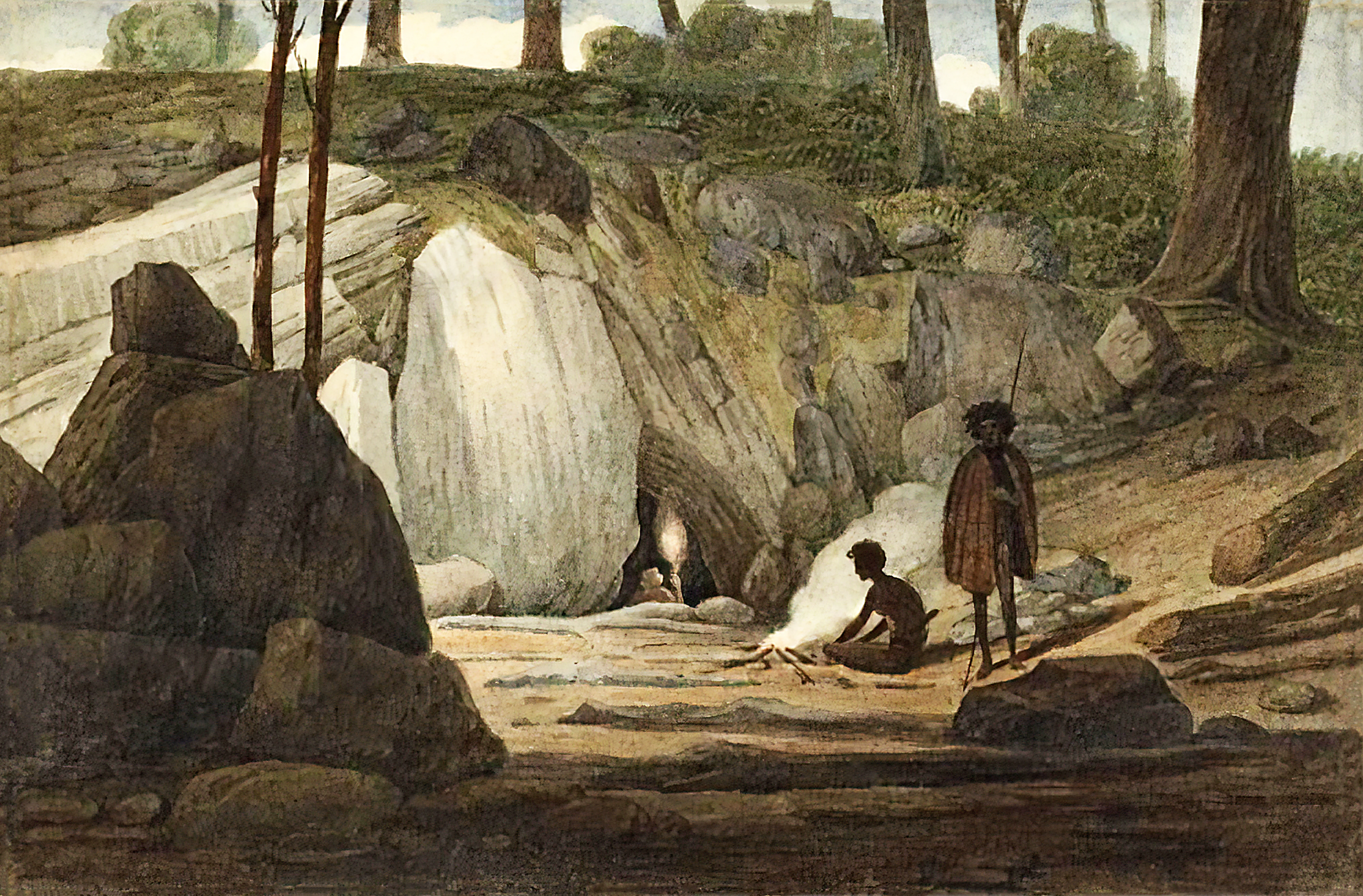
A historical watercolor painting depicting two figures sitting near a campfire outside a limestone cave entrance in a wooded area.
An 1830s watercolor painting of the entrance to Mosman's Cave in the Wellington Valley.

Wellington Caves history and protected-area timeline

The human history of the Wellington Caves extends well before European arrival. The Binjang mob of the Wiradjuri long inhabited the Wellington region and knew the caves by the name Mulwang. There is no direct evidence that they entered the cave passages themselves, but the entrances were familiar features of the landscape, and informants later associated a mythological spirit called Koppa with the caves. That name would resurface generations later when a fossil bat recovered from Cathedral Cave was formally named Macroderma koppa.

European contact began in 1826, when the artist Augustus Earle visited the Wellington Valley and produced a painting showing Aboriginal people around a fire at the entrance of what is now Cathedral Cave. The first written European account came in 1828 from the explorer Hamilton Hume. The decisive moment for the caves' scientific reputation came in 1830, when local magistrate George Ranken discovered fossil bones of a diprotodon and a giant kangaroo. Returning later that year with the Surveyor General of New South Wales, Sir Thomas Mitchell, Ranken collected a large quantity of bones from what appears to have been a natural trap for ancient fauna. Mitchell presented these finds to the Geological Society of London in 1831, placing Wellington Caves on the map of world paleontology.

Throughout the nineteenth century the caves suffered vandalism until 1884, when the area was declared a natural reserve. Organised tours of Cathedral Cave began around 1885 with the appointment of the first caretaker, James Sibbald. By 1888, more than 1,500 visitors a year were coming to see the formations. Gaden Cave was discovered in 1902 and opened for tours in 1909, while a phosphate mine operated in the reserve from 1914 to 1918 before being abandoned.

From the late 1950s onward, the Sydney University Speleological Society took a leading role in exploring the system. Its members, particularly its cave divers, mapped and extended many sections of the caves, bringing the total of known caves in the reserve to around 26 and producing important discoveries including McCavity Cave, a subterranean lake under Lime Kiln Cave, and the rediscovery of Anticline Cave. In the modern era, the long-abandoned phosphate workings were reconstructed and reopened for guided tours in 1996, and a new Visitor Experience Centre, complete with cafe, museum exhibition, and discovery classroom, was added in 2019.

Wellington Caves landscape and geographic character

The landscape of Wellington Caves is defined above all by the limestone that hosts it. The caves are developed in an outcrop of Early Devonian limestone from the Garra Formation, roughly 400 million years old, lying in the otherwise gently undulating countryside of central western New South Wales, about 8 kilometres south of the town of Wellington. From the surface, the reserve appears as a subtle rise of rocky ground dotted with entrance dolines, sinkholes, and low exposures of pale rock, rather than as dramatic cliffs or escarpments.

Beneath this ordinary-looking surface lies a rich karst terrain. Water working through the limestone over geological timescales has created chambers of varying sizes, from the lofty vault of Cathedral Cave, dominated by Altar Rock, to the tighter, more ornamented passages of Gaden Cave. Several caves, including Lime Kiln Cave and McCavity, are partly or wholly flooded, with submerged passages and a known subterranean lake. Big Sink is an old collapsed doline that appears to be the route through which fossil-bearing sediments once washed down into the chambers below, helping to explain the site's paleontological richness.

The scenery is therefore primarily subterranean, and the surface around the reserve has been shaped to accommodate visitors: a caravan park, motel, camping facilities, a swimming pool, and the newer Visitor Experience Centre opened in 2019. Even so, the broader setting still reads as quiet Australian bush country, with the caves sitting as a cool, mineral contrast to the dry land above them.

Wellington Caves conservation status and protection priorities

Wellington Caves' conservation significance is rooted less in standing ecosystems and more in the protection of a fragile underground environment and an irreplaceable fossil record. Declared a natural reserve in 1884 in response to nineteenth-century vandalism, the area has since been managed to balance public access with the careful preservation of its karst. The caves function as a natural archive, having acted as a trap for ancient fauna whose bones accumulated over hundreds of thousands of years, and the protection of the reserve means these deposits continue to be available for modern research.

The site is also important for bat research and conservation awareness. The extinct Pliocene species Macroderma koppa, named for the Wiradjuri spirit Koppa associated with Cathedral Cave, links the reserve to living relatives such as the modern ghost bat. Today, managing visitor flow through Cathedral, Gaden, and the Phosphate Mine helps protect delicate formations, including Altar Rock and the cave coral in Gaden Cave, from wear and damage. Ongoing exploration by groups such as the Sydney University Speleological Society is coordinated with reserve management, extending knowledge of the system while supporting its long-term protection.

Wellington Caves cultural meaning and human context

The Wellington Caves carry a strong and continuous cultural layer that long predates their European rediscovery. The Binjang mob of the Wiradjuri people inhabited the Wellington region and knew the caves as Mulwang, associating them with a spirit called Koppa who was believed to inhabit the site. Whether or not they ventured deep into the passages, the entrances were a known and meaningful part of the local landscape.

European engagement added a second cultural strand. Augustus Earle's 1826 painting at the mouth of Cathedral Cave is one of the earliest visual records of European interaction with the caves and was produced just a few years after the first colonial settlement in the Wellington Valley. Within a few more years the caves had become a touchstone of Australian scientific history through the 1830 fossil discoveries and Sir Thomas Mitchell's 1831 address to the Geological Society of London. The legacy of that engagement is still visible in the way Mitchell's Cave and Big Sink are remembered today, and in the use of the name Koppa for the fossil bat species described from Cathedral Cave, which quietly preserves the original Wiradjuri association within modern science.

Top sights and standout views in Wellington Caves

The standouts of Wellington Caves are the giant Altar Rock stalagmite in Cathedral Cave, the cave coral formations of Gaden Cave, and the 800,000-year-old fossil deposits on display in the reconstructed Phosphate Mine. Beyond the show caves, the reserve contains more than two dozen known caves, including drowned passages and a subterranean lake explored by the Sydney University Speleological Society, as well as historic sites such as Mitchell's Cave and Big Sink. The reserve also delivers a layered cultural story, from the Wiradjuri name Mulwang and the spirit Koppa, through Augustus Earle's 1826 painting, to the foundational diprotodon discoveries of 1830.

Best time to visit Wellington Caves

Wellington Caves is an underground attraction, so its appeal does not depend strongly on surface seasons, but the broader New South Wales climate still shapes the experience. The cooler months from late autumn through early spring tend to offer the most comfortable conditions for combining cave tours with the surrounding bush and outdoor facilities of the reserve, while summer in central western New South Wales can be hot and dry, making the cool, stable temperatures inside the caves particularly welcome. The fossil deposits, cave coral, and Altar Rock are permanent features of the cave environment and are unaffected by season, so the visit is largely a matter of choosing when the above-ground weather best suits travel and outdoor time at the visitor centre and accommodation areas.
Monthly climate preview

Long-term representative coordinate records detailing annual weather by month for New South Wales

Wellington Caves Climate Normals, Average Temperatures, and Monthly Precipitation Patterns

Historical data records long-term monthly temperature swings and precipitation rates across a representative coordinate at Wellington Caves. Reviewing the complete twelve-month profile provides deeper statistical context for analyzing regional climate normals.
Annual mean17 °C
8 °C26 °C
Jan26°
Feb25°
Mar21°
Apr17°
May12°
Jun
Jul
Aug
Sep13°
Oct17°
Nov21°
Dec23°
Warmest month
January

25.8 °C

Coolest month
July

7.9 °C

Wettest month
December

2.1 mm/day

Driest month
April

1 mm/day

Park location guide

Geography guide, regional context, and park location map for Wellington Caves

Wellington Caves park geography, regions, and map view in Australia

Understand where Wellington Caves sits in Australia through a broader geographic reading of the surrounding landscape, nearby location context, and its mapped position within the national park landscape.

How Wellington Caves fits into Australia

Australia is a constitutional monarchy and federal parliamentary democracy comprising six states and ten territories. With a population of nearly 28 million, it is one of the world's most urbanised countries, with most people concentrated on the eastern seaboard. The country has a high Human Development Index and is known for its cultural diversity, ancient Aboriginal heritage, and unique wildlife.

Wider geography shaping Wellington Caves in Australia

Australia occupies the entire Australian continent, the island of Tasmania, and numerous smaller islands. It is the world's flattest and driest inhabited continent, featuring vast deserts in the interior (the Outback), tropical rainforests along the eastern coast, and a coastline bordering the Indian and Pacific Oceans.

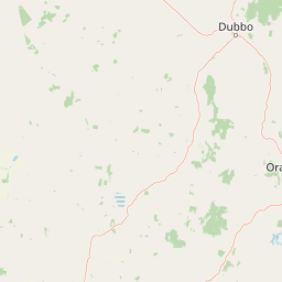
Map view of Wellington Caves

Use this park location map to pinpoint Wellington Caves in Australia, understand its exact geographic position, and read its mapped placement within the surrounding landscape more clearly.

Pigeon | © OpenStreetMap contributors

Location context for Wellington Caves

New South Wales

Visual reference guide to underground chambers, limestone formations, and subterranean terrain.

Wellington Caves Photos and Landscape Imagery: Exploring Karst Scenery

Visual records reveal the complex subterranean terrain, limestone chambers, and ancient karst formations found across Wellington Caves. Examining protected area imagery helps researchers and visitors understand the geological scale and natural environment of the reserve.

A historical watercolor painting depicting two figures sitting near a campfire outside a limestone cave entrance in a wooded area.

Park atlas

Compare regional reserves and surrounding geological formations across central New South Wales.

Explore Parks Near Wellington Caves and Discover Connected Protected Landscapes

Continue exploring protected areas near Wellington Caves to compare regional park geography and subterranean landscapes. Expanding the search helps contextualize central western New South Wales conservation lands within broader natural terrain.
National parkNew South Wales
About 51 km away#1 closest

West

Goobang National Park: Detailed Geographic and Protected Landscape Exploration

Mapped Boundaries and Natural Terrain in New South Wales

Discover the specific geographic features and protected boundaries of Goobang National Park. This entry offers an atlas-focused perspective, highlighting its role as a national park within New South Wales and providing foundational data for understanding its natural landscape and regional setting. Dive into a structured exploration of its mapped terrain and protected status.

Area
421 km²
Established
1995
IUCN
II
Relief
Upland
Nature reserveNew South Wales
About 53 km away#2 closest

Southwest

South West Woodland Nature Reserve: Geographic Overview and Protected Forest Boundaries

A fragmented network of conservation precincts in inland New South Wales

Examine the geographic structure of South West Woodland Nature Reserve, a nature reserve defined by its unusual patchwork of twenty-seven isolated woodland islands. Stretching across 400 kilometres, this protected area anchors crucial white cypress pine and eucalypt forest remnants, forming a transition zone between the South Western Slopes and the arid plains of the Murray Darling Depression.

Area
138.4 km²
Established
2011
IUCN
Ia
Relief
Lowland
National parkAustralia
About 54 km away#3 closest

Northeast

Yarrobil National Park: Australia's Protected Landscape for Geographic Discovery

Explore its national park designation and mapped regional context.

Yarrobil National Park stands as a distinct protected landscape within Australia, identified as a national park. Its geographic significance lies in its contribution to the nation's atlas of conservation areas. This page focuses on providing a clear understanding of the park's identity, its environmental setting, and how its mapped boundaries fit into the broader regional geography of Australia, enabling structured exploration for enthusiasts of protected areas and natural landscapes.

Area
13.22 km²
Established
2005
IUCN
II
Relief
Upland
A watercolor painting of rolling green hills and mountains against a white background with pale pink and yellow washes.
Nature reserveNew South Wales
About 70 km away#4 closest

South

Borenore Karst Conservation Reserve: Exploring Limestone Caves and Volcanic Geology

Protected karst landscapes and fossil heritage in New South Wales

Borenore Karst Conservation Reserve offers a dense concentration of limestone features, including the notable Tunnel Cave and expansive fossil-rich sediments. Its geographic identity is defined by the striking contrast between its sedimentary core and the surrounding volcanic terrain of the Central Tablelands, providing a distinct site for investigating regional earth sciences and subterranean ecology.

Area
1.36 km²
Established
1997
IUCN
III
Relief
Upland
Nature reserveNew South Wales
About 87 km away#5 closest

East

Munghorn Gap Nature Reserve: A Detailed Atlas of Protected Sandstone Landscapes in New South Wales

Transition zone geography on the Great Dividing Range

Munghorn Gap Nature Reserve represents a unique geographic crossing point on the Great Dividing Range. This protected area features dramatic pagoda-like sandstone formations, diverse eucalypt forests, and critical bird habitats that sustain a wide range of species across a rugged and weathered mountain landscape.

Area
59.34 km²
Established
1961
IUCN
Ia
Relief
Mountain
National parkNew South Wales
About 91 km away#6 closest

Northeast

Goulburn River National Park: New South Wales National Park with River Ecosystems and Heritage

Explore mapped protected lands and regional geography.

Goulburn River National Park offers a significant protected landscape within New South Wales, Australia, celebrated for its expansive Goulburn River frontage and diverse natural terrain. This national park is pivotal for understanding regional geography, featuring sandstone geological formations and serving as a critical habitat for endangered species, including the regent honeyeater. Its extensive river corridor also protects numerous Aboriginal heritage sites, contributing a rich layer of cultural significance to its conservation value. MoriAtlas helps users explore the mapped boundaries and environmental context of this vital protected area.

Area
722.96 km²
Established
1983
IUCN
II
Relief
Mixed relief
National parkNew South Wales
About 91 km away#7 closest

Southwest

Nangar National Park: Australian National Park Geography and Mapped Boundaries

Explore the protected landscape within New South Wales.

Nangar National Park is a key protected area situated in New South Wales, Australia, offering a valuable point for geographic discovery. This page details its status as a national park, providing insight into its mapped boundaries and its role within the regional landscape. Users can utilize this information to understand the park's specific geographic context and its contribution to the broader atlas of Australia's protected lands.

Area
94 km²
Established
1983
IUCN
II
Relief
Mountain
National parkNew South Wales
About 107 km away#8 closest

East

Wollemi National Park: Mapping Australia's Protected Natural Landscape in New South Wales

Detailed geographic context and protected area exploration.

Wollemi National Park is a critical component of New South Wales' protected natural areas, offering rich opportunities for geographic discovery. This national park provides a distinct focus for understanding the mapped terrain and regional landscape context of Australia. Explore its position within New South Wales, uncovering the details that define its unique protected status and natural geography for dedicated atlas exploration.

Area
5,017.03 km²
Established
1979
IUCN
Ib
Relief
Mountain

Common questions about visiting, size, designation, and location context for Wellington Caves

Wellington Caves FAQs for park facts, access, geography, and protected area context

Find quick answers about Wellington Caves, including protected-area facts, park geography, trail and visitor context, and how the park fits into its surrounding country and regional landscape.
MoriAtlas Explorer

Continue Your Protected Areas Search Across the Global Atlas

Deepen your exploration by continuing the structured search for national parks and protected areas worldwide. Utilize the comprehensive filtering capabilities to compare different conservation landscapes and refine your understanding of global park geography. Discover more about the distribution and characteristics of protected natural areas.

Global natural geography