
Mori Atlas logo
Regional parkWenderholm Regional Park

Tracing the geography of a forested peninsula framed by the Puhoi and Waiwera river estuaries

Wenderholm Regional Park: A Protected Coastal and Estuarine Landscape in the Auckland Region of New Zealand

Wenderholm Regional Park protects a 135-hectare peninsula on New Zealand's North Island, defined by the Maungatauhoro headland and the expansive Puhoi River sandspit. This regional park showcases a diverse mosaic of native coastal forest, tidal estuary flats, and dune systems, serving as a significant site for forest regeneration and native bird restoration. The landscape preserves layers of history, from indigenous Māori settlement to the 19th-century grounds of Couldrey House, anchored between two river mouths along the Hauraki Gulf coast.

regional parkcoastal forestestuaryAucklandbird reintroductionnative bush regeneration
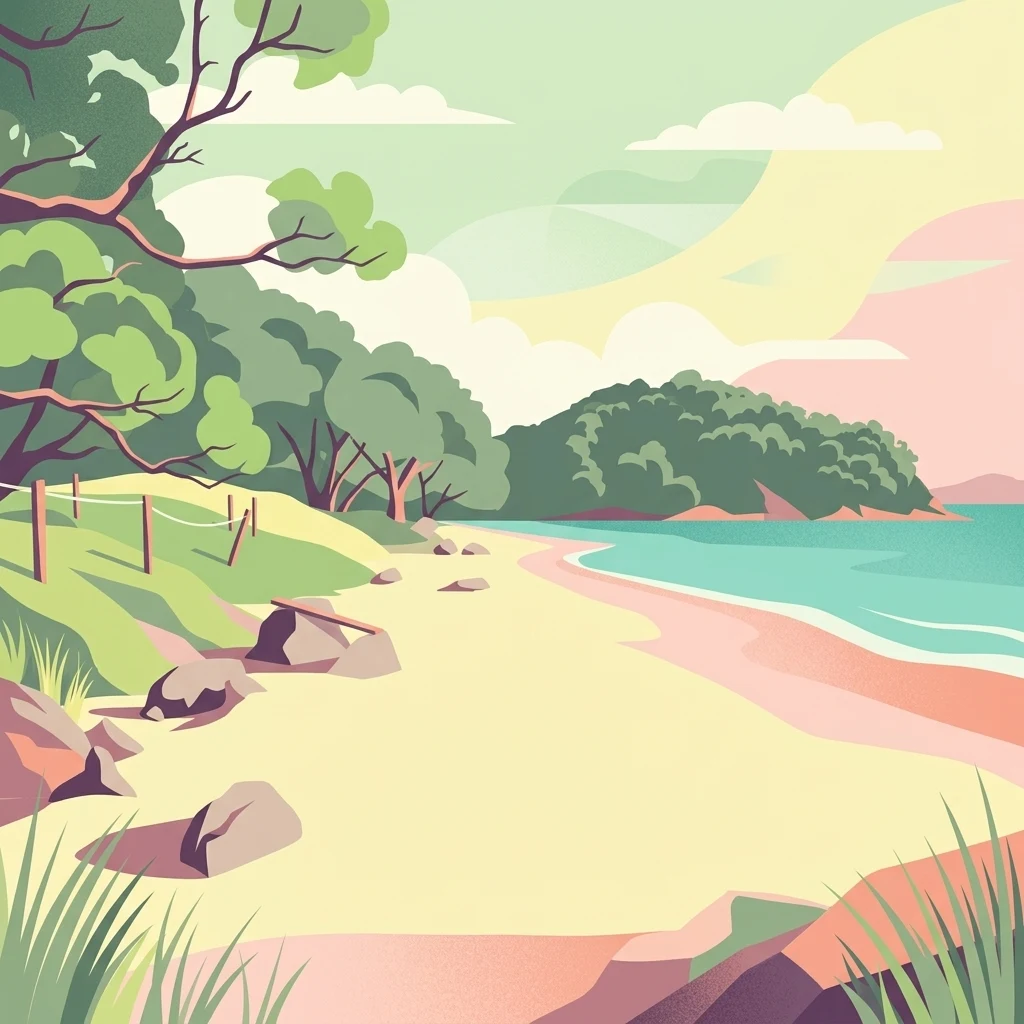
Stylized digital illustration of a sandy beach bordered by native trees and a coastal hillside with a calm sea meeting the shore.

Wenderholm Regional Park

Regional park

Park overview

Structured park overview, official facts, and landscape profile for Wenderholm Regional Park

Wenderholm Regional Park park facts, protected area profile, and essential visitor context

Review the core facts for Wenderholm Regional Park, including designation, size, terrain, visitor scale, habitats, and operating context in one park-focused overview.

About Wenderholm Regional Park

Wenderholm Regional Park sits on the mainland coast just north of the Auckland metropolitan area, occupying a small but unusually varied peninsula where forest, estuary, and beach come together. To the north lies the Puhoi River estuary and to the south the Waiwera River estuary, with the bush-clad Maungatauhoro headland rising between them and a flat sandspit extending toward the sea at the mouth of the Puhoi. This compact setting, only about 135 hectares in total, gives the park a density of contrasting landscapes that is unusual for a regional park so close to a major city.

The park's landform is essentially two-part. The main Maungatauhoro headland is covered in native broadleaf forest, with species such as tawa, kohekohe, taraire, tōtara, nīkau palms, kahikatea, and rimu forming a tiered canopy typical of warm-temperate North Island coastal forest. On the north-facing slopes, stands of kōwhai bloom in yellow through spring, while a 19th-century grove of pōhutukawa, planted and preserved by an early settler, puts on its characteristic red floral display in summer. The lower Puhoi sandspit adds a contrasting tidal and dune environment to the mix.

Wenderholm's identity is also shaped by its place in Auckland's regional park system. It was the first park to be formally established under the Auckland region's regional park network, set aside in 1965 to prevent subdivision and to protect bush that had long been threatened by grazing. Since that time, more than half of the park has functioned as a living ecological experiment in which domestic livestock were excluded and native vegetation allowed to recover, paving the way for the reintroduction of locally extinct bird species. Today the park serves a dual role as a landscape of cultural and ecological significance and as an accessible outdoor area for Auckland residents and visitors, anchored by the Maungatauhoro Te Hikoi walking track and the historic Couldrey House.

Adding a further layer to the park's character is its offshore setting. The coastal waters off Wenderholm are occasionally visited by southern right whales, which may rest and calve in the area, and dolphins are sometimes visible from the shoreline, giving the park a marine dimension that complements its terrestrial and estuarine environments.

Quick facts and research context for Wenderholm Regional Park

Wenderholm Regional Park is a regional park on the east coast of the North Island of New Zealand, situated between the Puhoi River and Waiwera River estuaries north of Auckland.

The park covers about 135 hectares and was established in 1965 as the first regional park in the Auckland Region, following its acquisition by the Auckland Regional Authority under eminent domain. It is managed by Auckland Council and contains both a forested headland and a river-mouth sandspit, along with a historic homestead, a carved pouwhenua, and a native-bird reintroduction area of roughly 60 hectares.

Protection and recognition

Terrestrial protected area classification, management scope, and international recognition details

Wenderholm Regional Park Protection Status and Conservation Recognition

Wenderholm Regional Park features a defined terrestrial protection scope within its documented conservation framework. Official records compile management classifications and administrative designations to support ongoing geographical research.

Protection details

Protection scope
Terrestrial
Transboundary protection
No
Park context

Deeper park guide and search-rich context for Wenderholm Regional Park

Wenderholm Regional Park history, landscape, wildlife, and travel context

Explore Wenderholm Regional Park through its history, landscape character, ecosystems, wildlife, conservation priorities, cultural context, and seasonal travel timing in a structured park guide built for atlas discovery and search intent.

Why Wenderholm Regional Park stands out

Wenderholm Regional Park is best known for its location on a narrow peninsula wedged between two river estuaries, giving it a distinctive combination of coastal, estuarine, and forest habitats within a compact area. It is also recognized as a pioneer of native-bird restoration in the Auckland Region, having fenced off grazing land in 1965 and reintroduced species such as the North Island robin beginning in 1999. The park's identity is further shaped by the 19th-century Wenderholm homestead, now called Couldrey House, and by a long indigenous history that left place names such as Te Akeake, Maungatauhoro, and Mirihau across its landscape.
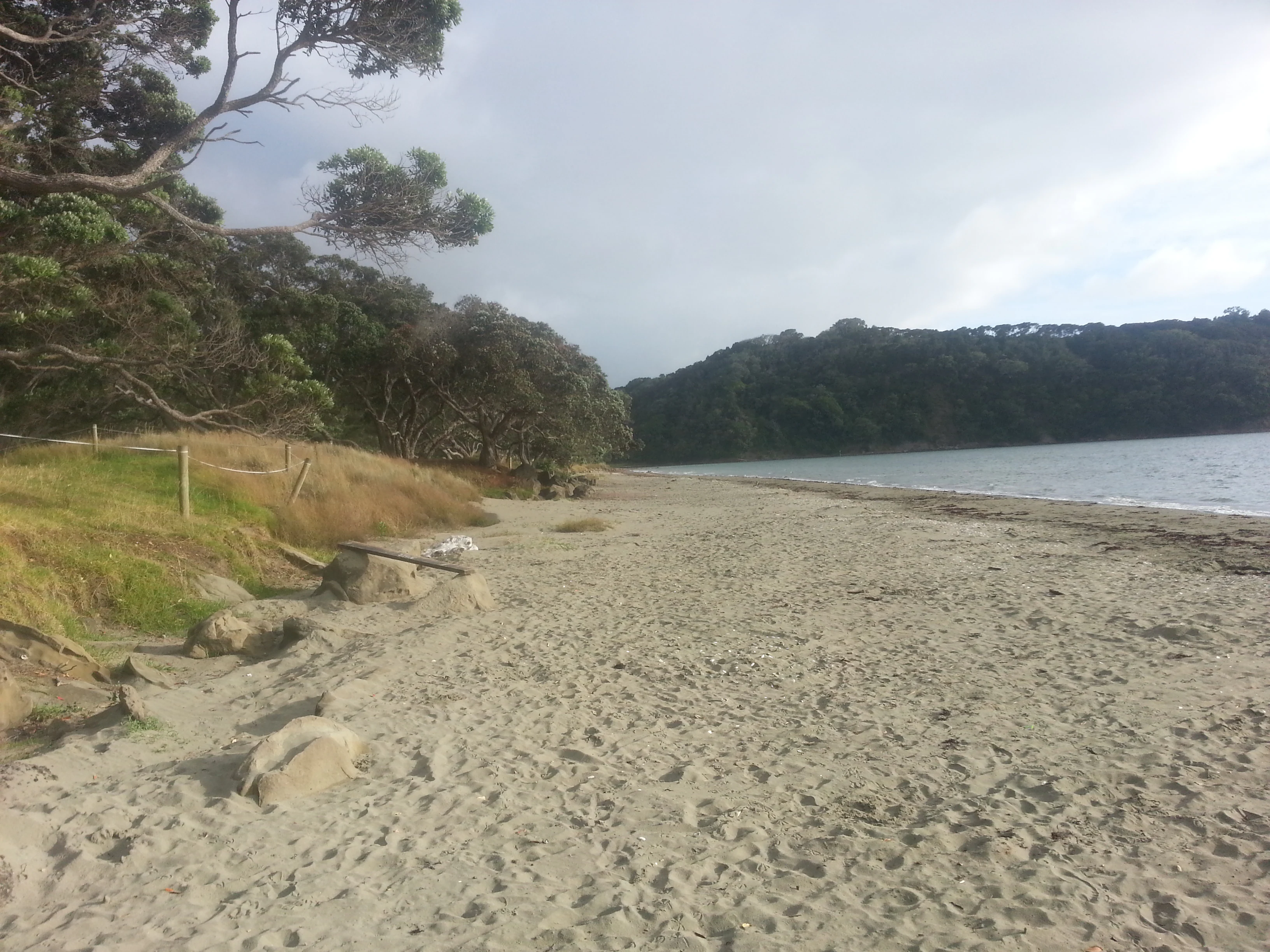
A sandy beach shoreline at Wenderholm Regional Park with native trees along the edge, looking toward a forested hill across the water.
A view along the sandy beach at Wenderholm Regional Park.

Wenderholm Regional Park history and protected-area timeline

Wenderholm has a deep human history that stretches back to the earliest Māori settlement of the Auckland region. Te Kawerau ā Maki related communities occupied the peninsula in locations such as Te Akeake, a kāinga at the mouth of the Puhoi estuary, and Kakaha Pā, a defensive outpost sited on the highest point of the peninsula. Archaeological evidence suggests near-continuous Māori occupation through to the late 19th century, supported by the rich food resources and the river access that the two estuaries provided.

The land later came under European ownership during the colonial period. The Auckland politician and entrepreneur Sir Robert Graham purchased the Maungatauhoro Block from Te Hemara in May 1868 and acquired additional adjoining blocks in 1876 and 1877. He built a homestead in the late 1850s that he named Wenderholm, which is now known as Couldrey House. Graham was an active conservationist for his era, protecting many ancient trees from felling, planting exotic species around his homestead, and preserving a stand of pōhutukawa in the 1880s, some of which had reportedly been given to him by George Grey. After facing financial difficulties, Graham sold the property in 1885, and it passed through several hands with a failed subdivision plan before eventually being repurchased through the Waiwera Company.

In the 1960s, a new subdivision scheme threatened the land again when Herbert William Couldrey sought to carve the area into lifestyle blocks. Although the Rodney County Council approved the proposal, the Auckland Regional Authority appealed and ultimately acquired the property for £185,000 on 31 March 1965 under eminent domain. Following the purchase, the land was formally opened as Wenderholm Regional Park, becoming the first regional park of the Auckland Region and securing the peninsula for ecological restoration and public enjoyment. The protective regime established at that time, most notably the removal of grazing from around 60 hectares of forest, became the foundation of the park's later role in native-bird reintroduction.

Wenderholm Regional Park landscape and geographic character

Wenderholm's landscape is defined by the narrow, almost island-like peninsula on which the park lies. The northern boundary is shaped by the Puhoi River estuary, with the southern boundary marked by the Waiwera River estuary, and the two river mouths act almost like bookends to the forested headland that rises in between. The result is a compact geography in which beach, tidal flat, dune, and forest occur within a short distance of one another.

The dominant landform is the Maungatauhoro headland itself, a rounded, bush-clad rise that forms the spine of the peninsula. The headland supports the densest native vegetation in the park, with mature broadleaf trees forming a layered canopy that gives way to more open coastal vegetation near the cliff edges. Along the northern flanks of the headland, slopes facing the sun support kōwhai trees that flower in spring, while the lower elevation features a long-protected grove of pōhutukawa that bursts into red bloom in summer.

At the opposite end of the park, the Puhoi sandspit forms a flat, low-lying contrast to the forested headland. This sandspit marks the mouth of the Puhoi River and adds an estuarine and dune environment to the park's terrain, complete with tidal channels and a shoreline that frames long views across the Hauraki Gulf. Together, the headland and the sandspit give Wenderholm two distinct halves, joined by walking tracks that link forest, river edge, and beach.

Wenderholm Regional Park ecosystems, habitats, and plant life

The ecological character of Wenderholm is built on the recovery of native coastal forest after more than a century of grazing pressure. Roughly 60 hectares have been protected from livestock since 1965, creating one of the older continuous native regeneration sites in the Auckland region and a benchmark for restoration work in similar coastal settings. The exclusion of grazing allowed understory plants, seedlings, and canopy species to return, gradually restoring a more typical North Island coastal broadleaf forest structure.

In the canopy, the forest features classic warm-temperate species such as tawa, kohekohe, taraire, tōtara, kahikatea, and rimu, with nīkau palms adding a distinctive sub-canopy layer in places. Along the edges of the forest the vegetation changes in response to exposure, sunlight, and salt. Pōhutukawa dominates the headland margins, while kōwhai is prominent on north-facing slopes where its yellow spring blooms stand out against the green of the surrounding bush. The Puhoi sandspit introduces a quite different vegetation pattern, with ground cover adapted to shifting sands, salt spray, and tidal influence.

The estuaries on either side of the park play an equally important ecological role. The Puhoi and Waiwera river mouths feed nutrient-rich tidal water into the bay, supporting invertebrate life and bird feeding, and providing transition zones between fresh and salt water. This combination of regenerating forest, edge habitats on the headland, and estuarine margins at both ends of the peninsula gives Wenderholm a layered ecological profile that is unusually diverse for a park of its size.

Wenderholm Regional Park wildlife and species highlights

Wenderholm's wildlife story is dominated by its native birdlife and by the active program to restore it. Since 1999 the park has been used as a reintroduction site for bird species that had disappeared from the local area, with North Island robins, known scientifically as Petroica longipes ssp. longipes, among the first to be released. The robins established and bred in the regenerating forest, although their juvenile recruitment has not always been sufficient to offset adult losses. Alongside this reintroduction program, common native birds such as tūī, kererū, and New Zealand fantails are regularly seen throughout the park, taking advantage of the recovery of flowering and fruiting trees.

The variety of habitats in a small area supports a wider bird community as well, with forest, edge, and estuarine environments offering different feeding and nesting opportunities. Less welcome from a conservation perspective, Australian kookaburras, originally introduced to Kawau Island in the 19th century, occasionally appear in the park and are noted as part of the local birdlife.

Marine wildlife is part of Wenderholm's character too. The coastal waters off the headland and sandspit are occasionally visited by southern right whales, which may use the area to rest and calve, and dolphins are sometimes visible from the shore. These offshore sightings add a marine dimension to a park whose freshwater estuaries, regenerating forest, and coastal margins also support a wide range of invertebrates and smaller native fauna typical of the Hauraki Gulf coastline.

Wenderholm Regional Park conservation status and protection priorities

Wenderholm holds a special place in regional conservation history because it was the first park in the Auckland Region to be acquired explicitly to protect native bush from subdivision and grazing. The 1965 purchase under eminent domain was decisive, ending decades of pressure from settlement plans and setting aside the peninsula for ecological restoration. From the outset, the defining conservation decision was to remove livestock from around 60 hectares of bush and to let native forest regenerate with minimal interference.

Over time that decision has shaped the park's conservation value in profound ways. The regenerating forest has matured into a refuge for native birdlife and has supported the reintroduction of locally extinct species, beginning with North Island robins in 1999. Because the protected area has functioned as a long-running ecological experiment, the park is often cited as a demonstration of what ungrazed, regenerating coastal forest can achieve over multiple decades in an Auckland setting. The presence of pōhutukawa groves, kōhwai stands, and relatively intact canopy trees adds further conservation significance, particularly for the pollinators, birds, and understory species that depend on them.

Beyond its terrestrial value, the park's two estuarine margins and offshore waters contribute to its conservation role. The Puhoi and Waiwera river mouths are vital transition zones between freshwater and marine environments, and the surrounding Hauraki Gulf coast is part of a broader migratory route for marine species, including southern right whales. Together, the protected forest, the actively restored bird populations, and the relatively intact estuarine and coastal habitats make Wenderholm a small but ecologically significant reserve within the Auckland regional park network.

Wenderholm Regional Park cultural meaning and human context

Wenderholm carries a layered cultural history that begins with long Māori occupation tied to the food resources and river access of the peninsula. Te Kawerau ā Maki related iwi lived in pā and kāinga sites across the headland and estuary flats, including the Te Akeake settlement at the mouth of the Puhoi and the Kakaha Pā defensive outpost on what is now known as Wenderholm Hill. Place names such as Puhoi, Te Akeake, Maungatauhoro, and Mirihau preserve this ancestral association with the land and waterways.

In the colonial era, the park's homestead, originally named Wenderholm and now known as Couldrey House, links the site to the lives of prominent Auckland figures including Sir Robert Graham and later Herbert William Couldrey. Graham's plantings, his preserved grove of pōhutukawa, and his correspondence with Governor George Grey are all part of the cultural heritage embedded in the park's landscape, while the 1965 acquisition under eminent domain represents an important moment in the history of regional conservation policy in the Auckland Region.

Top sights and standout views in Wenderholm Regional Park

Wenderholm Regional Park's standout qualities come from the unusual density of environments packed into its 135 hectares, including native coastal forest, a sheltered sandspit, and two estuarine river mouths at either end. Equally distinctive is its pioneering role in native-bird restoration in the Auckland Region, with decades of ungrazed regeneration culminating in the reintroduction of North Island robins and the ongoing presence of tūī, kererū, and fantails.

The park also stands out for its layered cultural depth, from ancestral Māori occupation to a substantial 19th-century homestead history, and for offering a rare combination of forest walking, estuary views, and occasional sightings of whales and dolphins from the Auckland coast.

Best time to visit Wenderholm Regional Park

Wenderholm can be enjoyed year round, but the seasons strongly shape the character of a visit. In spring, the kōwhai on the north-facing slopes comes into bright yellow bloom and many native forest birds are at their most active, making it a rewarding time for birdwatching and photography. Summer brings the pōhutukawa flowering, especially the 19th-century grove protected by the park's early European owner, which turns the headland margins red and provides a memorable backdrop to coastal walks.

Autumn and winter offer quieter conditions with lush forest color, cooler temperatures, and a more contemplative atmosphere along the Maungatauhoro Te Hikoi track. Offshore sightings of whales and dolphins are possible in any season but tend to be more often reported by visitors during the warmer months and during known whale migration windows along the Hauraki Gulf coast. Visitors who value birdlife, native forest, and seasonal flowering displays will find Wenderholm rewarding across much of the year, while those focused on marine wildlife may wish to plan around broader seasonal patterns in the gulf.

Monthly climate preview

Long-term monthly temperature and precipitation patterns across the Auckland Region

Wenderholm Regional Park Climate Normals and Annual Temperature Rhythm

Representative coordinate measurements reveal the annual temperature and precipitation rhythm recorded at Wenderholm Regional Park between 1991 and 2020. Examining the complete twelve-month climate profile provides detailed insight into long-term averages across the protected area.
Annual mean16 °C
12 °C21 °C
Jan20°
Feb21°
Mar19°
Apr18°
May16°
Jun14°
Jul13°
Aug12°
Sep13°
Oct15°
Nov16°
Dec18°
Warmest month
February

20.6 °C

Coolest month
August

12.5 °C

Wettest month
July

3.5 mm/day

Driest month
January

1.7 mm/day

Park location guide

Geography guide, regional context, and park location map for Wenderholm Regional Park

Wenderholm Regional Park park geography, regions, and map view in New Zealand

Understand where Wenderholm Regional Park sits in New Zealand through a broader geographic reading of the surrounding landscape, nearby location context, and its mapped position within the national park landscape.

How Wenderholm Regional Park fits into New Zealand

New Zealand is an island nation in the southwestern Pacific Ocean comprising two main islands and numerous smaller islands. Located east of Australia across the Tasman Sea, it features varied topography with the Southern Alps running along the South Island and volcanic terrain on the North Island. The country was settled by Maori people between 1280 and 1350, followed by European exploration beginning in 1642, and became a Dominion in 1907 before gaining full independence in 1947.

Wider geography shaping Wenderholm Regional Park in New Zealand

New Zealand lies in the southwestern Pacific Ocean, east of Australia across the Tasman Sea. The country consists of two main islands, the North Island and South Island, plus over 600 smaller islands. The North Island features volcanic plateaus and hills while the South Island is dominated by the Southern Alps mountain range. The country has a long coastline and is surrounded by the Pacific Ocean.

Map view of Wenderholm Regional Park

Use this park location map to pinpoint Wenderholm Regional Park in New Zealand, understand its exact geographic position, and read its mapped placement within the surrounding landscape more clearly.

Pigeon | © OpenStreetMap contributors

Location context for Wenderholm Regional Park

Auckland Region
Recorded earthquake history

Explore the Historical Earthquake Catalogue for Wenderholm Regional Park

Access a detailed record of seismic events associated with the geography of Wenderholm Regional Park. MoriAtlas provides this structured catalogue for those interested in reviewing historical earthquake data relative to the park location and its surrounding coastal environment.

Wenderholm Regional Park Earthquake History

Catalogued events

2 events

Strongest magnitude

Magnitude 4.5

Most recent event

Feb 21, 2007

This history includes earthquakes recorded inside the park or within 50 km of its borders

Explore protected area views, estuarine habitats, and forest terrain across the peninsula.

Wenderholm Regional Park Photos and Landscapes: Visualizing Coastal Scenery

Visual records capture the dense native canopy of the Maungatauhoro headland and the low-lying sandspit cradled between river estuaries. Photographic documentation illustrates the protected coastal environments and diverse habitats defining this regional sanctuary.

A sandy beach shoreline at Wenderholm Regional Park with native trees along the edge, looking toward a forested hill across the water.

Park atlas

Compare nearby coastal reserves, forest habitats, and regional protected areas.

Other Parks Near Wenderholm Regional Park and Surrounding Protected Landscapes

Continue exploring protected areas near Wenderholm Regional Park to compare surrounding coastal forests and estuarine habitats. Broader regional park comparisons reveal patterns across Auckland conservation landscapes.
Regional parkAuckland Region
0.1 km away#1 closest

North

Te Muri Regional Park: Mapped Coastal Peninsula and Estuarine Geography in Auckland

Protected native forest and tidal estuary landscapes

Te Muri Regional Park presents a unique peninsular landscape situated between the Puhoi River and Te Muri O Tarariki Stream in Auckland. This protected area showcases a complex interface between native coastal forest and tidal ecosystems, offering clear mapped boundaries that connect to the wider Hauraki Gulf coastal belt. Explore the topographical transition from sea level estuaries to rolling hill country.

Area
4.44 km²
Established
2010
Relief
Upland
Scope
Terrestrial
A soft watercolor illustration showing the low-lying shape of Motuora Island surrounded by calm water, with a distant hilly coastline in the background.
Nature reserveNorth Island
About 7.5 km away#2 closest

Northeast

Motuora Nature Reserve: Protected Coastal Island Geography and Restoration Map

Predator-free ecological sanctuary in the Hauraki Gulf

Motuora occupies a key position in the Hauraki Gulf, offering a well-mapped look at coastal island restoration in New Zealand. This protected area features a regenerated forest interior and cliff-edged terrain, serving as an important mainland-island site for avian conservation, including kiwi and petrel colonies.

Area
0.8 km²
Established
1965
Relief
Lowland
Climate
Subtropical
A watercolor painting showing a soft, bright landscape with green grasses and wildflowers on both sides of a calm, pale blue body of water, with a green coastline in the distance.
Marine protected areaNew Zealand
29 km away#3 closest

North

Cape Rodney-Okakari Point Marine Reserve: New Zealand Marine Protected Area Geography

Mapped coastal boundaries and marine ecosystem terrain

Delve into the geography of Cape Rodney-Okakari Point Marine Reserve, where protected waters meet a complex interface of greywacke bedrock and sandy substrates. This assessment highlights the ecological transition from exposed rocky headlands to sheltered Whangateau Harbour, illustrating the structural depth of New Zealand's foundational marine site through its diverse invertebrate and fish habitats.

Area
5.5 km²
Established
1975
IUCN
Ia
Visitors
200K annual
A pale, minimalist watercolor painting showing a grassy island or shoreline with a small cluster of trees, set against a quiet body of water and soft, distant rolling hills.
Protected areaAuckland Region
About 36 km away#4 closest

South

Motumānawa / Pollen Island: Protected Marine Reserve and Scientific Landscape in Auckland

A coastal shellbank island refuge within the Waitematā Harbour.

Motumānawa / Pollen Island is an essential protected area near the Rosebank Peninsula, serving as a sanctuary for native bird populations and estuarine vegetation. Its status as both a scientific and marine reserve highlights the importance of small-scale coastal conservation within a major metropolitan harbour landscape in New Zealand.

Established
2006
Relief
Lowland
Scope
Marine
Water
Water-dominated
Regional parkAuckland Region
36 km away#5 closest

North

Te Ārai Regional Park: Mapping Coastal Dune Systems and Protected Geography in Auckland

A protected coastal landscape featuring expansive dune systems and northern headlands.

Te Ārai Regional Park sits as a major protected coastal area on the northern edge of the Auckland Region. Its primary defining feature is an expansive system of sand dunes that anchor a diverse coastal environment. Extending southward toward Poutawa Stream and bordered by the Mangawhai Forest, the park represents a critical geography for endangered species breeding and provides a distinct topographic profile along the North Island coast.

Established
2008
Relief
Lowland
Climate
Subtropical
Access
Easy access
A horizontal watercolor painting of a coastal island landscape with rolling green hills, pale distant mountains, and coastal greenery.
Wildlife reserveAuckland
About 36 km away#6 closest

Southeast

Motuihe Island Wildlife Reserve: Protected Landscapes and Hauraki Gulf Geography

Ecological restoration and coastal island history near Auckland

Motuihe Island represents a significant case study in island conservation, featuring intensive native forest regeneration and successful wildlife reintroduction. The mapped landscape details an elongated island geography defined by coastal beaches, sandstone terrain, and rich archaeological layers, serving as a prominent protected reserve for the Auckland region.

Area
1.79 km²
Relief
Lowland
Climate
Subtropical
Access
Moderate access
Regional parkAuckland Region
38 km away#7 closest

West

Te Rau Pūriri Regional Park: Geography and Protected Land Overview for Auckland Region

Coastal harbour landscape and native forest recovery zones

Te Rau Pūriri Regional Park occupies a strategic position on the South Kaipara Head, serving as a protected corridor between agricultural land and the expansive Kaipara Harbour. The park serves as an atlas-worthy example of ecological transition, featuring sandy bays, eucalyptus stands, and native pūriri forests that provide habitat stability within the wider Auckland coastal geography.

Area
2.49 km²
Established
2006
Relief
Lowland
Climate
Temperate
A soft, pale watercolor illustration depicting a winding stream flowing through a lush, green landscape with gentle hills in the background.
Nature reserveNew Zealand
About 40 km away#8 closest

Southwest

Goldie Bush Scenic Reserve: Protected Forested Landscapes in West Auckland, New Zealand

A study in regenerating bush and Mokoroa Stream topography

Goldie Bush Scenic Reserve encompasses a dense, sheltered catchment valley known for its native forest canopy and the prominent Mokoroa Falls. Once heavily logged, this protected area now serves as an example of ecological restoration in the Waitākere Ranges. The reserve maps a blend of cultural history, including Māori fortification sites, against a backdrop of steep ridges and humid, stream-fed lowland terrain.

Area
2.49 km²
Established
1926
Relief
Upland
Scope
Terrestrial

Common questions about visiting, size, designation, and location context for Wenderholm Regional Park

Wenderholm Regional Park FAQs for park facts, access, geography, and protected area context

Find quick answers about Wenderholm Regional Park, including protected-area facts, park geography, trail and visitor context, and how the park fits into its surrounding country and regional landscape.
MoriAtlas Explorer

Continue Your Protected Areas Search Across the Global Atlas

Deepen your exploration by continuing the structured search for national parks and protected areas worldwide. Utilize the comprehensive filtering capabilities to compare different conservation landscapes and refine your understanding of global park geography. Discover more about the distribution and characteristics of protected natural areas.

Global natural geography