
Mori Atlas logo
Nature reserveWendschotter und Vorsfelder Drömling mit Kötherwiesen

Mapping the hydrological legacy and floodplain geography of this Niedersachsen nature reserve

Wendschotter und Vorsfelder Drömling mit Kötherwiesen: A Protected Lowland Wetland Mosaic

The Wendschotter und Vorsfelder Drömling mit Kötherwiesen nature reserve represents a significant protected landscape in the Niedersachsen region of Germany. This detailed geographic entry examines its flat lowland terrain, characterized by an intricate network of wet meadows, sedge fens, and floodplain corridors shaped by historical Rimpau peat-ditch cultivation. Visitors and researchers can analyze the reserve's unique hydrology and its function as a vital habitat for diverse wetland species within the broader Drömling bog system.

nature reservewet meadowslowland bogAller floodplainpeatlandfens and reedbeds
A flat-style digital illustration showing a straight canal flowing through green meadows lined with trees, with mountains in the background under a pale yellow sun.

Wendschotter und Vorsfelder Drömling mit Kötherwiesen

Nature reserve

Park overview

Structured park overview, official facts, and landscape profile for Wendschotter und Vorsfelder Drömling mit Kötherwiesen

Wendschotter und Vorsfelder Drömling mit Kötherwiesen park facts, protected area profile, and essential visitor context

Review the core facts for Wendschotter und Vorsfelder Drömling mit Kötherwiesen, including designation, size, terrain, visitor scale, habitats, and operating context in one park-focused overview.

About Wendschotter und Vorsfelder Drömling mit Kötherwiesen

Wendschotter und Vorsfelder Drömling mit Kötherwiesen is a medium-sized nature reserve in the Drömling, one of the largest lowland bog landscapes of north-central Germany. Located east of the Wolfsburg districts of Wendschott and Vorsfelde, the reserve protects a representative cross-section of the Lower Saxon portion of the Drömling, including the Kötherwiesen area between the Mittellandkanal and Bundesstraße 188 in the southwest.

The Drömling itself was historically a vast, hard-to-access wetland. From the eighteenth century onwards, systematic land reclamation transformed it into agricultural land, and in the nineteenth century the Rimpau peat-ditch cultivation method left a lasting imprint through its grid of drainage ditches and peat dams. Many of these structural elements still exist, and they continue to influence water flow, land use, and habitat patterns. Today's reserve reflects both that cultural landscape heritage and the ecological recovery made possible through conservation management and large-scale restoration.

At the broadest level, the reserve functions as a key node within the larger Drömling conservation network that spans the state border between Lower Saxony and Saxony-Anhalt. It is fully integrated into the EU Habitats Directive area Drömling and substantially overlaps with the corresponding Birds Directive area, giving it both national and European ecological significance. Its grass-and-water mosaic supports meadow birds, amphibians, bats, otters, beavers, dragonflies, and fish, and it provides connectivity between the other Lower Saxon Drömling reserves (Nördlicher Drömling, Politz und Hegholz, and Südlicher Drömling).

For visitors, the reserve offers a quiet, low-lying wetland landscape crossed by agricultural paths used by walkers and cyclists. While the surrounding area includes the urban edge of Wolfsburg and the Allerpark recreation area with the Allersee to the west, the reserve itself remains a primarily rural, working landscape shaped by extensive mowing and grazing on peat soils subject to regular river flooding. This blend of cultural history, hydrological character, and biodiversity gives the protected area a distinctive identity within the German lowland conservation network.

Quick facts and research context for Wendschotter und Vorsfelder Drömling mit Kötherwiesen

Wendschotter und Vorsfelder Drömling mit Kötherwiesen is a 722-hectare nature reserve (Naturschutzgebiet) designated on 6 August 2020 under the identifier NSG BR 088, located in the city of Wolfsburg in the German state of Lower Saxony. It lies within the Drömling, a former lowland bog region split between Lower Saxony and Saxony-Anhalt, and forms part of the larger trans-regional Drömling habitat network.

The reserve is entirely covered by the FFH-Gebiet Drömling under the EU Habitats Directive, and a large portion is also part of the EU Birds Directive protection area Vogelschutzgebiet Drömling. It borders the neighbouring Lower Saxony nature reserves Nördlicher Drömling, Politz und Hegholz, and Südlicher Drömling, and edges onto the Drömling landscape protection area to the southeast, placing it at the heart of the regional conservation mosaic.

The terrain is extraordinarily flat, between roughly 56 and 59 metres above sea level, with a peat layer 25 to 90 centimetres thick over mineral subsoil. The Mittellandkanal crosses the reserve diagonally, and the Aller and Wipperaller rivers along with a historic ditch network shape the wet-grassland mosaic that defines the landscape.

Protection and recognition

Examine the terrestrial protection scope and historical designation data for this protected area.

Wendschotter und Vorsfelder Drömling mit Kötherwiesen Protection Status and Designation History

Wendschotter und Vorsfelder Drömling mit Kötherwiesen maintains a documented terrestrial protection scope established in the year 2020. Structured records outline the formal designation history and baseline administrative framework for this protected landscape.

Protection details

Protection scope
Terrestrial
Designated year
2020
Transboundary protection
No
Park context

Deeper park guide and search-rich context for Wendschotter und Vorsfelder Drömling mit Kötherwiesen

Wendschotter und Vorsfelder Drömling mit Kötherwiesen history, landscape, wildlife, and travel context

Explore Wendschotter und Vorsfelder Drömling mit Kötherwiesen through its history, landscape character, ecosystems, wildlife, conservation priorities, cultural context, and seasonal travel timing in a structured park guide built for atlas discovery and search intent.

Why Wendschotter und Vorsfelder Drömling mit Kötherwiesen stands out

The reserve is best known for its species-rich, extensively managed wet grassland on lowland peat, including meadows, fens, reedbeds, and tall-herb communities maintained on a high groundwater table. Its distinctive cultural-historical feature is the legacy of nineteenth-century Rimpau peat-ditch cultivation, whose drainage and dam system still structures the landscape and hydrology today. It is also recognised for an unusually diverse fauna for such a flat, intensively modified lowland setting: breeding birds such as common crane, white and black stork, marsh harrier, and corncrake; mammals including Eurasian beaver and European otter; multiple amphibian species including northern crested newt and moor frog; and a wide community of dragonflies, butterflies, and bats tied to its wet habitats and structurally rich floodplain forests.
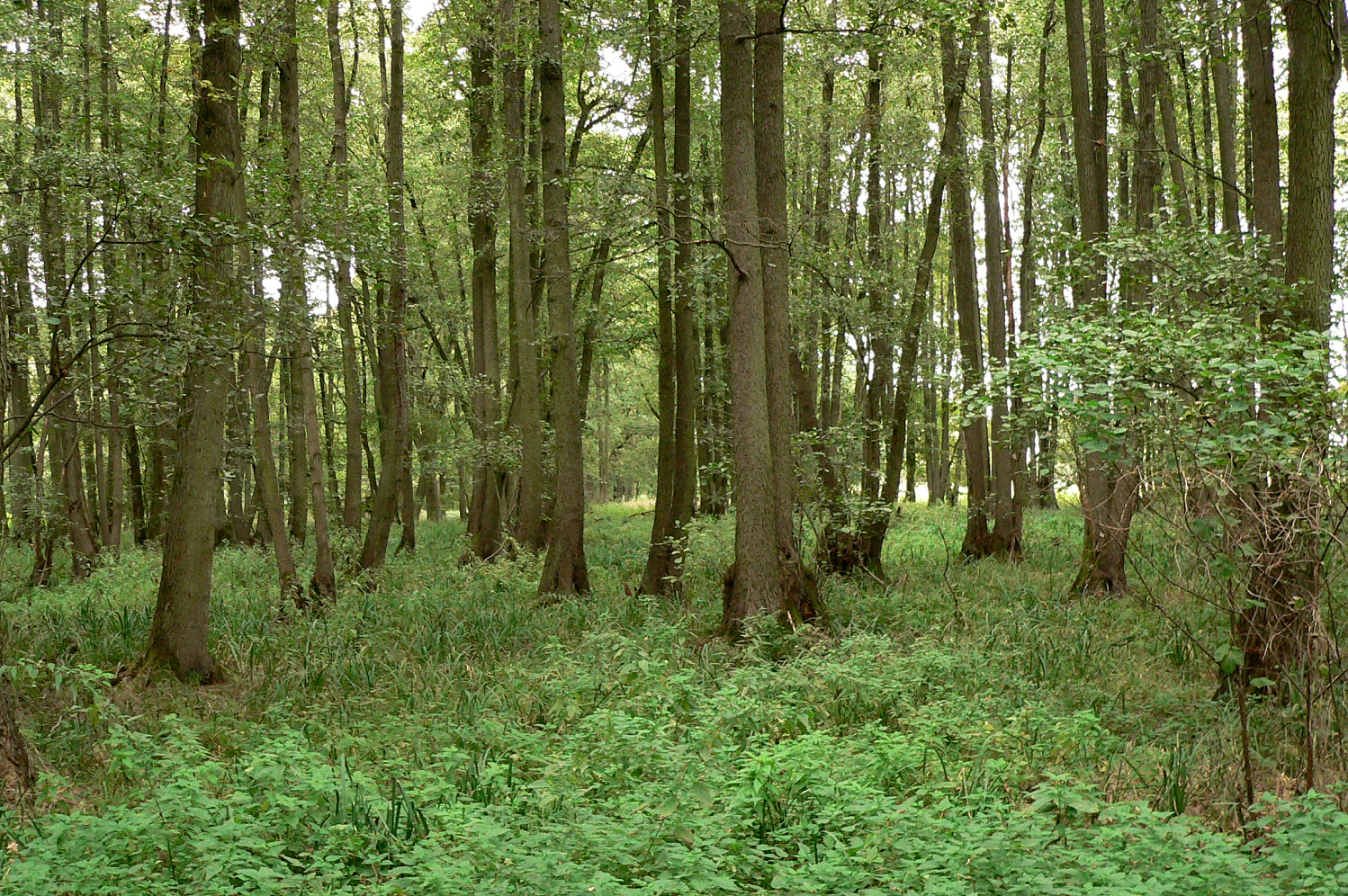
A dense alder swamp forest with tall, straight tree trunks and lush green undergrowth.
Alder swamp forest environment in the Drömling nature reserve.

Wendschotter und Vorsfelder Drömling mit Kötherwiesen history and protected-area timeline

The landscape that the reserve protects has a long history of human modification. Until well into the eighteenth century, the Drömling functioned as an almost impassable lowland bog, and large parts of what is now Lower Saxony farmland were effectively inaccessible. Beginning in that century, successive land-reclamation works transformed the area, and in the nineteenth century the Rimpau peat-ditch cultivation system (Moordammkultur) introduced a characteristic network of drainage ditches, dams, and cultivated strips that still structures much of today's landscape.

Formal nature conservation came relatively late. An earlier, roughly 609-hectare nature reserve called Wendschotter und Vorsfelder Drömling, designated on 2 December 1988, and a section of the broader Landschaftsschutzgebiet Drömling lying north of the Aller within Wolfsburg's city limits, were both fully absorbed into the new, larger reserve declared on 6 August 2020. The new designation expanded and unified protection across this part of the Drömling.

Between November 2002 and October 2012, the area formed part of the major conservation project Naturschutzgroßprojekt Niedersächsischer Drömling, an extensive state programme aimed at restoring wetland hydrology and habitat quality. Additional habitat creation took place between 2006 and 2008, when abandoned fishponds and former tree-nursery plots in the reserve were converted into a near-natural water-body landscape as compensation for the widening of the Mittellandkanal, further strengthening the reserve's wetland character.

Wendschotter und Vorsfelder Drömling mit Kötherwiesen landscape and geographic character

The landscape is extraordinarily flat, lying between approximately 56 and 59 metres above sea level, with no pronounced relief. The overriding feature is a wide, open lowland mosaic of wet meadows, fens, reedbeds, and tall-herb marshland laid out over a peat substrate 25 to 90 centimetres thick. This peat was originally part of a much larger wetland complex that has since been largely drained, and its relict distribution gives the reserve its characteristic structure.

Hydrology defines the scene. The Aller river flows through the lowland, while the Wipperaller runs along parts of the western boundary; both rivers are straightened along their courses within the area. The historic Rimpau-style ditch system, with its peat dams, divides the surface into long cultivated strips that still shape land use and ecological patterns. The Mittellandkanal cuts diagonally across the reserve from southwest to northeast, and the southern Kötherwiesen area, between the canal and Bundesstraße 188, adds a younger mosaic of wet grassland, sedge stands, reeds, and small still waters created through modern compensation measures.
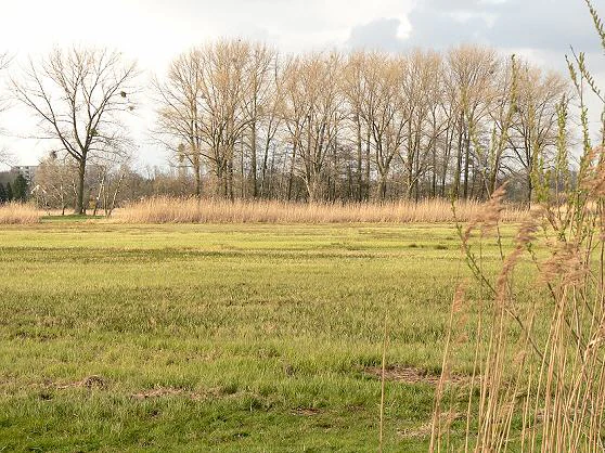
A wide view of a grassy meadow with bare deciduous trees in the background under a cloudy sky.
Grasslands and deciduous trees in the Drömling nature reserve near Vorsfelde.

Wendschotter und Vorsfelder Drömling mit Kötherwiesen ecosystems, habitats, and plant life

Ecologically, the reserve is overwhelmingly a wet-grassland system on lowland peat, maintained through extensive mowing and grazing and kept moist by a high groundwater table. The plant communities range from regularly flooded meadows and pastures to more structurally diverse stands of sedge fens, reedbeds, and tall-herb marshes. Tree cover is limited but ecologically significant, comprising small floodplain and swamp forest patches with high amounts of old and dead wood, which are crucial for bats, woodland amphibians, and many invertebrates.

The flora of the open meadows is unusually rich and includes characteristic species such as meadow alant, yellow and shining meadow-rue, cuckooflower, ragged robin, bulbous buttercup, meadow saxifrage, marsh bird's-foot trefoil, narrow-leaved vetch, marsh clover, and common plants of moist hay meadows such as brown sedge, round-fruited rush, field wood-rush, tall oat-grass, meadow foxtail, and sweet vernal-grass. Tall-herb and reed communities add species like marsh pea and marsh ragwort, while floodplain and swamp forest patches support black alder, ash, downy birch, bird cherry, hazel, pedunculate oak, and both wych and field elm, with a varied herb layer beneath them.

The ditches, ponds, and slow-moving watercourses host a distinct aquatic flora including pillwort, marsh pennywort, frogbit, floating pondweed, several duckweed species, water soldier, yellow water-lily, and white water-lily. These open waters are ecologically important not only for plants but also for amphibians, dragonflies, and fish, linking the terrestrial grassland mosaic with a continuously wet habitat network across the reserve.

Wendschotter und Vorsfelder Drömling mit Kötherwiesen wildlife and species highlights

The reserve supports a remarkably diverse fauna for a drained and heavily modified lowland area, with water and wetland habitats driving much of that diversity. Mammals include Eurasian beaver and European otter, both indicators of functioning wetland systems, while bats are particularly well represented, with species such as common pipistrelle, Nathusius's pipistrelle, serotine, Daubenton's bat, Natterer's bat, and both common and lesser noctules recorded across the reserve's mosaic of woodland, water, and grassland.

Amphibians and reptiles are a major conservation focus. The wet meadows, ditches, and fens harbour great crested newt, garlic toad, moor frog, European tree frog, grass snake, and adder, while the wetter woodland edges host the viviparous lizard. Aquatic habitats support protected fish species such as bitterling, common dace, gudgeon, European weatherfish, and spined loach, along with the freshwater pearl mussel (Bachmuschel), a particularly sensitive indicator of water quality.

The reserve is especially important for birds, both as breeding habitat for wet-grassland specialists and as part of a wider network used by migrating waterbirds. Breeding and regularly occurring species include common crane, white stork, black stork, grey heron, red and black kite, Eurasian hobby, marsh harrier, common quail, grey partridge, corncrake, northern lapwing, common snipe, wryneck, middle, lesser, and European green woodpeckers, golden oriole, common nightingale, meadow pipit, yellow wagtail, sedge and great reed warbler, whinchat, European stonechat, common redstart, lanceolated warbler, Eurasian skylark, common teal, spotted crake, and water rail.

Invertebrate diversity is also significant. The wet grasslands support characteristic butterflies such as the marsh fritillary, eastern large tortoiseshell, and both large and lesser purple emperors, while several grasshopper species, including the marsh grasshopper and large marsh grasshopper, indicate well-preserved moist meadow conditions. Dragonflies are particularly rich around the water bodies, with notable species including the green hawker, the keeled skimmer, and the scarce emerald, highlighting the reserve's strong link to healthy aquatic habitats.

Wendschotter und Vorsfelder Drömling mit Kötherwiesen conservation status and protection priorities

Conservation significance at the reserve operates on several overlapping levels. Nationally, it is protected as a formal nature reserve (Naturschutzgebiet) under Lower Saxon law, with the city of Wolfsburg acting as the responsible lower nature protection authority. Regionally, it forms part of a tightly linked network of Drömling reserves, including Nördlicher Drömling, Politz und Hegholz, and Südlicher Drömling, and shares boundaries with the Drömling landscape protection area, making it a core element of the local conservation mosaic.

At the European level, the reserve is fully within the FFH-Gebiet Drömling under the EU Habitats Directive, ensuring that its habitat types and species are formally assessed and managed under Natura 2000. A large share of its area also falls within the associated Vogelschutzgebiet Drömling under the EU Birds Directive, underlining its importance for protected and migratory bird species. The Kötherwiesen area, in particular, has been developed through compensation measures, including the conversion of former fishponds and tree nurseries into near-natural aquatic habitat as mitigation for the widening of the Mittellandkanal between 2006 and 2008.

The reserve also carries the legacy of the Naturschutzgroßprojekt Niedelsächsischer Drömling (2002-2012), a major state-level conservation programme aimed at wetland restoration. This long-running effort, combined with traditional extensive mowing and grazing on peat soils, supports the hydrological conditions on which species such as crane, marsh harrier, corncrake, common snipe, and numerous meadow plants depend. The protection of beavers and otters, the management of floodplain forests with high old- and dead-wood content, and the maintenance of a high groundwater table are all explicit conservation priorities that go well beyond minimal baseline protection.

Wendschotter und Vorsfelder Drömling mit Kötherwiesen cultural meaning and human context

Culturally, the area is defined by its history as reclaimed wetland and by its continuing integration with the city of Wolfsburg. The nineteenth-century Rimpau peat-ditch cultivation system is not only a hydrological feature but also a cultural landscape signature, embedding the reserve within a long regional tradition of peatland farming and land improvement that shaped much of north-central Germany.

The protected area lies immediately east of the Wolfsburg districts of Wendschott and Vorsfelde, with the southern Kötherwiesen area adjacent to a commercial zone and to the Allerpark, Wolfsburg's main urban recreational area with the Allersee lake. This positioning gives the reserve a dual character as both a piece of protected rural landscape and part of a city-region's green infrastructure, with agricultural paths linking the reserve to the urban edge for walking and cycling.

Top sights and standout views in Wendschotter und Vorsfelder Drömling mit Kötherwiesen

Standout features of the reserve include its unusually species-rich wet meadows and fens on lowland peat, sustained by a high water table and the legacy of Rimpau peat-ditch cultivation. The combination of floodplain and swamp forest remnants, ditch networks, the Aller and Wipperaller river corridors, and the Kötherwiesen mosaic of young grasslands and still waters gives the area a layered habitat structure uncommon in such a low-lying and formerly drained landscape.

The reserve is also notable for its role as a stepping stone within the larger Drömling conservation area, its full integration into both the EU Habitats Directive and EU Birds Directive site Drömling, and the presence of charismatic wetland species such as common crane, white and black stork, Eurasian beaver, and European otter, all of which signal a functioning wetland ecosystem at a meaningful regional scale.

Best time to visit Wendschotter und Vorsfelder Drömling mit Kötherwiesen

The reserve has a strongly seasonal character tied to water levels, meadow management, and bird activity. Spring and early summer are typically the most rewarding period for observing breeding birds such as cranes, lapwings, snipe, and various warblers in the wet meadows and reedbeds, while amphibians are most active around the ditches and ponds during warm, damp evenings in spring and early summer.

Late spring through midsummer is also when the species-rich meadows are in full bloom, offering the richest experience of the botanical mosaic. In late autumn and winter, higher water levels and periodic flooding of the Aller and Wipperaller floodplains can transform parts of the grassland into open water, attracting waterfowl and changing the visual character of the landscape considerably. Throughout the year, the flat, open terrain and agricultural paths make walking and cycling visits pleasant whenever conditions are not too wet, though flooded sections should be expected in the wetter months.


Monthly climate preview

Long-term temperature and precipitation averages across representative coordinates in Niedersachsen

Wendschotter und Vorsfelder Drömling mit Kötherwiesen Climate and Monthly Weather Patterns

Representative coordinate records outline sustained temperature ranges from subzero winter lows to warm summer maximums alongside steady daily precipitation normals. Reviewing complete monthly measurements provides deeper context regarding annual atmospheric rhythms and localized baseline data.
Annual mean9 °C
0 °C19 °C
Jan
Feb
Mar
Apr
May13°
Jun17°
Jul19°
Aug18°
Sep14°
Oct
Nov
Dec
Warmest month
July

18.6 °C

Coolest month
January

0.2 °C

Wettest month
July

2.6 mm/day

Driest month
April

1.4 mm/day

Park location guide

Geography guide, regional context, and park location map for Wendschotter und Vorsfelder Drömling mit Kötherwiesen

Wendschotter und Vorsfelder Drömling mit Kötherwiesen park geography, regions, and map view in Germany

Understand where Wendschotter und Vorsfelder Drömling mit Kötherwiesen sits in Germany through a broader geographic reading of the surrounding landscape, nearby location context, and its mapped position within the national park landscape.

How Wendschotter und Vorsfelder Drömling mit Kötherwiesen fits into Germany

Germany is a federal republic in Western and Central Europe with a population of over 83 million across sixteen constituent states. It is Europe's largest economy by nominal GDP and a major global exporter and importer. The capital is Berlin, and the country borders Denmark, Poland, Czech Republic, Austria, Switzerland, France, Luxembourg, Belgium, and the Netherlands.

Wider geography shaping Wendschotter und Vorsfelder Drömling mit Kötherwiesen in Germany

Germany is located in Western and Central Europe, spanning 357,022 km². It borders Denmark to the north, Poland and the Czech Republic to the east, Austria and Switzerland to the south, and France, Luxembourg, Belgium, and the Netherlands to the west. The country has coastlines on the Baltic Sea and North Sea to the north, with the Alps located in the southern region.

Map view of Wendschotter und Vorsfelder Drömling mit Kötherwiesen

Use this park location map to pinpoint Wendschotter und Vorsfelder Drömling mit Kötherwiesen in Germany, understand its exact geographic position, and read its mapped placement within the surrounding landscape more clearly.

Pigeon | © OpenStreetMap contributors

Location context for Wendschotter und Vorsfelder Drömling mit Kötherwiesen

Niedersachsen

Visual reference guide to wet meadows, peatland terrain, and lowland river habitats

Wendschotter und Vorsfelder Drömling mit Kötherwiesen Photos and Protected Landscape Scenery

Photographic records illustrate the flat lowland topography, extensive wet meadows, and intricate ditch networks of Wendschotter und Vorsfelder Drömling mit Kötherwiesen. Visual documentation captures the protected terrain and specialized wetland habitats that characterize the northern German nature reserve.

A dense alder swamp forest with tall, straight tree trunks and lush green undergrowth.

A narrow canal stretches into the distance through green meadows under a clear sky, with a wooden bridge railing in the foreground and cattle grazing in the field on the right.

A wide view of a grassy meadow with bare deciduous trees in the background under a cloudy sky.

Park atlas

Compare surrounding wetland reserves and regional protected terrain across north-central Germany.

Parks near Wendschotter und Vorsfelder Drömling mit Kötherwiesen and Connected Protected Landscapes

Browsing other protected areas near Wendschotter und Vorsfelder Drömling mit Kötherwiesen reveals broader lowland bog ecosystems and connected river floodplains. Evaluating adjacent regional reserves provides valuable context for understanding wetland conservation patterns throughout Lower Saxony.
Nature reserveLandkreis Helmstedt
About 3.4 km away#1 closest

East

Südlicher Drömling: Protected Floodplain Landscapes in Landkreis Helmstedt

Wetland nature reserve and alluvial forest geography

Südlicher Drömling represents a critical protected wetland area defined by the Aller river floodplain. The landscape provides a study in successional dynamics, featuring old-growth alluvial forests, species-rich wet meadows, and temporary open-water pools during seasonal flooding periods. It stands as an important regional anchor for migratory bird species and floodplain restoration within the broader Drömling basin.

Area
6.02 km²
Established
2018
Nature reserveLower Saxony
About 11 km away#2 closest

Northwest

Vogelmoor Nature Reserve: Geographic Map and Protected Wetland Landscape in Lower Saxony

Birch bog forests, peat ponds, and rare mire habitats

Vogelmoor offers a deep look into the glacial topography of northern Germany. As a core protected area within the Gifhorn district, this site features a diverse assembly of sphagnum-rich forest, floating mats, and open heath. The reserve stands as a critical example of landscape restoration within a heavily agricultural region, providing essential refuge for wetland bird species and specialized bog vegetation.

Area
1.335 km²
Established
1974
IUCN
IV
Watercolor illustration of a peaceful landscape featuring distant rolling hills, clusters of trees on the right, and a river or stream winding through a grassy plain against a pale background.
Protected landscapeLower Saxony
About 18 km away#3 closest

South

Dorm Protected Landscape: Geological Ridge and Forested Geography in Lower Saxony

Mapping the natural terrain and forest ecosystems of the East Brunswick hill country

Defined by its narrow anticline structure and diverse woodland mosaics, the Dorm stands as a vital protected area in Lower Saxony. This overview examines the ridge's geological composition, including its Triassic sandstone formations, saline habitats, and significant doline pools that characterize this prominent East Brunswick landmark.

Area
6.89 km²
Established
2020
Relief
Upland
Climate
Temperate
Protected landscapeLower Saxony
About 26 km away#4 closest

Southwest

Weddeler Teich Protected Landscape: Wetland Geography and Regional Map Context

A mapped nature reserve in the Lower Saxony lowlands

Weddeler Teich is a protected landscape in Lower Saxony characterized by its shallow, nutrient-rich basin and extensive reed vegetation. This wetland reserve acts as a critical refuge for bird species, standing out as a verdant marshy pocket within the wider cultivated agricultural plains east of Braunschweig.

Area
0.2 km²
Established
1981
Relief
Lowland
Climate
Temperate
Nature reserveLower Saxony
About 27 km away#5 closest

West

Viehmoor Nature Reserve: A Detailed Atlas of Wetland and Dune Landscapes in Lower Saxony

Protected lowlands, inland dunes, and riparian habitats

Viehmoor is a distinct 302-hectare protected area in Lower Saxony defined by its glacial history and diverse habitat transitions. The site features an inland dune ridge encircling a groundwater-fed lowland mire, alongside varied aquatic environments including reed-fringed fishponds and peat-cutting pools that provide vital breeding grounds for regional bird populations.

Area
3.02 km²
Established
1979
IUCN
IV
Nature reserveLower Saxony
About 43 km away#6 closest

North

Zwergbirkenmoor bei Schafwedel: Protected Bog and Birch Woodland Geography

A rare peatland remnant in the Lower Saxony moorland network.

Zwergbirkenmoor bei Schafwedel is a designated nature reserve that safeguards a small but ecologically significant raised bog remnant. Set amidst the unique salt-dome subsidence landscape of the Lüneburg Heath, the reserve serves as a critical site for studying rare northern birch bog communities and the interaction between groundwater systems and post-salt-dome terrain.

Area
0.027 km²
Established
1950
IUCN
IV
Relief
Lowland
Nature reserveLower Saxony
About 44 km away#7 closest

West

Wendesser Moor Nature Reserve: Mapped Wetland Geography and Protected Landscape Context in Lower Saxony

Exploring the peatland mosaic and marsh bird habitats of the Peine district

Wendesser Moor is a significant 63-hectare nature reserve in Lower Saxony, defined by its rare concentration of fen habitats, alder carr, and open peat pools. As a core component of a wider landscape protection zone, it provides essential refuge for threatened bird species. The reserve functions as a critical node in the local watershed, illustrating how small-scale protected peatlands maintain biodiversity in agricultural lowlands.

Area
0.632 km²
Established
1973
IUCN
IV
Relief
Lowland
Nature reserveSalzgitter
About 54 km away#8 closest

Southwest

Tagebau Haverlahwiese Nature Reserve: Geography and Protected Area Mapping in Salzgitter

Mapping restored post-industrial landscapes and habitat mosaics.

This protected area in Salzgitter showcases the natural recovery of former ironstone mining lands. Users can examine the spatial arrangement of the 15-hectare mining lake, extensive reedbeds, and dry calcareous grassland slopes. The site remains a vital example of landscape conservation, illustrating how engineered topography provides new niches for amphibians and salt-tolerant plant communities across the Lichtenberge ridge.

Area
2.06 km²
Established
2016
Relief
Upland
Climate
Temperate

Common questions about visiting, size, designation, and location context for Wendschotter und Vorsfelder Drömling mit Kötherwiesen

Wendschotter und Vorsfelder Drömling mit Kötherwiesen FAQs for park facts, access, geography, and protected area context

Find quick answers about Wendschotter und Vorsfelder Drömling mit Kötherwiesen, including protected-area facts, park geography, trail and visitor context, and how the park fits into its surrounding country and regional landscape.
MoriAtlas Explorer

Continue Your Protected Areas Search Across the Global Atlas

Deepen your exploration by continuing the structured search for national parks and protected areas worldwide. Utilize the comprehensive filtering capabilities to compare different conservation landscapes and refine your understanding of global park geography. Discover more about the distribution and characteristics of protected natural areas.

Global natural geography