

Mori Atlas logo
Marine protected areaWestern Eyre Marine Park

Understanding the offshore continental shelf and zoned conservation geography of southern Australia

Western Eyre Marine Park: Mapping the Protected Marine Landscapes of the Great Australian Bight

Western Eyre Marine Park encompasses a vast expanse of open ocean across the Great Australian Bight, forming a critical segment of the South-West Marine Park Network. This protected area features complex underwater terrain defined by the southern Australian continental shelf and slope. Through its tiered management zones, the reserve maintains essential cool-water marine ecosystems far offshore from the Eyre Peninsula.

marine parkCommonwealth watersGreat Australian Bightoffshore oceancontinental shelfmarine protected area

Western Eyre Marine Park

Marine protected area

Park overview

Structured park overview, official facts, and landscape profile for Western Eyre Marine Park

Western Eyre Marine Park park facts, protected area profile, and essential visitor context

Review the core facts for Western Eyre Marine Park, including designation, size, terrain, visitor scale, habitats, and operating context in one park-focused overview.

About Western Eyre Marine Park

Western Eyre Marine Park is a Commonwealth marine protected area situated in the Great Australian Bight, in offshore waters south of South Australia. It lies beyond the coastal waters of the Eyre Peninsula, occupying a broad area of ocean that reflects the vastness of the Bight itself. The park forms part of Australia's national marine park system, which is overseen by the Director of National Parks, and it works alongside other reserves in the region as part of the South-West Marine Park Network, a coordinated grouping of marine parks in Australia's south-west waters.

The park takes its name from its position relative to the western side of the Eyre region, the large South Australian peninsula that defines much of the landward side of the Bight. While the nearest recognised onshore community is Streaky Bay, the park itself is an exclusively marine environment, with no land within its boundaries. This offshore character means that the park protects open ocean and shelf waters rather than coastal or estuarine habitats, distinguishing it from many smaller, nearshore marine reserves.

Protected under formal Australian marine park legislation and officially gazetted at the end of 2012, the reserve is structured into multiple management zones, allowing different approaches to conservation and use across its waters. The zones range from areas affording the highest level of protection to those that permit regulated activities, reflecting Australia's broader marine park model in which multiple categories coexist within a single large park boundary. The presence of a dedicated marine national park zone within the reserve gives the park a strong conservation focus, while the additional zones extend its reach across a much larger ocean area.

The significance of Western Eyre Marine Park extends beyond its own boundaries. By sitting adjacent to other marine parks in the South-West network, including the Great Australian Bight Marine Park further west, it helps form a connected chain of protection along one of the more remote and ecologically important ocean regions in Australia. Together, these reserves represent a substantial commitment to safeguarding the marine environment of southern Australia at a regional scale.

Quick facts and research context for Western Eyre Marine Park

Western Eyre Marine Park lies in Commonwealth waters of the Great Australian Bight, south of South Australia, and is one of the large offshore marine parks that make up the South-West Marine Park Network. The reserve was gazetted in late 2012 and is managed at the national level by the Director of National Parks, reflecting its status as a Commonwealth marine reserve rather than a state-managed coastal area. The park combines a marine national park zone, designated under a strict IUCN category, with additional zones that allow differing levels of activity, providing both conservation protection and a framework for managing use of the surrounding ocean.

Protection and recognition

Examine the documented marine protection status and official designation scope.

Western Eyre Marine Park Protection Status and Conservation Recognition

Western Eyre Marine Park maintains a defined marine protection scope within its designated conservation framework. Review the recorded management parameters and official administrative classifications associated with this protected area.

Protection details

Protection scope
Marine
Transboundary protection
No
Core area
17,439 km²
Park context

Deeper park guide and search-rich context for Western Eyre Marine Park

Western Eyre Marine Park history, landscape, wildlife, and travel context

Explore Western Eyre Marine Park through its history, landscape character, ecosystems, wildlife, conservation priorities, cultural context, and seasonal travel timing in a structured park guide built for atlas discovery and search intent.

Why Western Eyre Marine Park stands out

Western Eyre Marine Park is best known for its role in protecting an extensive section of ocean in the Great Australian Bight, an offshore environment shaped by the southern Australian continental shelf and cool, nutrient-rich waters that support a wide range of marine life. The park's large area and its division into multiple zones with different conservation objectives make it a notable example of Australia's approach to balancing protection with managed use in Commonwealth waters. Its place within the South-West Marine Park Network also gives it regional significance as part of a coordinated attempt to safeguard connected ocean ecosystems along southern Australia.

Western Eyre Marine Park history and protected-area timeline

Western Eyre Marine Park was established as part of a broader Australian effort to create a national network of marine protected areas in Commonwealth waters. It was gazetted in November 2012 and officially came into existence on 8 December 2012 under the Commonwealth marine reserves framework. The park was initially designated as the Western Eyre Commonwealth Marine Reserve, reflecting its status as a Commonwealth-managed marine protected area rather than a state coastal reserve, before later being referred to under its current marine park title.

Its creation was part of the development of the South-West Marine Park Network, a regional grouping of marine parks that brought multiple reserves into coordinated management across the south-west of Australia. The park's design, with a marine national park zone embedded inside a larger area of differently zoned waters, mirrored the national approach of combining strict protection with zones that allow a regulated level of use.

The park has continued to be managed by the Director of National Parks, the Australian Government position responsible for Commonwealth reserves. While the park is far less prominent in public discussion than some terrestrial national parks, its establishment marked an important step in formal protection for a large area of the Great Australian Bight, adding to a growing system of offshore marine reserves that together span much of southern Australian ocean.

Western Eyre Marine Park landscape and geographic character

The landscape of Western Eyre Marine Park is defined entirely by ocean. There are no islands, reefs breaking the surface, or coastal landforms within its boundaries; the reserve is made up of open water extending across a broad swath of the Great Australian Bight. The seafloor beneath these waters includes the continental shelf and the slope descending from it, shaping underwater terrain that influences the movement of water and the distribution of marine life across the park.

Offshore waters of this kind in the Great Australian Bight are known for their cool, generally wave-exposed character, with a deep, open horizon and a notable absence of shallow bays or sheltered inlets. Although the park is far from shore, the seafloor influences above-water conditions through currents and upwelling, supporting the productivity on which the Bight's marine ecosystems depend.

The visual experience of the park, for anyone approaching or passing through it, is one of wide open ocean. There are no landmarks, headlands, or elevated terrain to break the seascape. This sense of openness is itself a defining feature of the reserve: a landscape of scale and distance, where the only visible land is distant, beyond the park boundary.

Western Eyre Marine Park ecosystems, habitats, and plant life

The marine environment of the Great Australian Bight is shaped by cool waters and nutrient cycling along the southern continental shelf, and Western Eyre Marine Park protects a substantial portion of these waters. The park's marine national park zone targets areas considered of higher conservation value, while the broader multiple use and special purpose zones extend management across surrounding waters that share similar ocean conditions but are considered suitable for regulated use.

The ocean environments within the park include pelagic, open-water habitats as well as seafloor habitats associated with the continental shelf and slope. These environments together support a marine food web that begins with phytoplankton and zooplankton fuelled by nutrient upwelling, and extends through small pelagic species to larger predators at higher levels of the food chain. By placing parts of this ocean under formal protection, the park contributes to maintaining the ecological processes that sustain productivity in the Bight.

Although most of the park's ecology lies beneath the waves and is not visible from the surface, its importance is linked to the wider ecological role of the Great Australian Bight as a southern Australian ocean ecosystem. Protection of water column and seabed habitats here complements similar conservation efforts elsewhere in the South-West Marine Park Network.

Western Eyre Marine Park wildlife and species highlights

The waters of the Great Australian Bight support a wide array of marine life, and Western Eyre Marine Park contributes to safeguarding habitat for many of the species that depend on this region. The Bight is internationally recognised for its marine mammal populations, with southern right whales historically using its coastal and shelf waters and other cetacean species occurring offshore. The broader southern Australian ocean also supports seals, sharks, pelagic fishes, and seabirds that range across many hundreds of kilometres of sea.

Marine wildlife in the Bight depends on the productivity of the waters themselves, which is supported by cool ocean conditions and seasonal upwelling along the shelf edge. This productivity sustains both resident species and those that move through the region seasonally or as part of larger migrations. By protecting an extensive area of ocean habitat, the park helps provide space for species to feed, breed, and travel through waters that are otherwise subject to various human activities.

The presence of seabirds is also a notable feature of these waters, with several species ranging far offshore and using the open ocean for feeding and movement. Together with whales, sharks, and other pelagic animals, they form part of the wider community of marine life that the park's conservation framework is designed to support.

Western Eyre Marine Park conservation status and protection priorities

Western Eyre Marine Park was established with a clearly conservation-oriented purpose, as part of a formalised Commonwealth marine reserves system that places parts of Australia's offshore ocean under legal protection. Its design, which includes an IUCN Category II marine national park zone surrounded by other specially designated zones, reflects a deliberately structured approach to conservation, recognising that different parts of an offshore marine area may need different levels of protection depending on their ecological character and the activities that take place there.

The park contributes to conservation at a regional scale by forming part of the South-West Marine Park Network. This network approach allows individual marine parks to function not just as isolated protected patches but as components of a wider conservation system, helping maintain ecological processes across an extensive stretch of southern Australian ocean. In this broader context, Western Eyre Marine Park helps protect habitats, species, and ocean processes that are otherwise difficult to safeguard through coastal reserves alone.

The marine national park zone, the most strictly protected part of the park, is designed to limit activities that could damage the habitat or the species that depend on it. The multiple use and special purpose zones, while allowing a broader range of activities under regulation, still operate within the Commonwealth marine park framework, which is fundamentally aimed at maintaining marine environmental values over the long term. Together, these zones demonstrate how large offshore areas can be conserved at a meaningful scale in Australian waters.

Western Eyre Marine Park cultural meaning and human context

The waters of the Great Australian Bight have long cultural significance for Aboriginal peoples of southern Australia, particularly those whose traditional Country includes coastal stretches along the southern coastline. The ocean itself, including remote offshore areas, is part of this broader cultural landscape, even where direct human contact is limited. While the park is defined as a marine protected area rather than a cultural site, it sits within a region whose identity and meaning extend well beyond its formal conservation designation.

For coastal communities of the Eyre Peninsula and wider South Australia, the Bight has also come to hold a distinct regional significance, both as a working maritime environment and as a defining feature of the local geography. Western Eyre Marine Park, though administered at the Commonwealth level, exists in this wider context of regional identity, where the ocean is part of how South Australians relate to the southern edge of the continent.

Top sights and standout views in Western Eyre Marine Park

Among Western Eyre Marine Park's most notable features is its sheer scale, covering thousands of square kilometres of open ocean in the Great Australian Bight, south of Australia's southern coastline. Its zoning design, combining a marine national park zone with multiple use and special purpose zones, is itself a defining characteristic, demonstrating how Australia structures large offshore marine reserves into different levels of protection.

Equally important is the park's role within the South-West Marine Park Network, situating it alongside neighbouring marine parks to form one of the more substantial systems of offshore marine conservation in Australian waters. Its position east of the Great Australian Bight Marine Park extends a continuous approach to marine protection across a vast stretch of the Bight, making the park a significant part of how Australia safeguards the marine environment of its southern ocean region.

Best time to visit Western Eyre Marine Park

As an offshore marine park with no land access, Western Eyre Marine Park is not visited in a conventional sense, and information about specific visitor seasons or onshore recreational use is limited. For any ocean-based activity that might take place in or near the park, conditions in the Great Australian Bight are generally calmer during the warmer, drier months of late spring through autumn, when southern Australian sea conditions tend to be more settled, while winter brings stronger winds and rougher seas typical of this exposed stretch of coast.

Wildlife interest across the Bight follows seasonal patterns, with marine mammal and seabird activity varying through the year. Most general engagement with the park, however, comes not from direct visits but through broader awareness of the Bight's ocean environment, including seasonal whale and seabird viewing from coastal vantage points far outside the park itself.
Monthly climate preview

Long-term monthly temperature and precipitation averages derived from representative regional data

Western Eyre Marine Park Climate Normals and Annual Temperature Rhythm

Western Eyre Marine Park exhibits a measured annual temperature and precipitation rhythm spanning long-term monthly averages from 1991 to 2020. Examining the complete twelve-month climatology profile provides detailed insight into representative coordinate measurements across the protected marine area.
Annual mean16 °C
14 °C19 °C
Jan19°
Feb19°
Mar18°
Apr18°
May17°
Jun15°
Jul15°
Aug14°
Sep15°
Oct15°
Nov16°
Dec17°
Warmest month
February

18.9 °C

Coolest month
August

14.2 °C

Wettest month
July

1.7 mm/day

Driest month
February

0.5 mm/day

Park location guide

Geography guide, regional context, and park location map for Western Eyre Marine Park

Western Eyre Marine Park park geography, regions, and map view in Australia

Understand where Western Eyre Marine Park sits in Australia through a broader geographic reading of the surrounding landscape, nearby location context, and its mapped position within the national park landscape.

How Western Eyre Marine Park fits into Australia

Australia is a constitutional monarchy and federal parliamentary democracy comprising six states and ten territories. With a population of nearly 28 million, it is one of the world's most urbanised countries, with most people concentrated on the eastern seaboard. The country has a high Human Development Index and is known for its cultural diversity, ancient Aboriginal heritage, and unique wildlife.

Wider geography shaping Western Eyre Marine Park in Australia

Australia occupies the entire Australian continent, the island of Tasmania, and numerous smaller islands. It is the world's flattest and driest inhabited continent, featuring vast deserts in the interior (the Outback), tropical rainforests along the eastern coast, and a coastline bordering the Indian and Pacific Oceans.

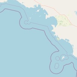
Map view of Western Eyre Marine Park

Use this park location map to pinpoint Western Eyre Marine Park in Australia, understand its exact geographic position, and read its mapped placement within the surrounding landscape more clearly.

Pigeon | © OpenStreetMap contributors

Location context for Western Eyre Marine Park

South Australia
Park atlas

Compare adjacent marine reserves and surrounding southern ocean protected landscapes.

Parks Near Western Eyre Marine Park and Connected Regional Protected Areas

Browse other marine parks located near Western Eyre Marine Park across the Great Australian Bight. Expanding the geographic scope reveals connected conservation zones along the southern continental shelf.
Nature reserveSouth Australia
About 61 km away#1 closest

Southeast

Greenly Island Conservation Park: Geography and Protected Nature Reserve Map

Island protected area off the South Australian Eyre Peninsula.

This offshore nature reserve preserves an exposed, rocky island environment in the Southern Ocean. As a protected area for marine mammal haul-out sites, it provides a unique look at isolated coastal terrain and strict conservation management along the western shoreline of South Australia.

Area
1.68 km²
Established
1967
IUCN
Ia
Relief
Lowland
Nature reserveSouth Australia
About 76 km away#2 closest

Northeast

Cap Island Conservation Park: Nature Reserve and Offshore Marine Habitat in South Australia

Coastal granite island and protected seabird breeding landscape.

Situated off the coast of the Eyre Peninsula, Cap Island Conservation Park is a protected nature reserve serving as a critical sanctuary for pinnipeds and nesting seabirds. Its unique geological profile, featuring a granite base and calcarenite cap, creates a rugged offshore environment shaped by marine erosion and salt-tolerant vegetation. The reserve highlights the significance of isolated island ecosystems within the broader geography of South Australia.

Area
0.09 km²
Established
1967
IUCN
Ia
Relief
Lowland
National parkSouth Australia
About 78 km away#3 closest

Southeast

Coffin Bay National Park: Protected Landscape and Geographic Context in South Australia

Explore the mapped boundaries and regional geography of this national park.

Coffin Bay National Park presents a distinct protected landscape within South Australia, offering a valuable point of entry for geographic discovery. This page details the park's national park designation and its mapped territory, crucial for understanding its role in Australia's atlas of natural areas. Delve into the park's specific geographic context and the outlines of its protected lands, providing a clear picture of its landscape within the state's broader terrain.

Area
309.76 km²
Established
1982
IUCN
II
Relief
Lowland
Wildlife reserveSouth Australia
About 126 km away#4 closest

Northeast

Dakalanta Sanctuary: A Private Wildlife Reserve on the Northern Eyre Peninsula

Mapped regional geography and conservation habitat profiles

Dakalanta Sanctuary provides a significant example of private land conservation in South Australia. Covering 130 square kilometres of low hills and stabilized dunes, this reserve focuses on restoring native vegetation after past pastoral use. The area is vital for safeguarding semi-arid habitats like mallee woodlands, playing an active role in regional biodiversity protection and habitat connectivity.

Area
130 km²
Established
2002
Relief
Upland
Access
Access unknown
Protected areaSouth Australia
About 131 km away#5 closest

North

Cape Blanche Conservation Park: Eyre Peninsula Coastal Protected Landscape Map

Regional geography and conservation coastal terrain

Located on the remote western coast of the Eyre Peninsula, Cape Blanche Conservation Park serves as a dedicated sanctuary for coastal raptors and migratory birds. This protected area features a rugged intersection of limestone cliffs, sandy bays, and native coastal flora, providing an essential ecological corridor within the South Australian reserve system.

Area
810 km²
Established
2012
IUCN
III
Scope
Terrestrial
Wildlife reserveSouth Australia
About 131 km away#6 closest

Northeast

Cocata Conservation Park: Eyre Peninsula Protected Wildlife Reserve and Landscape Map

Geographic overview of South Australian conservation lands.

Cocata Conservation Park encompasses a vast semi-arid expanse on the Eyre Peninsula, characterized by gently undulating plains, calcrete-capped terrain, and open salt flats. Gain insights into the physical geography and habitat distribution of this important South Australian wildlife reserve through detailed regional mapping.

Area
167.62 km²
Established
1993
IUCN
VI
Scope
Terrestrial
Wildlife reserveSouth Australia
About 132 km away#7 closest

East

Hincks Conservation Park: Protected Wildlife Reserve in South Australia

Mapping regional biodiversity and conservation landscapes

Hincks Conservation Park functions as a key protected area within the semi-arid coastal hinterland of the Eyre Peninsula. This reserve preserves an essential fragment of native vegetation against a surrounding backdrop of agricultural development. The site highlights the importance of managed land corridors in maintaining ecological connectivity across the central-eastern reaches of South Australia.

Area
8.78 km²
Established
1941
IUCN
VI
Relief
Lowland
Nature reserveSouth Australia
About 136 km away#8 closest

North

Calpatanna Waterhole Conservation Park: Protected Geography and Coastal Reserve Mapping

Nature reserve landscape within the South Australian Eyre Peninsula

Calpatanna Waterhole Conservation Park represents a specialized protected environment within South Australia. Centred on its namesake waterhole, the area preserves a distinctive mosaic of seasonal saline lagoons and hardy mallee eucalyptus scrub. This reserve highlights the ecological and geographic character of the Eyre Peninsula, where low undulating terrain supports unique, salt-adapted vegetation communities.

Area
36.44 km²
Established
1974
IUCN
Ia
Relief
Lowland

Common questions about visiting, size, designation, and location context for Western Eyre Marine Park

Western Eyre Marine Park FAQs for park facts, access, geography, and protected area context

Find quick answers about Western Eyre Marine Park, including protected-area facts, park geography, trail and visitor context, and how the park fits into its surrounding country and regional landscape.
MoriAtlas Explorer

Continue Your Protected Areas Search Across the Global Atlas

Deepen your exploration by continuing the structured search for national parks and protected areas worldwide. Utilize the comprehensive filtering capabilities to compare different conservation landscapes and refine your understanding of global park geography. Discover more about the distribution and characteristics of protected natural areas.

Global natural geography