

Mori Atlas logo
Marine protected areaWestern Kangaroo Island Marine Park

Examine the bathymetry, ancient coastline features, and oceanic productivity of this South Australian marine territory.

Western Kangaroo Island Marine Park: Mapping the Protected Marine Landscapes and Seafloor Geography

Western Kangaroo Island Marine Park represents a critical segment of Commonwealth waters south-west of Kangaroo Island. This protected area encompasses diverse seafloor environments ranging from 15 to 165 metres in depth. The park provides essential geographic context for the Spencer Gulf Shelf Province, specifically guarding the Kangaroo Island Pool and the Eyre Peninsula upwelling system that drive regional marine productivity.

marine parkmarine protected areaCommonwealth watersSpencer Gulf Shelf ProvinceKangaroo IslandSouth Australia

Western Kangaroo Island Marine Park

Marine protected area

Park overview

Structured park overview, official facts, and landscape profile for Western Kangaroo Island Marine Park

Western Kangaroo Island Marine Park park facts, protected area profile, and essential visitor context

Review the core facts for Western Kangaroo Island Marine Park, including designation, size, terrain, visitor scale, habitats, and operating context in one park-focused overview.

About Western Kangaroo Island Marine Park

Western Kangaroo Island Marine Park is a marine protected area in Commonwealth waters of southern Australia, situated to the south-west of Kangaroo Island and forming part of the Australian Exclusive Economic Zone. The park was gazetted in late 2012 and was originally established as the Western Kangaroo Island Commonwealth Marine Reserve before being renamed on 11 October 2017. It is one of several reserves that together make up the South-west Marine Parks Network, a system of national marine parks managed by the Australian Government through the Director of National Parks.

The park covers a substantial area of ocean spanning depths from around 15 metres to 165 metres, producing a varied underwater environment that includes shelf waters, deeper reef-associated terrain, and benthic features of ecological interest. The deepest and most geologically distinctive part of the reserve reflects an ancient coastline now submerged at 90 to 120 metres depth, a feature recognised for its high productivity and habitat value.

Biologically, the park is significant because it protects ecosystems representative of the Spencer Gulf Shelf Province, a marine bioregion known for productive waters influenced by upwelling along the Eyre Peninsula. The combination of the Kangaroo Island Pool, the associated upwelling system, and submerged ancient coastline makes the reserve a focal point for biodiversity conservation in the region. The marine park is also notable for its zoned structure, which balances stronger protection in a smaller marine national park zone with broader use management across a larger special purpose zone.

Quick facts and research context for Western Kangaroo Island Marine Park

Western Kangaroo Island Marine Park is a Commonwealth marine protected area in southern Australia, located offshore to the south-west of Kangaroo Island within the Australian Exclusive Economic Zone. It covers a total area of about 2,335 square kilometres and was established in late 2012 under national parks legislation.

The park is administered by the Director of National Parks and forms part of the South-west Marine Parks Network. It is zoned into a marine national park zone classified as IUCN Category II and a much larger special purpose zone classified as IUCN Category VI. The closest onshore centre is Kingscote on Kangaroo Island.

Protection and recognition

Examine the formal marine protected area classification established in 2017.

Western Kangaroo Island Marine Park Protection Status and Designation History

Western Kangaroo Island Marine Park maintains a documented marine protection scope established through its 2017 designation history. Structured facts outline the formal conservation framework and management parameters associated with the protected area.

Protection details

Protection scope
Marine
Designated year
2017
Transboundary protection
No
Core area
120 km²
Park context

Deeper park guide and search-rich context for Western Kangaroo Island Marine Park

Western Kangaroo Island Marine Park history, landscape, wildlife, and travel context

Explore Western Kangaroo Island Marine Park through its history, landscape character, ecosystems, wildlife, conservation priorities, cultural context, and seasonal travel timing in a structured park guide built for atlas discovery and search intent.

Why Western Kangaroo Island Marine Park stands out

Western Kangaroo Island Marine Park is best known for protecting offshore marine ecosystems associated with the Spencer Gulf Shelf Province, particularly the Kangaroo Island Pool and the Eyre Peninsula upwelling system. These features are recognised for their high productivity and their role as breeding and feeding aggregations for marine life. The park is also notable for its ancient coastline feature at depths of 90 to 120 metres, and for being an important habitat area for large marine species, including southern right whales, blue whales, and Australian sea lions, as well as for seabirds and sharks that use the productive waters of the region.

Western Kangaroo Island Marine Park history and protected-area timeline

Western Kangaroo Island Marine Park has a relatively short but formally defined history. It was gazetted in November 2012 as the Western Kangaroo Island Commonwealth Marine Reserve, establishing Commonwealth-level protection over a large area of marine environment to the south-west of Kangaroo Island.

On 11 October 2017, the reserve was renamed to its present designation as Western Kangaroo Island Marine Park, aligning it with the broader naming conventions used across Australia's national marine park system. Since its establishment, the park has been managed by the Director of National Parks as part of the South-west Marine Parks Network, reflecting its integration into the federal marine park framework rather than state-level conservation arrangements.

Western Kangaroo Island Marine Park landscape and geographic character

The physical setting of Western Kangaroo Island Marine Park is entirely marine, encompassing a broad section of continental shelf and upper slope waters south-west of Kangaroo Island. Depth within the park ranges from around 15 metres in shallower sections to about 165 metres in deeper zones, producing a varied seafloor topography of shelves, slopes, reef structures, and sediment plains.

One of the most distinctive landscape-level features of the park is an ancient coastline at depths of 90 to 120 metres, a submerged landform that reflects former sea levels and continues to influence present-day oceanic circulation and habitat structure in the area. The seafloor character also interacts with regional oceanographic processes, including the Kangaroo Island Pool and the Eyre Peninsula upwelling system, which shape nutrient availability and biological productivity across the park's waters.

Western Kangaroo Island Marine Park ecosystems, habitats, and plant life

The ecological identity of Western Kangaroo Island Marine Park is closely tied to its position within the Spencer Gulf Shelf Province, a marine bioregion characterised by productive shelf waters and strong ecological interactions between seafloor habitats and water column processes. The park protects representative examples of the ecosystems found in this bioregion, ensuring that examples of shelf and upper slope environments are retained within the national marine reserve system.

Two key ecological features sit within the park: the Kangaroo Island Pool together with the associated Eyre Peninsula upwelling, and the submerged ancient coastline feature at 90 to 120 metres depth. Both are recognised as areas of high productivity, breeding aggregation, and feeding aggregation, meaning they play an outsized role in supporting biodiversity beyond what their spatial footprint alone would suggest. The interaction of seafloor habitats with upwelling-driven nutrient inputs gives the park a distinctive ecological character within the South-west Marine Parks Network.

Western Kangaroo Island Marine Park wildlife and species highlights

Western Kangaroo Island Marine Park supports a diverse community of marine species, reflecting the high productivity of its waters and the importance of its key ecological features. The Kangaroo Island Pool and the associated Eyre Peninsula upwelling provide conditions that attract feeding and breeding aggregations of large marine animals, making the park a significant offshore habitat area.

Western Kangaroo Island Marine Park conservation status and protection priorities

From a conservation perspective, Western Kangaroo Island Marine Park is significant because it safeguards representative ecosystems of the Spencer Gulf Shelf Province within a Commonwealth-level marine reserve. Its designation ensures that examples of shelf and upper slope marine habitats, including the high-productivity Kangaroo Island Pool and submerged ancient coastline, are protected from activities that could otherwise degrade these ecologically important features.

The park's zonation structure reflects a conservation approach that combines stricter protection in a marine national park zone classified as IUCN Category II with managed use across a larger special purpose zone classified as IUCN Category VI. This structure allows the reserve to balance biodiversity conservation with continuing regulated use of the surrounding waters, while still ensuring that the most ecologically sensitive features receive the highest level of protection.

Top sights and standout views in Western Kangaroo Island Marine Park

Standout qualities of Western Kangaroo Island Marine Park include the protection of ecosystems representative of the Spencer Gulf Shelf Province and the inclusion of two formally recognised key ecological features within its boundaries.

Best time to visit Western Kangaroo Island Marine Park

Detailed seasonal visitation guidance is not well supported by the available source material. As an offshore marine park, the timing of any on-water visit would depend on weather and sea conditions in the waters south-west of Kangaroo Island, but specific seasonal recommendations are not documented in the provided sources.
Monthly climate preview

Long term average temperature and monthly precipitation rhythm for South Australia

Western Kangaroo Island Marine Park Climate Normals and Annual Weather Patterns

Representative coordinate records show measured monthly temperature variation alongside shifting precipitation amounts across the year for Western Kangaroo Island Marine Park. Detailed twelve month climate normals provide deeper analytical context for studying long term environmental conditions.
Annual mean16 °C
14 °C18 °C
Jan18°
Feb18°
Mar18°
Apr17°
May16°
Jun15°
Jul14°
Aug14°
Sep14°
Oct14°
Nov15°
Dec16°
Warmest month
February

18.1 °C

Coolest month
August

13.8 °C

Wettest month
June

3 mm/day

Driest month
January

0.6 mm/day

Park location guide

Geography guide, regional context, and park location map for Western Kangaroo Island Marine Park

Western Kangaroo Island Marine Park park geography, regions, and map view in Australia

Understand where Western Kangaroo Island Marine Park sits in Australia through a broader geographic reading of the surrounding landscape, nearby location context, and its mapped position within the national park landscape.

How Western Kangaroo Island Marine Park fits into Australia

Australia is a constitutional monarchy and federal parliamentary democracy comprising six states and ten territories. With a population of nearly 28 million, it is one of the world's most urbanised countries, with most people concentrated on the eastern seaboard. The country has a high Human Development Index and is known for its cultural diversity, ancient Aboriginal heritage, and unique wildlife.

Wider geography shaping Western Kangaroo Island Marine Park in Australia

Australia occupies the entire Australian continent, the island of Tasmania, and numerous smaller islands. It is the world's flattest and driest inhabited continent, featuring vast deserts in the interior (the Outback), tropical rainforests along the eastern coast, and a coastline bordering the Indian and Pacific Oceans.

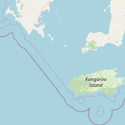
Map view of Western Kangaroo Island Marine Park

Use this park location map to pinpoint Western Kangaroo Island Marine Park in Australia, understand its exact geographic position, and read its mapped placement within the surrounding landscape more clearly.

Pigeon | © OpenStreetMap contributors

Location context for Western Kangaroo Island Marine Park

South Australia
Park atlas

Compare regional marine environments and connected protected landscapes in the southern waters

Explore Other Parks and Protected Areas Near Western Kangaroo Island Marine Park

Browse other parks near Western Kangaroo Island Marine Park to examine similar marine ecosystems across the continental shelf. Continuing into surrounding protected areas reveals broader regional oceanographic networks and diverse seafloor habitats.
National parkSouth Australia
About 27 km away#1 closest

Southeast

Flinders Chase National Park: A Detailed National Park Entry for Map Exploration in South Australia

Explore mapped boundaries and regional geographic context.

This dedicated entry for Flinders Chase National Park provides critical geographic and protected-area data, functioning as a key point within the MoriAtlas for understanding Australia's conservation landscapes. Investigate the specific mapped boundaries of this national park, situate it within the regional geography of South Australia, and grasp its identity as a distinct protected land. The information here supports structured exploration for anyone seeking detailed atlas context on natural park entities.

Area
326.61 km²
Established
1972
IUCN
II
Relief
Upland
National parkSouth Australia
About 78 km away#2 closest

North

Lincoln National Park National Park: Mapped Protected Area and Geographic Landscape Identity

South Australia's protected landscape with detailed park boundaries.

Gain a comprehensive atlas perspective on Lincoln National Park, a designated national park in South Australia. This resource details the park's mapped boundaries, offering clear geographic context and highlighting its role as a protected landscape. Understand its place within the regional geography of South Australia, providing essential data for landscape exploration and atlas-based research.

Area
216.38 km²
Established
1941
IUCN
II
Relief
Upland
National parkAustralia
About 81 km away#3 closest

Northeast

Dhilba Guuranda-Innes National Park: A Detailed Look at Its Australian Protected Landscape

Explore the park's mapped geography and natural terrain.

This section offers a focused atlas exploration of Dhilba Guuranda-Innes National Park, detailing its significance as a protected natural area within Australia. Gain understanding of its unique geographic characteristics, mapped boundaries, and its contribution to the country's diverse natural landscapes. This provides detailed context for anyone interested in Australia's protected land inventory and regional geography.

Area
94.15 km²
Established
1970
Visitors
200K annual
Relief
Mixed relief
National parkAustralia
About 81 km away#4 closest

Northeast

Innes National Park National Park: Mapped Protected Landscape and Regional Geography

Explore its geographic setting and natural terrain.

Delve into the protected landscape and geographic particulars of Innes National Park. This entry provides detailed insights into its mapped boundaries and the surrounding natural terrain within Australia. Understanding Innes National Park's place in the broader geographic atlas helps users compare and contrast protected areas across different regions and nations.

IUCN
II
Marine protected areaSouth Australia
About 97 km away#5 closest

South

Murray Commonwealth Marine Reserve: South Australia Marine Protected Area and Map

Deep-sea canyon geography and critical marine wildlife sanctuary

Spanning from the continental shelf to the depths of the Indian Ocean, the Murray Commonwealth Marine Reserve protects one of Australia's most significant submarine canyon systems. The reserve is essential for its role as a seasonal sanctuary for southern right whales and its complex, deep-water topography that supports diverse marine ecosystems across thousands of square kilometers.

Area
25,803 km²
Established
2007
IUCN
VI
Relief
Lowland
Wildlife reserveSouth Australia
About 101 km away#6 closest

East

Cape Gantheaume Conservation Park: Coastal Landscapes and Protected Area Atlas

South Australia wildlife reserve mapping and geography

Discover the geographic layout of Cape Gantheaume Conservation Park in South Australia. This protected area on Kangaroo Island features a distinct transition between the inland Murray Lagoon wetlands, expansive dune systems at D'Estrees Bay, and the offshore environment of Pelorus Islet, offering a comprehensive view of southern coastal terrain.

Area
42.13 km²
Established
1971
IUCN
Ia
Relief
Lowland
Marine protected areaSouth Australia
About 107 km away#7 closest

Southeast

Southern Kangaroo Island Marine Park: Protected Marine Landscape and Regional Geography

Key ecological features within the South-west Marine Park Network

Spanning the continental shelf south of Kangaroo Island, this marine protected area represents a significant node in South Australian marine conservation. The park encompasses the Kangaroo Island Pool and supports nutrient-rich upwelling systems that drive regional biological productivity. Its mapped boundaries protect essential habitats for large marine predators and serve as a vital calving zone for southern right whales in Commonwealth waters.

Area
629.93 km²
Established
2012
IUCN
VI
Relief
Lowland
Protected areaSouth Australia
About 110 km away#8 closest

Northeast

Carribie Conservation Park: Mapped Geography and Protected Area Overview in South Australia

Ecological terrain and native vegetation remnants on the Yorke Peninsula

Carribie Conservation Park is a 19-hectare protected area situated on the southern Yorke Peninsula of South Australia. The terrain consists of an undulating sandy plain characterized by two contrasting vegetation zones: a northern mallee scrub and a southern sheoak and tea-tree woodland. As a formal conservation site, it provides a vital window into the original botanical character of the region.

Area
0.19 km²
Established
1968
IUCN
III
Relief
Lowland

Common questions about visiting, size, designation, and location context for Western Kangaroo Island Marine Park

Western Kangaroo Island Marine Park FAQs for park facts, access, geography, and protected area context

Find quick answers about Western Kangaroo Island Marine Park, including protected-area facts, park geography, trail and visitor context, and how the park fits into its surrounding country and regional landscape.
MoriAtlas Explorer

Continue Your Protected Areas Search Across the Global Atlas

Deepen your exploration by continuing the structured search for national parks and protected areas worldwide. Utilize the comprehensive filtering capabilities to compare different conservation landscapes and refine your understanding of global park geography. Discover more about the distribution and characteristics of protected natural areas.

Global natural geography