
Mori Atlas logo
Nature reserveWierdense Veld

Examining the complex intersection of active water catchment and rare high bog restoration

Wierdense Veld Nature Reserve: A Mapped Analysis of Protected Bog and Heathland in Overijssel

Wierdense Veld stands as a significant protected landscape in the eastern Netherlands, serving as a critical refuge for raised bog remnants and heathland ecosystems. Located within the province of Overijssel, this site provides a unique opportunity to study the interaction between active drinking water extraction and the long term restoration of fragile peat soil habitats. The terrain features a characteristic mosaic of wet and dry heath, peat pools known as boerenkuilen, and scrub forests that support distinct breeding populations of wetland birds.

raised bogheathlandpeat poolsNatura 2000Overijsseldrinking water catchment
Digital illustration of a deep mountain valley with granite cliff sides, a waterfall cascading down the central cliff, a river winding through the valley floor, and a forest of evergreen and deciduous trees in the foreground.

Wierdense Veld

Nature reserve

Park overview

Structured park overview, official facts, and landscape profile for Wierdense Veld

Wierdense Veld park facts, protected area profile, and essential visitor context

Review the core facts for Wierdense Veld, including designation, size, terrain, visitor scale, habitats, and operating context in one park-focused overview.

About Wierdense Veld

Wierdense Veld is a small but ecologically dense protected landscape in the eastern Netherlands, occupying about 420 hectares of sandy soils north of the N35 between Wierden and Nijverdal. Despite its modest size, it packs together an unusual range of habitats that are now rare in the Netherlands: degraded raised bog, peat cutting pools, wet and dry heath, and birch scrub, all set within a regional matrix that still supports traditional heathland grazing. Because the site is also a working drinking water catchment, its ecological story is closely bound up with the management of groundwater levels, nutrient inputs from surrounding farmland, and the long-running effort to rebuild conditions favorable to new bog growth.

The protected area has been under the stewardship of Landschap Overijssel since 1968, and the relationship between conservation and utility has shaped its character ever since. When Natura 2000 designation was first proposed in 2008, agricultural objections kept the process on hold, but in 2016 the site was finally incorporated into the European network of protected nature areas under the Habitats Directive. The Dutch site code NL9801018 places Wierdense Veld within the broader network of Overijssel and eastern Netherlands habitats that connect to sites like the Sallandse Heuvelrug, Borkeld, and the Vecht and Regge river valleys.

Visually, the site reads as a quiet, low-relief heathland dominated by purple and brown hues in late summer, dotted with dark pools where peat was once cut, and crossed by sandy tracks rather than paved roads. The presence of a large traditional flock of heath sheep gives the area a strongly cultural as well as ecological feel, recalling centuries of common grazing. Wildlife is unobtrusive but diverse, and the site carries notable breeding populations of common crane and snipe, while three snake species, the adder, grass snake, and smooth snake, coexist here in a single small protected landscape that is otherwise closed to most visitors to protect its fragile hydrology.

Quick facts and research context for Wierdense Veld

Wierdense Veld lies in the province of Overijssel in the eastern Netherlands, between the towns of Wierden and Nijverdal, immediately north of the N35 highway. The site covers approximately 420 hectares and has been managed by the conservation organization Landschap Overijssel since 1968. It was formally designated as a Natura 2000 site under the EU Habitats Directive in 2016, after an earlier proposed designation in 2008 had been blocked by agricultural interests.

The site is classified among the higher sandy soils landscapes of the Netherlands and includes one of the last small remnants of raised bog in the region, alongside dry heath, wet heath, peat pools, and birch scrub. It simultaneously functions as an active drinking water catchment, which places the ecological recovery of the bog in direct tension with regional water supply and farming uses.

Protection and recognition

Documented terrestrial protection scope, designation history, and Natura 2000 recognition

Wierdense Veld Protection Status and International Recognition

Wierdense Veld features documented terrestrial protection status established in 2016 alongside official Natura 2000 recognition records. Structured atlas data compiles the designation history and management scope for this protected area.

International recognition

Protection details

Protection scope
Terrestrial
Designated year
2016
Transboundary protection
No
Park context

Deeper park guide and search-rich context for Wierdense Veld

Wierdense Veld history, landscape, wildlife, and travel context

Explore Wierdense Veld through its history, landscape character, ecosystems, wildlife, conservation priorities, cultural context, and seasonal travel timing in a structured park guide built for atlas discovery and search intent.

Why Wierdense Veld stands out

Wierdense Veld is best known for being one of the eastern Netherlands' last surviving patches of raised bog, and for the visible struggle to keep that bog alive against the pressures of nearby agriculture and a functioning drinking water extraction zone. It is also recognized for its open heathland kept clear by a herd of around 300 Veluwe heath sheep, and for the unusually rich combination of three native snake species living side by side within a single small protected area. Within the wider Natura 2000 network, the site carries particular weight as a case study in how a working water catchment can also be a designated conservation area. The presence of breeding common cranes and snipe adds to its profile as a quietly important site for birds tied to wet bog and heath transitions, while the rewetting experiments using foil screens beneath the surface have made it a small but interesting example of active bog restoration in a heavily used Dutch landscape.
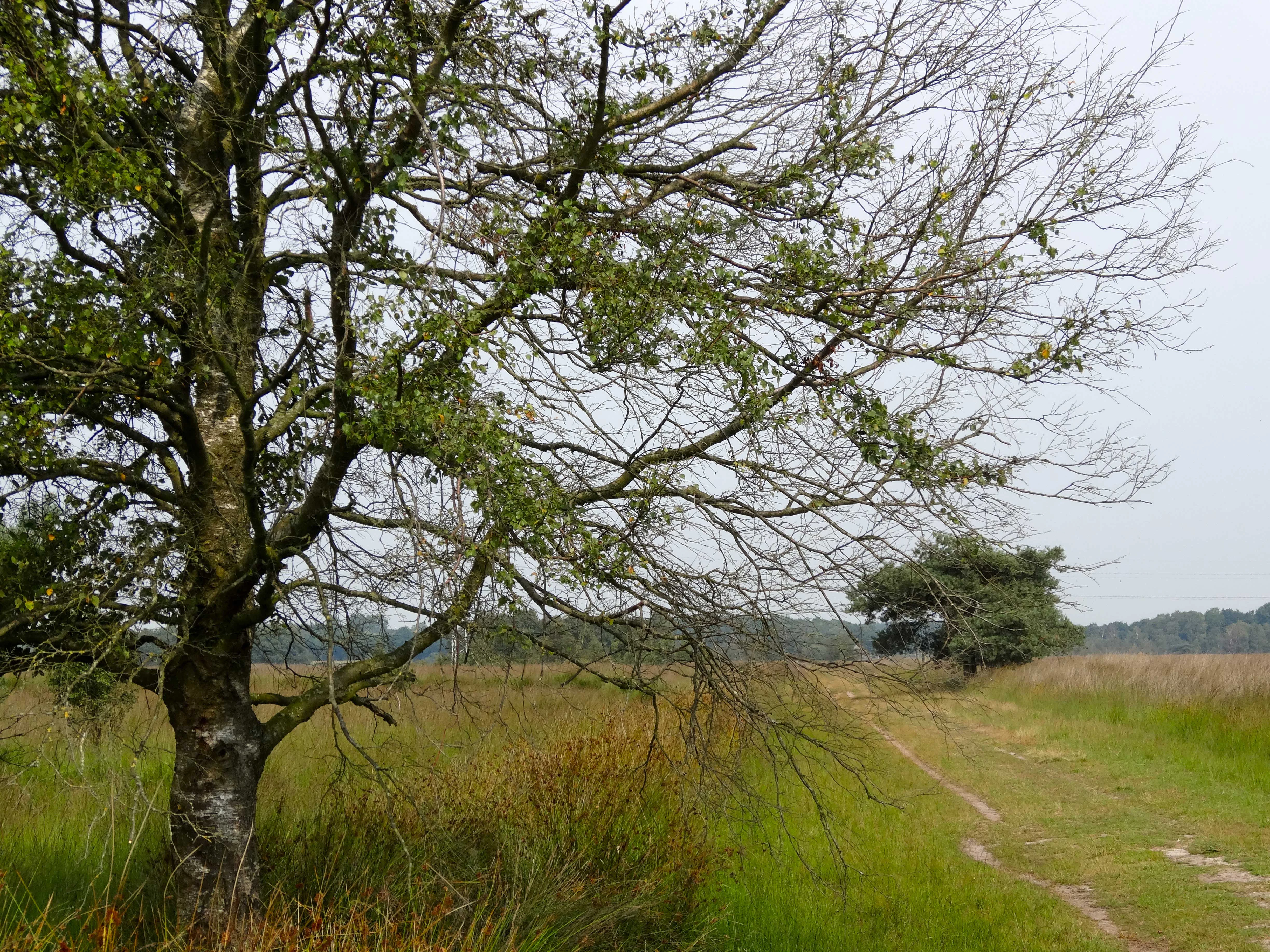
A dirt path leads into the distance through a flat, open heathland landscape with a large birch tree in the immediate foreground under an overcast sky.
A dirt track winds through the heathland and birch thickets of the Wierdense Veld nature reserve.

Wierdense Veld history and protected-area timeline

Wierdense Veld has a long human history shaped by turf cutting, grazing, and more recently water extraction. Like many of the higher sandy soils of eastern Netherlands, parts of the area were once worked for peat, leaving behind the network of peat pools and exposed bog remnants that still define the site today. Centuries of grazing, drainage, and gradual agricultural intensification around the area steadily reduced the extent of intact raised bog.

The modern conservation story begins in 1968, when management of the area was taken up by the regional conservation organization Landschap Overijssel. Under that stewardship the heathland was maintained through sheep grazing, and the area gradually acquired a clearer identity as a protected nature area, although it remained surrounded by working farmland and continued to function as part of the regional drinking water supply.

In 2008 a proposed designation as a Natura 2000 site under the EU Habitats Directive was blocked by agricultural interests concerned about the implications for surrounding land use. The conflict was eventually resolved when the site was officially designated as a Natura 2000 area in 2016. Around 2019 the broader area process weighing ecological, agricultural, and drinking water interests was paused, and the longer-term balance between water supply, farming, and bog restoration has remained a subject of local debate.

Wierdense Veld landscape and geographic character

Wierdense Veld sits on the higher sandy soils of Overijssel, a landscape type common to the eastern Netherlands but increasingly fragmented by agriculture and urbanization. Its terrain is gently undulating rather than dramatic, with low relief and a generally flat to rolling heathland profile. The most visually distinctive features are the peat pools, locally known as boerenkuilen, which mark places where turf was historically cut and which now hold water at or near the surface.

The vegetation mosaic alternates between dry heath, where common heather and grasses dominate, and wetter heath and bog margins where sphagnum mosses and bog specialists can persist. Stands of birch scrub fringe parts of the open area, creating transitional zones between open heath and what remains of the raised bog core. The whole is threaded through with sandy tracks that allow light visitor access without requiring paved infrastructure.

Within the broader regional context, Wierdense Veld is part of a chain of small protected sandy-soil landscapes that includes the nearby Borkeld, the forested higher ground of the Sallandse Heuvelrug to the west, and the wetter Vecht and Regge valley habitats that connect eastward. Its landscape character therefore reads as a piece of an older, larger heathland and bog system that has otherwise been broken up by agriculture over the past century.
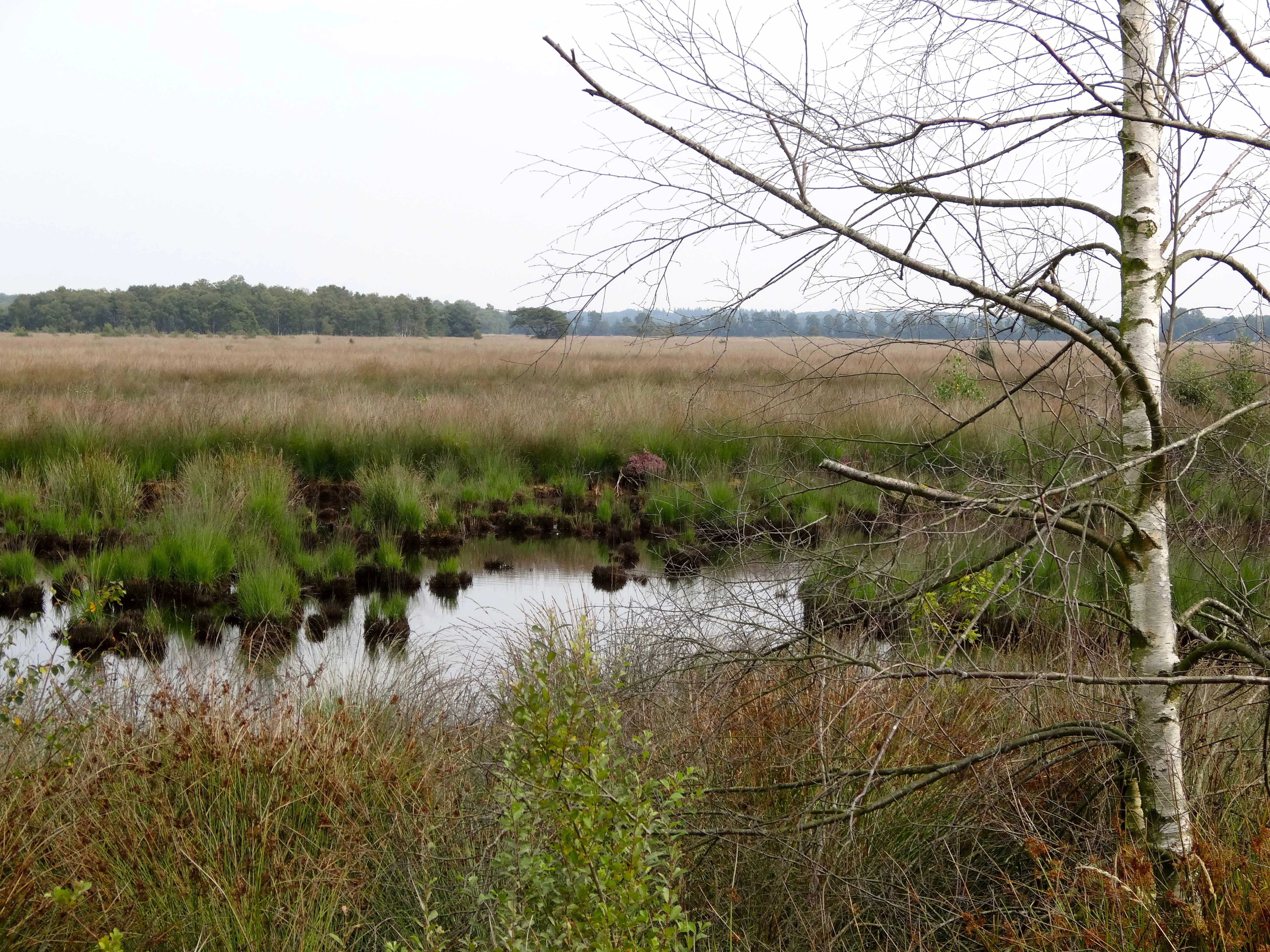
A landscape view of Wierdense Veld showing a small pond with grassy hummocks in the foreground, surrounded by open heathland and birch trees under an overcast sky.
A view of the wet heathland and bog area in Wierdense Veld.

Wierdense Veld ecosystems, habitats, and plant life

Ecologically, Wierdense Veld is best understood as a tension zone between past peat cutting and present-day hydrological recovery. The site covers dry heath, wet heath, peat pools, birch scrub, and a small but ecologically critical remnant of living raised bog. Of the total area, only around 12 hectares still functions as raised bog in any meaningful sense, and this fragment has long suffered from desiccation, nutrient enrichment from surrounding farmland, and the encroachment of coarse grasses.

Management interventions have focused on raising water tables locally by burying foil barriers beneath the surface, blocking lateral drainage losses, and reducing atmospheric nutrient deposition effects. These rewetting efforts have enabled modest new growth of high bog mosses and the return of rare bog plants, while the wider heath mosaic continues to be shaped by grazing and by prevention of further woodland encroachment.

The uniqueness of the ecological profile lies in the marriage of habitats. Within a small footprint one finds terrestrial heath communities, aquatic peat pool environments, peatland vegetation on the verge of recovery, and wet woodland fringes. This compressed diversity is what makes the site ecologically significant despite its small size, and it explains why it has been integrated into both national and European protection frameworks.

Wierdense Veld wildlife and species highlights

Wierdense Veld supports a quietly rich fauna typical of well-managed Dutch heath and bog landscapes. Its most distinctive bird presence includes a breeding population of common cranes, a species closely tied to wet bog edges and surrounding farmland mosaics, and breeding snipe, which use the wetter heath and bog margins during the nesting season. Historically the area also supported black grouse, though that species disappeared from the site by the 1990s as the surrounding landscape became less suitable.

Reptiles are an unusually strong element of the fauna. Three snake species occur together here: the adder, the grass snake, and the smooth snake. The combination is nationally rare and reflects the diversity of microhabitats, including dry heath, damp bog margins, and transitional scrub.

Amphibians also thrive in the wetter parts of the site. The moor frog is associated particularly with the bog and peat pool habitats, while dragonflies such as the high bog emerald are indicators of recovering bog conditions. Carnivorous plants like the round-leaved sundew are present in the wetter areas and reflect the persistence of acidic, nutrient-poor conditions necessary for the full bog-associated community. Heath sheep themselves are a managed presence, but they are part of the landscape's living heritage rather than its wild fauna.

Wierdense Veld conservation status and protection priorities

Wierdense Veld is protected primarily through its Natura 2000 designation under the EU Habitats Directive, which it received in 2016 after a contested process that began in 2008. The site is one of the Netherlands' smaller Natura 2000 areas but carries outsized importance because of its surviving raised bog fragment and the rare combination of bog, heath, and peat pool habitats on higher sandy soils.

The conservation challenge at the site is fundamentally one of water management. The same landscape that is being protected for its bog and heath is also an active drinking water catchment, and the surrounding agricultural land continues to influence nutrient inputs and drainage patterns. Dutch provincial authorities have publicly acknowledged that combining agriculture, drinking water extraction, and nature restoration around Wierdense Veld is difficult, and in 2019 the broader area process aiming to balance these goals was paused.

On the ground, conservation work focuses on hydrological recovery. Buried foil screens raise local groundwater levels, reducing desiccation of the remaining high bog. Grazing by Veluwe heath sheep maintains the structure of the heath and prevents scrub encroachment, and monitoring tracks the recovery of high bog mosses, bog heather, and characteristic fauna. The site's conservation significance rests less on its current ecological condition and more on its potential to rebuild functioning bog and heath habitat within a working water catchment.

Wierdense Veld cultural meaning and human context

Wierdense Veld carries a long cultural memory of common grazing and turf cutting that shaped the eastern Netherlands. The tradition of using open heath for sheep grazing has been preserved at the site through the use of a managed flock of around 300 Veluwe heath sheep, which traces back to centuries of regional land use patterns in which sheep were walked over village commons, kept in local sheepfolds, and produced both wool and meat. The presence of a sheepfold, or schaapskooi, at the site is a tangible reminder of that heritage.

The peat pools themselves are a record of the historical turf economy, when communities cut peat for fuel in shallow excavations now filled with water. Local place names and the term boerenkuilen for these pools preserve that history in the everyday vocabulary of the region. The site is also part of the broader Overijssel identity as a province where the sandy soil landscapes around Twente and Salland have been modified by centuries of gradual human use rather than by sudden industrial transformation.

Top sights and standout views in Wierdense Veld

Wierdense Veld stands out for the improbable coexistence of a working drinking water catchment and an actively recovering piece of raised bog, and for the way in which traditional sheep grazing continues to play a central role in keeping the heath open. Its rare triple presence of adder, grass snake, and smooth snake in a single small landscape, and its breeding populations of common crane and snipe, give it a wildlife profile that punches above its size.

Its hydrological restoration work, including the use of subsurface foil screens to raise groundwater levels, makes the site an interesting small example of bog recovery within the Dutch Natura 2000 network. The larger significance of Wierdense Veld lies in showing how an older heath and bog landscape can be reconciled, however imperfectly, with modern demands for water supply and agricultural land, and how such reconciliation is itself a form of conservation.

Best time to visit Wierdense Veld

The character of Wierdense Veld shifts mainly with the seasons in ways typical of Dutch heathland. Late summer and early autumn, broadly from August into September, are when the heather is in full bloom and the open heath displays its strongest color, while cooler and wetter months bring higher water levels in the peat pools and a quieter, more subdued landscape.

Spring brings renewed bird activity around the bog margins, with breeding common cranes and snipe present in the wetter zones, while autumn often sees the most striking interplay of color between the heath, the bog pools, and the surrounding birch stands. Because the site is highly sensitive and access is limited to a few sandy tracks plus a small freely accessible forested area near the Bruine Hoopsweg, the best time to experience it is whenever conditions are mild enough to walk on the sandy paths without damaging the fragile surface, typically in drier spells from late spring through early autumn.

Monthly climate preview

Long-term representative point measurements tracking monthly temperature ranges and precipitation patterns

Wierdense Veld Climate Normals and Measured Annual Temperature and Precipitation Rhythm

Representative point records for Wierdense Veld document measured monthly temperature ranges alongside consistent daily precipitation averages. Examining the complete twelve-month climatology reveals detailed shifts in long-term thermal and moisture normals across the protected landscape.
Annual mean10 °C
2 °C18 °C
Jan
Feb
Mar
Apr
May13°
Jun16°
Jul18°
Aug18°
Sep15°
Oct10°
Nov
Dec
Warmest month
July

18 °C

Coolest month
January

2 °C

Wettest month
December

2.5 mm/day

Driest month
April

1.4 mm/day

Park location guide

Geography guide, regional context, and park location map for Wierdense Veld

Wierdense Veld park geography, regions, and map view in Netherlands

Understand where Wierdense Veld sits in Netherlands through a broader geographic reading of the surrounding landscape, nearby location context, and its mapped position within the national park landscape.

How Wierdense Veld fits into Netherlands

The Netherlands is a low-lying coastal country in Northwestern Europe, famous for its extensive dike and canal systems that reclaim land from the sea. It consists of twelve provinces and is known for tulips, windmills, and cycling culture. The country is a founding member of the European Union with Amsterdam as its capital and The Hague as the seat of government.

Wider geography shaping Wierdense Veld in Netherlands

The Netherlands is located in Northwestern Europe along the North Sea coastline to the north and west. It borders Germany to the east and Belgium to the south. The country is notably flat, with a significant portion of its territory lying below sea level, protected by dikes and dune systems. It consists of twelve provinces and also includes overseas municipalities in the Caribbean.

Map view of Wierdense Veld

Use this park location map to pinpoint Wierdense Veld in Netherlands, understand its exact geographic position, and read its mapped placement within the surrounding landscape more clearly.

Pigeon | © OpenStreetMap contributors

Location context for Wierdense Veld

Overijssel

Visualizing raised bogs, peat pools, and sandy heath habitats

Wierdense Veld Landscape and Scenery Photography

Visual records reveal the diverse terrain, wet heath mosaics, and delicate raised bog remnants characteristic of Wierdense Veld. Examining these protected area photographs provides a clearer understanding of active ecological restoration and regional conservation landscapes.

A dirt path leads into the distance through a flat, open heathland landscape with a large birch tree in the immediate foreground under an overcast sky.

A traditional wooden building with a large thatched roof, known as a sheepfold, stands in a grassy field at the edge of the Wierdense Veld nature reserve, with sheep grazing in the distance.

A landscape view of Wierdense Veld showing a small pond with grassy hummocks in the foreground, surrounded by open heathland and birch trees under an overcast sky.

Park atlas

Compare regional sandy soils, heathlands, and wetland habitats across Overijssel

Exploring Other Parks and Protected Areas Near Wierdense Veld

Browsing other protected areas near Wierdense Veld reveals connected regional ecosystems and similar sandy soil habitats across the surrounding landscape. Comparing these neighboring nature reserves provides valuable context for understanding wetland restoration and local conservation efforts.
Watercolor painting showing green hills, a lake, and distant mountains under a light sky
National parkOverijssel
2.9 km away#1 closest

Southwest

Sallandse Heuvelrug National Park: Overijssel's Glacial Ridge Protected Landscape

Explore its heathland geography and mapped park boundaries.

Sallandse Heuvelrug National Park represents a significant protected landscape within Overijssel, Netherlands, notable for its distinctive glacial ridges and extensive heathland ecosystems. As one of the country's most important conservation areas, it offers a unique opportunity to study the mapped topography and the geography of Dutch heathlands. Discover the protected area's contours and its place within the broader regional atlas context, appreciating its geological formations and ecological importance.

Area
35 km²
Established
2004
IUCN
II
Relief
Upland
Watercolor painting of a wide landscape with clusters of trees, green meadows, and soft, distant hills under a pastel sky.
Nature reserveOverijssel
About 9.3 km away#2 closest

South

Borkeld Nature Reserve: Overijssel Protected Landscape and Geographic Atlas

Heathland, juniper shrubland, and prehistoric archaeological terrain

Discover the geographic character of the Borkeld nature reserve in Overijssel. This protected area stands out for its large juniper shrubland, unique clay pit habitats, and deep archaeological history preserved within a gently rolling landscape of forest and heath.

Area
6 km²
Relief
Upland
Climate
Temperate
Access
Easy access
Nature reserveOverijssel
10 km away#3 closest

Northeast

Engbertsdijksvenen Nature Reserve: Mapping Dutch Raised Bog and Peatland Landscapes

Protected high moor geography in the Overijssel region

Engbertsdijksvenen is a significant nature reserve in the eastern Netherlands, renowned for its extensive living raised bog and diverse peatland habitats. The site showcases a rare mosaic of open water, heathland, and bog forest, serving as a landmark for ecological restoration and wetland geography in the province of Overijssel.

Area
10 km²
Relief
Upland
Climate
Temperate
Access
Easy access
A minimalist watercolor illustration depicting green rolling hills, a cluster of trees in the foreground, and a body of water under a pale sky.
Nature reserveOverijssel
11 km away#4 closest

West

Boetelerveld Nature Reserve: Landscape Geography and Protected Habitat Mapping

A critical wet heathland remnant in the Overijssel region.

Situated in the Salland region of Overijssel, Boetelerveld represents a dense convergence of heath, conifer forest, and small peat-influenced pools. The reserve is notable for its role as a protected area within the Natura 2000 network, offering insight into the restoration of sandy soil ecosystems and the preservation of rare, moisture-dependent flora and fauna in the eastern Netherlands.

Area
1.7 km²
Relief
Lowland
Climate
Temperate
Access
Easy access
Protected areaOverijssel
19 km away#5 closest

East

Springendal & Dal van de Mosbeek Protected Area: Mapped Geography and Terrain Overview

Glacial push-moraine landscapes in the Overijssel province

The Springendal & Dal van de Mosbeek protected area stands out for its concentrated geological diversity, where boulder-clay layers trigger consistent groundwater seepage. This natural process maintains rare ash-elm spring forests and calcareous mires within a twelve square kilometer expanse. The area preserves a classic Twente cultural pattern of small meadows and hedgerows, creating a protected sanctuary for specialized invertebrates and woodland wildlife.

Area
12.25 km²
Established
2013
Relief
Upland
Scope
Terrestrial
Nature reserveOverijssel
About 24 km away#6 closest

Southeast

Landgoed Lonnekermeer Nature Reserve: Geographic Landscape and Protected Area Mapping

Twente region, Overijssel province, Netherlands

Landgoed Lonnekermeer is a 98 hectare nature reserve in Overijssel characterized by a designed early twentieth century landscape, lakes originating from historic sand quarries, and expansive wet heath. Explore the protected boundaries of this estate as it serves as a living model for habitat restoration, showcasing the successful recovery of local fens, brooks, and biodiversity-rich hay meadows within the eastern Netherlands.

Area
1.05 km²
Established
1902
Relief
Lowland
Climate
Temperate
Nature reserveGelderland
27 km away#7 closest

South

Stelkampsveld Protected Nature Reserve and Restored Achterhoek Kampenlandschap in Gelderland

Tracing the mapped boundaries of historic heath and fen ecosystems

Stelkampsveld acts as an ecologically distinctive protected area in the eastern Netherlands. Covering 102 hectares, the terrain showcases a recovered mosaic of hedgerows, small enclosed fields, and re-established wetlands. The site is recognized for its botanical diversity, including rare orchid and moss species within the broader Natura 2000 network of Gelderland.

Area
1.02 km²
Established
2013
Relief
Lowland
Climate
Temperate
A soft watercolor painting of a green meadow landscape with a small pond, cattails, and gentle forested hills in the background.
Nature reserveOverijssel
About 29 km away#8 closest

East

Landgoederen Oldenzaal: Mapping the Protected Estate Forests of Overijssel

Nature reserve geography and habitat connectivity in Twente

Landgoederen Oldenzaal comprises a series of historical estates at the foot of the Oldenzaal ice-pushed ridge. The landscape is characterized by mature woodland complexes, spring-fed brooks, and a traditional field pattern that persists today. As a protected Natura 2000 site, it demonstrates successful habitat reconnection through specialized infrastructure within the wider Twente region.

Area
5.78 km²
Established
2013
Relief
Upland
Climate
Temperate

Common questions about visiting, size, designation, and location context for Wierdense Veld

Wierdense Veld FAQs for park facts, access, geography, and protected area context

Find quick answers about Wierdense Veld, including protected-area facts, park geography, trail and visitor context, and how the park fits into its surrounding country and regional landscape.
MoriAtlas Explorer

Continue Your Protected Areas Search Across the Global Atlas

Deepen your exploration by continuing the structured search for national parks and protected areas worldwide. Utilize the comprehensive filtering capabilities to compare different conservation landscapes and refine your understanding of global park geography. Discover more about the distribution and characteristics of protected natural areas.

Global natural geography