Mori Atlas logo
Nature reserveWiesen bei Dreisel

Investigating the Umlaufberg landforms and protected meadow mosaics of the Lower Sieg River corridor.

Wiesen bei Dreisel Nature Reserve: A Detailed Atlas of the Sieg Valley Floodplain Landscape

Wiesen bei Dreisel preserves a unique ecological mosaic where a former Sieg river meander has evolved into a protected refuge. This site in North Rhine-Westphalia features an Umlaufberg hill flanked by nutrient-poor slopes and saturated wet meadows, supporting a specialized butterfly population reliant on Great Burnet. Gain geographic insight into this compact river floodplain, where traditional vegetation patterns create a vital, high-value habitat gradient within the regional terrain.

meadowwet grasslandSieg valleyfloodplainNatura 2000FFH site

Wiesen bei Dreisel

Nature reserve

Park overview

Structured park overview, official facts, and landscape profile for Wiesen bei Dreisel

Wiesen bei Dreisel park facts, protected area profile, and essential visitor context

Review the core facts for Wiesen bei Dreisel, including designation, size, terrain, visitor scale, habitats, and operating context in one park-focused overview.

About Wiesen bei Dreisel

Wiesen bei Dreisel sits in the Sieg valley in the municipality of Windeck, in the eastern foothills of the Rhenish Massif region of North Rhine-Westphalia. It was formally registered in 1952 as a German nature reserve under the name Ehemalige Siegschleife bei Dreisel, referring to the former loop of the River Sieg that once flowed through this stretch of valley. When the river straightened its course and abandoned the old meander, the isolated channel bed evolved over time into floodplain meadows, reeds, and wet tall-herb grassland, while the encircling hill, an Umlaufberg, became a dry-slope refuge for nutrient-poor meadow vegetation.

The site has since been integrated into the European Natura 2000 network as a Fauna-Flora-Habitat area, with the code DE-5211-302. Administratively, it is managed by the Lower Landscape Authority of the Rhein-Sieg-Kreis, and its boundaries correspond closely with the older national nature reserve designation. Although modest at just seventy-three hectares, the area embodies a tight mosaic of habitat types that are otherwise increasingly rare in the heavily used landscape of western Germany.

At the heart of the area's ecological importance are its wet meadows dominated by Great Burnet (Großer Wiesenknopf), the indispensable host plant for the rare Dusky Large Blue and Scarce Large Blue butterflies. The site's combination of unfertilized meadow, sedge beds, reed stands, moist tall herb fringes, and dry lean slope grassland produces exactly the structural diversity that these specialized invertebrates need to complete their life cycles. As a result, Wiesen bei Dreisel has become a recognized local stronghold for meadow biodiversity in the Sieg valley.

Quick facts and research context for Wiesen bei Dreisel

Wiesen bei Dreisel is a Natura 2000 Habitats Directive site in Windeck, Rhein-Sieg-Kreis, North Rhine-Westphalia, Germany. It is registered under the EU code DE-5211-302 and IUCN Category IV management area designation. The site covers roughly seventy-three hectares across the floodplain of a former Sieg meander between Dreisel and Helpenstell.

It is administered by the Lower Landscape Authority of the Rhein-Sieg-Kreis and was first designated as a protected area in the early 1950s. Its ecological significance is closely tied to nearly undisturbed wet meadows, sedge and reed communities, and the presence of two rare Wiesenknopf-associated blue butterfly species.

Protection and recognition

Documented Natura 2000 listings and formal conservation records for Wiesen bei Dreisel

Wiesen bei Dreisel Protection Status and International Recognition Data

Wiesen bei Dreisel maintains documented protection status details alongside official Natura 2000 recognition records within the global conservation database. Conservation analysts and researchers rely on these verified international listings to review formal protected area designations.
Park context

Deeper park guide and search-rich context for Wiesen bei Dreisel

Wiesen bei Dreisel history, landscape, wildlife, and travel context

Explore Wiesen bei Dreisel through its history, landscape character, ecosystems, wildlife, conservation priorities, cultural context, and seasonal travel timing in a structured park guide built for atlas discovery and search intent.

Why Wiesen bei Dreisel stands out

Wiesen bei Dreisel is best known as a refuge for two rare blue butterfly species whose entire life cycle is bound to the Great Burnet plant and to specific host ants. The combination of intact wet meadows, moist tall herb vegetation, sedge beds, and adjacent nutrient-poor slope grassland forms the precise habitat mosaic these butterflies require. Beyond the butterflies themselves, the site is also valued as a textbook example of a former Sieg river meander that has transformed into species-rich floodplain grassland. The presence of an Umlaufberg, the classic oval hill formed when a river cuts a shorter channel and isolates a loop, gives the area additional landscape character.
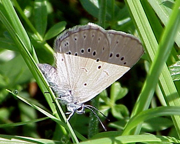
A close-up view of a dusky blue butterfly with black spots on its wings resting on green grass blades.
A Maculinea teleius butterfly resting on vegetation in the Wiesen bei Dreisel nature reserve.

Wiesen bei Dreisel history and protected-area timeline

Wiesen bei Dreisel originated from the natural evolution of an abandoned Sieg river meander and was first given formal protection in 1952 as the nature reserve Ehemalige Siegschleife bei Dreisel. The site reflects a typical post-meander landscape in which the river once described a wide loop, then cut a shorter channel and left behind an Umlaufberg accompanied by wet and dry grassland communities.

Following Germany integration into the European Union's Natura 2000 network, the same area was registered as a Fauna-Flora-Habitat site under the code DE-5211-302. The Natura 2000 designation overlaps almost entirely with the older national nature reserve, reinforcing its protected status under European Habitats Directive law. The area is administered by the Lower Landscape Authority of the Rhein-Sieg-Kreis.

In 2010, conservation managers reported disturbances linked to traditional local uses that had resurfaced in the area, including the placement of honeybee hives and vehicle traffic after fences were cut. These incidents highlight the ongoing management challenge of balancing long-standing local customary practices on former common land with the specific habitat requirements of the rare butterflies protected under the designation.

Wiesen bei Dreisel landscape and geographic character

The landscape of Wiesen bei Dreisel is shaped almost entirely by the ghost of an old Sieg river loop. The area lies between the villages of Dreisel and Helpenstell, in the lower Sieg valley of the Rhein-Sieg-Kreis. The most conspicuous landform is the Umlaufberg, an oval hill left behind by the river when it cut across the neck of a meander and shortened its course. The dry slopes of this hill carry nutrient-poor, species-rich grassland, while the lower ground within the abandoned loop has become a mosaic of wet meadow, sedge bed, reed stand, and tall herb fringe.

This compact alternation of dry, lean slope and moist, meadow-rich valley floor is exactly what gives the protected area its unusual character. Although the site is small, the contrast between the dry, sun-exposed slopes of the Umlaufberg and the lush, sometimes saturated low-ground vegetation is unusually sharp, creating a strong ecological gradient within a very short distance. The result is a landscape that reads at once as a worked agricultural valley and as a remnant natural floodplain mosaic.

Wiesen bei Dreisel ecosystems, habitats, and plant life

Ecologically, Wiesen bei Dreisel is defined by its unusually complete grassland mosaic for such a small area. The habitat inventory includes Glatthafer meadows, Wiesenknopf-Silgenwiesen, moist tall herb communities, sedge beds, and reed stands. These vegetation types are increasingly rare in intensively farmed lowland Germany, and within the Sieg valley they form an important local reservoir of meadow flora.

The slopes of the Umlaufberg support dry, nutrient-poor grasslands with characteristic continental elements, while the bottom of the old meander carries the wet and moist communities that depend on the high groundwater table of the former river bed. The juxtaposition of these communities is not just scenic; it is the structural foundation on which the area's most specialized fauna depends. The patches of Great Burnet are particularly important, because this single plant species anchors the food web for two rare butterfly species and their associated ant hosts.

Wiesen bei Dreisel wildlife and species highlights

The wildlife profile of Wiesen bei Dreisel is dominated by two rare butterflies: the Dusky Large Blue, known in German as the Dunkler Wiesenknopf-Ameisenbläuling, and the Scarce Large Blue, or Heller Wiesenknopf-Ameisenbläuling. Both species have extraordinarily specific life histories. Their caterpillars feed exclusively on the flowers of Great Burnet, and after an early feeding phase they are adopted into the nests of particular ant species, inside which they continue to develop. As a result, the butterflies can only complete their life cycle where Great Burnet, the correct host ants, and suitable sward structure occur together.

This dependence makes populations highly localized, and the Sieg valley meadows around Dreisel serve as one of the more important refuges for both species in the region. Beyond the butterflies, the sedge beds, reed stands, and tall herb fringes of the former meander provide breeding and feeding habitat for typical wet-meadow invertebrates, while the dry slopes of the Umlaufberg harbor dry-grassland insects, spiders, and a richer flora of meadow plants than the surrounding working farmland.

Wiesen bei Dreisel conservation status and protection priorities

Conservation value at Wiesen bei Dreisel centers on the protection of a high-quality meadow complex that still supports viable populations of the Dusky Large Blue and Scarce Large Blue butterflies. These species are not only nationally rare in Germany but are also listed under the EU Habitats Directive, so the site is part of a transnational network aimed at maintaining and restoring their habitat. The site's Natura 2000 status means that its management must aim to preserve the full range of the habitat mosaic, not just the most visible wetland portion.

At the national level, the area has been a registered nature reserve since 1952, providing decades of legal protection. The site's long history has allowed characteristic meadow and tall-herb vegetation to mature, and the present management challenge is to safeguard that continuity against pressures such as nutrient enrichment, unsuitable mowing regimes, encroachment of woody plants, and conflicts with traditional local land uses such as honeybee keeping or vehicle access. Because the butterflies link several organisms, the ants and the burnet plant, into a single habitat requirement, the area effectively serves as an umbrella for the conservation of the entire meadow community.

Wiesen bei Dreisel cultural meaning and human context

The name Ehemalige Siegschleife bei Dreisel and the longstanding nature reserve border are rooted in the rural history of the Windeck municipality, where common land and traditional meadow use long shaped the Sieg valley. In 2010, conservation managers noted that disturbances in the area appeared to be tied to the reactivation of old customary usage rights, including honeybee keeping and vehicle movement, which illustrates the long history of community interaction with this particular valley floor.

The valley setting between Dreisel and Helpenstell is part of a broader pattern of small Sieg valley settlements whose economy historically combined hay meadows, livestock, and traditional use of common resources. Today the area sits at the intersection of that working rural landscape and modern European nature protection law, which gives Wiesen bei Dreisel a quiet cultural dimension tied to the long coexistence of farming and floodplain ecology in this part of the Rhenish Massif foothills.

Top sights and standout views in Wiesen bei Dreisel

Wiesen bei Dreisel stands out for the close match between a small protected footprint and an exceptionally complete meadow habitat mosaic, from dry Umlaufberg slope through tall herb fringe to wet sedge meadow. The site is a regional stronghold for two rare blue butterfly species whose entire life cycles revolve around Great Burnet and specific host ants.

Other notable features include the site's 1952 protection date, its long-standing dual designation as both a national nature reserve and a Natura 2000 habitat area, and the dramatic but compact landform sequence left behind by an old Sieg meander. Although small, the site plays a disproportionately important ecological role in the Windeck stretch of the Sieg valley.

Best time to visit Wiesen bei Dreisel

The characteristic vegetation of Wiesen bei Dreisel is most expressive in late spring and summer, when the Glatthafer meadows, tall herb fringes, and Great Burnet stands are in full bloom. This is also the period when the Dusky Large Blue and Scarce Large Blue butterflies are most likely to be on the wing around their burnet host plants.

Visits in late spring tend to showcase the fresh meadow character and the wildflowers of the Umlaufberg slopes, while mid and late summer bring the tall herb communities and reed stands into their fullest expression. Wet ground conditions and modest informal access make the area most comfortable in drier weather, and timing a visit to align with the bloom of Great Burnet offers the best chance to observe the butterflies for which the site is best known.

Monthly climate preview

Measured monthly climate averages and representative point data for Wiesen bei Dreisel

Wiesen bei Dreisel Climate Normals, Long-Term Temperature and Precipitation Rhythm

Representative coordinates record long-term monthly temperature and precipitation cycles across the elevation profile of Wiesen bei Dreisel. Accessing the complete monthly profile provides detailed historical baseline values for thorough environmental analysis.
Annual mean9 °C
0 °C18 °C
Jan
Feb
Mar
Apr
May13°
Jun16°
Jul18°
Aug18°
Sep14°
Oct
Nov
Dec
Warmest month
July

18.3 °C

Coolest month
January

0.3 °C

Wettest month
December

3 mm/day

Driest month
April

1.8 mm/day

Park location guide

Geography guide, regional context, and park location map for Wiesen bei Dreisel

Wiesen bei Dreisel park geography, regions, and map view in Germany

Understand where Wiesen bei Dreisel sits in Germany through a broader geographic reading of the surrounding landscape, nearby location context, and its mapped position within the national park landscape.

How Wiesen bei Dreisel fits into Germany

Germany is a federal republic in Western and Central Europe with a population of over 83 million across sixteen constituent states. It is Europe's largest economy by nominal GDP and a major global exporter and importer. The capital is Berlin, and the country borders Denmark, Poland, Czech Republic, Austria, Switzerland, France, Luxembourg, Belgium, and the Netherlands.

Wider geography shaping Wiesen bei Dreisel in Germany

Germany is located in Western and Central Europe, spanning 357,022 km². It borders Denmark to the north, Poland and the Czech Republic to the east, Austria and Switzerland to the south, and France, Luxembourg, Belgium, and the Netherlands to the west. The country has coastlines on the Baltic Sea and North Sea to the north, with the Alps located in the southern region.

Map view of Wiesen bei Dreisel

Use this park location map to pinpoint Wiesen bei Dreisel in Germany, understand its exact geographic position, and read its mapped placement within the surrounding landscape more clearly.

Pigeon | © OpenStreetMap contributors

Location context for Wiesen bei Dreisel

North Rhine-Westphalia
Recorded earthquake history

Examine the Recorded Earthquake History for Wiesen bei Dreisel

Explore a structured collection of past seismic events documented in the area surrounding Wiesen bei Dreisel. This MoriAtlas archive offers a transparent view of historical epicentre records associated with this protected landscape in North Rhine-Westphalia.

Wiesen bei Dreisel Earthquake History

Catalogued events

14 events

Strongest magnitude

Magnitude 5.2

Most recent event

Sep 29, 2008

This history includes earthquakes recorded inside the park or within 50 km of its borders

Explore photographic records of floodplain meadows, rare butterfly habitats, and isolated Umlaufberg terrain.

Wiesen bei Dreisel Photos and Landscape Scenery: Visualizing Protected River Meanders

Visual documentation captures the distinctive landforms, wet meadows, and river meanders that define Wiesen bei Dreisel. Examining these habitat photographs reveals the complex ecological gradients and protected valley terrain found within the Sieg river corridor.

A close-up view of a dusky blue butterfly with black spots on its wings resting on green grass blades.

Park atlas

Compare adjacent river valleys and regional conservation areas in North Rhine-Westphalia

Explore Parks Near Wiesen bei Dreisel and Surrounding Protected Landscapes

Browse other parks near Wiesen bei Dreisel to compare similar floodplain meadows and river valley habitats across the surrounding region. Extending the geographic review reveals connected conservation areas and broader ecological patterns within the local river basin.
A horizontal watercolor painting depicting a winding river through a soft, green landscape with trees and distant hills under a pale, warm sky.
Nature reserveNorth Rhine-Westphalia
About 1.1 km away#1 closest

West

Siegaue in den Gemeinden Windeck, Eitorf und der Stadt Hennef Nature Reserve Atlas

River floodplain and riparian protected landscapes in Germany

Spanning municipalities across the Rhein-Sieg-Kreis, this nature reserve protects a mosaic of wet meadows, reedbeds, and alluvial flats along the Sieg river. The site maintains a passable aquatic habitat and traditional floodplain structure, serving as a critical component of the regional biotope network in North Rhine-Westphalia.

Area
8.128 km²
Established
1992
Relief
Upland
Climate
Temperate
Nature reserveNorth Rhine-Westphalia
About 18 km away#2 closest

Northeast

Laubwälder am Mun-Depot: A Protected Woodland Map in the Oberbergischer Kreis

Geographic atlas of a rewilded military site in western Germany

Covering 22.7 hectares within the municipality of Reichshof, Laubwälder am Mun-Depot serves as a crucial habitat and species management area. This nature reserve, established to preserve broadleaf deciduous forest, plays an essential role in local biodiversity conservation, particularly for bat populations navigating the gently rolling terrain of the Bergisches Land region.

Area
0.227 km²
Established
2014
IUCN
IV
Relief
Upland
A soft watercolor illustration showing a hazy, green-toned landscape with a grassy or forested foreground and gently rolling hills in the background.
Nature reserveNordrhein-Westfalen
About 22 km away#3 closest

Northeast

Seelbachs- und Eulenbruchswald: Nature Reserve Landscape and Regional Geography

Mapping protected deciduous forests and riparian habitats in Siegerland

The Seelbachs- und Eulenbruchswald nature reserve in Nordrhein-Westfalen is a protected forest complex defined by its extensive beech stands and stream-fed valleys. This geographic entity showcases the structural complexity of central European low mountain woodlands, offering a unique opportunity to study the interplay between old-growth forest, wet meadow systems, and the broader Rhenish Slate Mountains landscape.

Area
1.672 km²
Relief
Upland
Climate
Temperate
Scope
Terrestrial
A soft watercolor illustration of a landscape with green forest tree lines in the foreground, wetland grasses, and pale rolling hills in the background against a white sky.
Nature reserveNordrhein-Westfalen
About 23 km away#4 closest

Northwest

Naturschutzgebiet Schlingenbachtal: Protected Stream Valley and Floodplain Geography

A vital riparian habitat reserve in Nordrhein-Westfalen, Germany

Naturschutzgebiet Schlingenbachtal protects a nearly complete stream-valley ecosystem, featuring an intricate network of wet meadows, alder carr, and forested slopes. By preserving the natural course of the Schlingenbach, the reserve functions as an essential node within regional habitat networks, offering a distinct study in riparian geography and forest land management.

Area
0.689 km²
Established
1988
IUCN
IV
A soft watercolor painting of a wide, flat landscape with a winding stream and light green hills under a hazy sky.
Nature reserveRhineland-Palatinate
About 27 km away#5 closest

Southeast

Dreifelder Weiher Nature Reserve and Westerwälder Seenplatte Protected Geography

A historic pond ecosystem in the northern Westerwald highlands

Spanning 123 hectares, Dreifelder Weiher serves as a vital nature reserve within the Rhenish Massif. Its shallow basin and seasonal drawdown cycles sustain a diverse landscape of reedbelts and marshes, reflecting the deep integration of German noble history and contemporary habitat protection.

Area
1.23 km²
Established
1668
Relief
Lowland
Climate
Temperate
A pale, minimalist watercolor painting showing a winding river flowing through a forested valley with rolling hills in the background.
Protected landscapeRhineland-Palatinate
About 28 km away#6 closest

Southwest

Naturpark Rhein-Westerwald: Protected Landscapes of the Middle Rhine and Westerwald Plateaus

A historic protected area spanning Rhine river slopes and volcanic ridges

Naturpark Rhein-Westerwald defines a critical geographic corridor in Rhineland-Palatinate, bridging the gap between the Rhine valley floor and the Westerwald highlands. This protected landscape preserves a sequence of volcanic ridges, dense mixed forests, and deep river valleys that serve as a testament to the region's complex geological history and long-standing conservation efforts.

Area
470 km²
Established
1962
Relief
Upland
Scope
Terrestrial
Nature reserveRheinland-Pfalz
About 29 km away#7 closest

Southeast

Westerwälder Seen: Nature Reserve Geography and Mapped Pond Landscape in Rhineland-Palatinate

Historic reservoir systems, wetland habitats, and upland plateau terrain

Westerwälder Seen is a sprawling nature reserve defined by its system of seven interconnected, man-made ponds and surrounding wetland fringes. Located in the heart of the Westerwald in Rhineland-Palatinate, this site serves as a prime example of historical land management evolving into a vital ecological refuge for waterbirds, amphibians, and diverse brook forest communities.

Area
2.28 km²
Established
1650
Relief
Upland
Climate
Temperate
A horizontal watercolor painting showing a calm lake or pond with grassy banks, small trees, and soft hills in the background.
Protected areaGermany
About 29 km away#8 closest

Southeast

Brinkenweiher Protected Area and Westerwald Lake District Geography

Historic wetland habitat in Rhineland-Palatinate

Brinkenweiher serves as a significant example of a seventeenth-century Waldweiher, shaped by human engineering to dam the Holzbach headwaters. Today, the site functions as a protected nature reserve, offering a varied landscape of shadowed forest fringes, marshy wetlands, and open meadows that support a coherent wetland ecosystem within the broader Westerwälder Seenplatte.

Area
0.21 km²
Established
1660
Relief
Lowland
Scope
Terrestrial

Common questions about visiting, size, designation, and location context for Wiesen bei Dreisel

Wiesen bei Dreisel FAQs for park facts, access, geography, and protected area context

Find quick answers about Wiesen bei Dreisel, including protected-area facts, park geography, trail and visitor context, and how the park fits into its surrounding country and regional landscape.
MoriAtlas Explorer

Continue Your Protected Areas Search Across the Global Atlas

Deepen your exploration by continuing the structured search for national parks and protected areas worldwide. Utilize the comprehensive filtering capabilities to compare different conservation landscapes and refine your understanding of global park geography. Discover more about the distribution and characteristics of protected natural areas.

Global natural geography