

Mori Atlas logo
Nature reserveWindsor Downs Nature Reserve

Analyzing the ecological significance and terrain of this vital urban fringe protected area

Windsor Downs Nature Reserve: Mapped Protected Landscapes and Cumberland Plain Woodland Geography

Windsor Downs Nature Reserve represents a critical protected landscape located within the undulating terrain of the Cumberland Plain in western Sydney, New South Wales. This reserve preserves one of the last remaining stands of endangered Cumberland Plain Woodland, offering a detailed look at how ironbark forests and sclerophyll woodlands persist in an urbanized region. The landscape serves as an essential island for biodiversity, supporting threatened plant species and avian populations while providing a clear window into the regional geography of the Sydney metropolitan area.

Windsor DownsCumberland Plain Woodlandwestern Sydneyendangered ecological communityNSW national parksstrict nature reserve

Windsor Downs Nature Reserve

Nature reserve

Park overview

Structured park overview, official facts, and landscape profile for Windsor Downs Nature Reserve

Windsor Downs Nature Reserve park facts, protected area profile, and essential visitor context

Review the core facts for Windsor Downs Nature Reserve, including designation, size, terrain, visitor scale, habitats, and operating context in one park-focused overview.

About Windsor Downs Nature Reserve

Windsor Downs Nature Reserve sits on a low ridge of the Cumberland Plain on the northwestern outskirts of Sydney, between the suburbs of Windsor Downs and Bligh Park. Although small in area, its location and ecological character give it an outsized conservation role. The reserve safeguards a fragment of Cumberland Plain Woodland, the grassy eucalypt woodland that historically dominated the shale-based lowlands west of Sydney and has now been reduced to a tiny fraction of its former extent.

The reserve has a layered human and ecological history. Before European settlement the land lay within the country of the Darug people, and Aboriginal campsites along with stone tools have been recorded within the reserve. During the twentieth century the property was held by the Riverstone Meatworks for more than a century, during which it was cleared and used for cattle grazing. The old meatworks water tower and concrete water troughs from that era still stand in the reserve, providing a tangible link to this pastoral and industrial past. In the late 1980s, shortly before the meatworks ceased operations, the land was transferred to New South Wales National Parks and Wildlife and was opened as a state park in 1990.

Ecologically, the reserve is shaped by its soils. Heavier clay substrates support open forest dominated by ironbarks such as Eucalyptus fibrosa and Eucalyptus sideroxylon, while sandier soils carry woodlands of Eucalyptus sclerophylla. Disturbed former grazing areas have been colonised by sub-mature hakeas, creating a patchwork of regeneration stages. This mosaic of vegetation types supports a diverse community of native fauna, including eastern grey kangaroos, swamp wallabies, sugar gliders, common brushtail and ringtail possums, and an array of reptiles such as goannas, eastern brown snakes, red-bellied black snakes, and blue-tongued lizards. Birdwatchers have recorded at least sixty-eight species, with yellow-tailed black cockatoos, sulphur-crested cockatoos, and laughing kookaburras common sights. The reserve also hosts one of the few remaining populations of red-capped robins in Sydney and, significantly, a known population of the endangered regent honeyeater.

The importance of Windsor Downs extends beyond its individual biodiversity values. As a surviving stand of Cumberland Plain Woodland surrounded by expanding suburbs, it stands as a reference point for the original ecological character of the western Sydney plain and a working example of how remnant patches can be protected and managed in heavily urbanised landscapes.

Quick facts and research context for Windsor Downs Nature Reserve

Windsor Downs Nature Reserve is a 3.64 square kilometre protected area located between the suburbs of Windsor Downs and Bligh Park in western Sydney, New South Wales. It is classified as a strict nature reserve under the IUCN system and is managed by the NSW National Parks and Wildlife Service.

The reserve was formally established on 7 September 1990 on land that had previously belonged to the Riverstone Meatworks for over a century. It preserves part of the critically reduced Cumberland Plain Woodland community and supports both threatened flora and a population of endangered regent honeyeaters.

Protection and recognition

Documented terrestrial protection scope and international recognition records

Windsor Downs Nature Reserve Protection Status and Governance Data

Windsor Downs Nature Reserve maintains a documented terrestrial protection scope without imported international recognition sources or transboundary status. Reviewing structured conservation records provides baseline administrative data for this protected area.

Protection details

Protection scope
Terrestrial
Transboundary protection
No
Park context

Deeper park guide and search-rich context for Windsor Downs Nature Reserve

Windsor Downs Nature Reserve history, landscape, wildlife, and travel context

Explore Windsor Downs Nature Reserve through its history, landscape character, ecosystems, wildlife, conservation priorities, cultural context, and seasonal travel timing in a structured park guide built for atlas discovery and search intent.

Why Windsor Downs Nature Reserve stands out

Windsor Downs Nature Reserve is best known for protecting a remnant of Cumberland Plain Woodland, a critically endangered ecological community native to the western Sydney region. The reserve is often cited as one of the small but ecologically significant pockets where this woodland type still survives amid extensive urban development. It is also notable for its role in supporting the regent honeyeater, one of Australia's most threatened woodland-dependent birds, and for the visible legacy of its former use as grazing land associated with the Riverstone Meatworks.
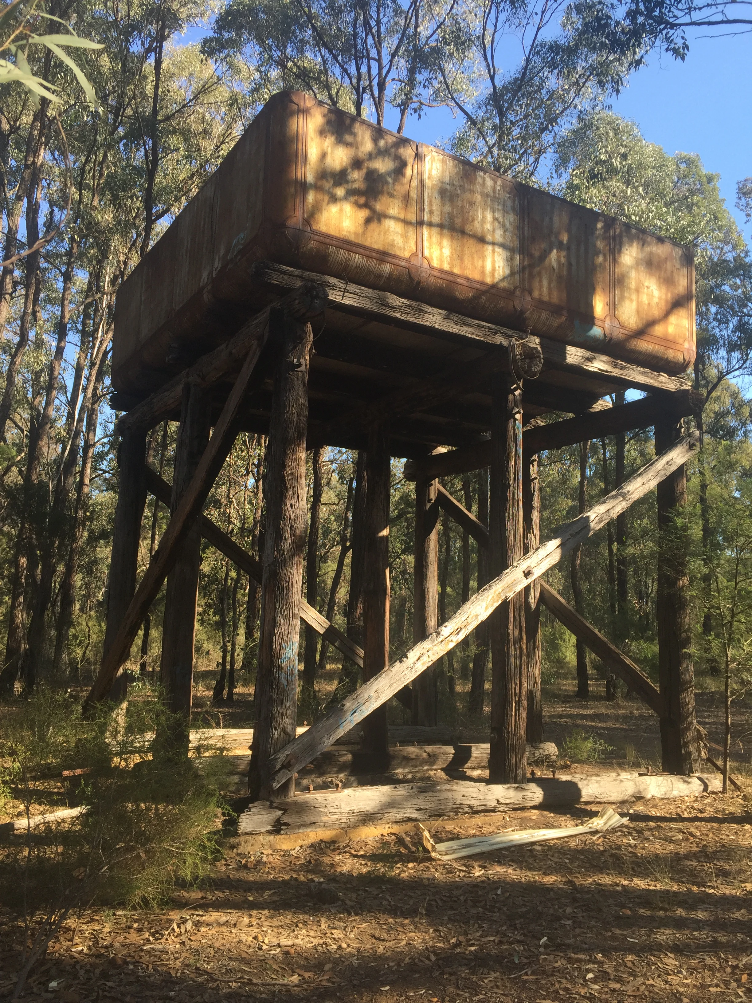
A weathered, metal water tank sits on a tall, wooden frame structure within a wooded area with trees surrounding it.
The remains of a historic water tower within the forest at Windsor Downs Nature Reserve.

Windsor Downs Nature Reserve history and protected-area timeline

Windsor Downs Nature Reserve occupies land that was historically part of the country of the Darug Aboriginal people. Archaeological evidence within the reserve includes Aboriginal campsites and stone tools, indicating a long pre-colonial human presence connected with the broader Cumberland Plain landscape.

The land was later acquired by the Riverstone Meatworks and used for more than a century, during which it was substantially cleared and managed as grazing land for cattle. Remnants of this period, including an old water tower and concrete water troughs, remain as visible features of the reserve today.

In the late 1980s, shortly before the Riverstone Meatworks closed, the property was sold to the New South Wales National Parks and Wildlife Service. The reserve was officially established on 7 September 1990 as a state-protected nature reserve. In more recent history, the reserve was severely affected by a major bushfire on 10 September 2013, which was subsequently attributed to a power line brought down by strong winds.

Windsor Downs Nature Reserve landscape and geographic character

Windsor Downs Nature Reserve lies on the gently undulating terrain of the Cumberland Plain, west of Sydney. The reserve does not rise into dramatic peaks or carved gorges; rather it occupies low, rolling ground at the edge of the Hawkesbury-related plain, with subtle variations driven primarily by changes in soil type rather than major topographic relief.

This variation in substrate shapes the visual character of the reserve. Where clay-rich soils dominate, the land carries open eucalypt forest with ironbarks reaching into the canopy above a grassy understorey. On the sandier soils, the forest gives way to a more open sclerophyll woodland dominated by Eucalyptus sclerophylla, with a different understorey structure and a lighter, more dappled feel. Former grazing paddocks, now released from grazing pressure, support patches of regenerating hakea scrub that add further textural variety to the landscape.

The reserve's setting is also strongly defined by its urban context. Suburban edges meet the woodland margin in several directions, and the surviving vegetation has meaning precisely because it is surrounded by developed land rather than continuous bush. The old meatworks water tower, still standing within the reserve, anchors the scene with a reminder of how thoroughly the original woodland was cleared and how partial its recovery remains.

Windsor Downs Nature Reserve ecosystems, habitats, and plant life

The ecological identity of Windsor Downs Nature Reserve is inseparable from the broader identity of the Cumberland Plain Woodland, the critically endangered ecological community of grassy and shrubby eucalypt woodland that once stretched across the western Sydney basin. The reserve preserves a representative fragment of this community in a region where the vast majority of the original woodland has been cleared for housing, roads, and pasture.

Vegetation within the reserve is highly correlated with soil conditions. Ironbark open forests of Eucalyptus fibrosa and Eucalyptus sideroxylon prefer heavier clay substrates and form the dominant forest type across parts of the reserve. Where soils become sandier, Eucalyptus sclerophylla woodlands take over, creating a structurally distinct habitat. On the former grazing areas that were stripped and compacted during the meatworks era, the vegetation community is now in a more seral, recovering state, dominated by sub-mature hakeas and a thinning canopy of regenerating eucalypts.

Among the reserve's notable ecological contributions is its population of threatened plant species. Dillwynia tenuifolia, Persoonia nutans, Pultenaea parviflora, and Grevillea juniperina all survive here, lending the reserve botanical significance well beyond its small footprint. The combination of intact mature woodland, regenerating areas, and a number of microhabitats gives the reserve considerable ecological complexity for its size and supports a diverse community of dependent animals.

Windsor Downs Nature Reserve wildlife and species highlights

Windsor Downs Nature Reserve supports a surprisingly rich assemblage of native fauna for a small, suburban-edge reserve. Eastern grey kangaroos are a regular and conspicuous presence, often seen grazing in the more open grassy patches. Swamp wallabies use the denser shrubby areas, while arboreal mammals such as sugar gliders, common brushtail possums, and common ringtail possums inhabit the older hollow-bearing trees.

The bird community is one of the reserve's strong points. At least sixty-eight species have been recorded, including familiar woodland birds such as yellow-tailed black cockatoos, sulphur-crested cockatoos, and laughing kookaburras. The reserve holds particular significance for two birds of conservation concern: the endangered regent honeyeater, which is known to reside here, and possibly one of the last populations of red-capped robins persisting within greater Sydney.

Reptiles are also well represented. Goannas patrol the woodland floor and fallen timber, eastern brown snakes and red-bellied black snakes occur in the reserve, and blue-tongued lizards are commonly encountered in more open areas. Together, the mammals, birds, and reptiles reflect the reserve's ability to support a functioning, if small, woodland ecosystem in close proximity to large urban populations.

Windsor Downs Nature Reserve conservation status and protection priorities

Windsor Downs Nature Reserve is managed as a strict nature reserve under IUCN Category Ia by the NSW National Parks and Wildlife Service, a designation that reflects its conservation intent and the level of protection from incompatible uses. Its primary conservation value lies in protecting a surviving example of Cumberland Plain Woodland, a critically endangered ecological community whose original extent across western Sydney has been almost entirely lost to urban expansion.

The reserve is significant for safeguarding populations of threatened species on both sides of the plant and animal divide. It supports threatened flora such as Persoonia nutans and Dillwynia tenuifolia, and provides habitat for the endangered regent honeyeater, one of Australia's most imperilled woodland birds. As such, the reserve acts as a small but important refugium for species that have disappeared from much of the surrounding landscape.

The 2013 bushfire, caused by a windblown power line, illustrates the conservation challenges facing small reserves embedded in urban and peri-urban environments, where external infrastructure and edge effects create ongoing risks. Even so, the reserve stands as a working example of how remnant native vegetation on the Cumberland Plain can be protected, managed, and connected to broader biodiversity outcomes for western Sydney.

Windsor Downs Nature Reserve cultural meaning and human context

Windsor Downs Nature Reserve occupies land with deep and layered cultural connections. The area lies within the traditional country of the Darug people, and the presence of recorded Aboriginal campsites and stone tools within the reserve points to a long history of Aboriginal land use across the Cumberland Plain before European colonisation.

The more recent cultural layer is tied to the Riverstone Meatworks. For well over a century the property operated as part of a large-scale meat processing and pastoral enterprise that shaped the economy and settlement pattern of western Sydney. While the meatworks has long since closed, the surviving structures inside the reserve, including the water tower and concrete water troughs, give the landscape a distinctive industrial pastoral character that overlays its ecological identity. Together these layers make Windsor Downs a place where Aboriginal heritage, early colonial pastoral use, and modern nature conservation intersect in a relatively compact area.

Top sights and standout views in Windsor Downs Nature Reserve

Windsor Downs Nature Reserve is highlighted by its role as one of the few surviving remnants of Cumberland Plain Woodland, an ecological community that is essentially exclusive to the western Sydney region and is now critically endangered. This single defining feature underpins much of the reserve's conservation value and ecological identity.

Beyond its vegetation, the reserve offers a remarkable concentration of biodiversity for its size, including eastern grey kangaroos, a diverse reptile community, and at least sixty-eight recorded bird species. The presence of the endangered regent honeyeater gives the reserve national conservation significance, while reminders of its past as Riverstone Meatworks grazing land, including the old water tower, give it a distinctive cultural character unusual for a small nature reserve.

Best time to visit Windsor Downs Nature Reserve

Windsor Downs Nature Reserve can be visited throughout the year, with different seasons highlighting different aspects of the woodland. Spring is typically the most rewarding period for wildflowers and for hearing the range of woodland birds in full breeding activity. Autumn brings cooler, more comfortable conditions and stable weather for walking the reserve and observing wildlife.

Summer in western Sydney can be very hot, and visitation during the warmest parts of the day is generally less comfortable, though early mornings and cooler evenings can still produce good wildlife sightings. Winter days are usually mild and clear, offering calm conditions for viewing the woodland structure and spotting kangaroos and birds. Visitors should be aware that fire risk can affect access and walking conditions, particularly during hotter, drier periods, after events such as the 2013 bushfire that affected the reserve.

Monthly climate preview

Long-term representative records of annual temperature and precipitation rhythm

Windsor Downs Nature Reserve Climate and Monthly Temperature Normals

Windsor Downs Nature Reserve records measurable shifts in long-term temperature and precipitation across representative coordinate sampling. Reviewing the complete twelve-month climatology profile reveals detailed patterns in monthly averages.
Annual mean16 °C
9 °C23 °C
Jan23°
Feb22°
Mar19°
Apr16°
May13°
Jun10°
Jul
Aug10°
Sep14°
Oct17°
Nov19°
Dec21°
Warmest month
January

23.1 °C

Coolest month
July

9.1 °C

Wettest month
February

4.7 mm/day

Driest month
July

1.7 mm/day

Park location guide

Geography guide, regional context, and park location map for Windsor Downs Nature Reserve

Windsor Downs Nature Reserve park geography, regions, and map view in Australia

Understand where Windsor Downs Nature Reserve sits in Australia through a broader geographic reading of the surrounding landscape, nearby location context, and its mapped position within the national park landscape.

How Windsor Downs Nature Reserve fits into Australia

Australia is a constitutional monarchy and federal parliamentary democracy comprising six states and ten territories. With a population of nearly 28 million, it is one of the world's most urbanised countries, with most people concentrated on the eastern seaboard. The country has a high Human Development Index and is known for its cultural diversity, ancient Aboriginal heritage, and unique wildlife.

Wider geography shaping Windsor Downs Nature Reserve in Australia

Australia occupies the entire Australian continent, the island of Tasmania, and numerous smaller islands. It is the world's flattest and driest inhabited continent, featuring vast deserts in the interior (the Outback), tropical rainforests along the eastern coast, and a coastline bordering the Indian and Pacific Oceans.

Map view of Windsor Downs Nature Reserve

Use this park location map to pinpoint Windsor Downs Nature Reserve in Australia, understand its exact geographic position, and read its mapped placement within the surrounding landscape more clearly.

Pigeon | © OpenStreetMap contributors

Location context for Windsor Downs Nature Reserve

New South Wales

Visualizing endangered woodland habitats, ironbark forests, and protected terrain

Windsor Downs Nature Reserve Landscape and Scenery Photography

Visual records reveal the distinctive ironbark forests, open sclerophyll woodlands, and undulating terrain of Windsor Downs Nature Reserve. Examining field photographs helps visitors understand the fragile lowland ecology and rare plant communities surviving amid the western Sydney urban fringe.

A weathered, metal water tank sits on a tall, wooden frame structure within a wooded area with trees surrounding it.

Park atlas

Compare adjacent lowland woodland reserves and regional conservation areas

Exploring Parks Near Windsor Downs Nature Reserve and Surrounding Protected Landscapes

Browsing other protected areas near Windsor Downs Nature Reserve reveals broader ecological patterns across the western Sydney lowlands. Comparing these connected woodland remnants provides valuable context on regional conservation challenges and surviving native habitats.
National parkAustralia
About 7.5 km away#1 closest

Northeast

Scheyville National Park: An Australian National Park's Mapped Protected Landscape and Regional Geography

Explore the protected boundaries and natural terrain of this park.

Scheyville National Park represents a vital protected area within Australia, offering a unique lens for geographic exploration. As a national park, its boundaries and landscape characteristics are essential for understanding its place in the regional geography. This content facilitates structured discovery of its natural terrain and mapped extent, providing foundational context for atlas-based learning about Australia's protected lands.

Area
9.2 km²
Established
1996
IUCN
V
Relief
Upland
Nature reserveNew South Wales
About 9.6 km away#2 closest

West

Agnes Banks Natural Area Nature Reserve and Geological Landscape in New South Wales

Rare inland sand dunes and native flora habitats

The Agnes Banks Natural Area preserves an ancient, wind-reworked sand deposit that supports coastal-style woodland communities far from the ocean. This site serves as a crucial ecological link within the Cumberland Plain, offering significant value for studying sand-dune evolution, geological history, and rare flora species unique to this protected landscape in New South Wales.

Established
1999
Relief
Lowland
Scope
Terrestrial
Water
Minor water
National parkAustralia
About 13 km away#3 closest

Northeast

Cattai National Park: Australia's Premier Colonial Heritage Protected Landscape

Mapped riverfront geography and historical Australian park context.

Cattai National Park represents a vital entry in Australia's atlas of protected areas, offering unparalleled insight into the nation's early colonial history alongside its natural riverine landscapes. The park's designation as a national park highlights its importance in preserving not only the unique geography of the Hawkesbury River floodplain but also significant historical sites like the Hope Farm Mill, Australia's oldest industrial site. Exploring Cattai National Park allows for a deep dive into mapped protected boundaries and the layered cultural and natural terrain of the Sydney region.

Area
4.24 km²
Established
1992
IUCN
II
Access
Easy access
State or regional parkNew South Wales
About 14 km away#4 closest

West

Yellomundee Regional Park: Mapped Escarpment Boundaries and Nepean River Geography

A significant bushland reserve in New South Wales, Australia

Yellomundee Regional Park serves as a protected bushland buffer on the Blue Mountains escarpment, where ridge topography meets the Nepean River. With a landscape largely untouched by human development, this reserve offers a window into the natural bushland ecosystems and riverine corridors of the Great Dividing Range in New South Wales. Use this atlas to visualize the park's ridgelines, gullies, and vertical transition from mountain slopes to river valley flats.

Area
4.85 km²
Established
2000
IUCN
V
Relief
Mountain
National parkNew South Wales
About 18 km away#5 closest

North

Wollemi National Park: Mapping Australia's Protected Natural Landscape in New South Wales

Detailed geographic context and protected area exploration.

Wollemi National Park is a critical component of New South Wales' protected natural areas, offering rich opportunities for geographic discovery. This national park provides a distinct focus for understanding the mapped terrain and regional landscape context of Australia. Explore its position within New South Wales, uncovering the details that define its unique protected status and natural geography for dedicated atlas exploration.

Area
5,017.03 km²
Established
1979
IUCN
Ib
Relief
Mountain
State or regional parkNew South Wales
About 22 km away#6 closest

South

Western Sydney Parklands: Mapped Protected Landscapes and Regional Geography

An expansive 27-kilometre urban corridor in New South Wales

Western Sydney Parklands stands as one of the most significant urban park systems in Australia, connecting numerous recreational precincts across a unique linear geography. This protected area preserves rare Cumberland Plain Woodland while serving as a vital hydrological link within the Greater Western Sydney landscape. Discover the detailed topography, ridgeline vistas, and ecological structure that define this metropolitan reserve's 27-kilometre span.

Area
52.8 km²
Established
1968
Visitors
790K annual
Relief
Lowland
Nature reserveNew South Wales
About 23 km away#7 closest

Southeast

Bidjigal Reserve: Protected Sandstone Landscapes and Cultural History in Sydney

Nature reserve featuring rare forest remnants and creek corridors

Spanning 186 hectares, Bidjigal Reserve acts as an intact bushland enclave within Sydney, New South Wales. The landscape transitions from suburban boundaries into diverse terrain including sandstone-based gullies, ridge formations, and remnants of Blue Gum High Forest. This area provides critical ecological habitat and protects ancient Aboriginal habitation sites, offering a distinct study in urban-adjacent wilderness and geological significance.

Area
1.86 km²
Established
2004
Relief
Lowland
Scope
Terrestrial
National parkNew South Wales
About 23 km away#8 closest

East

Berowra Valley National Park: A National Park in New South Wales with Detailed Geographic Mapping

Explore its mapped boundaries and regional landscape context.

Delve into Berowra Valley National Park, a protected area situated in New South Wales, Australia. This entry provides essential geographic context, focusing on its mapped boundaries and the specific natural landscape it encompasses. It serves as a key resource for understanding the park's role within the broader regional atlas and its distinct protected terrain.

Area
38.84 km²
Established
2012
IUCN
II
Relief
Upland

Common questions about visiting, size, designation, and location context for Windsor Downs Nature Reserve

Windsor Downs Nature Reserve FAQs for park facts, access, geography, and protected area context

Find quick answers about Windsor Downs Nature Reserve, including protected-area facts, park geography, trail and visitor context, and how the park fits into its surrounding country and regional landscape.
MoriAtlas Explorer

Continue Your Protected Areas Search Across the Global Atlas

Deepen your exploration by continuing the structured search for national parks and protected areas worldwide. Utilize the comprehensive filtering capabilities to compare different conservation landscapes and refine your understanding of global park geography. Discover more about the distribution and characteristics of protected natural areas.

Global natural geography