
Mori Atlas logo
Nature reserveWolfsgrund

Mapping the ecological diversity of inland dunes and alder swamp forest corridors

Wolfsgrund Nature Reserve and Protected Heathland Landscape in Lower Saxony, Germany

(Naturschutzgebiet Wolfsgrund)

Wolfsgrund sits as a significant protected nature reserve within the district of Rotenburg, Lower Saxony, where the Everser Bach stream cuts through a distinct inland dune landscape. This area preserves a rare mosaic of habitats ranging from dry broom heath and moist peat moss depressions to sheltered alder swamp forests. The terrain serves as a vital ecological enclave, showcasing glacial-era sandy deposits and a sharp gradient of wetland and dryland plant communities within a largely cultivated regional geography.

heathlandinland dunemirewet heathdry heathalder swamp forest
A flat-style digital illustration of a park scene featuring birch trees in the foreground, a wooden bench overlooking a winding path, and a waterfall flowing down a cliff in the background.

Wolfsgrund

Nature reserve

Park overview

Structured park overview, official facts, and landscape profile for Wolfsgrund

Wolfsgrund park facts, protected area profile, and essential visitor context

Review the core facts for Wolfsgrund, including designation, size, terrain, visitor scale, habitats, and operating context in one park-focused overview.

About Wolfsgrund

Wolfsgrund is a small but ecologically rich nature reserve in the northern German countryside, situated in the district of Rotenburg (Wümme) in Lower Saxony. Its setting between the towns of Rotenburg (Wümme) and Verden (Aller) places it within a gently undulating part of the North German plain, an area historically shaped by glacial deposits that have weathered into inland dunes, sandy ridges, and shallow valleys cut by small streams.

The reserve takes its character from this geological foundation. A narrow valley of the Everser Bach south of the village of Eversen forms the western part of the area, framed by an inland dune that rises to roughly 37 metres above sea level. Where the stream deposits fine sediments, the valley floor supports alder swamp woodland, a wet forest community adapted to fluctuating groundwater. The slopes and ridges of the dune are clothed with mixed woodland, while the higher sandy plateaus at the northern end of the reserve have escaped intensive forest planting and now carry an open heath landscape.

What makes Wolfsgrund particularly significant is the combination of three distinct heath communities within a compact area. On the driest, most nutrient-poor sands, broom heath with heather (Calluna vulgaris) dominates, while crowberry and purple moor grass appear where soil moisture rises slightly. In depressions where water accumulates, moist heath communities develop, featuring cross-leaved heath (Erica tetralix) alongside broom heath and several species of Sphagnum moss. This dune-and-heathland mosaic places Wolfsgrund among the larger connected heath reserves in the district outside the better-known Lüneburger Heide.

The area is not isolated from broader European conservation goals. The reserve is part of the Natura 2000 network, with the overlapping FFH area covering the great majority of the protected land. This dual status as a national nature reserve and an EU-level habitat site underlines its importance for protecting threatened inland dune and heath habitats in central Lower Saxony. Walking paths cross the area and a viewing platform along the margin offers visitors a structured way to experience the heath and dune landscape.

Quick facts and research context for Wolfsgrund

Wolfsgrund is classified under IUCN Category IV as a Habitat/Species Management Area and carries the German designation NSG LÜ 066. The reserve covers roughly 50 hectares, of which about 45 hectares form a contiguous FFH (Fauna-Flora-Habitat) area. It sits at elevations between approximately 28 and 37 metres above sea level within the district of Rotenburg (Wümme). Established on 26 February 1977 and expanded to its current extent on 1 December 2017, it is administered by the Niedersächsischer Landesbetrieb für Wasserwirtschaft, Küsten- und Naturschutz (NLWKN) under the oversight of the district of Rotenburg (Wümme).

Protection and recognition

Examine documented protection status and official Natura 2000 recognition for Wolfsgrund.

Wolfsgrund Protection Status, Natura 2000 Designation, and International Records

Wolfsgrund maintains official recognition through recorded Natura 2000 designations and baseline data entries. Review structured administrative records and verified protection frameworks associated with the protected area.
Park context

Deeper park guide and search-rich context for Wolfsgrund

Wolfsgrund history, landscape, wildlife, and travel context

Explore Wolfsgrund through its history, landscape character, ecosystems, wildlife, conservation priorities, cultural context, and seasonal travel timing in a structured park guide built for atlas discovery and search intent.

Why Wolfsgrund stands out

Wolfsgrund is best known for its inland dune landscape and the mosaic of dry, moist, and wet heath habitats that developed on it. The reserve preserves alder swamp forest along the Everser Bach as well as broom heath, crowberry, moor grass, and bell heather communities growing in a tight ecological gradient across the dune. It is regarded as one of the more substantial connected heath reserves in the area outside the Lüneburger Heide, giving it regional significance for heathland conservation.
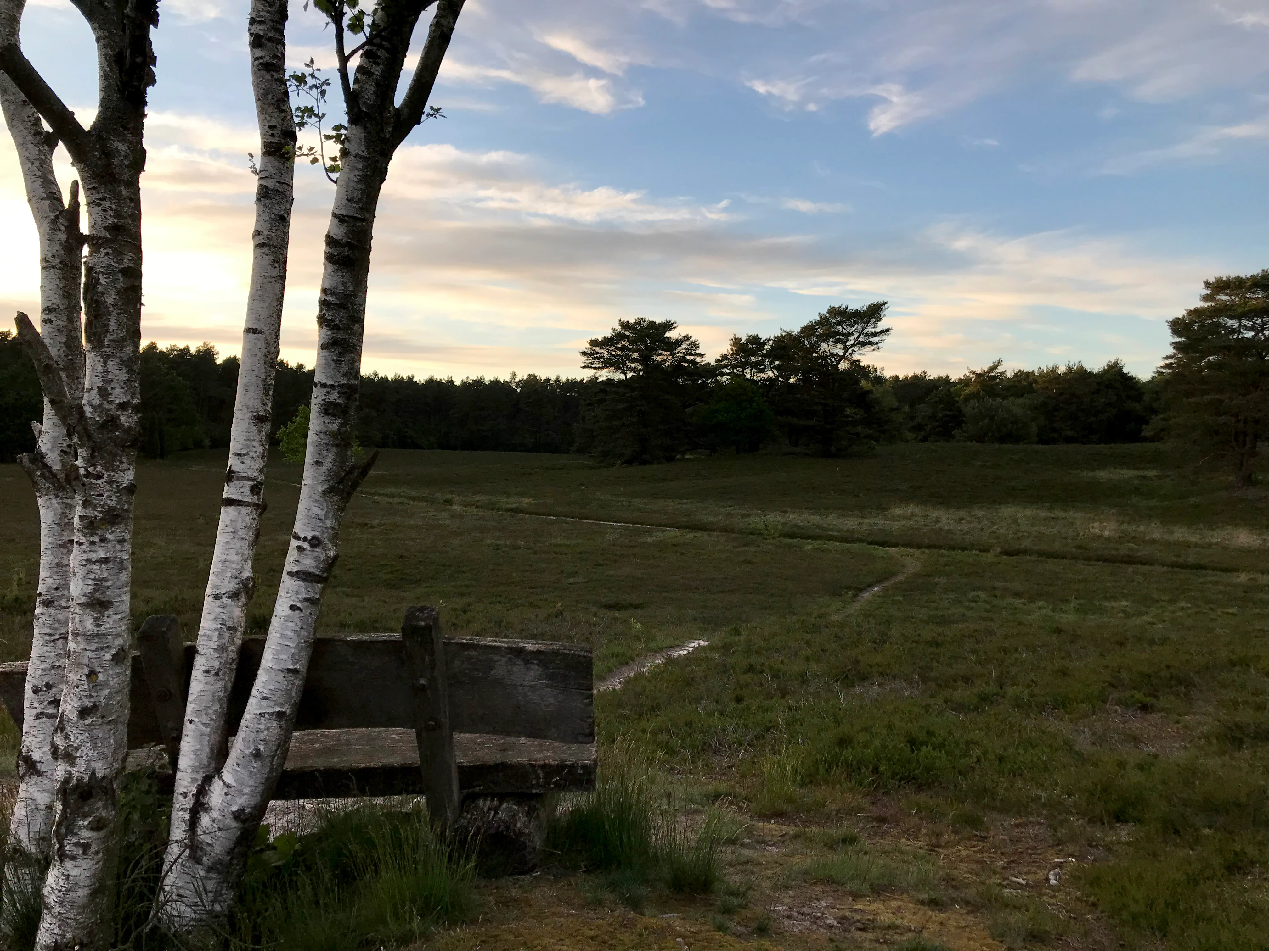
A rustic wooden bench sits in the foreground under white birch trees, looking out over an expansive, low-lying heathland under a cloudy sky.
A peaceful bench overlooking the open heath landscape of Wolfsgrund.

Wolfsgrund history and protected-area timeline

The Wolfsgrund area has been formally protected as a nature reserve since 26 February 1977, when the district of Rotenburg (Wümme) designated it under the designation NSG LÜ 066. At that time the reserve covered roughly 45 hectares.

For several decades the site remained close to its original footprint. On 1 December 2017 the protected area was officially expanded to its present size of approximately 50 hectares, consolidating and extending the protection of the inland dune and adjacent heathland. Throughout this period, the Niedersächsischer Landesbetrieb für Wasserwirtschaft, Küsten- und Naturschutz (NLWKN) has served as the state-level authority, with the district of Rotenburg (Wümme) acting as the responsible lower-level nature conservation office.

The fact that a substantial part of the area was also classified as a Fauna-Flora-Habitat site under the EU Habitats Directive reflects a broader modernization of the site's conservation framework, embedding the older German nature reserve within the contemporary Natura 2000 network.

Wolfsgrund landscape and geographic character

The landscape of Wolfsgrund revolves around a small inland dune and the narrow stream valley of the Everser Bach. The dune represents an older sand deposit typical of the glacial and periglacial processes that shaped much of northern Germany, and it rises only modestly above its surroundings, reaching between roughly 28 and 37 metres above sea level. Despite its limited relief, the dune creates a striking ecological contrast through its sandy, free-draining upper surfaces and its more sheltered, moister flanks.

The Everser Bach has cut a shallow, narrow valley through part of this dune landscape, depositing finer sediments and creating conditions for wetland forest. Around this stream corridor the terrain transitions from densely wooded valley bottom to open, exposed sandy plateaus. Bordered by agricultural fields and forests on its western and northeastern edges, the reserve forms a compact enclave of semi-natural habitat within a largely cultivated region. Public roads frame parts of the reserve, and walking trails, together with a viewing platform at the margin, allow the dune, heath, and stream valley landscape to be observed as a single connected scene.

Wolfsgrund ecosystems, habitats, and plant life

The ecological identity of Wolfsgrund rests on a tight mosaic of woodland, heath, and mire habitats, all driven by the local interplay between sandy substrate and groundwater. In the valley of the Everser Bach, periodically waterlogged fine soils support alder swamp woodland (Erlenbruchwald), a wet forest type of strong conservation interest in central Europe.

The dune slopes and most of the higher sandy areas are wooded, but the most ecologically distinctive vegetation occurs on the open plateaus, where historic land use has produced a heath landscape. Dry sandy ground carries broom heath communities dominated by common heather, with crowberry and purple moor grass marking slightly moister microsites. In depressions and shallow basins a moist heath community has established, marked by the presence of cross-leaved heath alongside broom heath and various Sphagnum peat mosses. This combination of dry, mesic, and wet heath within a single small area is one of the reserve's defining ecological features.

Wolfsgrund wildlife and species highlights

Wolfsgrund is primarily valued for its habitats rather than for specific charismatic species, but its heath and mire complex supports the faunal communities typical of inland dune and wet heathland in Lower Saxony. Such landscapes tend to harbour specialised invertebrates, including solitary bees, sand wasps, and a range of moths and other insects tied to heather and moor grass.

The mosaic of wet woodland, heath, and open sand also provides varied conditions for ground-nesting birds, reptiles that favour warm sandy exposures, and amphibians associated with the wetter ground along the Everser Bach. The reserve's official recognition as part of the Natura 2000 network reflects its role in supporting these habitat-specialist communities at a regional scale.

Wolfsgrund conservation status and protection priorities

The conservation significance of Wolfsgrund lies in the protection of an inland dune with a connected heath and mire landscape, an increasingly rare combination in central Lower Saxony. The reserve's dual status as a Naturschutzgebiet under German law and as a Fauna-Flora-Habitat area under the EU Habitats Directive places it firmly within both national and European conservation frameworks.

Its inland dune with dry, moist, and wet heath communities is broadly analogous to habitats for which the Lüneburger Heide is better known, and Wolfsgrund provides a smaller, complementary stronghold outside that major heath region. By buffering the area from surrounding agricultural and forestry pressures and by formally protecting the dune topography and its associated vegetation patterns, the reserve safeguards the ecological processes that maintain open heath in the face of nutrient enrichment, scrub encroachment, and woodland expansion. The 2017 enlargement of the reserve further strengthened this role by extending protection to additional heathland areas surrounding the original core.

Wolfsgrund cultural meaning and human context

Wolfsgrund lies in a part of Lower Saxony where small communities and agricultural land use have shaped the surrounding countryside for centuries. The reserve's place names, including the stream referred to as the Everser Bach and the village of Eversen, reflect this long-standing rural settlement pattern. The area represents a fragment of the traditional heath and wetland landscape that once covered much larger portions of the North German plain, preserved here in a way that connects contemporary conservation with the region's older land-use history.

Top sights and standout views in Wolfsgrund

Wolfsgrund's strongest identity points are its inland dune topography, the connected mosaic of dry broom heath, moist heath, and peat-moss-dominated wet heath, and the contrasting alder swamp forest along the Everser Bach. Its protected status under both German and EU law, combined with its recognition as one of the larger connected heath reserves outside the Lüneburger Heide, gives it clear regional conservation significance despite its modest size.

Best time to visit Wolfsgrund

Late summer and early autumn are traditionally the most rewarding season to experience Wolfsgrund, when the broom heath on the dune plateaus is in bloom and the heathland takes on a richer purple tone. Spring can be attractive for observing renewed growth in the valley woodland and the wet heath communities, while autumn brings cooler, often clearer weather suitable for longer walks along the reserve's trails. Visiting in early morning or late afternoon tends to offer the best light over the open dune and heath areas and a higher chance of encountering wildlife typical of these habitats.

Monthly climate preview

Long-term representative monthly temperature and precipitation rhythm in Lower Saxony

Wolfsgrund Climate Normals and Measured Annual Temperature Patterns

Wolfsgrund exhibits a measured annual climate cycle spanning from sub-zero winter minimums to warm summer maximums alongside consistent daily precipitation records. Reviewing the complete monthly profile provides essential context for understanding long-term regional weather variations.
Annual mean9 °C
1 °C18 °C
Jan
Feb
Mar
Apr
May13°
Jun16°
Jul18°
Aug18°
Sep14°
Oct
Nov
Dec
Warmest month
July

18.1 °C

Coolest month
January

0.7 °C

Wettest month
July

2.5 mm/day

Driest month
April

1.4 mm/day

Park location guide

Geography guide, regional context, and park location map for Wolfsgrund

Wolfsgrund park geography, regions, and map view in Germany

Understand where Wolfsgrund sits in Germany through a broader geographic reading of the surrounding landscape, nearby location context, and its mapped position within the national park landscape.

How Wolfsgrund fits into Germany

Germany is a federal republic in Western and Central Europe with a population of over 83 million across sixteen constituent states. It is Europe's largest economy by nominal GDP and a major global exporter and importer. The capital is Berlin, and the country borders Denmark, Poland, Czech Republic, Austria, Switzerland, France, Luxembourg, Belgium, and the Netherlands.

Wider geography shaping Wolfsgrund in Germany

Germany is located in Western and Central Europe, spanning 357,022 km². It borders Denmark to the north, Poland and the Czech Republic to the east, Austria and Switzerland to the south, and France, Luxembourg, Belgium, and the Netherlands to the west. The country has coastlines on the Baltic Sea and North Sea to the north, with the Alps located in the southern region.

Map view of Wolfsgrund

Use this park location map to pinpoint Wolfsgrund in Germany, understand its exact geographic position, and read its mapped placement within the surrounding landscape more clearly.

Pigeon | © OpenStreetMap contributors

Location context for Wolfsgrund

Landkreis Rotenburg (Wümme)Lower Saxony
Recorded earthquake history

Examine the Recorded Earthquake History Associated With Wolfsgrund

Discover a comprehensive collection of historical seismic records documented near the Wolfsgrund nature reserve. This catalogue allows for the exploration of event data and epicentre proximity within the region, providing a clearer understanding of local seismic history through a curated, atlas-focused perspective.

Wolfsgrund Earthquake History

Catalogued events

3 events

Strongest magnitude

Magnitude 4.5

Most recent event

Jul 15, 2005

This history includes earthquakes recorded inside the park or within 50 km of its borders

Explore detailed imagery of inland dune topography, wet heath matrices, and stream valleys.

Wolfsgrund Photos and Landscape Scenery: Visualizing Protected Heath Habitats

Visual documentation of Wolfsgrund reveals the intricate ecological gradients across its protected inland dunes and stream valleys. Examining these curated photographic records provides clear insight into the complex terrain, rare heathland vegetation, and distinctive protected landscape character.

A rustic wooden bench sits in the foreground under white birch trees, looking out over an expansive, low-lying heathland under a cloudy sky.

Park atlas

Compare surrounding regional nature reserves, inland dune terrain, and protected heathlands.

Explore Other Parks Near Wolfsgrund And Connected Protected Landscapes

Browsing other protected areas near Wolfsgrund reveals related heathland and valley ecosystems across the surrounding region. Comparing adjacent nature reserves provides deeper geographic context for northern German lowland conservation.
Nature reserveLower Saxony
0.8 km away#1 closest

Southeast

Wedeholz Nature Reserve: Geographic Overview of Lower Saxony Protected Forest Landscapes

Ancient oak forests, Geest terrain, and protected wetland habitats

Wedeholz represents a dense forest conservation area in Lower Saxony, defined by its mature oak and beech communities. The reserve terrain transitions from dry sandy Geest soils to delicate pine swamp forests and floating bogs, supporting a high density of deadwood-dependent species and woodland biodiversity within a compact, protected boundary.

Area
1.83 km²
Established
2019
IUCN
IV
Relief
Upland
Nature reserveLower Saxony
About 5 km away#2 closest

West

Waller Moor Nature Reserve: Geographic Context and Protected Landscape Profile

Mapping raised bog restoration in the Verden district of Lower Saxony

Waller Moor represents a focused effort to restore degraded peatland within Lower Saxony. By integrating grassland buffers and small pond habitats, the reserve preserves a specific lowland bog character. Its placement near the Spanger Holz woodland highlights the interplay between protected core habitats and managed regional terrain in northern Germany.

Area
0.25 km²
Established
1985
IUCN
IV
Relief
Lowland
Nature reserveNiedersachsen
About 5.1 km away#3 closest

Southwest

Waller Flachteiche Nature Reserve: Exploring the Geography of Protected Landscapes in Niedersachsen

Mapped habitats of a former sand quarry wetland

Waller Flachteiche is a state-recognized nature reserve covering over 22 hectares of sandy, lowland terrain in Germany. The protected area offers a look at a recovered industrial site, where periodically drying ponds and diverse scrubland create a specialized habitat for rare amphibians and wetland flora. Its defined boundaries highlight a critical Natura 2000 component within the broader Niedersachsen region.

Area
0.227 km²
Established
2018
IUCN
IV
Nature reserveLandkreis Rotenburg (Wümme)
6.2 km away#4 closest

Northeast

Wümmeniederung mit Rodau, Wiedau und Trochelbach: Protected Wetland and Heath Landscape

Regional geography and floodplain connectivity in Landkreis Rotenburg

This nature reserve protects a sprawling lowland landscape characterized by the Wümme, Rodau, Wiedau, and Trochelbach rivers. The terrain features a mosaic of near-natural meandering streams, species-rich wet meadows, and rare raised bog remnants, providing a comprehensive overview of northern German lowland ecology.

Area
28.96 km²
Established
2020
IUCN
IV
Relief
Lowland
Nature reserveLower Saxony
12 km away#5 closest

North

Stellmoor und Weichel: Geographic Profile of a Lower Saxony Nature Reserve

Protected geest woodlands and peat-bog mosaic landscapes

Examine the territorial boundaries and ecological features of Stellmoor und Weichel. Located on the flat geest ridge of Northern Germany, this reserve maps the transition from managed deciduous woodland to complex mire, willow thicket, and bog-fringe water systems, maintaining a long-standing natural forest reserve status.

Area
2.18 km²
Established
2018
IUCN
IV
Nature reserveLower Saxony
About 13 km away#6 closest

Southeast

Verdener Moor Nature Reserve: Geographic Atlas and Protected Area Context

Preserving raised bog ecosystems in Lower Saxony, Germany

Located in the municipality of Kirchlinteln, Verdener Moor functions as a protected nature reserve that demonstrates lowland peatland conservation. The landscape features a distinct mosaic of open water resulting from historical peat extraction, wet heath, and rewilded forest edges. This site offers valuable insight into the restoration of bog habitats through rewetting and bush removal within the broader geography of Lower Saxony.

Area
0.91 km²
Established
1989
IUCN
IV
Relief
Lowland
Nature reserveLower Saxony
About 14 km away#7 closest

North

Wiestetal Nature Reserve: Mapping the Wieste Stream and Riparian Habitat Corridor

Protected floodplain geography in Lower Saxony, Germany

Wiestetal acts as a critical nature reserve between Mulmshorn and Ottersberg, protecting the unique ecological character of the Wieste lowland stream. The area is defined by its meandering water channels, flooded sand quarry ponds, and diverse forest edges that sustain local biodiversity. This protected landscape offers a detailed look at the interplay between glacial sand deposits and the vibrant aquatic ecosystems of Northern Germany.

Area
3.82 km²
Established
2013
IUCN
IV
Relief
Upland
Nature reserveLandkreis Rotenburg (Wümme)
About 16 km away#8 closest

North

Westliches Borchelsmoor Nature Reserve: Geographic Profile and Protected Bog Landscape

A preserved peatland fragment in the Landkreis Rotenburg district.

Located in northern Lower Saxony, Westliches Borchelsmoor represents a significant remnant of the historical Borchelsmoor raised bog. The reserve showcases a complex topography of old drainage lines and birch woodland, providing a clear window into the ecological transition of modified moorland. This site serves as a core component of the local wetland mosaic and offers valuable insights into ongoing peatland restoration and bog conservation.

Area
1.25 km²
Established
2010
IUCN
IV
Relief
Lowland

Common questions about visiting, size, designation, and location context for Wolfsgrund

Wolfsgrund FAQs for park facts, access, geography, and protected area context

Find quick answers about Wolfsgrund, including protected-area facts, park geography, trail and visitor context, and how the park fits into its surrounding country and regional landscape.
MoriAtlas Explorer

Continue Your Protected Areas Search Across the Global Atlas

Deepen your exploration by continuing the structured search for national parks and protected areas worldwide. Utilize the comprehensive filtering capabilities to compare different conservation landscapes and refine your understanding of global park geography. Discover more about the distribution and characteristics of protected natural areas.

Global natural geography