Mori Atlas logo
Nature reserveWolong National Nature Reserve

Analyzing the dramatic vertical elevation gradients and river valley systems of this Sichuan nature reserve.

Wolong National Nature Reserve: Mapped Protected Landscapes in the Qionglai Mountains

(Sichuan Wolong National Nature Reserve)

Wolong National Nature Reserve spans 200,000 hectares across the eastern flank of the Qionglai Mountains, creating a vital transitional belt between the Sichuan Basin and the Tibetan Plateau. This expansive protected area integrates deep river valleys and high-altitude forest ecosystems that serve as a primary stronghold for the giant panda. The landscape is defined by its rugged topography, reaching from 1,150 meters up to the peaks of Mount Siguniang, supporting a dense, tiered network of subalpine forests and bamboo resources.

giant panda habitatsubalpine forestsalpine meadowsmountain reserveQionglai MountainsSichuan wildlife

Wolong National Nature Reserve

Nature reserve

Park overview

Structured park overview, official facts, and landscape profile for Wolong National Nature Reserve

Wolong National Nature Reserve park facts, protected area profile, and essential visitor context

Review the core facts for Wolong National Nature Reserve, including designation, size, terrain, visitor scale, habitats, and operating context in one park-focused overview.

About Wolong National Nature Reserve

Wolong National Nature Reserve occupies a dramatic transition zone where the lowlands of the Sichuan Basin climb steeply into the high ridges of the Tibetan Plateau. Its roughly 200,000 hectares span the eastern Qionglai Mountains and the upper tributaries of the Min River, including the Pitiao, Zheng, Xi, and Zhong rivers, whose deeply incised valleys shape much of the landscape.

The reserve was established in 1963 on a much smaller footprint and expanded in 1975 to its current scale, becoming one of China's largest national nature reserves and the largest in Sichuan Province. In 1980 it joined the UNESCO Man and the Biosphere Programme network, and the same year partnered with WWF to establish the China Conservation and Research Center for the Giant Panda. Since then, Wolong has been central both to wild panda monitoring and to the science of captive breeding and reintroduction.

In 2021 the reserve was formally integrated into the Giant Panda National Park, a larger trans-regional protected system that consolidates key panda habitats across Sichuan. Wolong is also a recognized component of the UNESCO World Heritage Site for the Sichuan Giant Panda Sanctuaries, alongside Mount Siguniang and the Jiajin Mountains.

The local human geography is unusual within China's protected-area system. Because roughly 4,000 farmers and herders lived within the original reserve boundaries, the Wolong Special Administrative Region was created in 1983 to manage both ecological protection and local civic affairs through a single, dedicated administrative unit. This fusion of nature reserve and special administrative region has shaped governance, community relations, and conservation practice in the area for decades.

Quick facts and research context for Wolong National Nature Reserve

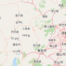
Wolong National Nature Reserve lies in southwestern Wenchuan County, Sichuan Province, on the eastern slopes of the Qionglai Mountains, not far from the provincial capital Chengdu, about 130 kilometers to the east.

Originally designated in 1963 at a much smaller scale, the reserve was expanded to roughly 200,000 hectares in 1975 and elevated to national status. It joined the UNESCO Man and the Biosphere Programme network in 1980, the same year the China Conservation and Research Center for the Giant Panda was established here in cooperation with WWF.

The reserve has long served as China's flagship giant panda conservation area, and it was included within the Giant Panda National Park when that system was created in 2021. It is also a listed component of the Sichuan Giant Panda Sanctuaries World Heritage Site.

Protection and recognition

Examine terrestrial protection scope, management frameworks, and official records.

Wolong National Nature Reserve Protection Status and Governance Data

Wolong National Nature Reserve maintains a documented terrestrial protection scope within its designated conservation boundaries. Structured administrative data outlines management parameters and official status records for this protected landscape.

Protection details

Protection scope
Terrestrial
Transboundary protection
No
Park context

Deeper park guide and search-rich context for Wolong National Nature Reserve

Wolong National Nature Reserve history, landscape, wildlife, and travel context

Explore Wolong National Nature Reserve through its history, landscape character, ecosystems, wildlife, conservation priorities, cultural context, and seasonal travel timing in a structured park guide built for atlas discovery and search intent.

Why Wolong National Nature Reserve stands out

Wolong is best known as one of the world's most important wild giant panda habitats and as the historical home of China's premier giant panda research and breeding program. Its rugged terrain, with elevations stretching from around 1,150 meters up to the peaks of Mount Siguniang at over 6,000 meters, supports a vertical sequence of forest types that creates ideal conditions for pandas and a wide range of other wildlife. The reserve is also widely recognized for its role in international conservation science. The China Conservation and Research Center for the Giant Panda, founded here in partnership with WWF in 1980, made Wolong a global symbol of efforts to understand and protect the species. The area is frequently cited together with Mount Siguniang and the Jiajin Mountains as part of the broader Sichuan Giant Panda Sanctuaries landscape.
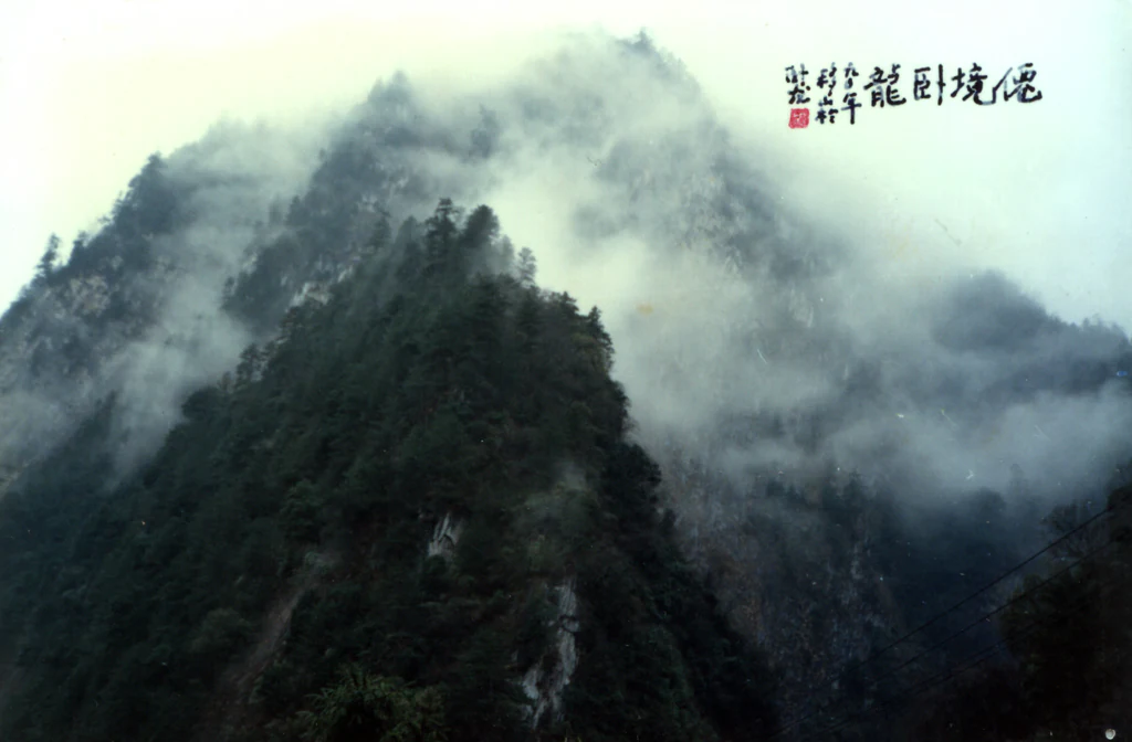
A steep mountain slope covered in dense forest partially obscured by thick white mist and low clouds.
Misty peaks in the Wolong National Nature Reserve

Wolong National Nature Reserve history and protected-area timeline

Wolong was first designated as a nature reserve in 1963, covering about 20,000 hectares. In 1975 the State Council significantly expanded the area to roughly 200,000 hectares and elevated its status, transforming Wolong into a flagship national nature reserve.

In 1980 the reserve joined the UNESCO Man and the Biosphere Programme network, and the same year partnered with WWF to establish the China Conservation and Research Center for the Giant Panda. By the early 1980s the practical challenges of protecting such a large area, while thousands of local residents still lived and farmed within its borders, led to a major administrative reorganization. In 1983 the Wolong Special Administrative Region was created within Wenchuan County, merging reserve management and local governance into a single body under joint provincial and national oversight, and later co-located with the reserve administration.

The reserve sustained severe damage during the May 2008 Wenchuan earthquake, which struck less than 20 kilometers from Wolong and posed serious risks to both wild pandas and research infrastructure. Notably, Wolong was initially excluded from China's standard pairing of a donor province with a hard-hit county. Local officials appealed to Hong Kong, which had recently received a pair of giant pandas, and this connection led to Hong Kong's substantial involvement in reconstruction projects at the reserve, ultimately funding around 23 panda-related and biodiversity conservation projects valued at roughly 1.42 billion yuan. By 2016, the Shenshuping base of the China Conservation and Research Center, the China Giant Panda Garden, had opened, marking the completion of these reconstruction efforts.

In 2021 Wolong was placed within the newly established Giant Panda National Park, a system that pools major panda habitats under coordinated management. Governance continued to evolve, with management responsibilities shifting to local and prefectural authorities and the establishment of a dedicated Wolong branch of the national park, culminating in 2026 with the formal dissolution of the reserve's standalone management bureau.

Wolong National Nature Reserve landscape and geographic character

Wolong lies within the transitional belt between the Sichuan Basin and the Tibetan Plateau, where mountains rise sharply from deeply cut valleys. The terrain is dominated by the eastern Qionglai Mountains, with the highest points reaching the peaks of Mount Siguniang at roughly 6,250 meters at the northwest edge of the reserve, while river valleys descend to about 1,150 meters at the southeastern margin, producing relative relief of more than 5,000 meters across a relatively short horizontal distance.

The reserve's hydrology is shaped by the upper Min River system. Its principal rivers, including the Pitiao, Zheng, Xi, and Zhong rivers, cut V-shaped valleys with steep gradients, feeding a dendritic network of tributaries that descends eastward toward the Sichuan Basin. This combination of high runoff, narrow valleys, and strong elevation drops gives the reserve substantial hydropower potential in addition to its ecological importance.

Wolong National Nature Reserve ecosystems, habitats, and plant life

The climate of Wolong falls within the broader Tibetan Plateau climate zone, characterized by cool, rainy summers and cold, dry winters, with a mean annual temperature near 10 degrees Celsius, abundant precipitation, and relatively high humidity. These conditions, together with steep elevation gradients, produce a classic vertical sequence of soils and vegetation.

From the river valleys upward, the reserve moves through subtropical evergreen broadleaf forest, mixed evergreen and deciduous broadleaf forest, deciduous broadleaf forest, mixed coniferous and broadleaf forest, subalpine coniferous forest, alpine scrub, alpine meadow, and sparse vegetation on high-altitude stone slopes. This layered habitat mosaic supports a rich botanical diversity, with thousands of plant species recorded, including roughly 1,989 higher plant species, and a broad share of medicinal, oil-bearing, starch-producing, fiber, tannin, and aromatic plants.

The reserve is also a stronghold for bamboo, which is critical for wild giant pandas. Multiple bamboo species are present across tens of thousands of hectares, ensuring a continuous food supply across the pandas' seasonal range.

Wolong National Nature Reserve wildlife and species highlights

Wolong's wildlife profile is anchored by the giant panda, with the reserve historically hosting on the order of 100 wild individuals, representing a significant share of China's wild population. The panda is part of a much broader community of protected species, including dozens of nationally protected mammals, birds, amphibians, reptiles, and fish.

Beyond the panda, the reserve supports diverse vertebrate fauna, with hundreds of recorded bird species and a substantial mammal community, alongside numerous amphibians, reptiles, and fish, and an insect fauna numbering in the thousands. Its elevational range allows lowland, montane, and alpine species to coexist across relatively short distances, and the reserve is widely cited as a biodiversity hotspot and a natural gene bank for the Qionglai Mountains.

Wolong National Nature Reserve conservation status and protection priorities

Wolong National Nature Reserve has been central to giant panda conservation for decades, serving as both a major wild habitat and the headquarters of China's primary panda research and breeding institution. Its incorporation into the UNESCO Man and the Biosphere Programme network in 1980 marked early international recognition of its conservation value, and its later inclusion in the UNESCO World Heritage Site for the Sichuan Giant Panda Sanctuaries cemented its global significance.

The 2008 Wenchuan earthquake highlighted the vulnerability of both wild pandas and conservation infrastructure, and the subsequent Hong Kong-funded reconstruction program transformed much of the reserve's research and husbandry capacity. The completion of these projects at the Shenshuping base helped ensure both the continued captive breeding program and the recovery of field operations.

The 2021 creation of the Giant Panda National Park placed Wolong within a larger, coordinated system of panda reserves, aiming to strengthen long-term habitat connectivity and protection across the species' range. The reserve's layered vegetation, diverse bamboo resources, and topographic complexity give it a particularly important role in maintaining ecological corridors and genetic diversity within this broader landscape.

Wolong National Nature Reserve cultural meaning and human context

The Wolong area is home to a mix of Tibetan, Qiang, Han, and Hui communities, with traditional livelihoods historically based on agriculture and animal husbandry. The presence of these communities within the reserve boundaries shaped its distinctive governance model, creating the Wolong Special Administrative Region in 1983 to integrate ecological protection with the administration of local settlements. This arrangement made Wolong unusual among China's national nature reserves, where most exclude permanent residential populations, and it has long influenced debates about community-based conservation in the region.

Top sights and standout views in Wolong National Nature Reserve

Wolong's most distinctive qualities include its dramatic elevation range across the eastern Qionglai Mountains, its layered forest and alpine habitats, and its exceptionally large extent within a transitional landscape between the Sichuan Basin and the Tibetan Plateau.

It is also distinguished by its long-standing role in giant panda science, including the presence of the China Conservation and Research Center for the Giant Panda and its place within the Giant Panda National Park system. The combination of rugged terrain, intact vegetation zones, and extensive bamboo resources makes Wolong a key reference site for understanding both wild panda ecology and the design of large protected landscapes in mountainous western China.

Best time to visit Wolong National Nature Reserve

Seasonal character in Wolong follows the broader Tibetan Plateau climate of the eastern Qionglai Mountains. Summers are the coolest and wettest period, bringing lush forest growth and generally milder conditions in the valleys, while winters are cold and dry, with snow at higher elevations and quieter wildlife viewing conditions in the deep valleys.

Spring and autumn often offer pleasant valley weather and clearer mountain views, while high-elevation areas remain cold. Because much of the reserve's appeal lies in its alpine and subalpine landscapes, visitors generally favor the warmer months for broader access and easier conditions in the lower valleys, while accepting that wetter weather and cooler temperatures are part of the experience.
Monthly climate preview

Long-term representative temperature ranges and monthly precipitation averages for Sichuan

Wolong National Nature Reserve Climate Normals and Annual Weather Patterns

Historical data records the measured annual temperature progression and monthly precipitation rhythm across representative coordinates in Wolong National Nature Reserve. Examining the full twelve-month profile provides detailed context on long-term thermal shifts and moisture distribution.
Annual mean5 °C
-5 °C14 °C
Jan-5°
Feb-2°
Mar
Apr
May
Jun12°
Jul14°
Aug13°
Sep10°
Oct
Nov
Dec-3°
Warmest month
July

13.8 °C

Coolest month
January

-4.5 °C

Wettest month
July

6.3 mm/day

Driest month
December

0.2 mm/day

Park location guide

Geography guide, regional context, and park location map for Wolong National Nature Reserve

Wolong National Nature Reserve park geography, regions, and map view in China

Understand where Wolong National Nature Reserve sits in China through a broader geographic reading of the surrounding landscape, nearby location context, and its mapped position within the national park landscape.

How Wolong National Nature Reserve fits into China

China is a unitary communist state in East Asia, governed by the Chinese Communist Party. The country's capital is Beijing, while Shanghai is the largest city by urban population. China has 33 province-level divisions including provinces, autonomous regions, municipalities, and special administrative regions. The nation has a long history spanning thousands of years, with achievements including the invention of gunpowder, paper, printing, and the compass.

Wider geography shaping Wolong National Nature Reserve in China

China is located in East Asia, bordering fourteen countries: Russia, North Korea, Vietnam, Laos, Myanmar, India, Bhutan, Nepal, Pakistan, Afghanistan, Tajikistan, Kyrgyzstan, Kazakhstan, and Mongolia. The country spans diverse terrain including deserts, mountains, plateaus, and river valleys. Major river systems include the Yellow River and Yangtze River. The coastline stretches along the East China Sea, South China Sea, and Yellow Sea.

Map view of Wolong National Nature Reserve

Use this park location map to pinpoint Wolong National Nature Reserve in China, understand its exact geographic position, and read its mapped placement within the surrounding landscape more clearly.

Pigeon | © OpenStreetMap contributors

Location context for Wolong National Nature Reserve

Sichuan
Recorded earthquake history

Examine the Seismic Record for Wolong National Nature Reserve

Browse the documented earthquake history associated with the landscape of Wolong National Nature Reserve. This MoriAtlas catalogue provides structured access to historical seismic data points and recorded epicentres to support regional geography research.

Wolong National Nature Reserve Earthquake History

Catalogued events

389 events

Strongest magnitude

Magnitude 7.9

Most recent event

Oct 12, 2025

This history includes earthquakes recorded inside the park or within 50 km of its borders

Visualizing the rugged terrain, alpine forests, and protected mountain habitats of Sichuan.

Wolong National Nature Reserve Photos and Landscape Scenery

Visual documentation of Wolong National Nature Reserve reveals the steep elevation gradients and dense subalpine forests shaping the eastern Qionglai Mountains. Examining these protected area views provides essential geographical context for understanding wild panda habitats and valley river systems.

A steep mountain slope covered in dense forest partially obscured by thick white mist and low clouds.

Park atlas

Compare regional mountain reserves and connected protected landscapes in Sichuan

Explore Protected Areas and Parks Near Wolong National Nature Reserve

Continue browsing other mountain reserves and protected landscapes situated near Wolong National Nature Reserve across the transitional Sichuan terrain. Expanding the geographic comparison reveals broader regional ecosystems, high-altitude forest zones, and adjacent conservation areas.
National parkChina
Park boundaries overlap#1 closest

East

Giant Panda National Park: China's Premier Panda Habitat and Protected Landscape

Mapped terrain and conservation significance in the mountains of western China.

Giant Panda National Park is a critically important protected area in China, established to conserve the primary habitat for the giant panda. This national park, spanning a vast mountainous region across Sichuan, Gansu, and Shaanxi, integrates numerous former reserves into a unified landscape. It serves as a vital sanctuary, protecting approximately 80 percent of the world's wild panda population and offering deep insights into the geographic distribution and ecological requirements of these endangered animals.

Area
27,134 km²
Established
2020
IUCN
II
Relief
Mountain
A soft, watercolor painting of a terraced landscape with shallow pools, grassy slopes, and distant tree-lined hills.
Protected areaSichuan
139 km away#2 closest

North

Huanglong Scenic and Historic Interest Area: Protected Alpine Landscapes and Travertine Map

High-altitude karst geography in the Minshan Mountains of Sichuan

Huanglong Scenic and Historic Interest Area presents a unique geological profile centered on a long valley of stepped travertine pools that cascade through alpine forests and meadows. This protected area offers a distinct look at the high-mountain geography of Sichuan, providing a clear view of how mineral-rich springs, deep canyons, and glaciated summits create a layered and ecologically significant environment for rare wildlife.

Area
600 km²
Established
1992
A horizontal watercolor illustration depicting a soft, rolling landscape with green fields, a winding stream, a line of trees, and distant hills against a plain background.
National parkSichuan
187 km away#3 closest

North

Jiuzhaigou National Park: Mapped Geography and Protected Area Overview in Sichuan, China

Travertine terrace systems and high mountain forest landscapes

Located on the edge of the Qinghai-Tibet Plateau, Jiuzhaigou is a protected landscape characterized by a network of clear alpine lakes known as haizi and extensive coniferous forest blocks. The park showcases a rare interplay of water and mineral-rich rock, creating expansive travertine dams and cascading waterfalls across its three main gullies. This atlas entry focuses on the regional geography, habitat distribution, and natural terrain that constitute the essential character of this prominent conservation area within the Min Mountains.

Area
720 km²
Established
1978
Relief
Mountain
Climate
Alpine
A minimalist watercolor painting featuring soft, abstract layers of rolling green hills in the midground and pale, hazy mountain peaks in the background, set against a light background.
Nature reserveSichuan
About 370 km away#4 closest

Southwest

Sichuan Yading National Nature Reserve: Mapped Protected Landscapes in Western Sichuan

High altitude terrain, glaciated peaks, and alpine geography.

Sichuan Yading National Nature Reserve is a significant protected area in the Garzê Tibetan Autonomous Prefecture, home to the Three Holy Mountains and extensive glacial features. This entry details the reserve geography, focusing on the distribution of alpine meadows, high elevation forests, and the dramatic vertical landscape carved by the Litang River tributaries.

Area
3,815.06 km²
Established
1996
Relief
Mountain
Climate
Alpine
Nature reserveZhaotong
About 374 km away#5 closest

South

Dashanbao Black-necked Crane National Nature Reserve Geographic and Atlas Overview

Protected highland wetlands within the Zhaotong regional geography.

Dashanbao Black-necked Crane National Nature Reserve is a nationally significant protected area in Zhaotong, representing a rare high-elevation wintering habitat for migratory cranes. This rugged plateau landscape features shallow marshlands, alpine grasslands, and an interconnected system of lakes that support delicate highland ecological zones. Use this atlas resource to understand the park terrain and its formal conservation boundaries within the broader context of northeast Yunnan.

Area
192 km²
Established
1990
Relief
Mountain
Climate
Subtropical
National parkQinghai
442 km away#6 closest

Northwest

Sanjiangyuan National Park: Qinghai's High-Altitude Headwater Protected Landscape

Mapped geography of the Yellow, Yangtze, and Mekong river sources.

Sanjiangyuan National Park, situated in the high-altitude Qinghai region of China, is a crucial protected area established to safeguard the headwaters of three of Asia's most significant rivers: the Yellow, Yangtze, and Mekong. Covering an immense area with an average elevation exceeding 4,700 meters, the park preserves vital alpine wetlands, grasslands, and the source ecosystems that sustain hundreds of millions downstream. Its protected landscape identity is defined by its extreme elevation, vast marshlands, and its role as a critical water source, offering unparalleled opportunities for geographic and atlas-style exploration of pristine high-altitude terrain.

Area
190,700 km²
Established
2021
IUCN
II
Relief
Highland
Nature reserveChina
About 483 km away#7 closest

Northeast

Changqing Nature Reserve: Mountain Forest Geography and Conservation Mapping

A vital Qinling Range protected area in Shaanxi Province, China

This reserve provides a deep look at the biodiversity of the Qinling Mountains, featuring steep terrain, bamboo-rich slopes, and vital forest river corridors. It serves as a globally recognized model for protected area management and provides a habitat for rare species within its vertical landscape.

Area
300 km²
Established
1995
Relief
Mountain
Access
Access unknown
Protected areaYunnan
About 539 km away#8 closest

Southwest

Three Parallel Rivers of Yunnan Protected Areas: Mapped Geography and Protected Mountain Terrain

An atlas perspective on the Hengduan Mountain river corridor

The Three Parallel Rivers of Yunnan Protected Areas represents a unique geographic phenomenon in the Hengduan Mountains of China. The protected area is defined by deep, parallel river canyons, massive snow-capped peaks, and an exceptional vertical range of ecosystems. This atlas entry focuses on the regional layout, mapped mountain corridors, and the ecological significance of a site where three major rivers flow in close proximity for over 170 kilometers.

Area
17,000 km²
Established
2003
Relief
Mountain
Climate
Alpine

Common questions about visiting, size, designation, and location context for Wolong National Nature Reserve

Wolong National Nature Reserve FAQs for park facts, access, geography, and protected area context

Find quick answers about Wolong National Nature Reserve, including protected-area facts, park geography, trail and visitor context, and how the park fits into its surrounding country and regional landscape.
MoriAtlas Explorer

Continue Your Protected Areas Search Across the Global Atlas

Deepen your exploration by continuing the structured search for national parks and protected areas worldwide. Utilize the comprehensive filtering capabilities to compare different conservation landscapes and refine your understanding of global park geography. Discover more about the distribution and characteristics of protected natural areas.

Global natural geography