Mori Atlas logo
Protected areaWybrzeże Trzebiatowskie

Tracing 54 kilometers of Baltic shoreline, lagoon lakes, and diverse dune-forest ecosystems.

Wybrzeże Trzebiatowskie Protected Area: Coastal Geography and Wetland Landscapes of West Pomerania

(Obszar specjalnej ochrony ptaków Wybrzeże Trzebiatowskie)

Wybrzeże Trzebiatowskie forms a crucial protected coastal strip in northwestern Poland, stretching from the Świniec River to the outskirts of Kołobrzeg. This elongated geographic feature contains diverse wetland habitats, including large lagoon lakes like Liwia Łuża and Resko Przymorskie, alongside river floodplains and shifting sand dunes. The terrain integrates vital aquatic zones, reedbeds, and crowberry-pine forests into a unified protected landscape within the West Pomeranian Voivodeship.

Baltic coastcoastal lagoonbird sanctuaryNatura 2000Special Protection Areawet meadows

Wybrzeże Trzebiatowskie

Protected area

Park overview

Structured park overview, official facts, and landscape profile for Trzebiatów Coast (Wybrzeże Trzebiatowskie)

Trzebiatów Coast (Wybrzeże Trzebiatowskie) park facts, protected area profile, and essential visitor context

Review the core facts for Trzebiatów Coast (Wybrzeże Trzebiatowskie), including designation, size, terrain, visitor scale, habitats, and operating context in one park-focused overview.

About Trzebiatów Coast (Wybrzeże Trzebiatowskie)

Wybrzeże Trzebiatowskie is a long, narrow Special Protection Area running along the Polish Baltic shoreline in the West Pomeranian Voivodeship. Designated in 2007, it stretches roughly 54 kilometers from Kamień Pomorski in the west to the outskirts of Kołobrzeg in the east, and is named after the coastal mesoregion it primarily occupies. The site sits within the broader Pobrzeże Szczecińskie macroregion, which gives it a varied coastal setting shaped by both freshwater and marine influences.

At its heart the area is defined by water. The two largest coastal lagoon lakes, Liwia Łuża and Resko Przymorskie, act as the most recognizable landscape features, joined by smaller waterbodies such as Lake Jatkowskie, Lake na Górce, Konarzewo (also known as Bagno Pogorzelickie), and Lake Borek. The western portion is shaped by the floodplain dynamics of the Świniec and Niemica rivers, where a deteriorating drainage network has produced persistent flooding and the development of natural rozlewiska, or seasonal flood basins.

Around half of the protected territory consists of former meadows and pastures that were once actively mown and grazed. Since agricultural use largely stopped in recent decades, many of these open habitats have been transitioning toward reedbeds dominated by common reed (Phragmites australis) and gray willow (Salix cinerea) thickets, creating valuable transitional habitat for waterbirds. The remainder of the area is shaped by dune and pine forest systems, where mobile sand and crowberry heath communities form a clearly Baltic character.

The site is protected at multiple institutional levels. The Regional Director for Environmental Protection in Szczecin and the maritime offices in Szczecin and Słupsk share supervisory responsibilities, while forest administration falls under the Gryfice Forest District (Regional Directorate of State Forests in Szczecin) and the Gościno Forest District (Regional Directorate in Szczecink). Four nature reserves sit within the area: Roby, Jezioro Liwia Łuża, Nadmorski bór bażynowy w Mrzeżynie, and Wydmy między Dźwirzynem a Grzybowem, adding higher protection status for the most sensitive coastal fragments.

Quick facts and research context for Trzebiatów Coast (Wybrzeże Trzebiatowskie)

Wybrzeże Trzebiatowskie is a Natura 2000 Special Protection Area (PLB320010) located along the Baltic coast in the West Pomeranian Voivodeship of northern Poland. Established in 2007, it covers approximately 31,758 hectares spread across three counties and seven municipalities, most importantly Trzebiatów, the rural gmina of Kołobrzeg, Świerzno, and Karnice. The protected zone overlaps geographically with the mesoregions of Wybrzeże Trzebiatowskie and the northern edge of the Równina Gryficka.

Its core environmental assets are the large coastal lagoon lakes Liwia Łuża and Resko Przymorskie, significant dune systems, and roughly 47 percent of the area made up of meadows and former pastures. The site safeguarded under the area includes four named nature reserves and serves as habitat for 35 Annex II bird species of the EU Birds Directive.

Protection and recognition

Examine the documented conservation scope and official designation sources for Wybrzeże Trzebiatowskie.

Wybrzeże Trzebiatowskie Protection Status and Natura 2000 Recognition

Wybrzeże Trzebiatowskie features mixed protection status supported by official Natura 2000 recognition records. Review the documented conservation framework and international designation sources for this protected landscape.

International recognition

Protection details

Protection scope
Mixed
Transboundary protection
No
Park context

Deeper park guide and search-rich context for Trzebiatów Coast (Wybrzeże Trzebiatowskie)

Trzebiatów Coast (Wybrzeże Trzebiatowskie) history, landscape, wildlife, and travel context

Explore Trzebiatów Coast (Wybrzeże Trzebiatowskie) through its history, landscape character, ecosystems, wildlife, conservation priorities, cultural context, and seasonal travel timing in a structured park guide built for atlas discovery and search intent.

Why Trzebiatów Coast (Wybrzeże Trzebiatowskie) stands out

Wybrzeże Trzebiatowskie is best known as one of the most important stretches of Baltic coast in Poland for bird conservation, with particular significance for waterbirds and species tied to coastal wetlands, lagoons, and dune habitats. Its two largest lagoon lakes, Liwia Łuża and Resko Przymorskie, are key elements that give the site its strong identity. The area is also recognized for the way it combines active coastal dynamics: river floodplains, drainage-dependent wet meadows, reedbeds, gray willow thickets, and shifting sand dunes supporting crowberry heath pine forest. This mix of freshwater, brackish lagoon, meadow, and dune environments within a single protection area defines what makes the site distinctive among Polish Natura 2000 bird areas.
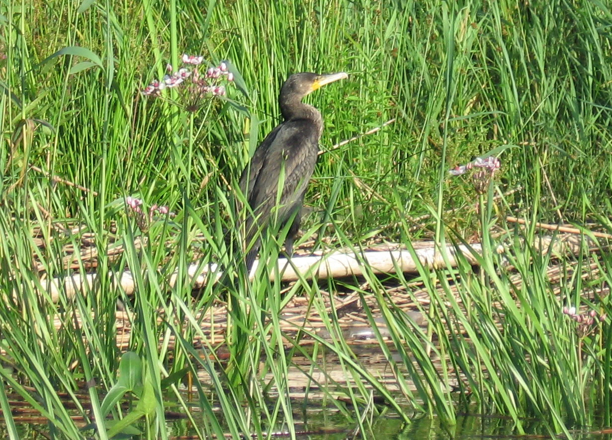
A young, dark-feathered great cormorant standing among lush green riverside vegetation and flowering plants.
A young great cormorant perched among tall river grasses along the Rega River in the Wybrzeże Trzebiatowskie region.

Trzebiatów Coast (Wybrzeże Trzebiatowskie) history and protected-area timeline

Wybrzeże Trzebiatowskie was officially designated as a Special Protection Area in 2007 by Poland's Minister of the Environment, marking the moment when the long coastal strip between Kamień Pomorski and Kołobrzeg received formal bird-focused Natura 2000 status under the European Union's Birds Directive. That designation formalized the area's role as a refuge for 35 bird species listed in Annex II of the directive.

The protection framework was reinforced by the inclusion of four pre-existing and newly established nature reserves within the area: Roby, Jezioro Liwia Łuża, the crowberry coastal pine reserve of Mrzeżyno, and the dune reserve between Dźwirzyno and Grzybowo. Together these reserves add localized, stricter protection to the most ecologically sensitive sites within the broader Special Protection Area.

Over the past several decades, broader land-use shifts have shaped the area's ecology. Many of the meadows and pastures that were once actively mown and grazed by livestock have been abandoned, allowing reed and gray willow communities to expand. Simultaneously, deterioration of drainage infrastructure along the Świniec and Niemica rivers has produced prolonged flooding in the western portion of the area, gradually transforming managed grassland into seasonal wetland and reedbed. The site also partially overlaps with the Trzebiatowsko-Kołobrzeski Pas Nadmorski Community importance area, extending its conservation context within the Natura 2000 network.

Trzebiatów Coast (Wybrzeże Trzebiatowskie) landscape and geographic character

The landscape of Wybrzeże Trzebiatowskie is shaped by the combination of a flat, narrow coastal plain and the dynamic Baltic shoreline. The protected strip follows the southern Baltic coast for about 54 kilometers, producing a strongly elongated geographic footprint. Most of the area lies within the Wybrzeże Trzebiatowskie mesoregion, with its southern edge touching the northern portion of the Równina Gryficka.

Large coastal lagoon lakes are some of the most visible landscape elements. Liwia Łuża and Resko Przymorskie are the two biggest and dominate the hydrological character of the site, while smaller lakes, including Lake Jatkowskie, Lake na Górke, Konarzewo (Bagno Pogorzelickie), and Lake Borek, punctuate the low-lying inland sections. Together these lakes, along with extensive reedbeds and willow thickets, give the area a wetland-rich, low-relief coastal character.

The western portion is defined by the river floodplains of the Świniec and Niemica, where deteriorating drainage has produced persistent rozlewiska and more dynamic flooding patterns. Near the shoreline, the landscape shifts into classic Baltic dune systems and crowberry-pine communities, with the dune reserve between Dźwirzyno and Grzybowo representing one of the highest-quality sandy coastal stretches. The contrast between open water, inundated grassland, reedbeds, and forested dunes gives the area a strongly layered coastal identity.

Trzebiatów Coast (Wybrzeże Trzebiatowskie) ecosystems, habitats, and plant life

Ecologically, Wybrzeże Trzebiatowskie is defined by the close interaction of freshwater, brackish lagoon, meadow, and dune environments along a relatively short stretch of coastline. The presence of the large coastal lagoon lakes Resko Przymorskie and Liwia Łuża anchors the area's value as a complex of nutrient-rich coastal waters, while the surrounding meadows and floodplain remnants add important wet-grassland character.

Roughly 47 percent of the protected zone consists of meadows and former pastures. After the gradual abandonment of mowing and grazing in the last several decades, many of these grassy areas have shifted into reed-dominated stands, with common reed (Phragmyna australis) and gray willow (Salix cinerea) becoming increasingly important habitat-forming species. Where drainage has failed along the Świniec and Niemica rivers, prolonged flooding has produced open water and shallow rozlewiska that support transitional wetland communities.

Along the immediate shoreline, the natural zonation of dune systems, mobile sands, crowberry pine forest (bór bażynowy), and coastal heath demonstrates the characteristic Baltic dune and dry habitat sequence. The combined presence of dune vegetation, pine forest, reedbeds, wet meadows, and lagoon lake margins gives the area a strong ecological gradient across a relatively narrow geographic band.

Trzebiatów Coast (Wybrzeże Trzebiatowskie) wildlife and species highlights

The primary wildlife significance of Wybrzeże Trzebiatowskie lies in its birdlife, which is the reason the area was formally protected. The site supports populations and habitats of 35 bird species listed in Annex II of the EU Birds Directive, reflecting its importance as a refuge for species typically tied to coastal wetlands, open water, and dune systems along the southern Baltic.

The combination of large coastal lagoon lakes, flood-prone meadows along the Świniec and Niemica river valleys, and extensive reedbeds makes the area especially valuable for waterbirds. The presence of reedbeds dominated by common reed and gray willow thickets provides nesting and shelter habitat, while the open waters of Liwia Łuża and Resko Przymorskie support species that depend on larger coastal lake environments.

Beyond birds, the area hosts the broader coastal ecological community associated with dune and crowberry pine forest habitats, as well as the wetland fauna typical of Polish coastal lagoon systems. Because the site was specifically designated under the Birds Directive, however, its conservation identity remains firmly anchored in its ornithological value.

Trzebiatów Coast (Wybrzeże Trzebiatowskie) conservation status and protection priorities

The conservation significance of Wybrzeże Trzebiatowskie is rooted in its formal designation as a Natura 2000 Special Protection Area under the European Union's Birds Directive, with the explicit goal of protecting wild bird populations and maintaining their habitats in an undisturbed state. With 35 Annex II bird species present, the area functions as a key protected site within Poland's contribution to the European bird protection network.

The conservation framework is multilayered. Supervisory responsibility is shared among the Regional Director for Environmental Protection in Szczecin and the maritime offices in Szczecin and Słupsk, while forest areas are administered by the Gryfice Forest District (Regional Directorate of State Forests in Szczecin) and the Gościno Forest District (Regional Directorate in Szczecinn). Within the site, four nature reserves add stricter, more localized protection: Roby, Jezioro Liwia Łuża, Nadmorski bór bażynowy w Mrzeżynie, and Wydmy między Dźwirzynem a Grzybowem.

The site also partially overlaps with the Trzebiatowsko-Kołobrzeski Pas Nadmorski area identified as being of Community importance, extending its conservation role within the broader Natura 2000 habitat network. Together these designations ensure that the area's lagoon lakes, wet meadows, dune systems, and coastal bird habitats are protected under a combination of European, national, and local frameworks.

Top sights and standout views in Trzebiatów Coast (Wybrzeże Trzebiatowskie)

The most distinctive features of Wybrzeże Trzebiatowskie are concentrated in a relatively narrow coastal strip where large lagoon lakes, river floodplains, moist meadows, reedbeds, gray willow thickets, and Baltic dune systems coexist. The two biggest coastal lagoon lakes, Liwia Łuża and Resko Przymorskie, are central landmarks and anchor the area's role as one of the more important Baltic bird protection sites in Poland.

The four embedded nature reserves add extra weight to the site's conservation character: Roby, Jezioro Liwia Łuża, the crowberry pine coastal reserve at Mrzeżyno, and the dune reserve between Dźwirzyno and Grzybowem. The partial overlap with the Trzebiatowsko-Kołobrzeski Pas Nadmorski Community importance area further embeds the site within the broader Natura 2000 framework along the West Pomeranian coast.

Monthly climate preview

Long term temperature and precipitation patterns across twelve recorded months

Wybrzeże Trzebiatowskie Climate Normals and Annual Weather Rhythm

Representative coordinate records show mean temperatures ranging from sub-zero winter lows to warm summer peaks alongside steady daily precipitation. Examining the complete monthly climate dataset reveals the full annual rhythm for this protected area.
Annual mean9 °C
0 °C18 °C
Jan
Feb
Mar
Apr
May12°
Jun16°
Jul18°
Aug18°
Sep15°
Oct10°
Nov
Dec
Warmest month
August

18.4 °C

Coolest month
January

-0.1 °C

Wettest month
July

2.6 mm/day

Driest month
April

1.2 mm/day

Park location guide

Geography guide, regional context, and park location map for Trzebiatów Coast (Wybrzeże Trzebiatowskie)

Trzebiatów Coast (Wybrzeże Trzebiatowskie) park geography, regions, and map view in Poland

Understand where Trzebiatów Coast (Wybrzeże Trzebiatowskie) sits in Poland through a broader geographic reading of the surrounding landscape, nearby location context, and its mapped position within the national park landscape.

How Trzebiatów Coast (Wybrzeże Trzebiatowskie) fits into Poland

Poland, officially the Republic of Poland, is a Central European country spanning from the Baltic Sea in the north to the Carpathian Mountains in the south. It borders Germany, Czech Republic, Slovakia, Ukraine, Belarus, Lithuania, and Kaliningrad Oblast. The country has a temperate climate, diverse landscapes, and is known for its rich history, cultural heritage, and strong economic position within the EU.

Wider geography shaping Trzebiatów Coast (Wybrzeże Trzebiatowskie) in Poland

Poland occupies 312,696 km2 in Central Europe, extending from the Baltic Sea coast in the north to the Sudetes and Carpathian Mountains in the south. It borders Germany to the west, Czech Republic and Slovakia to the south, Ukraine and Belarus to the east, and Lithuania and Kaliningrad Oblast to the northeast. The landscape includes lowland plains, uplands, and mountain ranges.

Map view of Trzebiatów Coast (Wybrzeże Trzebiatowskie)

Use this park location map to pinpoint Trzebiatów Coast (Wybrzeże Trzebiatowskie) in Poland, understand its exact geographic position, and read its mapped placement within the surrounding landscape more clearly.

Pigeon | © OpenStreetMap contributors

Location context for Trzebiatów Coast (Wybrzeże Trzebiatowskie)

West Pomeranian Voivodeship

Visualizing coastal lagoons, dune systems, and wetland habitats along the Baltic Sea

Wybrzeże Trzebiatowskie Photos, Landscapes, and Scenery Visual Explorer

Visual documentation captures the coastal landscapes, lagoon lakes, and wetland habitats defining Wybrzeże Trzebiatowskie across its Baltic shoreline. Examining these protected environments reveals the complex terrain, shifting sand dunes, and reedbeds shaping the regional ecology.

A young, dark-feathered great cormorant standing among lush green riverside vegetation and flowering plants.

A wide, calm lake with a dense patch of tall brown reeds in the foreground and a distant, flat shoreline under a clear blue sky.

Park atlas

Compare regional protected areas and neighboring Baltic wetland habitats.

Explore Parks Near Wybrzeże Trzebiatowskie and Connected Coastal Reserves

Browsing other protected areas near Wybrzeże Trzebiatowskie reveals broader ecological patterns across the West Pomeranian coastline. Comparing adjacent wetland reserves and coastal sanctuaries helps place local lagoon ecosystems into wider regional context.
A soft watercolor painting depicting a calm shoreline with rolling hills and trees in the distance.
Nature reservePoland
Park boundaries overlap#1 closest

Northwest

Ostoja na Zatoce Pomorskiej: Mapping the Pomeranian Bay Marine Nature Reserve

Extensive marine protected landscape in the Baltic Sea

Ostoja na Zatoce Pomorskiej encompasses over 243,000 hectares of the southern Baltic Sea, serving as a primary marine nature reserve for the Polish coast. The sanctuary is defined by complex underwater features such as shallow sandy banks, gravel plains, and the prominent Odrzańska Ławica, which collectively support essential migratory waterbird populations and protected aquatic species within the European ecological network.

Area
2,430.59 km²
Established
2009
Relief
Lowland
Scope
Marine
Nature reserveZachodniopomorskie
Park boundaries overlap#2 closest

Northeast

Trzebiatowsko-Kołobrzeski Pas Nadmorski: Protected Coastal Habitat and Regional Geography

Nature reserve covering Baltic dunes, wetlands, and estuaries.

Spanning across the Szczecin Coastal Plain, this extensive nature reserve protects vital coastal habitats, including rare dune sequences, brackish lagoons, and bog forests. The area serves as a critical geographic corridor for migratory bird species and diverse sand-loving plant communities in the Zachodniopomorskie region of Poland.

Area
174.69 km²
Established
2008
Relief
Lowland
Climate
Temperate
Protected areaZachodniopomorskie
Park boundaries overlap#3 closest

Southwest

Ujście Odry i Zalew Szczeciński: Protected Area Geography and Estuarine Landscape Mapping

Coastal lagoons, riverine deltas, and island habitats in Zachodniopomorskie.

This extensive protected area offers a comprehensive view of the Oder estuary as it meets the Baltic Sea. The landscape comprises broad lagoons, branching river channels, and coastal islands that provide crucial habitat for migratory waterbirds and sustain a rare brackish water ecosystem. Use this geographic entry to analyze the boundaries, terrain, and interconnected waterways of this major Polish nature site.

Area
526.12 km²
Established
2008
Relief
Lowland
Scope
Mixed
Nature reserveWest Pomeranian Voivodeship
About 3.6 km away#4 closest

Southeast

Mszar koło Siemidarżna Nature Reserve: Geography and Protected Wetland Landscapes

Mapping the peatland ecosystems of West Pomeranian Voivodeship

Examine the ecological and geographical profile of Mszar koło Siemidarżna. This nature reserve provides essential insight into the preservation of raised bogs and transitional mires in the lowlands of northwestern Poland. The site highlights the importance of buffer zones in maintaining hydrological integrity for protected pine woodland and rare bog plant species.

Area
0.209 km²
Established
2011
Relief
Lowland
Climate
Temperate
Watercolor painting depicting mountains, rivers, and green terrain
National parkWest Pomeranian Voivodeship
9 km away#5 closest

West

Wolin National Park: Coastal Protected Landscape and Glacial Terrain in West Pomeranian Voivodeship

Explore Poland's first marine national park and its dynamic geography.

Wolin National Park offers a profound look into Poland's protected coastal geography. This national park in the West Pomeranian Voivodeship is distinguished by its high sea cliffs, inclusion of Baltic Sea and Szczecin Lagoon waters as Poland's first marine protected area, and a landscape sculpted by glacial moraines. Discover the park's complex delta systems, ancient forests, and the mapped terrain that supports significant bird migration, providing a rich focus for atlas exploration.

Area
109.37 km²
Established
1960
IUCN
II
Visitors
1.5M annual
National parkZachodniopomorskie Voivodeship
9 km away#6 closest

West

Woliński Park Narodowy: Atlas Overview of Protected Coastal and Marine Environments

Examining moraine landscapes and marine park boundaries.

Woliński Park Narodowy stands as a critical protected area in the Zachodniopomorskie Voivodeship, blending terrestrial moraine ridges with marine ecosystems. This atlas entry provides geographic context for its coastal cliffs, inland lake district, and the expansive river delta that supports rare avian species.

Area
109.37 km²
Established
1960
Visitors
1.5M annual
Relief
Upland
A horizontal watercolor painting showing rolling green hills and a dense forest line against a pale, light-colored sky background.
Protected landscapeWest Pomeranian Voivodeship
13 km away#7 closest

South

Puszcza Goleniowska Protected Landscape: Geographic Profile and Mapped Boundaries

A large-scale lowland forest complex in West Pomeranian Voivodeship.

Puszcza Goleniowska represents a critical protected woodland in Poland, spanning 630 square kilometers of post-glacial plains. This forest complex is characterized by its pine-dominated canopy, widespread bog and marshland habitats, and a series of rivers and lakes that form the backbone of its regional drainage. The area encompasses numerous nature reserves and Natura 2000 sites, offering a comprehensive look at the lowland ecological structure of the West Pomeranian Voivodeship.

Area
630 km²
Established
1349
Relief
Lowland
Climate
Temperate
Protected areaZachodniopomorskie
22 km away#8 closest

Southwest

Łąki Skoszewskie Protected Area: Geography, Mapped Terrain, and Wetland Landscapes

Coastal marshland and bird sanctuary in Zachodniopomorskie

Located along the Szczecin Lagoon, Łąki Skoszewskie consists of extensive wet meadows, alder carrs, and Scots pine forests. This protected area provides a detailed look at the hydrological networks and coastal transition zones that define the unique natural landscape of northwestern Poland.

Area
90.834 km²
Established
2004
Relief
Lowland
Climate
Temperate

Common questions about visiting, size, designation, and location context for Trzebiatów Coast (Wybrzeże Trzebiatowskie)

Trzebiatów Coast (Wybrzeże Trzebiatowskie) FAQs for park facts, access, geography, and protected area context

Find quick answers about Trzebiatów Coast (Wybrzeże Trzebiatowskie), including protected-area facts, park geography, trail and visitor context, and how the park fits into its surrounding country and regional landscape.
MoriAtlas Explorer

Continue Your Protected Areas Search Across the Global Atlas

Deepen your exploration by continuing the structured search for national parks and protected areas worldwide. Utilize the comprehensive filtering capabilities to compare different conservation landscapes and refine your understanding of global park geography. Discover more about the distribution and characteristics of protected natural areas.

Global natural geography